North America

North America History
Anthropologists believe that North America's initial inhabitants arrived around 40,000 years ago by traversing the Bering Strait. Some experts feel that by using primitive boats, early man also migrated down the Pacific coast to South America; that debate continues.
There is scientific evidence connecting indigenous Americans to Asian peoples, specifically from the eastern Siberian populations. Indigenous peoples of the Americas have been linked to North Asian populations by linguistic dialects and blood types.
After the last glacial period ended some 12,500 years back, a wide variety of prehistoric cultures developed across the continent, north to south. The development of stone tools was one of the factors instrumental in that successful expansion.
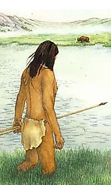
Long before the Europeans arrived, small groups developed throughout the Americas. Across the Great Plains hunter-gatherers existed on wild plants and animals, but they were eventually replaced by more sophisticated bands that farmed the land, raised some animals and improved their hunting skills.
At about the time of Christ, the brown-skinned Arawak People migrated from Venezuela to the Lesser Antilles. Small groups settled on many islands in the southeastern Caribbean, eventually reaching the Greater Antilles, creating their largest settlements on the islands of Cuba, Hispaniola, Puerto Rico, and Jamaica
In the far-southern reaches of the continent important cultural advances were made by the Maya civilization. They developed written language, as well as far-reaching advances in art, architecture, astronomical systems and mathematics. From the years 250 to 900, they were at the pinnacle of their power.
In North America, sophisticated pre-Columbian cultures continued to develop. Across regions of what is now the United States, social organization were building mound complexes, with some supporting sizable communities year-round.
Native American societies continued to spread; the Inuit and the Aleut lived in domed-shaped dwellings in the Arctic regions while large groups inhabited the Subarctic parts of Alaska and western Canada. From the Northeast to the Southeast, and from the Plains to the Southwest, the expansion continued unabated.
As large groups gained additional knowledge, they began to farm some familiar crops now used around the world, such as tomatoes and squash. Perhaps most importantly they developed farming techniques for one of the planet's major foods, maize (corn).

The Vikings were seafaring north Germanic people who raided, traded, explored, and settled in wide areas of Europe, Asia, and the North Atlantic islands from the late 8th to the mid-11th centuries. Using sturdy wooden longships they traveled as far west as Iceland, Greenland, and Newfoundland. Leif Erikson is believed to have reached the Island of Newfoundland, Canada - circa 1000 AD
In the 13th century, central Mexico was the center of the Aztec civilization. The Mayan culture was fading and the Aztec Empire now stretched across most of Mesoamerica, from Mexico to Belize, Guatemala,El Salvador, Honduras, Nicaragua, and northern Costa Rica.
In 1492, after proposing a voyage of discovery to the then mostly-imagined New World, Christopher Columbus left Spain on an epic journey, financed by Isabella I and Ferdinand II, Queen and King of Spain. Within a few months he reached land in the Bahamas, and North America would change forever.
After Columbus made his initial voyage to this New World, word of its potential riches spread across Europe and explorers and settlers by the thousands would eventually step ashore along the Atlantic Ocean coastline of North America.
John Cabot explored the east coast of what would become Canada in 1497. Giovanni da Verrazzano explored the East Coast of North America from Florida to eastern Canada in 1524, and Jacques Cartier made a series of voyages on behalf of the French crown in 1534 and penetrated the St. Lawrence River.
In 1500, the Spanish made their move to colonize parts of the New World. The city of Nueva Cádiz was founded on the Venezuela island of Cubaqua. In 1510 they established Santa María la Antigua del Darien near the border of Colombia and Panama: these were the first European settlements in the Americas.
The first mainland Spanish explorations were a series of inland expeditions that led to the conquest of Mexico and the Yucatan Peninsula. In 1513, Vasco Nunez de Balboa crossed the Isthmus of Panama to find gold, but instead led the first European expedition to the Pacific Ocean and the west coast of the New World.

Balboa then claimed the Pacific Ocean and all the lands adjoining it for the Spanish Crown. Hernan Cortes and his conquistadors came ashore at present day Veracruz, Mexico on April 22, 1519, and it marked the beginning of 300 years of dominate Spanish influence over most of Mexico, Central America and the Caribbean.
In 1539, Hernando de Soto landed at Tampa Bay in what is now the US State of Florida. With 600 soldiers in tow, his goal was to find gold for the Spanish Crown. At that same time natives on the continent lived without fear as they were ignorant of the outside world. Soon their innocence disappeared, as Europeans began to stake their claims, frequently in brutal ways.
As a result of European exploration the Native American population declined substantially, primarily due to the introduction of European diseases to which the Native Americans lacked immunity, as well as from violent conflicts where they were no match for European fire power.
Not to be outdone, Britain and France (as well as Spain) were beginning to establish extensive territories in the northern reaches of the continent. Even lesser-powers like the Netherlands and Sweden laid claim to smaller parts.
The first French settlements were established at Port Royal (1604) and Quebec City (1608) in what is now Nova Scotia and Quebec, Canada. In 1607, the first successful English settlement was built at Jamestown, Virgina, followed by the Plymouth, Massachusetts colony in 1620.
Near the end of the 17th century the colonialism of North America was at full speed, and inevitable disagreements and greed were the genesis for a series of regional wars, and some of the European territories changed hands multiple times. In fact, the Caribbean island of Tobago changed hands 33 times.

In the middle of the 18th century, independence movements were on the front-burner across the continent. An American Revolution was brewing within the English colonies, Spain's hold on Mexico was weakening and slave revolts were common in the Caribbean.
By the end of the century, a handful of independence movements came to fruition across the North America continent. The 13 original British Colonies declared independence in 1776, and after the American Revolutionary War ended in 1783, they became the United States of America. Canada was formed from the unification of northern territories once controlled by Britain and France.
The new country of America's 1803 Louisiana Purchase from France almost doubled its size overnight. This massive transfer of land included all of present-day Arkansas, Oklahoma, Missouri, Kansas, Nebraska and Iowa; most of Colorado, South Dakota, Montana and Wyoming, as well as significant parts of North Dakota, Minnesota, Texas and Louisiana.
New Spain, a territory that stretched from the southwestern modern-day U.S. through Central America declared independence in 1810, becoming the First Mexican Empire. Guatemala, then part of that Mexican Empire, became the first independent state in Central America.

For many reasons, including the possibility of America's interest in annexing Canada, the War of 1812 began when the United States declared war on the British. The 32-month military conflict (fought on many fronts) resulted in no territorial change between the British Empire and the USA, but a resolution of many issues which remained from the American War of Independence.
With space too limited here to detail, we highlight a series of important land agreements and compromises that occurred in North America through the end of the 19th century. They include: The Republic of Texas formed as an independent sovereign nation in 1836; the Rebellions of 1837 in Lower and Upper Canada; the creation of the Mexican Empire, with the support of Napoleon III of France in 1864, and the creation of the Dominion of Canada in 1867.
Arguably, the two most devastating events on the North America continent were the American Civil War (from 1861 to 1865), a conflict that led to the end of slavery in the United States, but it brought destruction to most of the South, and a tremendous loss of life. It was followed by the United States government fighting numerous Indian Wars against the Native Americans for land acquisition; tens of thousands died as a result.
Following the Civil War, America's intervention into Latin America and elsewhere expanded. The 1867 Alaska Purchase was the acquisition of what is now the US State of Alaska from the Russian Empire. During the Spanish–American War of 1898, the US seized several colonies from Spain including Cuba and Puerto Rico.

In 1914, the Panama Canal opened. the 48-mile (77.1 km) ship canal in Panama connecting the Atlantic Ocean (via the Caribbean Sea) to the Pacific Ocean enabled ships to avoid the lengthy Cape Horn route around the southernmost tip of South America.
At the end of World War I (fought from 1914 to 1918 in Europe) the early 20th century brought an age of great prosperity to the United States, and to a lesser degree Canada. But the Stock Market Crash of 1929 was the most devastating stock market crash in the history of the United States, and that crash affected all Western industrialized countries and did not end in the United States until the onset of American mobilization for World War II in 1941.
In Mexico, from 1936 to 1949, there was a popular uprising against the anti-Catholic government. In the Caribbean, many islands witnessed the beginnings of decolonization, while on the island of Cuba, the Cuban Revolution introduced the Soviet Union (now Russia) into Latin America.
World War II was a global conflict that lasted from 1939 to 1945. It involved the vast majority of the world's nations—including all of the great powers, including Canada and the US. The destruction of Europe wrought by the war vaulted all North American countries to more important roles in world affairs, and the United States emerged as a "superpower."
Mexico also experienced an era of huge economic growth after World War II, a heavy industrialization process and a growth of its middle class, a period known in Mexican history as the "El Milagro Mexicano" (Mexican miracle). In 1960, Guatemala, El Salvador, Honduras and Nicaragua banded together to find a common economic bond.
In 1962, Guatemala, and Trinidad and Tobago became politically independent. This event ushered in a period of formal decolonization of the English-speaking Caribbean. Since 1962, Jamaica and Trinidad and Tobago were joined by Antigua, the Bahamas, Barbados, Belize, Dominica, Grenada, St. Lucia and St. Vincent.
The early Cold War era saw the United States as the most powerful nation in a Western coalition of which Mexico and Canada were also a part. At home, the United States witnessed violent change especially in the area of race relations. In Canada this was mirrored by the Quiet Revolution and the emergence of Quebec nationalism.
During this time the United States became involved in the Vietnam War. That war would later prove to be highly divisive in American society, and American troops were withdrawn. Canada during this era was dominated by the leadership of Pierre Elliot Trudeau. Eventually in 1982 at the end of his tenure, Canada had a new constitution.

Major changes continued into the 21st century: Mexico experienced a strong economic recession in the 1980s, the Canada-United States Free Trade Agreement was reached in January 1989, and on January 1, 1994, Canada, Mexico and the United States of America signed the North American Free Trade Agreement, creating the world's largest free trade area.
Those major economic events were followed by the 9/11 attacks on the United States, and the subsequent war in Afghanistan - participated in by Canada and the US. In 2006, the violent drug war spread from Central America to Canada, and that human tragedy reached a deadly peak in Mexico in the last few years. In 2008, a financial crisis that began the United States eventually triggered a worldwide recession, an economic slowdown that has now wained some.
Surviving powerful earthquakes, hurricanes, tornadoes, contentious immigration issues and isolated terrorism attacks, the twenty-three countries and the dozens of possessions and territories within North America have found ways to (for the most part) co-exist in peace, and to economically benefit by working together. Today the diverse and massive continent of North America present a bright potential future for all of its people, and for that matter, much of the modern world.
North America Geography Notes
Two of North America's most interesting geographical features are the Great Plains and the Mississippi River System; both impressive in so many ways.
Great Plains: The Great Plains of North America slope east from the Rockies and extend to the edge of the Canadian Shield and the western edges of the Appalachians. The land is generally smooth with large treeless areas and shallow river valleys. Minor hills and mountains are found in the Ozark Plateau of Missouri, and in the Boston Mountains and Ouachita Mountains of northwestern Arkansas and eastern Oklahoma. Sandhills and buttes cover parts of the north central U.S. in Nebraska.
Mississippi River System: It is the major river of North America and the United States at (2,339 miles) (3,765 km) in length. It flows from northwestern Minnesota south to the Gulf of Mexico, just below the city of New Orleans. It is a significant transportation artery and when combined with its major tributaries (the Missouri and Ohio rivers) it becomes the third largest river system in the world at (3,877 miles) (6,236 km) in length.
North America Geography Facts
- Percent of Earth's Land: 16.5%
- Highest Point: Mt McKinley in Alaska, 20,322ft (6,194m) (see map)
- Lowest Point: Death Valley in California, -282 ft (-86m) below sea level (see map)
- Geographic Center: The United States Geographical Survey states that the geographic center of North America is "6 miles west of Balta, Pierce County, North Dakota" at approximately 48° 10´ N 100° 10´ W. (see map)
- Horizontal Width: From San Francisco, California, east to New York City, NY: 2,582 miles (4,156 km) (see map)
- Vertical Length: From Barrow, Alaska, directly southeast to Panama City, Panama: 5,347 miles (8,605 km) (see map)
Note: Lengths and widths are point-to-point, straight-line measurements and will vary some using other map projections.
Note: For additional geography details please use the yellow navigation bar at the top of this page.
North America Information
Links to North America information that are updated daily.
- North America famous native sons and daughters
- North America facts and figures, capital cities and currency
- North America country flags
- North America land statistics, highest and lowest points
- North America landforms, lakes, mountains and rivers
- North America latitude, longitude and relative locations
- North America links to major attractions and points of interest
- North America maps, outline, political and topographical
- North America symbols, coat of arms and flags
- North America time zones and current times
- North America timeline of events and history
- North America travel information, airfares, cruises and train travel
- North America weather forecasts and current conditions
North America Countries
This list does not include the island dependencies and overseas territories in the Caribbean.
- Antigua and Barbuda
- Bahamas
- Barbados
- Belize
- Canada
- Costa Rica
- Cuba
- Dominica
- Dominican Republic
- El Salvador
- Grenada
- Guatemala
- Haiti
- Honduras
- Jamaica
- Mexico
- Nicaragua
- Panama
- Saint Kitts and Nevis
- Saint Lucia
- Saint Vincent and the Grenadines
- Trinidad and Tobago
- United States
North America Map
North America, the planet's 3rd largest continent, includes (23) countries and dozens of possessions and territories. It contains all Caribbean and Central America countries, Bermuda, Canada, Mexico, the United States of America, as well as Greenland - the world's largest island.
Positioned in the planet's northern and western hemispheres, it's bordered in the north by the Arctic Ocean, in the east by the Atlantic Ocean, in the southeast by the Caribbean Sea and Gulf of Mexico, and in the west by the Pacific Ocean.
Additional North American countries (not shown on this map) include: Antigua and Barbuda, Barbados,Dominica, Grenada, Haiti, St. Kitts & Nevis, St. Lucia, St. Vincent & the Grenadines and Trinidad & Tobago.
North America Topographical Map

A typical topographic-type map highlights hills, mountains and valleys of a specific land area by exaggerated shading rather than by using contour lines. It also includes major bodies of water, and some rivers. This topo map clearly shows how the Rocky Mountains and it various ranges dominate the western-third of the continent (see below). In addition, it also highlights the Appalachian Mountains in the eastern U.S., a range of about 1,500 miles in length, that extends from central Alabama through the New England states and the Canadian provinces of New Brunswick, Newfoundland and Quebec.
Rocky Mountains

This is a slice of the large topographical (or relief) map shown here, one that highlights the Rocky Mountains, arguably the most dramatic landform is all of North America. Additional features clearly visible include some of the larger rivers on the continent and one of the most interesting geography features of the United States. Note the depression to the north of Death Valley and west of the Sierra Nevada. This is both the San Joaquin Valley (south), and the Sacramento Valley (north), one of the most fertile farming areas in the country.
For additional details on many of the geography features of North America, this page will help
North America Satellite View Map

This NASA satellite view of North America can be useful in many applications, including agriculture, geology, forestry, meteorology, intelligence and warfare. In addition, it's a great education tool as it provides an overview of the snow covered lands of the far north, and the Great Plains that slope east from the Rockies and extend to the edge of the Canadian Shield and the western edges of the Appalachians. That land is generally flat with large treeless areas and shallow river valleys.
North America Outline Map

North America Political Map

Political maps are designed to show governmental boundaries of countries, states, and counties, the location of major cities, and they usually include significant bodies of water. Like the sample above, bright colors are often used to help the user find the borders. A larger version of this map here.
World Facts
Useful information on populations and more that are updated weekly.


