Landforms of North America, Mountain Ranges of North America, United States Landforms, Map of the Rocky Mountains - Worldatlas.com

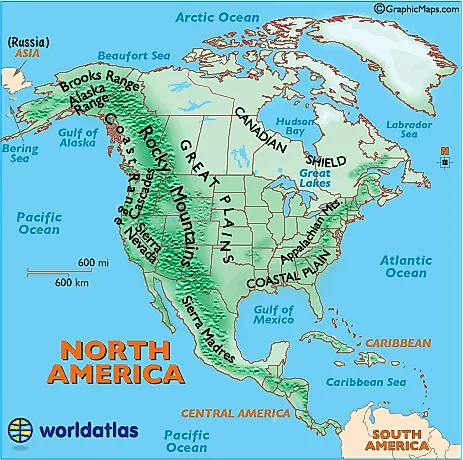
Great Plains:
The Great Plains of North America slope east from the Rockies and extend to the edge of the Canadian Shield and the western edges of the Appalachians. The land is generally smooth with large treeless areas and shallow river valleys. Minor hills and mountains are found in the Ozark Plateau of Missouri, and in the Boston Mountains and Ouachita Mountains of northwestern Arkansas and eastern Oklahoma. Sandhills and buttes cover parts of the north central U.S. in Nebraska.
Rivers: Major rivers of North America
Rocky Mountains:
The Rocky Mountains, about 3,000 miles in length, extend from the U.S State of New Mexico up through the western United States and on into the northernmost reaches of Canada's British Columbia. Major mountain ranges include...
- Absaroka
- Bear River
- Beaverhead
- Big Belt
- Big Horn
- Bitterroots
- Canadian
- Clearwater
- Columbia
- Front
- Guadalupe
- Laramie
- Lemhi
- Lewis
- Lost River
- Medicine Bow
- Monashee
- Owyhee
- Purcell
- Sacramento
- Salmon River
- San Andres
- Sangre de Cristo
- Sawatch
- Shoshone
- Steens
- Stillwater
- Swan
- Tetons
- Unita
- Wallowa
- Wasatch
- Wind River
- Wyoming
- Zuni
The highest point in the Rockies is Mt. Elbert, located 10 miles southwest of Leadville, Colorado. It stands at 14,433 ft (4,399 meters).
Alaska Range:
Mountains of south-central Alaska that extend from the Alaska Peninsula to the border of the Yukon Territory, Canada. The highest point in North America, Mt. McKinley, 20,320 ft. (6,194 m) is located here.
Appalachian Mountains:
The Appalachians, about 1,500 miles in length, extend from central Alabama in the U.S. up through the New England states and the Canadian provinces of New Brunswick, Newfoundland and Quebec.
Significant Appalachian ranges include:
- The Cumberland Mts. in Tennessee
- The Blue Ridge Mts. in Virginia
- The Alleghenies in Pennsylvania
- The Catskills Mts. in New York
- The Green Mts. in Vermont
- The White Mts. of New Hampshire
The highest point is Mt. Mitchell in North Carolina at 6,684 ft (2,037 m)
Brooks Range:
Mountains of northern Alaska. Highest point: Mt. Isto, 9,060 ft. (2,760 m)
- Cordillera Central (Dominican Republic)
- Cordillera de Talamanca (Costa Rica)
- Cordillera Isabelia (Honduras/Nicaragua)
- Maya Mountains (Belize)
- Sierra de Bahoruco (Haiti)
- Serrania de Tabasara (Panama)
- Sierra Maestra (Cuba)
Sierra Nevada:
This mountain range of eastern California is about 400 miles in length. The highest point isMt. Whitney at 14,494 ft. (4,418 meters).