The Largest Watersheds in the United States
A watershed is the land area where all rainfall and snowmelt drain into a shared outlet, usually a river, lake, or ocean. The United States contains hundreds of watersheds, but a handful dominate the landscape, shaping ecosystems, agriculture, transportation, and drinking‑water supplies across vast regions. This article highlights the largest watersheds in the U.S., which together cover millions of square miles. These watersheds matter because they support major cities, power agriculture, influence flood patterns, and anchor some of the country’s most iconic travel destinations. Rankings are based on total drainage area in square miles (mi²), with metric equivalents in parentheses.
Mississippi River Watershed - Area: ~1,200,000 mi² (3,110,000 km²)

The Mississippi River watershed is the largest in the United States and drains about 41% of the continental U.S. Its tributaries, including the Missouri, Ohio, and Arkansas Rivers, span from the Rocky Mountains to the Appalachians and from Canada to the Gulf of Mexico. This enormous system supports barge transportation, agriculture, freshwater fisheries, and migratory bird routes. Its size also contributes to environmental challenges, such as nutrient runoff into the Gulf. For travellers, the watershed encompasses iconic regions such as the Upper Midwest, the Great Plains, and the Mississippi Delta.
Colorado River Watershed - Area: ~246,000 mi² (637,000 km²)

The Colorado River watershed drains a rugged region of the American West, including parts of Wyoming, Colorado, Utah, Arizona, Nevada, and California. It carved the Grand Canyon, but today it is best known for supplying water to 30-40 million people and irrigating major agricultural valleys. The watershed includes iconic landscapes such as the Rocky Mountains, Canyonlands, and Lake Powell. Because the region is naturally dry, the watershed is heavily managed through dams, reservoirs, and interstate compacts, making it central to ongoing discussions about drought and long‑term water security.
Columbia River Watershed - Area: U.S. portion ~219,000 mi² (567,000 km²); total ~258,000 mi² (668,000 km²)

The Columbia River watershed dominates the Pacific Northwest, draining portions of Washington, Oregon, Idaho, Montana, Wyoming, Nevada, and British Columbia. It is the largest watershed on the West Coast and one of North America’s most powerful river systems. The Columbia’s steep gradients make it ideal for hydropower, and its dams generate more electricity than any other river system in the U.S. The watershed also supports world‑class salmon runs, fertile agricultural valleys, and scenic destinations like the Columbia River Gorge. Its mix of mountains, forests, and volcanic landscapes makes it one of the most visually striking watersheds in the country.
Yukon River Watershed - Area: U.S. portion ~205,000 mi² (531,000 km²); total ~330,000 mi² (855,000 km²)

Although much of the Yukon River watershed lies in Canada, the U.S. portion, primarily in Alaska, is still one of the largest drainage basins in the country. The watershed flows through remote tundra, boreal forests, and mountain ranges before reaching the Bering Sea. It supports Indigenous communities, salmon fisheries, and some of the most intact wilderness in North America. For travellers, the watershed includes the Yukon Flats, the Alaska Range, and long stretches of river accessible only by bush plane or boat. Its size and remoteness make it a critical refuge for wildlife and a benchmark for studying climate change in northern ecosystems.
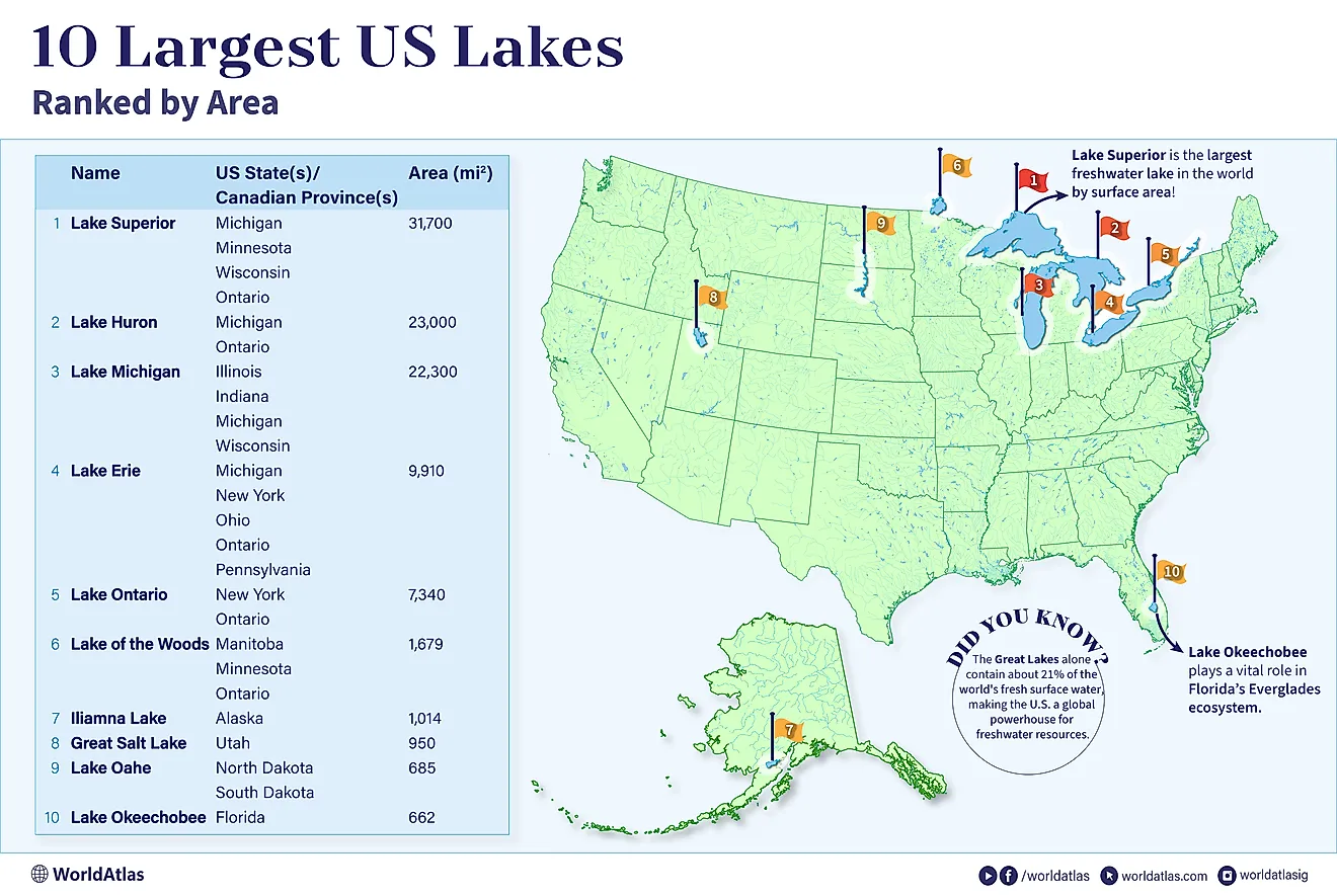
Great Lakes - St. Lawrence Watershed - Area: U.S. portion ~197,000 mi² (510,000 km²); total ~295,000 mi² (765,000 km²)

The Great Lakes - St. Lawrence watershed in the United States spans portions of eight states, Illinois, Indiana, Michigan, Minnesota, New York, Ohio, Pennsylvania, and Wisconsin, and forms one of the world’s largest freshwater drainage basins. It holds 20% of Earth's surface freshwater, feeding Lakes Superior, Michigan, Huron, Erie, and Ontario. For travelers, this vast region offers an incredible variety of experiences: sandy freshwater beaches, dramatic dunes, island archipelagos, historic port cities, and thousands of rivers and streams that flow into the lakes. The U.S. side of the watershed is home to major cultural hubs like Chicago, Detroit, Cleveland, and Buffalo, as well as countless small coastal towns perfect for road‑tripping.
Rio Grande Watershed - Area: U.S. portion ~185,000 mi² (479,000 km²); total ~335,000 mi² (868,000 km²)

The Rio Grande watershed stretches across Colorado, New Mexico, Texas, and northern Mexico, draining a vast region of deserts, mountains, and high plains. Despite its size, the watershed is relatively dry, making the Rio Grande essential for irrigation, drinking water, and wildlife habitat. Snowmelt from the Rockies feeds the upper basin, while the lower basin is shaped by arid landscapes and international water‑sharing agreements. The watershed includes dramatic destinations such as Big Bend National Park, the San Luis Valley, and the Chihuahuan Desert.
Watersheds Matter

These watersheds shape everything from agriculture and hydropower to wildlife migration and regional travel experiences. They influence where cities grow, how goods move, and how ecosystems respond to droughts, floods, and climate shifts. Whether you’re exploring the Mississippi Delta, rafting the Colorado, hiking the Columbia Gorge, or flying over the Yukon, these watersheds define the landscapes and waterways that make the United States geographically diverse and endlessly fascinating.