The Largest Man-Made Lakes in the United States
Man-made lakes are artificial bodies of water created by damming a river or stream, generally for flood control, hydroelectric generation, drinking-water storage, irrigation, navigation, recreation, or some combination of these. The United States contains around 53,000 man-made lakes, which is roughly half of all the lakes in the country. The list below ranks the largest by surface area, starting with Lake Oahe on the Missouri River, working through the other major Missouri River reservoirs, and finishing with the largest in the South, West, and Eastern United States. Surface area shifts with water level, so the rankings are based on figures at or near full pool; some of the lakes below are now well below that.
Lake Oahe

Lake Oahe was formed by the Oahe Dam on the Missouri River. The Oahe Dam's hydroelectric turbines produce around 2.8 billion kilowatt-hours of electricity annually, enough to power roughly 259,000 homes. The lake extends about 231 miles (372 kilometres) from just north of Pierre, South Dakota nearly to Bismarck, North Dakota. It has a surface area of 685 square miles (1,774 square kilometres) at full pool, with around 2,250 miles of shoreline. Because Lake Oahe is a storage reservoir, water volume shifts regularly, particularly during droughts.

Beyond hydroelectric generation, Lake Oahe is a major fishing destination. Anglers come for northern pike, smallmouth bass, channel catfish, and walleye, the last of which produces some of the largest specimens in the country. The recreation areas along the lake receive about 1.5 million visitors a year.
Lake Sakakawea

Lake Sakakawea is another Missouri River reservoir, running through central and western North Dakota. It is 180 miles (290 kilometres) long, with about 1,320 miles (2,125 kilometres) of shoreline, which is more than the entire Pacific coast of California. Its surface area at full pool is around 520 square miles (1,347 square kilometres). The reservoir was filled in 1953 behind Garrison Dam, built by the U.S. Army Corps of Engineers. Garrison Dam is the fifth-largest earthen embankment dam in the world by volume of fill material, generates 583 megawatts of hydroelectric power, and stands 210 feet tall.

The lake takes its name from Sakakawea, the Hidatsa-Shoshone woman who travelled with the Lewis and Clark expedition through this region more than 220 years ago. Walleye is the most popular catch, with northern pike, chinook salmon, and smallmouth bass also present in good numbers.
Fort Peck Lake

Fort Peck Lake is the largest body of water in Montana by surface area, covering about 245,000 acres (roughly 383 to 393 square miles, depending on water level). It was created between 1933 and 1940 by the Fort Peck Dam across the upper Missouri River in northeastern Montana. The dam itself is 21,026 feet long (just under four miles), the largest hydraulically filled earthen dam in the United States. Fort Peck Lake's shoreline runs about 1,520 miles, which is longer than the entire Pacific coast of California.

Fort Peck Lake has a reputation as a major fishing destination, particularly for trophy-sized channel catfish, paddlefish, and king salmon (which can run 16 to 30 pounds in this lake). The state record catfish has been broken on Fort Peck several times. Twenty-seven designated recreation areas line its shores, and the surrounding Charles M. Russell National Wildlife Refuge wraps the reservoir on nearly every side.
Toledo Bend Reservoir

Toledo Bend Reservoir covers about 185,000 acres (around 289 square miles) on the Sabine River between Texas and Louisiana, making it the largest reservoir in Texas and the largest man-made lake in the Southern United States. The Toledo Bend Dam, roughly 80 miles northeast of Beaumont, was begun in 1964; impoundment started in 1966 and the dam was completed in 1969 at a total project cost of about $70 million.

The land around the lake is largely undeveloped timberland inside the Sabine National Forest. With around 1,200 to 1,260 miles of shoreline depending on the source, Toledo Bend supports swimming, boating, and fishing, and is widely regarded as one of the top bass fisheries in the country thanks to submerged timber that creates habitat for fish, high stocking density (some sections hold roughly 300 pounds of game fish per acre), and an active annual fingerling restocking programme.
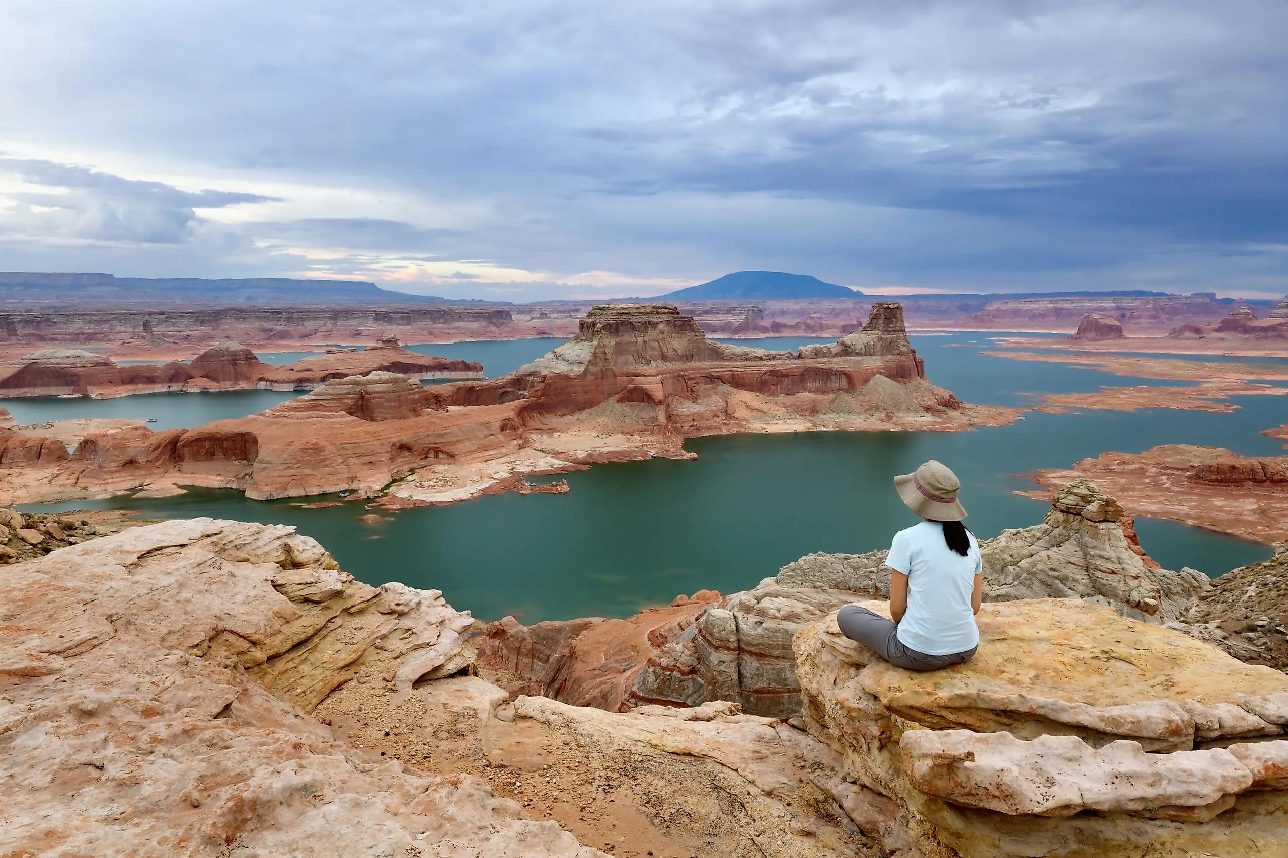
Lake Powell

Lake Powell began to fill in 1963 behind Glen Canyon Dam in northern Arizona. It straddles the Arizona-Utah border and is designed to hold around 26 million acre-feet of water at full pool, drawn from snowpack in the Upper Colorado River Basin states of Colorado, Utah, Wyoming, and New Mexico. It is the primary storage reservoir for water from the Green, Gunnison, San Juan, and Colorado Rivers, eventually released downstream to Lake Mead and the Lower Colorado River Basin states of Arizona, Nevada, and California.

Lake Powell's surface area at full pool is around 251 square miles (650 square kilometres), though actual surface area has run well below that during the 2000-2020s Colorado River drought. The lake supplies water to more than 40 million people across the seven Colorado Basin states and Mexico, and is also a major recreation area featuring 96 major canyons and the surrounding sandstone formations.
Kentucky Lake

Kentucky Lake, with a surface area of about 250 square miles (160,300 acres), is the largest artificial lake by surface area in the United States east of the Mississippi River. It spans Kentucky and Tennessee and was created by Kentucky Dam on the Tennessee River. Dam construction began in 1938 and concluded in 1944 when the reservoir began to fill. Kentucky Lake's flood storage capacity (over 4 million acre-feet) lets Kentucky Dam reduce or temporarily stop the Tennessee's outflow, which in turn lowers flood crests on the Ohio and Mississippi Rivers.

Kentucky Lake receives around 17 million visitors a year along its 2,064 miles of shoreline. Boat docks, resorts, state parks, and the Tennessee National Wildlife Refuge serve vacationers and anglers. Kentucky Dam's five turbine generators produce about 1.3 billion kilowatt-hours of electricity per year for the Tennessee Valley Authority grid.
Lake Mead

Lake Mead is the reservoir behind Hoover Dam on the Colorado River, on the Arizona-Nevada border about 24 miles (39 kilometres) east of Las Vegas. Its surface area at full pool is 247 square miles (640 square kilometres) and its capacity at full pool is around 28.3 million acre-feet, the largest design capacity of any reservoir in the United States. Lake Mead has not actually reached full pool since 1983, however. Population growth in the cities supplied by the Colorado (Las Vegas, Phoenix, Los Angeles, San Diego) combined with reduced Rocky Mountain snowpack and the long Colorado River drought has steadily reduced the river's flow and the lake's stored volume.

As part of the Lake Mead National Recreation Area, the reservoir provides access to boating, fishing, swimming, hiking, camping, and biking. Since 1999, lake levels have dropped consistently, and the lake reached its historic low in 2022. That same year, Lake Mead's low-level emergency pumps, built specifically for severe drought conditions, were switched on for the first time. Many boat ramps have since been closed or restricted to smaller vessels because of the receding shoreline.
The Pattern Across the List
Lake Oahe, Lake Sakakawea, and Fort Peck Lake on the upper Missouri dominate the top of the list by surface area; Lake Mead and Lake Powell on the Colorado dominate by design capacity but are running well below it. Kentucky Lake is the largest east of the Mississippi, and Toledo Bend the largest in the South. Across all of them, the same trade-off shows up: the dams that built these reservoirs deliver flood control, hydropower, drinking water, navigation, and recreation, but the lakes themselves are increasingly hostage to drought and changing snowpack. The headline surface-area numbers in this list are the upper bound. The actual reservoirs in any given year are smaller.


