The Most Geologically Unique Lakes in North America
During the last Ice Age, retreating glaciers left North America with nearly 1 million sapphire lakes. Canada alone holds more than 62 percent of the world's total. Roughly 70 percent of those lakes formed glacially. Others took shape through tectonic shifts or volcanic eruptions. The six lakes ahead are accessible to visitors and stand out for unusual geology or biodiversity.
Lake Huron
Lake Huron shares a unique hydrological connection with Lake Michigan, linked by the Straits of Mackinac at a single water level. The two lakes are sometimes considered a single lake system as a result. Combined, Lake Michigan-Huron would be the largest freshwater lake in the world by surface area.
Huron has a surface area of about 23,007 mi² (59,588 km²) and a maximum depth of 750 ft (229 m), making it the third-largest of the Great Lakes. What sets the lake apart is the more than 30,000 islands scattered across its surface. Many are inhabited, but the standout is Manitoulin Island, the largest lake island in the world. Manitoulin contains more than 100 of its own lakes, several of which contain their own islands.
The biodiverse region around Huron includes two rare blooming orchids, the bog green orchid and the white northern bog orchid. The species occupy fens, marshes, meadows, and river and lakeshore margins around the basin. Huron has also avoided heavy urbanization compared with the other Great Lakes, which has allowed rare Carolinian forests to persist along its shores. Carolinian and mixed species cover about 68 percent of the watershed.
Lake Winnipeg

Canada has many lakes beyond the Great Lakes that hold their own unique stories and geology. Lake Winnipeg is a strong example, with the largest watershed of any lake in Canada. The lake covers 9,465 mi² (24,514 km²) and reaches a maximum depth of 118 ft (36 m).
The southern end of the lake sits about 34 miles (55 kilometers) from the Manitoba capital, Winnipeg, which keeps recreational traffic steady. The nearby town of Gimli hosts one of North America's oldest continuous ethnic festivals at the Icelandic Festival of Manitoba. Despite the visitor traffic, the lake has remained relatively clean.
Part of the reason for Winnipeg's clean state and reportedly the whitest beaches in Canada is the 40-plus communities around the lake, many of them First Nation and Métis, that preserve and care for the watershed. Local stewardship runs right down to the fishing regulations. The lake supports walleye, goldeye, sauger, and whitefish, with commercial fishing capped to keep stocks viable.
Great Bear Lake

Great Bear Lake is the eighth-largest lake in the world by surface area at approximately 12,123 mi² (31,400 km²) and 1,463 ft (446 m) deep. Located in the Northwest Territories, the lake is renowned for its clarity. One apocryphal account from explorer John Franklin in 1828 noted that a white rag dropped in the water did not disappear until it exceeded a depth of 15 fathoms (90 ft, 27 m).
The lake sits near the Arctic Circle, which adds some unusual seasonal characteristics.
Great Bear also produces some of the largest freshwater fish in the world for anglers willing to make the trip. In 1995, a 72-pound (32.65 kg) lake trout was caught here, which remains the largest lake trout ever caught by angling. The Northwest Territories now operates under a catch-and-release policy for trophy lake trout, which has kept the chances of hooking unusually large fish high.
Lake Athabasca

Lake Athabasca sits within the Athabasca Basin, the region that produces roughly 15 to 20 percent of the world's annual uranium supply. Lake Athabasca's northern shore was historically known for both gold and uranium deposits, and mining activity in the area was lucrative enough at one point to support the boomtown of Uranium City in northern Saskatchewan, now largely depopulated.
Pollution concerns from nearby oil sands mining have grown in recent decades, but Lake Athabasca has held up as a mineral-rich resource that has not displaced its wildlife. The 3,031 mi² (7,849 km²) of water host trophy fish including lake trout, Arctic grayling, northern pike, whitefish, and walleye. Wood Buffalo National Park, Canada's largest national park, sits to the north, and the Athabasca Sand Dunes Provincial Park lies along the lake's southern shore.
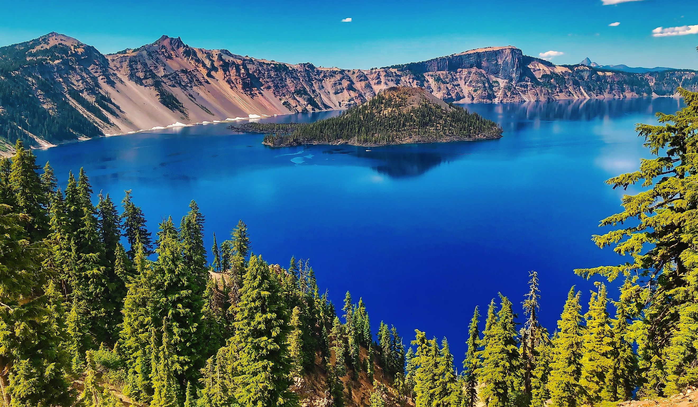
Crater Lake

Crater Lake formed around 7,700 years ago when Mount Mazama erupted catastrophically and collapsed into itself, creating the caldera that the lake now fills. The eruption was witnessed by Native peoples of the region, whose oral histories preserve the event. There are no inflowing or outflowing waterways. The basin fills entirely from rain and snowmelt, making the water some of the purest in the country. At a measured 1,949 feet (594 m), Crater Lake is also the deepest lake in the United States.
To protect the water quality and keep invasive species out, visitors cannot bring their own boats or kayaks. Boat tours run during summer, and swimming is permitted only at the designated Cleetwood Cove access point. Beyond the lake itself, the surrounding 183,224 acres of mountains, peaks, and evergreen forests provide habitat for a wide range of wildlife.
Lake Tahoe

Lake Tahoe is the largest alpine lake in North America by volume and trails only the Great Lakes among American lakes in surface area. Set into the Sierra Nevada that feeds it, Tahoe is renowned for its clarity and depth, with rain-fed waters that visitors can often see down through to depths of 70 feet or more. At 1,645 ft (501 m), it is also the second-deepest lake in the United States behind Crater Lake.
The lake basin formed roughly 2 million years ago through faulting and subsequent glacial activity in the Lake Tahoe Basin. Its surface is large enough that atmospheric refraction over the water produces optical effects including "looming" and "Fata Morgana," some of which may account for local sightings of Tahoe Tessie, the lake's resident folkloric monster.
No Two Lakes Quite The Same
Rare orchids around Lake Huron and the deep clarity of Lake Tahoe are just two of the features that set these North American lakes apart. Reading about them is interesting, but nothing replaces an actual visit, where the data and superlatives become secondary to direct experience. The continent's hundreds of thousands of lakes are a near-endless source of wonder, and these six are a good place to start the next trip.


