Major Rivers Of Europe
The Volga is Europe's longest river at 3,531 km, flowing entirely within Russia and draining into the Caspian Sea. The Danube comes second at 2,850 km but touches more countries than any other river in the world (ten in all), with its source in the Black Forest of Germany and its delta on the Black Sea. The Rhine and the Danube are connected via the 171-km Rhine-Main-Danube Canal, finished in 1992, which now allows commercial barges to travel between the North Sea and the Black Sea. On the Dnieper, the catastrophic destruction of the Kakhovka Dam on June 6, 2023 reshaped the lower river and remains one of the largest environmental incidents in Europe since Chornobyl. The twelve European rivers ahead each carry a distinct geographical, economic, and ecological story.
Contents
- Danube River
- Dnieper River
- Don River
- Elbe River
- Loire River
- Oder River
- Po River
- Rhine River
- Rhône River
- River Shannon
- Tagus River
- Volga River
Danube River

The Danube runs about 2,850 km and is Europe's second-longest river. It rises at the confluence of the Brigach and Breg rivers, near the German town of Donaueschingen in the Black Forest region of Germany. The river then runs through central and southeastern Europe, passing through ten countries: Germany, Austria, Slovakia, Hungary, Croatia, Serbia, Romania, Bulgaria, Moldova, and Ukraine. Its principal tributaries include the Inn, Drava, Tisza, Sava, and Prut. The Danube finally drains into the Black Sea through the Danube Delta, which is shared between Romania and Ukraine and protected as a UNESCO World Heritage Site.
The Danube serves as one of the most significant commercial waterways on the continent and supplies drinking water, hydroelectric power, irrigation, fishing, and navigation for the countries that share its basin. The 171-km Rhine-Main-Danube Canal, completed in 1992, connects the Danube with the Rhine and ultimately with the North Sea, enabling continuous inland navigation across western and central Europe.
Dnieper River

The Dnieper (called Dnipro in Ukrainian) runs about 2,200 km and ranks as Europe's fourth-longest river. It rises from peat bogs in the Valdai Hills of western Russia, about 150 miles west of Moscow, at an elevation of around 220 metres. The river runs generally south through Smolensk Oblast in Russia, then through Belarus, before crossing Ukraine on its way to the Black Sea at the Dnipro-Bug Estuary near Kherson. Major tributaries include the Berezina, Drut, Sozh, Desna, Pripyat, and Samara. The Dnieper is the longest river of Ukraine and Belarus.
The river was the spine of Soviet-era hydroelectric development, with six dams and reservoirs built along its course beginning in the 1930s. The southernmost of those, the Kakhovka Dam, was destroyed on June 6, 2023 during the Russian invasion of Ukraine, releasing about 14 cubic kilometres of water from the 2,155-square-kilometre reservoir and inundating roughly 620 square kilometres of the lower Dnieper basin. More than 100 people died in the flood and the breach remains the largest environmental disaster in Europe since the Chornobyl accident. Reconstruction had not begun as of 2026, and the former reservoir bed has begun to revegetate with willow forest.
Don River

The Don runs about 1,870 km and is Europe's fifth-longest river. It rises near the town of Novomoskovsk in Russia's Tula Oblast, about 60 km southeast of Tula and 193 km south of Moscow, on the eastern slope of the Central Russian Upland. The river then runs generally south through Lipetsk, Voronezh, Volgograd, and Rostov oblasts before curving east close to the Volga, then turning southwest into the Gulf of Taganrog in the Sea of Azov. Major tributaries include the Seversky Donets, Khopyor, Medveditsa, Chir, and Chyornaya Kalitva.
The Don's eastern arc brings it within roughly 80 km of the Volga, and the 101-km Volga-Don Ship Canal (completed in 1952) connects the two rivers. Combined with the Tsimlyansk Reservoir on the Don's lower course, the canal turned the Don into a navigable trunk line connecting the Black Sea, Sea of Azov, and Caspian Sea.
Elbe River

The Elbe runs about 1,112 km and originates in the southern Krkonoše (Giant) Mountains near the Polish-Czech border. It then runs through the northwestern Czech Republic and across eastern Germany before emptying into the North Sea near Cuxhaven. Major tributaries include the Vltava (which is actually longer than the Elbe above the confluence in Prague), Saale, Mulde, Ohře, Schwarze Elster, and Havel.
The Elbe is among Europe's most monitored rivers for water-quality recovery. Heavy chemical pollution during the Cold War left the river severely contaminated, but coordinated cleanup since the early 1990s by Germany and the Czech Republic has restored much of its ecological function.
Loire River

The Loire runs about 1,006 km and is the longest river in France. It rises in the foothills of the Massif Central in the Cévennes mountain range, in the French department of Ardèche, and runs north and then west across France before draining into the Bay of Biscay near Saint-Nazaire. Major tributaries include the Allier, Cher, Indre, Vienne, Maine, and Sèvre Nantaise.
The middle Loire valley is the most visited stretch, registered as a UNESCO World Heritage Site since 2000 for its concentration of Renaissance châteaux including Chambord, Chenonceau, and Amboise. The 94,480-acre Forest of Orléans in the central valley is the largest national forest in France, and the broader Loire basin supports about 164 bird species and 57 fish species.
Oder River
The Oder runs about 840 km and is the second-longest river in Poland after the Vistula. It rises in the Oderské vrchy hills of the eastern Czech Republic and runs through southwestern Poland, then forms part of the Polish-German border along its lower course. The main channel empties into the Szczecin Lagoon, which then drains to the Baltic Sea through three outlets: the Peene, Świna, and Dziwna. Major tributaries include the Lusatian Neisse (which forms much of the Polish-German border), Warta, and Bóbr.
Po River

The Po runs about 652 km and is the longest river in Italy. It rises in the Cottian Alps at Pian del Re and runs west to east across the broad Po Valley of northern Italy before emptying into the Adriatic Sea through a multi-channel delta. The river passes Turin, Piacenza, Cremona, and Ferrara, with Milan sitting in its basin but not directly on the main channel. Major industrial centres along the basin draw heavily on Po water for cooling and process use. The river receives roughly 141 tributaries including the Adda, Ticino, Tanaro, Dora Riparia, and Mincio.
The Po basin has experienced increasingly severe drought conditions in recent years, particularly during the 2022 European drought when river levels dropped to record lows and saltwater intrusion reached unprecedented distances inland up the Po delta.
Rhine River

The Rhine runs about 1,230 km and originates in the southeastern Swiss Alps in the Canton of Grisons, Switzerland. The Alpine Rhine forms the international boundary between Switzerland and Liechtenstein and then between Switzerland and Austria before flowing into Lake Constance. The High Rhine exits the lake heading west, forms Switzerland's border with Germany, and drops 23 metres at the Rhine Falls near Schaffhausen, the largest plain waterfall in Europe by water volume. At Basel the river turns north as the Upper Rhine and forms the border between Germany and France. The Middle Rhine cuts through the famous gorge between Bingen and Koblenz, a UNESCO World Heritage Site since 2002. The Lower Rhine reaches the Netherlands and divides into three main distributaries: the Waal (the principal navigable branch), the Lek, and the IJssel. These eventually empty into the North Sea through the combined Rhine-Meuse-Scheldt delta. Major tributaries include the Aare, Neckar, Main, Lahn, Moselle, and Ruhr. Principal cities along the river include Basel, Strasbourg, Mannheim, Cologne, Düsseldorf, and Rotterdam.
Rhône River

The Rhône runs about 813 km and originates at the Rhône Glacier in the Swiss Alps. The fast-flowing upper river runs west into the eastern end of Lake Geneva, exits the lake at Geneva, and crosses into France. It then runs south through Lyon (where it picks up the Saône, its largest tributary) and the Rhône Valley before splitting at Arles into the Grand Rhône and Petit Rhône and emptying into the Mediterranean Sea through the Camargue delta. The Camargue, where the two arms meet the sea, is one of Europe's largest river deltas and home to flamingos, semi-feral white horses, and the Camargue cattle breed.
River Shannon

The Shannon runs about 360.5 km and is the longest river in the Republic of Ireland. It rises from the Shannon Pot, a small pool on the slopes of Cuilcagh Mountain in County Cavan, and runs south through a chain of lakes including Lough Allen, Lough Ree, and Lough Derg before turning west to drain into the Atlantic Ocean via the Shannon Estuary at Limerick. The river crosses or borders 11 Irish counties and its basin covers about one-fifth of Ireland's total land area. The Ardnacrusha hydroelectric station on the lower Shannon, commissioned in 1929, was once the largest hydroelectric facility in the world and remains in operation today.
Tagus River

The Tagus (Tajo in Spanish, Tejo in Portuguese) runs about 1,007 km and is the longest river on the Iberian Peninsula. It rises in the Sierra de Albarracín, part of the Montes Universales mountain range in the eastern part of Spain, and runs westward across central Spain past Toledo before forming a short stretch of the Spain-Portugal border. It then enters Portugal, where it picks up the name Tejo and widens into the Tagus estuary at Lisbon before emptying into the Atlantic Ocean. Major tributaries include the Jarama, Alberche, Alagón, Zêzere, and Almonte. The basin holds more than ten million inhabitants including the metropolitan areas of Madrid and Lisbon, making it the most populous river basin in Iberia. The Roman bridge at Alcántara in western Spain, completed in 106 CE, has spanned the Tagus for nearly 2,000 years.
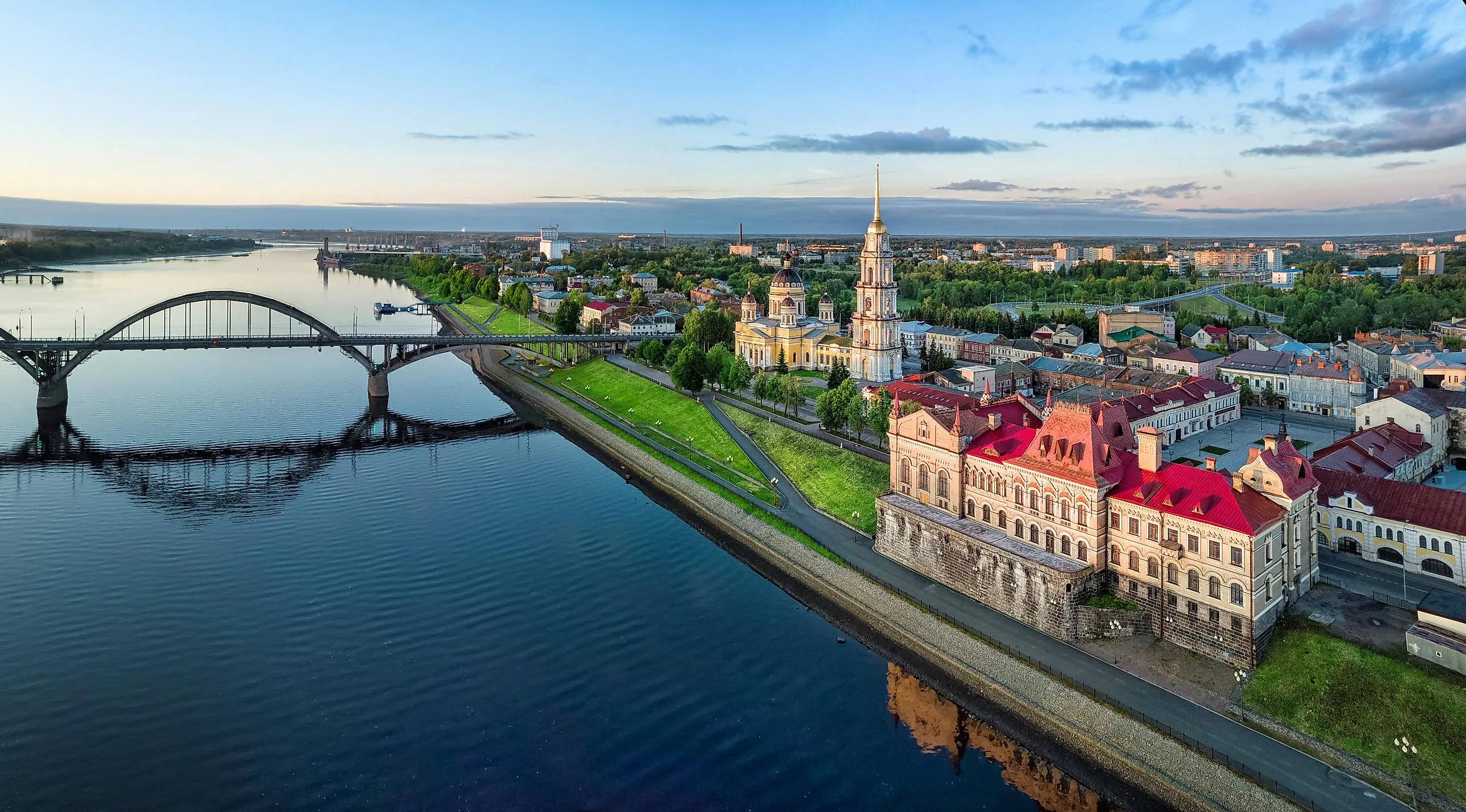
Volga River

The Volga runs about 3,531 km and is the longest river in Europe. It is widely regarded as the national river of Russia. It rises in the Valdai Hills of Tver Oblast at about 225 metres above sea level, then runs east past Tver, Yaroslavl, Nizhny Novgorod, and Kazan before turning south through Samara, Saratov, and Volgograd, and discharging into the Caspian Sea below Astrakhan at 28 metres below sea level. Major tributaries include the Kama (the largest), Oka, Vetluga, and Sura.
The Volga drains most of western Russia and supports about half the country's population. Soviet-era engineering left a chain of eight large reservoirs along the river, including the Rybinsk Reservoir at 4,500 square kilometres. The Volga is connected to the White Sea (via the Volga-Baltic Waterway), the Baltic Sea, the Caspian Sea, the Sea of Azov, and the Black Sea (via the Volga-Don Canal), making it the centrepiece of the most extensive inland waterway system in Europe. The Volga Delta, where the river meets the Caspian Sea, is the largest river delta in Europe at about 27,000 square kilometres and is the only place in Russia where wild lotuses and Dalmatian pelicans both occur.
Twelve Rivers, Twelve Stories
These twelve European rivers between them touch nearly every country on the continent, drain four seas (the Caspian, Black, Baltic, and North) plus the Mediterranean and the Atlantic, and support most of the continent's industrial economy and roughly half its population. The Volga and Danube dominate the eastern and central reaches by sheer length. The Rhine and Po anchor central and southern Europe's heavy industrial corridors. The Loire, Tagus, and Shannon shape the western Atlantic-facing economies. The Dnieper carries the most pressing recent ecological story with the 2023 Kakhovka disaster. Together, these rivers form the geographic backbone of the continent.


