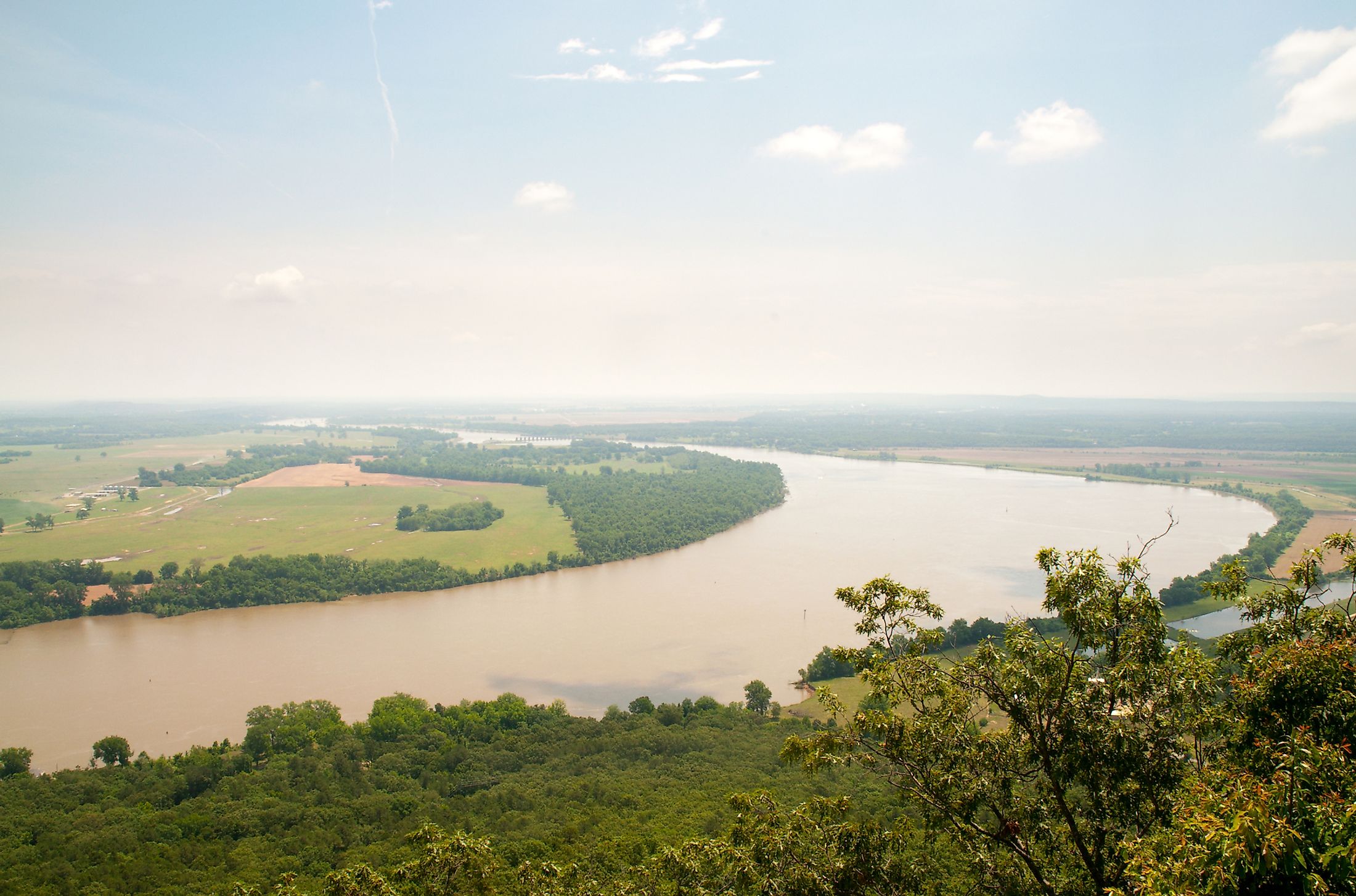
Arkansas River
The Arkansas River is the US's sixth-longest river and one of the Mississippi River’s major tributaries, covering 2,364 kilometers. It originates from the Rocky Mountains in Colorado and flows through three states, Colorado, Kansas, and Oklahoma, before entering Arkansas, where it joins the Mississippi River at Napoleon. The Arkansas River is the world’s 45th longest lake and the Mississippi-Missouri River system’s second-longest tributary. However, it has a much smaller volume than Ohio and Missouri, with an average discharge of 1,100 cubic meters per second. Its drainage basin stretches 440,000 square kilometers. Some of the major cities located along the river banks include Kansa, Wichita, Oklahoma, and Tusla.
Origin Of The Name
Before the arrival of the Europeans, several native nations lived along the banks of the Arkansas River, including the Quapaw Indians. The Natives called the river “Napeste.” In 1541, the Spanish explorers became the first Europeans to discover the Arkansas River, with Hernando de Soto becoming the first Spanish to see the river’s confluence with the Mississippi River. The Spanish referred to the river as “Rio Napestie.” When the French explorers visited the areas, they referred to the rivers as “Riviere d’Ozark” or Riviere des Ark.” The name “Arkansas” was first used by Jacques Marquette, a French father, who referred to the river as “Akansa” in his 1673 journal. The name “Akansa” was derived from one of the Algonquian terms for the native Quapaw people.
River Source And Course

The headwaters of the Arkansas River rise from the snowpack Rocky Mountain’s Mosquito and Sawatch Range, near Leadville, Colorado. The East Fork Arkansas River rises from the Mosquito Range and flows for about 33.2 kilometers before joining the Tennessee Creek near Leadville to form the Arkansas River. This point of confluence is located at an elevation of about 2,965 meters above sea level.
From Leadville, Colorado, the Arkansas River flows southeastwards for about 160 kilometers to Canon City, Colorado, with the elevation falling to 2,060 meters above sea level. The river exit Canon City via a narrow canyon with 300 meters high wall known as Royal Gorge and flows into John Martin Reservoir located near Animas. At the reservoir, the river receives inflow from the Purgatoire River. The Arkansas River meanders through an extensively irrigated dry land on its way to the Great Bend in Kansas.

From the Great Bend, the river flows southeastwards into Oklahoma where it receives inflow from main tributaries like Salt Fork, Verdigris, Cimarron, and Grand rivers. The Arkansas River Navigation System joins the river at Muskogee, where the Verdigris River joins the Arkansas River. It then crosses into Little Rock and Fort Smith, Arkansas, and makes its way to Napoleon, where it joins the Mississippi River. The Arkansas River has changed its course over the years. The ancient sediment deposit in Nolan of the Tensas Basin suggests the river may have flowed through the region up to about 5200 BP.
The Three Sections Of The River

The Arkansas River, flowing across Central US, is one of the Mississippi River’s important tributary. It is divided into three parts; upper, middle, and lower Arkansas River. The upper Arkansas River is the portion that flows from the Rocky Mountains through the rugged terrain, with the elevation dropping to 1,400 within 200 kilometers. This section is popular for trout fishing and whitewater rafting.
The middle portion runs through the Great Plains. As the river flows into the Royal Gorge, the Arkansas River valley flattens and widens remarkably. Its gradient declines as it flows through Pueblo, Colorado, where it transforms into a classical Great Plain river characterized by shallow and wide channels and flood plains. The major rivers joining the middle Arkansas River include the Cimarron and Canadian Rivers, each exceeding 1,000 kilometers in length.
The lower Arkansas River has similar characteristics as those of the Mississippi River. This section flows through a generally flat surface, maintaining slow back and forth meanders. Series of dams and reservoirs are have been built along the river, making it navigable by craft and barges. The lower river portion also carries more sediments delivered to it by its tributaries.
Historical Significance

Native Americans lived on the river bank for years before the arrival of the Europeans. The Spanish explorers first sited the river in 1541, with Hernando de Soto discovering its confluence with the Mississippi River in the 1540s. The Arkansas post was established in 1686 by Henri de Toti, with the post becoming the first major European settlement in the region. Between 1718 and 1719, Jean-Baptiste Benard de la Harpe was on an expedition to Oklahoma. While there, he was welcome by natives who lived near the Arkansas River and spent ten days with them.
The Arkansas River played a central role in the European expansion. The French traders and trappers who traded with the Indians tribes in Canada and areas around the Great Lakes explored much of the Mississippi River, including most northern tributaries. Since they could not use the light birchbark canoes on the southern waterways, including the Arkansas River, the French turned into making dugout canoes known as “pirogues.”
The Arkansas River was a hotspot during the American Civil War, with both sides preventing each other from accessing and using the river to move their weapons and enforcements. Initially, the Confederate troops occupied the area while they supported its Native American allies. However, the Union army later defeated the Confederates at the Battle of Fort Smith and the Battle of Pea Ridge and reopened the Arkansas River for its supply. In 1864, the Confederates captured and destroyed a Union ship that was headed to Fort Gibson.
Economic Significance
Since the 19th century, the Arkansas River’s headwaters in Colorado has supported trout fishing, especially fly fishing. Although the greenback cutthroat trout was the river’s most common species in the 19th century, the brown trout currently the most dominant species. Other common species include the rainbow trout.
The McClellan-Kerr Arkansas River Navigation System (MKARNS), extending from Oklahoma to the Mississippi River contains 18 locks and dams, all widened and deepened to make the river navigable. This section of the lower Arkansas River supports large commercial traffic and sustains recreational activities. Besides, the MKARNS’ completion provided several benefits to the lower basin, including wildlife conservation, water supply, flood control, and hydropower generation. Commodities shipped through the MKARNS include wheat, petroleum products, farm products, steel, and iron.