The Most Populated Islands in the Great Lakes
The Great Lakes and their connecting waterways, spanning across the borders of both Canada and the United States, contain an estimated 35,000 islands. However, relatively few of those islands have permanent populations. Most of them are uninhabited or sparsely used, ranging from tiny rocky outcrops to forested islands, private lands, and protected areas.
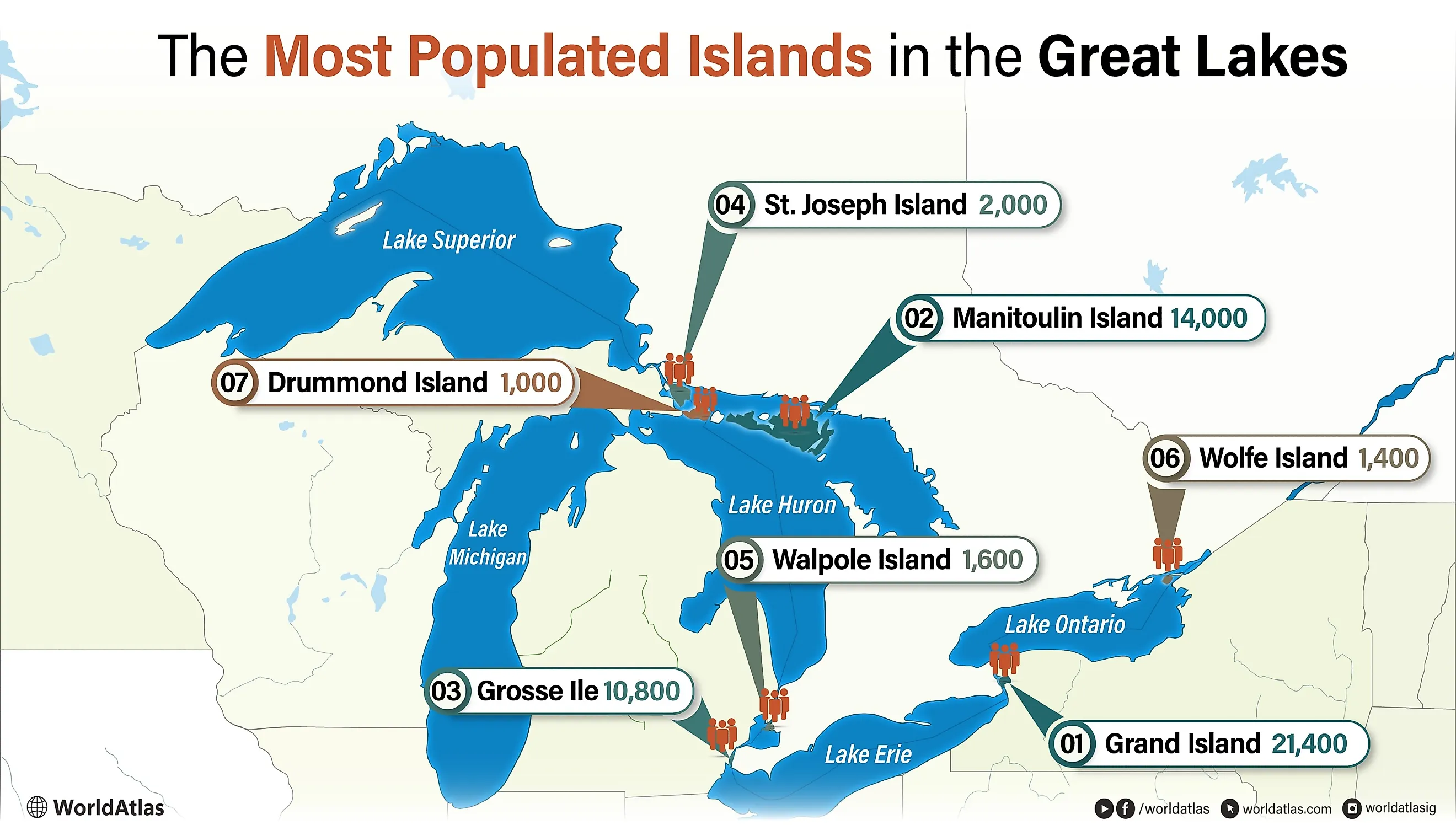
There are, however, a handful that host decently sized, permanent pockets of civilization. Grand Island has the largest population among these Great Lakes waterway islands, with about 21,400 residents, while places like Manitoulin Island and Wolfe Island show how permanent communities vary widely across the region. Learn more about the most populated islands in and around the Great Lakes, concentrated mainly in Lake Huron and scattered across the world’s most renowned network of connected freshwater lakes.
The Most Populated Islands in the Great Lakes
- 1. Grand Island, Niagara River - 21,400 residents
- 2. Manitoulin Island, Lake Huron - 14,000 residents
- 3. Grosse Ile, Detroit River - 10,800 residents
- 4. St. Joseph Island, Lake Huron - 2,000 residents
- 5. Walpole Island, Lake St. Clair - 1,600 residents
- 6. Wolfe Island, Lake Ontario - 1,400 residents
- 7. Drummond Island, Lake Huron - 1,000 residents
Grand Island, Niagara River - 21,400 residents

Grand Island is located in New York, in the Niagara River between Lake Erie and Lake Ontario. Covering about 33 sq mi (85.5 km²), it is the largest island in the river by landmass, and although it does not sit directly on a Great Lake, it is still very much a part of the region. It is the most populous island connected to the Great Lakes waterway system, with approximately 21,400 full-time residents (as per the 2020 US Census).

It is part of Erie County and functions largely as a suburban extension of Buffalo, with the island connected to the mainland by the South Grand Island Bridge and the North Grand Island Bridge, both carrying Interstate 190 across the river. Even with its notable suburban growth, large portions of Grand Island still remain green spaces and waterfront habitat. Beaver Island State Park, for one, occupies much of the southern shoreline and includes beaches, marinas, and trails overlooking the Niagara River, whereas Buckhorn Island State Park can be conveniently accessed at the other side, right under the North Grand Island Bridge.
Historically, Grand Island was inhabited by several native tribes at various times. It then attracted the interest of early French explorers, later became associated with farming, and later still with resort development, boating, and river recreation for residents of upstate New York and visitors from nearby Canada.
Manitoulin Island, Lake Huron - 14,000 residents

Manitoulin Island is situated between Georgian Bay and Lake Huron and is the largest freshwater island in the world, covering about 1,068 mi² (2,766 km²). The island is part of the Manitoulin District in Ontario, Canada, and includes a mix of incorporated towns and First Nations communities. It currently has a permanent population of around 14,000, making it easily the most populous island in one of the Great Lakes.

Major population centers include Northeastern Manitoulin and the Islands, Central Manitoulin, and Assiginack, while the Wiikwemkoong Unceded Territory is the largest Indigenous community on the island and one of the most significant in Ontario as a whole. Economically, it relies on tourism, agriculture, and fishing, with seasonal population increases sometimes numbering 40,000 during the summer months. The majority of visitors arrive from the mainland via the Little Current Swing Bridge or by the MS Chi-Cheemaun ferry from the Bruce Peninsula/Tobermory.
Key geographic features include Bridal Veil Falls and sections of the Niagara Escarpment, a UNESCO World Biosphere Reserve that crosses the island. Manitoulin Island also contains 108 inland lakes, including Lake Manitou, the largest lake on a freshwater island anywhere in the world.
Grosse Ile, Detroit River - 10,800 residents

In the middle of the Detroit River in Michigan, a vital waterway that connects Lake Erie to Lake St. Clair, sits Grosse Ile. It lies just south of Detroit and forms part of Wayne County. This island measures about 9.6 mi² (24.9 km²) and has a population of almost 10,800 (as per the 2020 US Census), mainly concentrated in a suburban residential pattern rather than a more rural setting.
Grosse Ile is connected to the mainland by the Grosse Ile Toll Bridge and the Wayne County Bridge, making it also quite functionally integrated with the Detroit metropolitan area. Furthermore, it includes several other smaller surrounding islands that are part of the township.
Historically, the island originally developed through French settlement in the 18th century and later became a strategic site for military and aviation use, including the construction of the Naval Air Station Grosse Ile, which operated until 1969. Today, land use here is dominated by residential neighborhoods, marinas, and parkland, including Elizabeth Park on one of the smaller adjacent islands. With that, boating, fishing, and even hiking remain central to local tourism.
St. Joseph Island, Lake Huron - 2,000 residents

St. Joseph Island rests in the very far northwestern corner of Lake Huron in Ontario, just southeast of Sault Ste. Marie. Covering about 141 mi² (365 km²), it is another one of the larger inhabited islands in this region. The island has a year-round population of roughly 1,400 to 2,000 residents, spread across a variety of small, rural communities such as Richards Landing, Hilton Beach, and Jocelyn Township.
Connected to the mainland by a free bridge carrying Ontario Highway 548, like Manitoulin, St. Joseph Island is also very easily accessible. As you may have imagined, agriculture plays a central role in the local economy, too, particularly hay production and maple syrup, each supported by the island’s relatively mild microclimate.
The island has a long history, serving as a base of operations for early European settlers and native inhabitants long before that. It is perhaps best known as an important British military site during and after the War of 1812, with Fort St. Joseph (now a national historic site) serving as a buffer against American positions across the border. Currently, tourism is the main draw for visitors here, driven by fishing, boating, historical sightseeing, and seasonal events such as the long-running St. Joseph Island Maple Syrup Festival held every April.
Walpole Island, Lake St. Clair - 1,600 residents

Walpole Island can be found at the mouth of the St. Clair River on the Canadian side, where it enters Lake St. Clair. It forms part of a delta system rather than a single landmass, with channels and wetlands separating it from neighboring islands. It sits within one of the largest remaining freshwater delta ecosystems in North America, with extensive marshes, channels, and tallgrass prairie. This landscape in turn supports large numbers of diverse birdlife, fish populations, and plant species, alongside its human residents.
Spanning about 53 mi² (137.5 km²) and boasting a population of over 1,600 residents, the majority of its inhabitants are members of the Walpole Island First Nation (Bkejwanong Territory). While the census-reported population is under 2,000, local counts are estimated to be much higher because many residents are not captured in official census data.
Walpole Island is connected to mainland Canada by a small bridge; however, access is also available via a small ferry linking it to Algonac, reinforcing its relative isolation despite proximity to urban centers in southern Ontario and Michigan.
Wolfe Island, Lake Ontario - 1,400 residents

Wolfe Island is at the eastern end of Lake Ontario near the border of New York and close to the point where the lake feeds into the St. Lawrence River, marking the end of the Great Lakes before its water reaches the Atlantic Ocean. It is the biggest island in the Thousand Islands region, covering about 48 mi² (124 km²).

Wolfe Island has a permanent population of roughly 1,400 residents, with numbers bumping up during the summer months. It is largely flat and agricultural, with open farmland, limestone bedrock, and long shorelines exposed to strong winds. These conditions have supported the development of large-scale wind energy, most notably the Wolfe Island Wind Farm, one of the largest onshore wind projects in Canada. Because of this, farming, commuting, and energy production account for most of the local industry here, alongside seasonal tourism, often focused on cycling, wineries, birding, and waterfront access.
Moreover, Wolfe Island is part of Frontenac County, Ontario, and is closely tied to the nearby city of Kingston, located just across a narrow channel to the north. With that, it is accessible by a free year-round ferry from Kingston to Marysville, the island’s main settlement, as well as a seasonal ferry linking it to Cape Vincent (which is currently closed and slated for a 2027 reopening).
Drummond Island, Lake Huron - 1,000 residents

Just south of the American border from St. Joseph Island lies Drummond Island, which covers about 134 mi² (347 km²). It is located in the northern channel of the St. Marys River, where Lake Superior flows towards Lake Huron. Drummond Township, which includes Drummond Island and nearby smaller islands, had 973 residents in the 2020 census. As usual, numbers increase during the summer tourism season as the weather goes from deeply wintry to pleasantly warm.
This sizable island is part of Chippewa County and can be reached only by ferry from DeTour Village in Michigan's Upper Peninsula. Once you arrive, you will quickly see that the landscape here is indeed quite wild, shaped by exposed bedrock, a plethora of shallow inland lakes, and extensive coastal wetlands, too. Large swathes are undeveloped, with forests, marshes, and shoreline habitats supporting deer, black bears, and migratory birds. It also contains notable geological features, including fossil-rich limestone formations, notably at the Fossil Ledges on the island's northern shoreline.
Recreation is a major part of life on Drummond Island. Activities include angling, boating, and off-road vehicle use, particularly on designated trail systems that attract visitors. On the other hand, residential areas are concentrated near the ferry landing, while much of the interior remains sparsely settled.
The Most Populated Islands in the Great Lakes
| Rank | Island | Waterway | Population* |
|---|---|---|---|
| 1 | Grand Island | Niagara River | 21,400 |
| 2 | Manitoulin Island | Lake Huron | 14,000 |
| 3 | Grosse Ile | Detroit River | 10,800 |
| 4 | St. Joseph Island | Lake Huron | 2,000 |
| 5 | Walpole Island | Lake St. Clair / St. Clair River delta | 1,600 |
| 6 | Wolfe Island | Lake Ontario | 1,400 |
| 7 | Drummond Island | Lake Huron / St. Marys River system | 1,000 |
(*Populations are approximate, rounded, and based on 2020 US Census Data and 2021 Canadian Census Data.)
Explore Beyond the Shores of the Great Lakes
From remote communities in Lake Huron to densely settled islands near major cities, the Great Lakes host a remarkable range of islands, some with notable year-round communities. While many developed around farming, shipping, fishing, or industry, others remain closely tied to tourism and Indigenous culture. Destinations such as Manitoulin Island, Grand Island, and Wolfe Island particularly highlight the geographic diversity and human history spread across these North American inland seas.


