The Largest And Smallest Canadian Provinces/Territories By Area
Canada is an absolutely massive country. At approximately 9.985 million km2 (3.8 million mi2), it is the second largest country in the world, behind Russia.
Stretching from the Pacific Ocean in the west to the Atlantic Ocean coast in the east and up to the Arctic Ocean up north, Canada spans a massive variety of landscapes and ecological zones, from deciduous forests to vast mountain ranges and even deserts.
Canada is made up of 10 provinces and three territories, all of which govern different portions of the country.
Geography Of Canada
Land makes up 91.08% of the country’s area, while water makes up 8.92%. The country’s coastline stretches for 151,019 miles, and it touches the three oceans: Pacific, Atlantic, and Arctic. The nation’s border with the US extends for 5,525.85 miles. The country’s highest point is Mount Logan, with an elevation of 19,551 feet, and the lowest point is in the Atlantic Ocean. Canada’s population is approximately 40 million people. Its population is mainly urbanized.
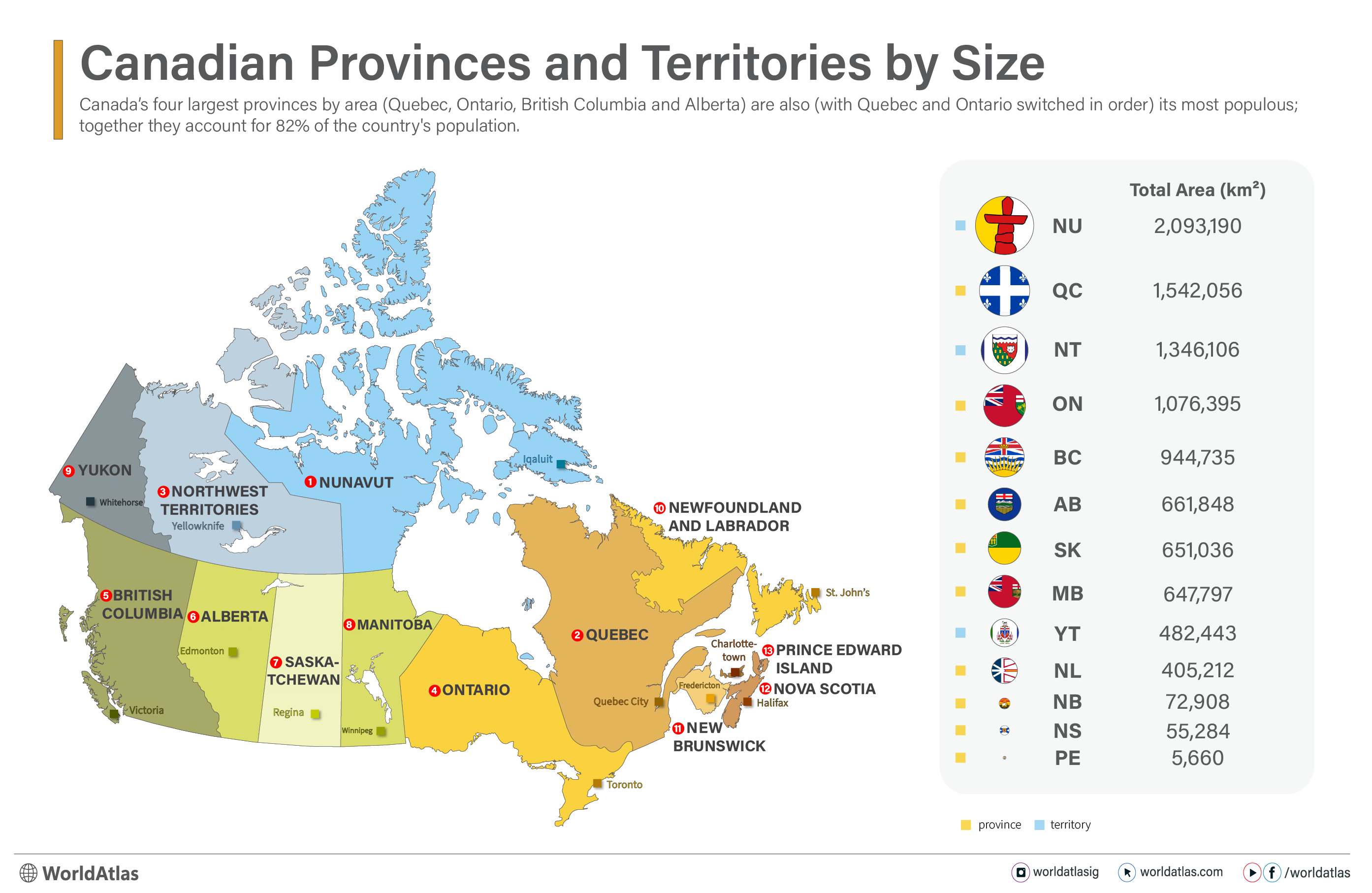
Quebec is the largest province of Canada, and Nunavut is the largest territory.
The Largest And Smallest Provinces Of Canada
Quebec is the largest province in the country, occupying 15.4% of the country’s total area. Its land area is 1,356,128 km2 (523,603.95 mi2), while its water area is 185,928 km2 (71,787.2 mi2), and its total area is 1,542,056 km2 (595,442.88 mi2).
The second-largest province is Ontario, which accounts for 10.8% of the nation’s total area. The province’s land and water areas are 917,741 km2 and 158,654 km2 (354,341.78 mi2 and 61,256.65 mi2), respectively, while the total area is 1,076,395 km2 (415,598.43 mi2).
British Columbia, occupying 9.5% of the country’s total area, is the third-largest province. Its land area is 925,186 km2 (35,7216.3 mi2) while its water area is 19,549 km2 (7547.91 mi2), and its total area is 944,735 km2 (364764.22 mi2).
Prince Edward Island is the smallest province, and it accounts for a mere 0.1% of the country’s entire area. The province has a total area of 5,660 km2 (2185.3 mi2), all of which is land area.
Nova Scotia is the second smallest province with a total area of 55,284 km2 (21345.27mi2). The land’s area is 53,338 km2 (20,593.9 mi2) while its water area is 1,946 km2 (751.35 mi2).
The Territories Of Canada By Size
Nunavut is the country’s largest territory, accounting for 21.0% of the country's total land area. The territory’s total area is 2,093,190 km2 (808,185.17 mi2), divided between land (1,936,113 km2 / 747537.4 mi2) and water (157,077 km2 / 60,647.76 mi2).
The Northwest Territories occupies 13.0% of the country’s land area with a total area of 1,346,106 km2 (519,734.43 mi2). The territory’s land area is 1,183,085 km2 (456,808.27 mi2), while the water area is 163,021 km2 (62,942.75 mi2).
The smallest territory is the Yukon, with a total area of 482,443 km2 (186272.28 mi2) and a 4.8% share of the national land area. The territory’s land area is 474,391 km2 (183163.4 mi2), while the water covers an area of 8,052 km2 (3108.9 mi2).
| Province/Territory | Capital | Area (km2) |
|---|---|---|
| Nunavut | Iqaluit | 2,093,190 |
| Quebec | Quebec City | 1,542,056 |
| Northwest Territories | Yellowknife | 1,346,106 |
| Ontario | Toronto | 1,076,395 |
| British Columbia | Victoria | 944,735 |
| Alberta | Edmonton | 661,848 |
| Saskatchewan | Regina | 651,036 |
| Manitoba | Winnipeg | 647,797 |
| Yukon | Whitehorse | 482,443 |
| Newfoundland and Labrador | St. John's | 405,212 |
| New Brunswick | Fredericton | 72,908 |
| Nova Scotia | Halifax | 55,284 |
| Prince Edward Island | Charlottetown | 5,660 |
Provinces Ranked by Size
| Province | Capital | Area (km2) |
|---|---|---|
| Quebec | Quebec City | 1,542,056 |
| Ontario | Toronto | 1,076,395 |
| British Columbia | Victoria | 944,735 |
| Alberta | Edmonton | 661,848 |
| Saskatchewan | Regina | 651,036 |
| Manitoba | Winnipeg | 647,797 |
| Newfoundland and Labrador | St. John's | 405,212 |
| New Brunswick | Fredericton | 72,908 |
| Nova Scotia | Halifax | 55,284 |
| Prince Edward Island | Charlottetown | 5,660 |
1. Quebec - 1,542,056 km2

Quebec, Canada's largest province by area, stands out with its distinct French heritage, language, and culture. Located in eastern Canada, this province of 9,056,044 is bordered by Ontario to the west, the Atlantic Ocean to the east, the U.S. states of New York, Vermont, New Hampshire, and Maine to the south, and extensive borders with Labrador to its east and New Brunswick to its southeast.
Quebec City, the provincial capital, draws many visitors to its historic sites like the Old Quebec part of the city, a UNESCO World Heritage site. Montreal, its largest city by population, is a notable cultural hub. Quebec's economy thrives primarily on industries like aerospace, technology, and hydropower, alongside a rich tourism sector.
The province features a number of diverse landscapes, from the Laurentian Mountains and forests to the St. Lawrence River.
2. Ontario - 1,076,395 km2

Ontario, Canada's most populous province, with a population of 16,124,116, is a primarily English-speaking province, and it is notable for its major economic influence, cultural diversity, and natural beauty. Located in central Canada, it borders Manitoba to the west, Quebec to the east, the United States to the south (Minnesota, Michigan, New York, Pennsylvania, and Ohio), and Hudson Bay to the north.
Toronto, its capital and largest city (both in the province and Canada as a whole), is a global financial and cultural center. Ottawa, Canada’s capital, is also located in Ontario, featuring iconic landmarks like Parliament Hill. Ontario’s economy thrives on manufacturing, technology, finance, and agriculture, while its parks and urban centers attract millions of visitors annually as well.
The province is home to most of the Great Lakes, Niagara Falls, and vast and sparsely populated wilderness areas to its north.
3. British Columbia - 944,735 km2
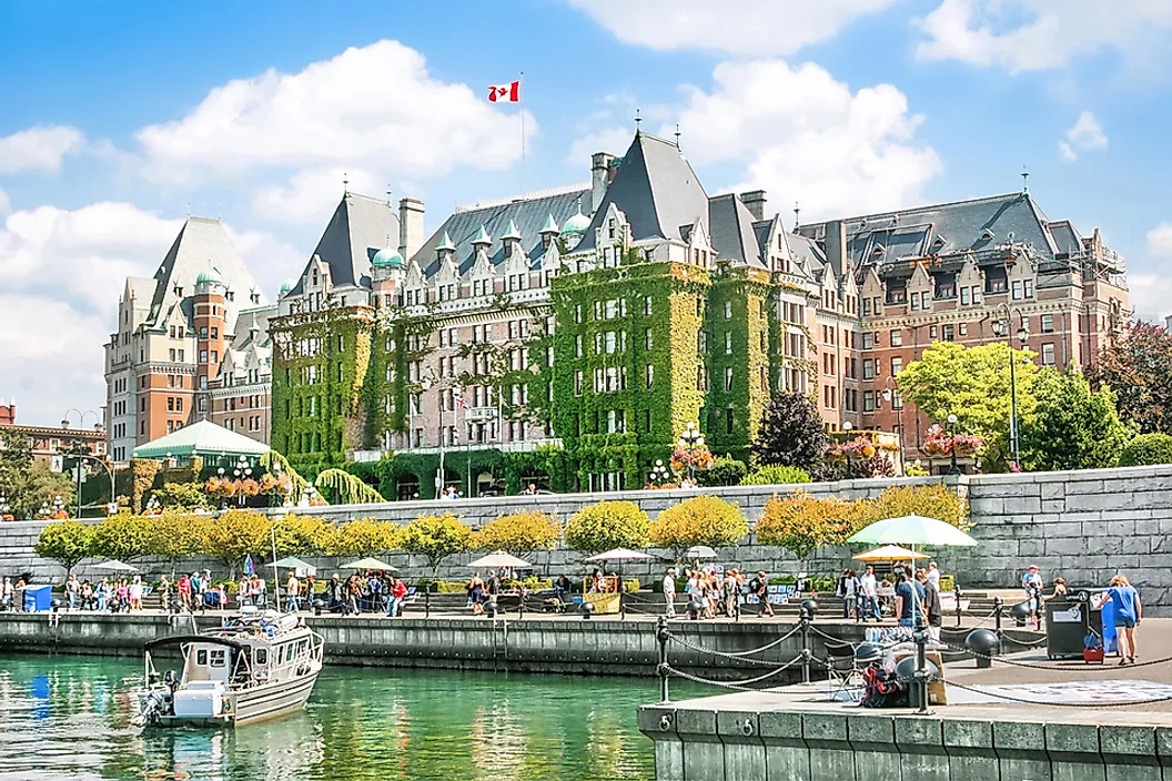
British Columbia, Canada’s westernmost province, is perhaps best known for its mountainous landscapes and abundance of opportunities for outdoor activity throughout the year. With a population of 5,698,430, it stretches from the Pacific Ocean on its west to the Rocky Mountains on its east, including coastal rainforests, alpine peaks, and fertile valleys. It borders Alberta to its east, the Pacific Ocean and Alaska to its west, Yukon and Northwest Territories to its north, and the states of Washington, Idaho, and Montana to its south.
The provincial capital is Victoria, while Vancouver, its largest city, serves as a major cultural and economic hub. British Columbia’s economy is driven by industries such as forestry, mining, film production, and tech. It is a mainly English-speaking province.
Outdoor enthusiasts are drawn to its national parks like Yoho, Kootenay, Pacific Rim, and many more, ski resorts like Whistler, and rugged yet temperate coastline.
4. Alberta - 661,848 km2

Alberta, located in western Canada, is renowned for its expansive prairies, the eastern half of the Canadian Rocky Mountains, and bustling oil and gas industry. Alberta's 4,888,723 residents primarily speak English. The province borders British Columbia to its West, Saskatchewan to its east, Northwest Territories to its north, and the state of Montana to its south.
The province’s two major cities, Edmonton, the provincial capital, and Calgary, its major economic center and home to the second largest amount of corporate headquarters in the nation (behind Toronto), along with famous events like the Calgary Stampede.
Alberta’s landscapes are a huge attraction for tourists as well and include iconic natural wonders like Banff and Jasper National Parks, known for their turquoise glacial lakes and beautiful peaks.
5. Saskatchewan - 651,036 km2

Saskatchewan is best known as a province that highly revolves around agriculture, which makes sense given its expansive landscapes of prairies and grasslands. As you can imagine, the province’s economy is rooted in farming, but also potash mining and energy production. It is an English-speaking province with 1,239,865 residents. It borders Alberta to its west, Manitoba to its east, Northwest Territories to its north, and Montana and North Dakota to its south.
Regina, the capital, is home to the Royal Saskatchewan Museum and an iconic legislative building, while Saskatoon, the largest city, features modern attractions like the Remai Modern Art Museum.
Although stereotyped for its vast, golden, and flat prairies, Saskatchewan’s northern half includes around 94,000 lakes, huge swathes of dense forest, and even a section of the Canadian Shield, making it ideal for outdoor recreation like fishing, hiking, cottaging, and camping.
6. Manitoba - 647,797 km2

Manitoba stretches from Canada's central prairie grasslands to boreal forests and Arctic tundra to its northern borders. It currently has 1,494,301 residents and borders Ontario and the Hudson Bay to its east, Saskatchewan to its west, Nunavut to its north, and North Dakota and Minnesota to its south.
Winnipeg, the provincial capital, is its main cultural and economic hub and is home to landmarks such as the Canadian Museum for Human Rights, and the Forks, a greenspace and market located at the confluence of the Assiniboine and the Red Rivers.
Manitoba’s economy is driven by agriculture, energy, and manufacturing, again, mainly in its more southern economic centers like Winnipeg and Brandon. Although it has notable pockets of French speakers, it is officially an English-speaking province.
Natural attractions in Manitoba include Riding Mountain and Wapusk National Parks, where opportunities for wildlife viewing, hiking, and exploring vast wilderness areas abound.
7. Newfoundland and Labrador - 405,212 km2

Newfoundland and Labrador, Canada’s easternmost province, has 545,247 residents and is known for its massive coastlines and unique Atlantic Canadian culture. Labrador shares a land border to the west with Quebec, and the Atlantic surrounds it in all other directions.
The province encompasses the island of Newfoundland and mainland Labrador, separated by the Strait of Belle Isle. The province’s economy relies on fishing, energy, and tourism. Newfoundland and Labrador is an English-speaking province.
St. John’s, the capital, features eye-catching colorful row houses, Signal Hill, and a thriving bar scene. Iconic natural sites on the island of New Foundland include Gros Morne National Park, a UNESCO World Heritage site, and Iceberg Alley, where massive icebergs drift past.
Labrador, located on the mainland, is very sparsely populated and relies primarily on hydro energy production and its military bases for economic activity. Far-flung parks, like Torngat Mountains National Park, also attract outdoor adventures and hunters to its northern, arctic reaches
8. New Brunswick - 72,908 km2

New Brunswick, one of Canada’s eastern Maritime provinces, has 854,355 and is known for its stunning coastal scenery and bilingual culture. It is in fact the only officially bilingual province in Canada, with English and French both widely spoken. It borders Quebec to its north, Nova Scotia and the Bay of Fundy to its south, the Gulf of St. Lawrence to its east, and the state of Maine to its west.
Fredericton, the capital, features well-known sites like the Beaverbrook Art Gallery, while Saint John and Moncton serve as major urban centers. Forestry, fishing, and tourism are key economic drivers here.
New Brunswick’s forests, rivers, and historic sites make it a destination for outdoor enthusiasts and history lovers alike. The Bay of Fundy, the bay with the highest tides in the world, is located on the southern coast of the province and also contains wonderful landmarks like the Hopewell Rocks (also called the Flowerpot Rocks).
9. Nova Scotia - 55,248 km2
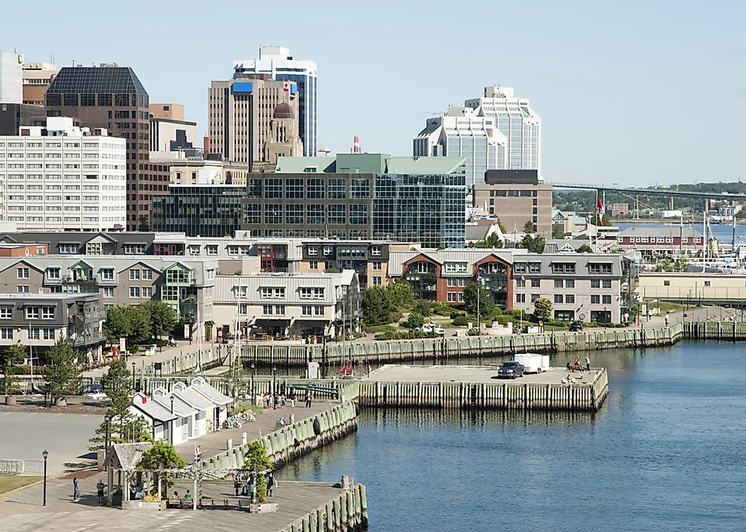
Nova Scotia, another Maritime province in eastern Canada, is almost completely surrounded by the Atlantic Ocean, boasting over 7,500 kilometers of coastline, dotted with fishing villages and nautical landmarks like Peggy’s Cove. It has a population of 1,076,374 and only shares a land border with New Brunswick to its northwest, with the rest of its borders being made up of Atlantic coastline.
Halifax, Nova Scotia's capital, is home to a number of historic attractions, such as the Citadel and Maritime Museum of the Atlantic. Other iconic destinations in Nova Scotia include the Cabot Trail in Cape Breton and the UNESCO World Heritage site of Lunenburg.
The province’s economy is supported heavily by fishing, shipbuilding, and tourism, and English is its primary language.
10. Prince Edward Island - 5,660 km2

Prince Edward Island (PEI), is by far Canada’s smallest province. it is renowned for its red soil, potatoes, and maritime charm. Located in the Gulf of St. Lawrence, PEI is connected to the mainland by the Confederation Bridge (coming out of New Brunswick), Canada's largest bridge. It is the home of 178,550 residents, and as an island, is completely surrounded by the Atlantic Ocean.
Charlottetown, the island province's capital of this maritime province, is known as the “Birthplace of Confederation” for hosting the 1864 Charlottetown Conference, where the British-held provinces of Canada officially decided to unionize and become a self-governing country. PEI’s landscapes have also inspired notable literature, such as Anne of Green Gables, drawing visitors to the town of Cavendish and Green Gables Heritage Place.
The island’s economy thrives on agriculture, especially potato farming, alongside fishing and tourism. It is an English-speaking province. With warm beaches and a number of popular festivals, PEI may be small but holds a special place in the hearts of Canadians.
Territories Ranked by Size
| Territory | Capital | Area (km2) |
|---|---|---|
| Nunavut | Iqaluit | 2,093,190 |
| Northwest Territories | Yellowknife | 1,346,106 |
| Yukon | Whitehorse | 482,443 |
1. Nunavut - 2,093,190 km2

Nunavut, Canada’s northernmost territory, is known for its vast, arctic landscapes and Indigenous Inuit culture. Established in 1999, it spans over 2 million square kilometers, encompassing most of Canada’s Arctic Archipelago and part of the mainland, making it the single largest governed region of Canada. It borders Northwest Territories to its west, and Manitoba to its south. Even with its sheer size, it is only home to 41,159 residents.
Iqaluit, the territory's capital, is located on Baffin Island and serves as the political and economic center. Nunavut’s economy revolves around natural resource extraction, including mining and fishing, along with a growing tourism sector. Its few residents speak either their native language or English.
The territory's remote communities are almost all connected by sea and air, with stunning natural sights like glaciers, icebergs, and the Northern Lights interspersed throughout.
2. Northwest Territories - 1,346,106 km2

The Northwest Territories, located in northern Canada, is another territory known for its vast wilderness and rich Indigenous cultures. It encompasses the most northern peaks of the Rocky Mountains, freshwater lakes like the enormous Great Slave Lake, and swathes of boreal forests.
Northwest Territories has a population of 44,731, slightly edging out its eastern neighbor, Nunavut. It borders Yukon to its west and British Columbia, A,lberta, and Saskatchewan to its south and the artic to the north.
Yellowknife, the capital, is Northwest Territories' administrative center, with a growing tourism scene and proximity to the Nahanni National Park, a UNESCO World Heritage site.
The economy here is driven by mining, energy, and tourism, particularly for those seeking outdoor adventures such as fishing, hiking, and viewing the Northern Lights. Indigenous culture remains integral to the territory’s identity, with native languages spoken here alongside English.
3. Yukon - 482,443 km2

Likely Canada's most well-known territory, Yukon, located in the far north of the country, is also its smallest in landmass. It is, however, the most populous territory, with 46,704 residents.
This territory, bordered by Alaska to the west, Northwest Territories to its east, and British Columbia to its south, is famous for its mountainous landscapes, including the towering peaks of the Ogilvie Mountains and the vast tundra of the Dempster Highway. Its economic history, closely associated with the Canadian Gold Rush in the Klondike region in the late 19th century, has often put it in popular media too.
Today, the economy is driven by mining, tourism, and energy, with natural beauty and a rich Indigenous heritage shaping its unique character. English is Yukon's primary language, although native languages are also commonly spoken.
Whitehorse is Yukon's capital and serves as a gateway to the bulk of the outdoor adventures and cultural experiences that can be found here. Other notable towns, such as Dawson City, allow visitors to explore Yukon's remote wilds and interesting gold-laden past up close.
Explore Canada's Diverse Territories and Provinces
With Nunavut standing as Canada's largest singular region, and Prince Edward Island, a mere fraction of the size and the country's smallest province by a long shot, there is a huge variety of landscapes and cultures to be found here.
The second biggest country in the world at nearly 9.9 million square kilometers, Canada is unique with its two official languages (English and French) and distant yet highly modern, world-class cities. From Vancouver to St. John's, the 10 provinces and 3 territories that lay within Canada's borders make for endless amounts of exploration and economic opportunities for Canadian residents and visitors alike.