Largest Counties In The US By Area
- San Bernardino County in California is the largest county in the United States
- The 10 largest counties are all bigger in size than the state of Vermont.
- Area 51 is found in Lincoln County, Nevada, with a population of just over 5,000 people.
Quick geography trivia: the largest county in the United States is a slab of Alaska the size of Montana with about 5,000 people in it. The Yukon-Koyukuk Census Area stretches across roughly 147,000 square miles, and the next eight biggest county-equivalents are Alaskan too. Here is the catch. Alaska does not actually have counties. It runs on boroughs and census areas instead, so by the strict letter of the word, the title passes to the Lower 48, where San Bernardino, California, takes the crown at 20,105 square miles. Every county on this list, ranked by total area, is out West. Every one is bigger than Vermont. Several are bigger than small countries, and a few are mostly federal land, empty desert, or restricted airspace nobody will officially confirm. Here are the ten largest, with Alaska's giants politely set aside.
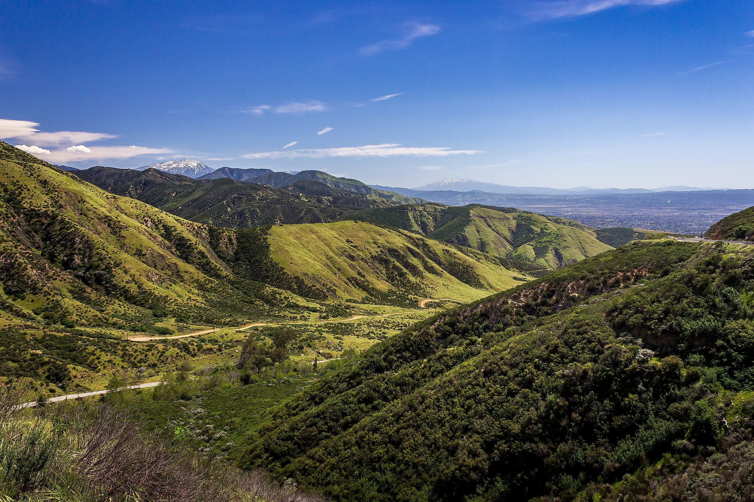
1. San Bernardino, California (20,105 square miles)

San Bernardino is the largest true county in the country, 20,105 square miles of mostly wide-open Southern California. To put that in perspective, it is bigger than nine US states and roughly the size of Croatia. The county and its mountains took their name from an early mission chapel, but very little of it is city. Most is the Mojave Desert, mountain wilderness, and protected land that wildfire and drought regularly threaten. Its 2.2 million residents pack into the San Bernardino and Victor Valleys in the southwestern corner, which makes it the fifth-most-populous county in California. The rest is room to spread out.
2. Coconino, Arizona (18,661 square miles)

Coconino County covers 18,661 square miles of northern Arizona, and its headline tenant is the Grand Canyon. The name traces back to Cohonino, an old word for the Havasupai people who have lived in and around the canyon for centuries. It is one of the most heavily Indigenous counties on this list, with land held by the Navajo, Havasupai, Hualapai, and Hopi nations across five reservations. Flagstaff anchors a population of about 145,000, but the county is really a stack of high plateaus, ponderosa pine forest, and the most famous hole in the ground on Earth.
3. Nye, Nevada (18,159 square miles)

Nye County spans 18,159 square miles, making it the largest in Nevada and third on this list. It is named for James W. Nye, the Nevada Territory's first governor and later a US senator. Gold built its early economy; the modern attractions are stranger. They include the Nevada Test Site, where the government detonated hundreds of nuclear weapons, and the surreal spring-fed pools of Ash Meadows National Wildlife Refuge, home to fish found nowhere else on the planet. With roughly 50,000 people scattered across an area larger than several states, Nye has plenty of space to keep to itself.
4. Elko, Nevada (17,203 square miles)

Elko County, 17,203 square miles in Nevada's northeastern corner, is so big it cannot agree with itself on what time it is. Most of the county runs on Pacific Time, but a cluster of communities near the state line, including Jackpot, Jarbidge, and Mountain City, keep Mountain Time to stay in step with the Idaho towns they actually do business with. Clock confusion aside, Elko has the Ruby Mountains, the Humboldt-Toiyabe National Forest, and the Ruby Lake National Wildlife Refuge. Around 53,000 people call it home.
5. Mohave, Arizona (13,470 square miles)

Mohave County covers 13,470 square miles of northwestern Arizona, up in the corner where Arizona, Nevada, and Utah all meet. Kingman is the county seat, and the county wraps around Lake Mead, a stretch of the Grand Canyon, and the gloriously remote Grand Canyon-Parashant National Monument, a place so undeveloped it has been designated a dark-sky destination. About 213,000 people live here, many strung along the Colorado River, and the Hualapai, Kaibab Paiute, and Fort Mojave nations hold reservation land within its borders.
6. Apache, Arizona (11,218 square miles)

Apache County is a tall, narrow ribbon of eastern Arizona, 11,218 square miles running the length of the New Mexico border. Most of it is Navajo Nation land, and its population of about 66,000 is heavily Indigenous. For its size it packs in a remarkable run of landmarks: the rainbow-colored logs of Petrified Forest National Park, the ancient cliff dwellings of Canyon de Chelly National Monument, and the still-operating Hubbell Trading Post, the oldest of its kind on the Navajo Nation. St. Johns, the county seat, sits down near the bottom of the strip.
7. Lincoln, Nevada (10,637 square miles)

Lincoln County covers 10,637 square miles of eastern Nevada and is named, like a great deal else from the 1860s, for President Lincoln. Its population is around 5,200, but its most famous resident is not a person at all. Area 51, the secret Air Force base the government refused to officially acknowledge until 2013, sits within the county. The county seat is Pioche, a former silver boomtown so rowdy in its heyday that, by local legend, dozens of men filled its cemetery by gunfire before anyone there died of natural causes. More than a dozen designated wilderness areas fill out the rest.
8. Sweetwater, Wyoming (10,491 square miles)

Sweetwater County, 10,491 square miles in southwestern Wyoming, is larger than Rhode Island, Delaware, and Connecticut put together. It takes its name from the Sweetwater River, which, improbably for high desert Wyoming, eventually drains to the Gulf of Mexico by way of the Platte, the Missouri, and the Mississippi. This is high, dry sagebrush country dotted with ghost towns like Bryan and Winton, with a population around 42,000 centered on Rock Springs and Green River and a long history tied to coal, trona mining, and the transcontinental railroad.
9. Inyo, California (10,227 square miles)

Inyo County holds the most extreme terrain on the entire list. Inside its 10,227 square miles sits Badwater Basin in Death Valley, the lowest point in North America at 282 feet below sea level and one of the hottest places on Earth. Along its western boundary rises Mount Whitney, the highest point in the contiguous United States at 14,505 feet. The lowest and highest ground in the Lower 48 sit barely 80 miles apart, both touching this single county. About 18,000 people live in the country in between, governed from the small county seat of Independence. The name is thought to come from a Native American word for the region.
10. Harney, Oregon (10,226 square miles)

Harney County closes out the top ten at 10,226 square miles, the largest county in Oregon and a hair smaller than Inyo. It was named in 1889 for the army general William S. Harney, and with a population near 7,300 it is one of the emptiest counties in the West, ranch country where cattle comfortably outnumber people. Its centerpiece is Steens Mountain, a mile-high fault block towering over the surrounding high desert, alongside the wetlands of the Malheur National Wildlife Refuge and mile after mile of open range.
The 30 Largest Counties in the Lower 48
Stretch the ranking past the top ten and the pattern holds. Here are the thirty largest counties by total area, again with Alaska's much larger boroughs and census areas left out. Almost every one is in the West, the lone exception being Minnesota's St. Louis County around Duluth, which slips in at number 30.
| Rank | County | State | Total Area (sq mi) |
|---|---|---|---|
| 1 | San Bernardino County | California | 20,105.32 |
| 2 | Coconino County | Arizona | 18,661.21 |
| 3 | Nye County | Nevada | 18,158.73 |
| 4 | Elko County | Nevada | 17,202.94 |
| 5 | Mohave County | Arizona | 13,469.71 |
| 6 | Apache County | Arizona | 11,218.42 |
| 7 | Lincoln County | Nevada | 10,636.77 |
| 8 | Sweetwater County | Wyoming | 10,491.17 |
| 9 | Inyo County | California | 10,226.98 |
| 10 | Harney County | Oregon | 10,226.49 |
| 11 | Navajo County | Arizona | 9,959.49 |
| 12 | Malheur County | Oregon | 9,929.99 |
| 13 | Humboldt County | Nevada | 9,657.87 |
| 14 | Fremont County | Wyoming | 9,265.80 |
| 15 | Maricopa County | Arizona | 9,224.27 |
| 16 | Pima County | Arizona | 9,188.83 |
| 17 | White Pine County | Nevada | 8,896.60 |
| 18 | Idaho County | Idaho | 8,502.48 |
| 19 | Lake County | Oregon | 8,358.47 |
| 20 | Kern County | California | 8,161.42 |
| 21 | Yavapai County | Arizona | 8,127.78 |
| 22 | Clark County | Nevada | 8,090.66 |
| 23 | Carbon County | Wyoming | 7,964.03 |
| 24 | San Juan County | Utah | 7,933.09 |
| 25 | Owyhee County | Idaho | 7,696.71 |
| 26 | Riverside County | California | 7,303.13 |
| 27 | Tooele County | Utah | 7,287.12 |
| 28 | Park County | Wyoming | 6,968.51 |
| 29 | Catron County | New Mexico | 6,929.03 |
| 30 | St. Louis County | Minnesota | 6,859.91 |
Room to Spare
The pattern here is not subtle. Draw a county across the 19th-century West, where your nearest neighbor might be 50 miles off, and you end up with these enormous, near-empty rectangles. Nine of the ten are desert or high country, most are largely federal land, and several dwarf entire states back East. And remember, this whole ranking is the consolation bracket. If Alaska simply called its boroughs and census areas "counties," San Bernardino would not even make the top ten. The Lower 48 gets to brag here only on a technicality.