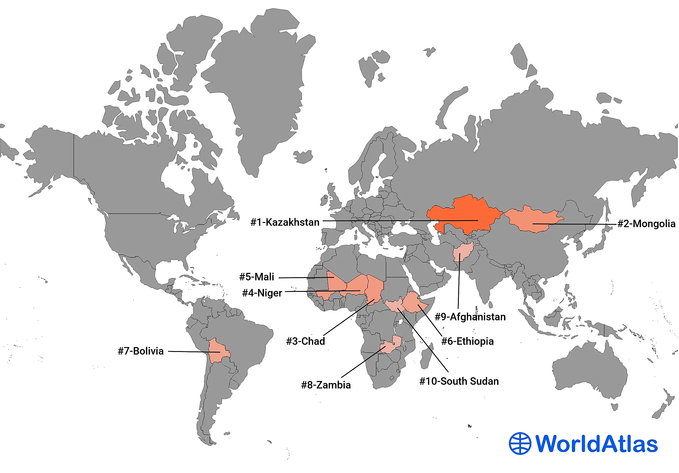
Largest Landlocked Countries In The World
A landlocked country is one with no coastline and no direct route to the open ocean, which sounds like a minor inconvenience until you try to run an export economy through someone else's ports. There are 44 of them, and two, Uzbekistan and Liechtenstein, are so thoroughly hemmed in that you have to cross two international borders just to reach salt water. Being landlocked does have its upsides: no coastline means no hurricanes coming in off the sea, no tsunamis, and no navy to fund. The downsides are the ones that sting, since every imported and exported good has to travel overland through a neighbor, which means higher costs, more customs paperwork, and a permanent incentive to stay on good terms with whoever controls the nearest coast. The ten below are the biggest of the bunch, ranked by land area.
1. Kazakhstan - 2,724,900 km²

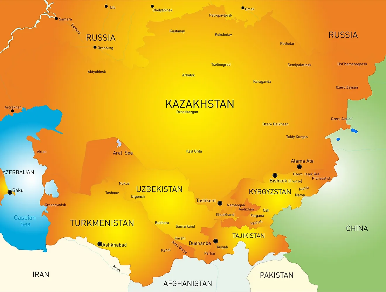
Kazakhstan is not just the largest landlocked country on earth, it is the ninth-largest country of any kind, bigger than all of Western Europe combined, and it does it without a single seaport. It does touch the Caspian Sea, but that is a technicality the geography refuses to honor: the Caspian is fully enclosed, with no outlet to the ocean, which makes it the world's largest lake and leaves Kazakhstan as landlocked as ever. Around 20.6 million people share all that room with a great deal of open steppe. The country borders Russia, China, Kyrgyzstan, Uzbekistan, and Turkmenistan, and anchors Central Asia.
2. Mongolia - 1,564,116 km²

Mongolia is the most sparsely populated sovereign country in the world, with only about two people per square kilometer. Its 3.5 million residents are wedged between exactly two neighbors, Russia to the north and China to the south, with no third border in sight. All that space and so few people have helped keep a nomadic herding culture alive here longer than almost anywhere else, and much of the country is still open steppe and desert rather than city.
3. Chad - 1,284,000 km²

Chad takes its name from Lake Chad, the shallow, shrinking body of water at its southwestern corner that also names the vast basin around it. The country sits squarely in the middle of the continent, its northern half reaching deep into the Sahara and its south easing into savanna where most of the roughly 19 million residents live. Chad borders six countries: Libya, Sudan, the Central African Republic, Cameroon, Nigeria, and Niger.
4. Niger - 1,267,000 km²

Niger is mostly desert, with the Sahara blanketing the northern two-thirds of the country and nearly everyone living in the greener south. It is named for the Niger River, which clips only the southwestern corner near the capital, Niamey, before curving off into other countries entirely. With about 27 million people and one of the highest birth rates on record, Niger is growing quickly. It shares borders with seven nations: Algeria, Libya, Chad, Nigeria, Benin, Burkina Faso, and Mali.
5. Mali - 1,240,192 km²

Mali is home to Timbuktu, which is worth a pause: the city English speakers invoke as shorthand for the most far-flung place imaginable is a real town in central Mali, and it was once a legendary hub of gold, salt, and scholarship on the Saharan trade routes. The country was the heart of the medieval Mali Empire, whose emperor Mansa Musa is frequently named the wealthiest individual in recorded history. Today around 24 million people live here, and Mali borders seven countries: Algeria, Mauritania, Senegal, Guinea, Cote d'Ivoire, Burkina Faso, and Niger.
6. Ethiopia - 1,104,300 km²

Ethiopia is the most populous landlocked country in the world by a wide margin, home to roughly 130 million people. It has not always been landlocked, either: the country held a Red Sea coastline until 1993, when Eritrea became independent and the shoreline went with it, leaving Ethiopia to route its sea trade through neighboring Djibouti. It borders six countries: Eritrea, Djibouti, Somalia, Kenya, South Sudan, and Sudan.
7. Bolivia - 1,098,581 km²

Bolivia is the only country on this list outside Africa and Asia, and it did not begin landlocked. It lost its Pacific coastline to Chile in the War of the Pacific in the 1880s, and it has never quite let the matter go. The country still maintains a navy, several thousand sailors strong, which patrols Lake Titicaca and the inland rivers and turns out in force every year for the Day of the Sea. Bolivia also runs two capitals, Sucre and La Paz, and is home to about 12 million people. It borders Brazil, Peru, Chile, Argentina, and Paraguay.
8. Zambia - 752,618 km²

Zambia sits in Southern Africa and holds this list's record for most neighbors, sharing borders with eight countries: the Democratic Republic of the Congo, Tanzania, Malawi, Mozambique, Zimbabwe, Botswana, Namibia, and Angola. Its southern edge is drawn by the Zambezi River, which drops over Victoria Falls along the border with Zimbabwe. About 21 million people live in Zambia.
9. Afghanistan - 652,230 km²

Afghanistan is a rugged, mountainous country in South-Central Asia, dominated by the Hindu Kush range. One of its odder features is the Wakhan Corridor, a narrow finger of land in the northeast that stretches nearly 200 miles east until it just barely touches China. It was drawn deliberately in the 19th century as a buffer between the British and Russian empires, specifically so the two would never share a border here. Afghanistan is home to roughly 42 million people and borders six countries: Pakistan, Iran, Turkmenistan, Uzbekistan, Tajikistan, and China.
10. South Sudan - 644,329 km²

South Sudan rounds out the list as both the tenth-largest landlocked country and the newest country in the world, having gained independence from Sudan in July 2011. It lies in East-Central Africa, drained by the White Nile and its tributaries, and shares borders with six countries: Sudan, Ethiopia, Kenya, Uganda, the Democratic Republic of the Congo, and the Central African Republic. Its population is estimated at around 11 million.
All 44 Landlocked Countries By Area
The complete ranking of every landlocked country by land area, in square kilometers:
| Rank | Country | Area (km²) |
|---|---|---|
| 1 | Kazakhstan | 2,724,900 |
| 2 | Mongolia | 1,564,116 |
| 3 | Chad | 1,284,000 |
| 4 | Niger | 1,267,000 |
| 5 | Mali | 1,240,192 |
| 6 | Ethiopia | 1,104,300 |
| 7 | Bolivia | 1,098,581 |
| 8 | Zambia | 752,618 |
| 9 | Afghanistan | 652,230 |
| 10 | South Sudan | 644,329 |
| 11 | Central African Republic | 622,984 |
| 12 | Botswana | 581,730 |
| 13 | Turkmenistan | 488,100 |
| 14 | Uzbekistan | 447,400 |
| 15 | Paraguay | 406,752 |
| 16 | Zimbabwe | 390,757 |
| 17 | Burkina Faso | 274,200 |
| 18 | Uganda | 241,038 |
| 19 | Laos | 236,800 |
| 20 | Belarus | 207,600 |
| 21 | Kyrgyzstan | 191,951 |
| 22 | Nepal | 147,181 |
| 23 | Tajikistan | 144,100 |
| 24 | Malawi | 118,484 |
| 25 | Hungary | 93,028 |
| 26 | Azerbaijan | 86,600 |
| 27 | Austria | 83,871 |
| 28 | Czech Republic | 78,867 |
| 29 | Serbia | 77,474 |
| 30 | Slovakia | 49,035 |
| 31 | Switzerland | 41,277 |
| 32 | Bhutan | 38,394 |
| 33 | Moldova | 33,851 |
| 34 | Lesotho | 30,355 |
| 35 | Armenia | 29,743 |
| 36 | Burundi | 27,830 |
| 37 | Rwanda | 26,338 |
| 38 | North Macedonia | 25,713 |
| 39 | Eswatini | 17,364 |
| 40 | Luxembourg | 2,586 |
| 41 | Andorra | 468 |
| 42 | Liechtenstein | 160 |
| 43 | San Marino | 61 |
| 44 | Vatican City | 0.44 |