The Most Tornado-Prone States in the US
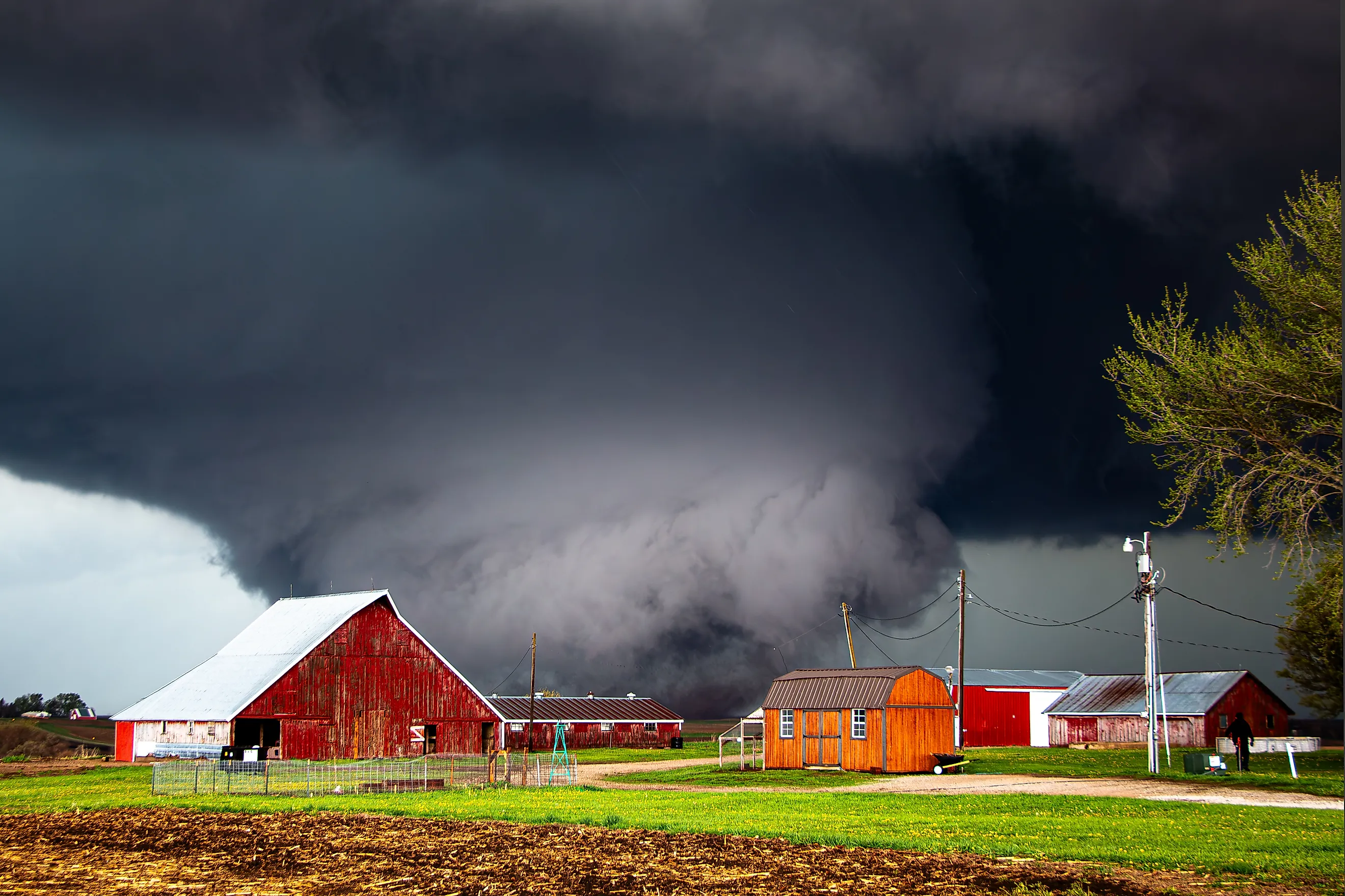
More than a thousand tornadoes touch down across the United States in a typical year, more than any other country on Earth records. The reason is a collision that happens nowhere else at this scale. Warm, moist air streams north off the Gulf of Mexico and runs into cold, dry air sliding down from Canada and the Rockies. Over the open Plains, that clash builds the rotating supercell thunderstorms that drop funnels. The damage adds up to billions of dollars and roughly 70 deaths in an average year. For families across the middle of the country, a siren in the distance is simply part of the spring.
The map of risk is also shifting. Researchers have tracked tornado activity easing away from the traditional Plains and into the Southeast over recent decades, pushing the threat toward areas that are more wooded, more crowded, and harder to see a storm coming across. The ten states below record the highest tornado counts year after year. The yearly averages that order this list shift with the data window and the source, so treat the figures as a guide to relative risk rather than a fixed score.
The 10 Most Tornado-Prone States in the US
| Rank | State | Yearly Avg Tornadoes |
|---|---|---|
| 1 | Texas | 124 |
| 2 | Kansas | 87 |
| 3 | Oklahoma | 66 |
| 4 | Mississippi | 64 |
| 5 | Alabama | 63 |
| 6 | Illinois | 57 |
| 7 (tie) | Missouri | 53 |
| 7 (tie) | Iowa | 53 |
| 9 (tie) | Florida | 46 |
| 9 (tie) | Minnesota | 46 |
1. Texas

Texas records more tornadoes than any other state, and the margin over second place is wide. Most of the activity concentrates across the Panhandle and the northeastern corner, where dry air and Gulf moisture meet most often. The danger in Texas is partly a matter of where the storms land. Large metros like Dallas, Fort Worth, and Houston sit inside the state's tornado corridors and have taken hits since the start of reliable record-keeping.
The deadliest day came on May 11, 1953, when an F5 tornado tore through downtown Waco. It killed 114 people, injured close to 600, and demolished some 1,600 buildings and more than 2,000 vehicles. It was the first tornado officially rated F5 in the United States, and the destruction helped push the country toward the national weather warning systems in use today.
2. Kansas

No state is more closely tied to the tornado in the public imagination, thanks largely to a Kansas farmhouse lifted into the air in "The Wizard of Oz." Kansas sits at the center of Tornado Alley, and its central and western plains record some of the densest tornado counts anywhere, helped by flat ground that gives a storm nothing to slow it down. Powerful EF5 funnels have struck both farm country and larger cities such as Wichita and Topeka. Sirens cover the state, and reinforced safe rooms turn up even in modest single-story homes.
Greensburg is the case most Kansans point to. On the evening of May 4, 2007, an EF5 with winds estimated above 205 mph destroyed roughly 95 percent of the town in a matter of minutes. Greensburg rebuilt itself as one of the greenest small towns in the country, running largely on wind power, though its population never returned to what it had been.
3. Oklahoma

Norman is home to the National Weather Center, where much of the country's tornado forecasting is done, and the location is no accident. Oklahoma sees frequent violent EF4 and EF5 storms across its flat terrain, most heavily along the I-35 corridor in the central and northern parts of the state, usually arriving in clusters during major spring outbreaks. The open plains leave little to weaken a funnel, and the growing skylines of Oklahoma City and Tulsa raise the stakes. Newer high-rises are engineered with deep foundations and internal damping to counter the sway in high wind.
Two events stand out. The 1947 Woodward disaster killed 116 people and injured 782. Then, on May 3, 1999, the Bridge Creek-Moore tornado produced a radar reading that a 2021 reanalysis revised to 321 mph, the highest wind speed ever recorded inside a tornado.
4. Mississippi

The flat farmland along the Mississippi River gives long-track funnels room to stay on the ground for miles, and the storms here are among the most dangerous the Southeast produces. Mississippi sees its worst activity across the northern and central counties. This is the core of "Dixie Alley," where tornadoes often strike after dark and catch sleeping families with little warning. With few large cities, the heaviest damage tends to fall on small towns and rural communities.
The state's record runs deep. Beyond the 2011 outbreak, a 1971 F4 killed 58 people and injured nearly 800 in the Issaquena and Grenada area. Cities including Jackson, Tupelo, and Corinth have all taken serious hits over the years.
5. Alabama

Warm air drawn straight off the Gulf of Mexico fuels some of the most violent storms in the country, and Alabama has seen a string of EF4 and EF5 tornadoes in recent decades. The Tennessee Valley and the Appalachian foothills channel storms along well-worn paths, and cities like Birmingham and Huntsville have taken direct hits.
April 27, 2011 remains the date Alabama measures the others against. During the largest tornado outbreak in U.S. history, a high-end EF4 cut through Tuscaloosa and northern Birmingham, while a separate EF5 leveled Hackleburg and Phil Campbell. The day's tornadoes killed more than 200 people in Alabama alone, with around 110 more lost across neighboring states.
6. Illinois

This is the northernmost name on the list, and proof that the threat reaches well into the Midwest. Illinois sees warm and cool air masses clash on a regular basis, producing a steady run of severe thunderstorms and twisters once early summer arrives. Most of the state's tornadoes stay modest in size, but the exceptions have been historic.
The Tri-State Tornado of 1925 crossed through here and remains the deadliest tornado in United States history. It killed 695 people and injured more than 2,000 along a 219-mile track, with southern Illinois bearing the heaviest toll.
7. Missouri

Sitting where the Great Plains meet the Mississippi Valley, Missouri keeps the atmosphere on edge. Humid Gulf air repeatedly meets cooler air coming off the Rockies and the upper Midwest, and the result is a long run of volatile afternoons. The peak runs from April through June, though the state has logged tornadoes in every month.
The worst came on May 22, 2011, when an EF5 struck Joplin, killing 158 people and injuring well over 1,100. At roughly $2.8 billion in damage, it stands as the costliest single tornado in American history. Larger cities such as St. Louis and Kansas City have weathered serious outbreaks as well.
7. Iowa

Tied for seventh, Iowa owes its count to a spot in the central Plains where moisture-laden Gulf air meets drier air arriving from the west and north. Activity peaks from May through July, when strong wind shear and unstable air turn ordinary storms into severe ones. The totals run below Texas or Kansas, yet the state has produced long-track funnels that stay on the ground past 25 miles.
The 2024 season was especially hard, with the town of Greenfield taking a deadly EF4. One small mercy is the landscape itself: a tornado in Iowa often crosses open cornfields rather than dense neighborhoods.
9. Florida

Here is the outlier of the group, a state that posts high tornado numbers without any classic Tornado Alley setup. Florida keeps warm, wet air on hand from both the Gulf of Mexico and the Atlantic. Daily thunderstorms fire up when sea breezes collide, spinning out short-lived twisters almost year-round. Add in landfalling hurricanes and waterspouts coming ashore, and the reports pile up quickly, even if many funnels stay on the weaker end.
When the ingredients do align, the results are deadly. A major outbreak along the I-4 corridor through Central Florida in late February 1998 remains the worst tornado event in state history. The "Groundhog Day" outbreak of February 2, 2007 struck again before dawn, flattening neighborhoods and killing 21 people across Central Florida while most residents slept.
9. Minnesota

Better known for blizzards, Minnesota sits on the northern edge of the Plains tornado belt, and its summers can turn dangerous fast. When humid Gulf air pushes north and meets cold, dry air dropping out of Canada, a strong jet stream can twist ordinary thunderstorms into rotating supercells. The season peaks from June through August, and the flatter farm country in the south and west sees the most activity.
Two dates anchor the state's record. The Twin Cities outbreak of May 6, 1965, remembered as "The Longest Night," sent several strong tornadoes through the metro and surrounding counties. June 17, 2010 then became the biggest single tornado day in modern state history, led by an EF4 that struck the city of Wadena.
What the Map Is Telling Us
The threat is not one thing. On the open Plains of Texas and Kansas it is the classic spring supercell building in the afternoon. Across Mississippi and Alabama, in Dixie Alley, it often arrives at night, when families are asleep and warnings are easiest to miss. In Florida it spins up off the sea breeze in almost any month. What links these ten states is a geography that keeps forcing warm and cold air together, and populations that have learned to live alongside the sirens. The averages and the records describe the danger, but the more useful fact is the one that keeps changing: with activity drifting east into more crowded, more wooded country, knowing your local risk and having a plan for where to shelter matters more than it once did.