The Driest States In The United States
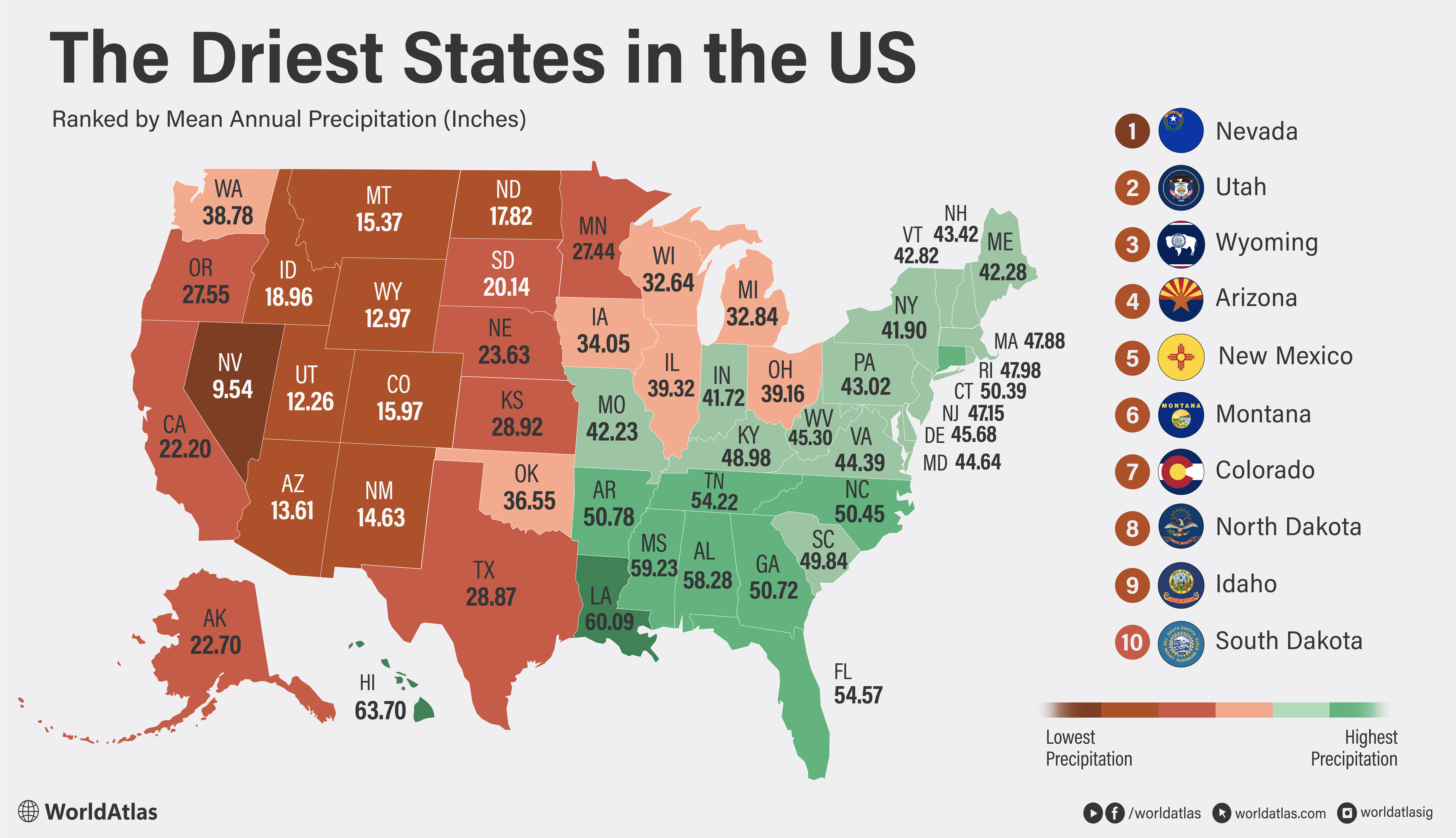
Most of the country gets by on about 30 inches of precipitation a year. Nevada makes do with less than ten. That gap defines the driest states, a run of them stacked across the mountain West and the northern Great Plains where the same forces keep the rain away. Mountains wring the moisture out of Pacific storms, and sheer distance from the ocean starves the interior of what is left. Several of these states are famous for snow, which hides how little water actually reaches the ground. The ranking below uses NOAA's 1991-2020 climate normals, counting rain and the liquid-water equivalent of snow. The middle positions sit within an inch or two of each other, so the order there is closer than the numbers suggest.
1. Nevada - 9.54 in

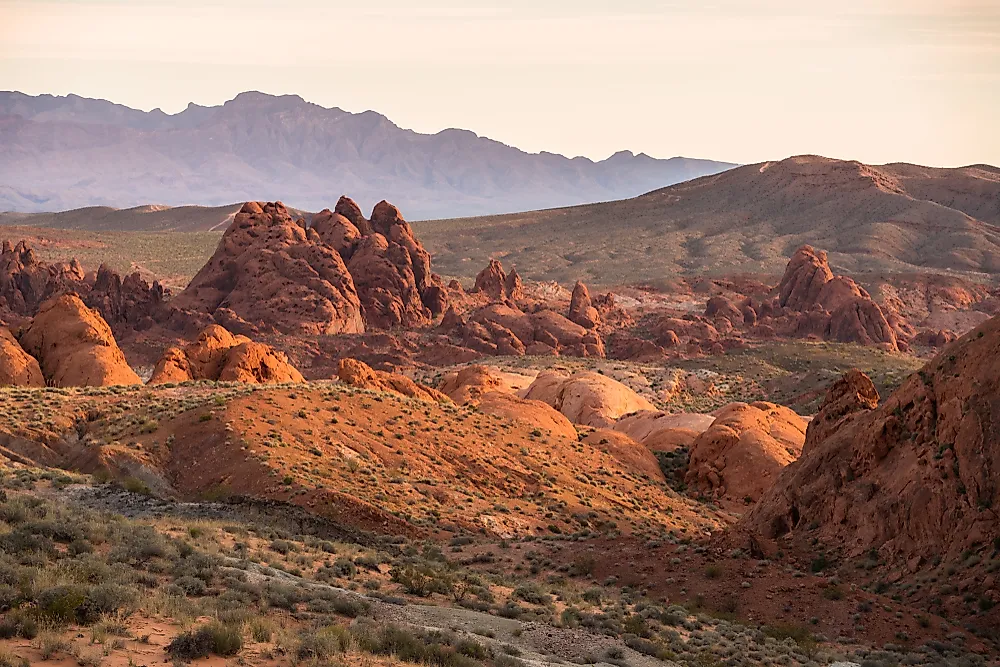
Nevada is the driest state in the country. Its statewide annual precipitation averages about 9.5 inches over the long-term record, the only state below ten inches. Some low-elevation areas in the southwest receive only around four inches during a typical year. High Sierra Nevada peaks can collect more than 50 inches of water through rain and snow.
The contrast comes from Nevada's terrain. Pacific storms release much of their moisture over California's mountains before reaching the Great Basin. Nevada's many enclosed valleys also lack rivers that carry water toward an ocean. Southern and eastern parts of the state sometimes receive summer monsoon storms, but these downpours are irregular. Las Vegas consequently depends heavily on the Colorado River, while the Reno area draws water connected to the Sierra Nevada and Lake Tahoe.
2. Utah - 12.26 in

Utah is the second-driest state, with a statewide average near 12.2 inches. Precipitation across the state is far from uniform. Parts of the Great Salt Lake Desert receive less than five inches annually. Some sections of the Wasatch Mountains collect more than 40 inches. Mountain snowfall supplies many of Utah's rivers and reservoirs, making the timing of snowmelt as important as the total precipitation.
The Great Salt Lake can also generate intense lake-effect snow east and south of its shoreline. Any moist air crossing the continent from the Pacific must first pass over ranges like the Sierra Nevada and the Cascades, which strip out much of its moisture before it reaches the Mountain West. Utah's reputation as a ski destination hides how little rain most of the state actually sees. Statewide annual precipitation has varied between 6.2 inches in 2020 and 20.3 inches in 1941.
3. Wyoming - 12.97 in

Wyoming's cold winters and substantial mountain snow can obscure how dry the state is overall. Its long-term statewide precipitation average is approximately 13 inches, which places it just ahead of the southwestern desert states. Individual monitoring sites range between 5.51 inches in north-central Wyoming and 32.82 inches in Yellowstone National Park.
The state sits deep inside the continent, far from dependable ocean moisture. Mountain ranges intercept passing storms, leaving adjoining basins in pronounced rain shadows. Much of Wyoming's lower terrain is therefore covered by sagebrush steppe and shortgrass prairie. The mountain snowpack remains critical because it stores winter precipitation until spring and summer. Rivers originating in Wyoming eventually supply farms and communities well beyond the state. A low-snow winter can therefore affect downstream water availability even when Wyoming's annual precipitation does not appear exceptionally low.
4. Arizona - 13.61 in

Arizona averages about 13.6 inches of precipitation a year, and much of the state is arid or semiarid. Annual precipitation falls below four inches in parts of the southwestern desert, while the White Mountains can receive around 40 inches. Its aridity reflects an inland position and air masses that lose moisture crossing California and the Great Basin before arriving.
Arizona has two main precipitation seasons. Pacific storm systems bring rain and mountain snow during winter. The North American Monsoon produces localized thunderstorms between late June and September. In southern Arizona, monsoon rainfall can supply more than half of the annual precipitation. Its timing and coverage vary widely, however. One community may experience flash flooding while nearby land remains dry. Arizona's statewide total has ranged between six inches in 1956 and 22.8 inches in 1905, showing how strongly individual years can depart from the average.
5. New Mexico - 14.63 in

New Mexico averages roughly 14.6 inches a year and receives little precipitation for much of it, followed by a short summer period when thunderstorms can deliver a large share of its water. In some regions, North American Monsoon rainfall accounts for half of the annual total. Those storms support rangelands and agriculture, yet their scattered nature makes them unreliable as a statewide water source.
Mountain ranges force moist air upward and create wetter pockets at high elevations. Basins, plains, and desert valleys remain much drier. The statewide annual total has fallen as low as 6.6 inches and risen as high as 26.6 inches. These large swings complicate reservoir management and groundwater planning. Spring is already New Mexico's dry season, and climate projections indicate that spring precipitation may decline across much of the state. Warmer conditions can also remove soil moisture faster between storms.
6. Montana - 15.37 in

Montana's statewide annual precipitation averages around 15.4 inches. Southern valleys and lowlands can receive less than seven inches, placing them firmly within a semiarid climate. Mountainous northwestern Montana receives more than 35 inches, and some high elevations accumulate over 300 inches of snow.
The dry interior reflects Montana's distance from major oceans and the effects of several mountain ranges. Western mountains remove moisture from Pacific air masses before they cross the state. Eastern Montana lies on the Great Plains, where precipitation depends heavily on spring and summer weather systems. Statewide precipitation has shown substantial year-to-year variation without a clear long-term trend. The lowest annual total in the NOAA record was 12.6 inches in 1931. The highest was 26.2 inches in 1927.
7. Colorado - 15.97 in

Colorado averages about 16 inches of statewide precipitation each year, although that figure conceals extreme geographic differences. The middle of the San Luis Valley receives approximately seven inches annually. A few mountain locations exceed 60 inches of water through rainfall and melted snow.
The Continental Divide forces air upward and produces heavy snow at high elevations. Nearby valleys can remain remarkably dry after that air descends and warms. Eastern Colorado receives more of its moisture during spring and summer thunderstorms. Mountain peaks collect much of theirs during winter. This distribution gives Colorado an importance far beyond its precipitation ranking. Its mountains contain the headwaters of major river systems that serve communities across the western United States. Rising temperatures can reduce water availability by accelerating snowmelt and increasing losses from soils and vegetation.
8. North Dakota - 17.82 in

North Dakota lacks the deserts associated with the Southwest, but its continental position gives it one of the country's lowest statewide precipitation totals. The long-term average is about 17.8 inches. Northwestern North Dakota receives less than 16 inches annually, while the wetter southeast approaches 24 inches.
Most precipitation arrives during late spring and early summer. Thunderstorms supply an important share of the growing season's moisture, leaving winter comparatively dry despite regular snowfall. This concentration makes agriculture sensitive to the timing of rainfall. A dry May or June can affect crops even when the calendar-year total finishes near average. North Dakota recorded only 8.8 inches of statewide precipitation in 1936. Its wettest year was 2019, when the total reached 24.4 inches. The state has generally become wetter since 1990.
9. Idaho - 18.96 in

Idaho averages about 18.9 inches of precipitation a year, held down by the rain shadow of the Cascade Range and other mountains to its west in Washington and Oregon. Most of the Snake River Plain, which holds the bulk of the state's farmland and population, receives less than ten inches annually. The northern Rockies sit at the other extreme, with some sites recording more than 40 inches, much of it as snow.
That split makes the timing of snowmelt central to Idaho's water supply. Roughly three-quarters of the state's precipitation falls between November and May, delivered by Pacific storms that lose most of their moisture before reaching the interior valleys. Mountain snowpack stores that water until spring, when runoff feeds the reservoirs and irrigation systems the Snake River Plain depends on. The record shows how far individual years can swing: the driest on record was 1935 at 16.2 inches statewide, and the wettest was 1996 at 32.1 inches.
10. South Dakota - 20.14 in

South Dakota occupies a climatic transition between the humid eastern United States and the semiarid West. Average annual precipitation is around 16 inches in the northwest and approximately 28 inches in the southeast. The statewide long-term average is about 20 inches, a step above North Dakota thanks partly to occasional Gulf moisture reaching its more southern latitude.
Most moisture falls between April and September, when thunderstorms cross the plains. Western South Dakota receives less dependable rainfall and experiences greater moisture loss during hot, windy periods. The Black Hills form a wetter island within this dry region because rising air produces additional rain and snow. Statewide annual totals have varied dramatically. South Dakota received only 10.9 inches in 1936, during the Dust Bowl. The total reached 31.4 inches in 2019. This variability allows damaging floods and multiyear droughts to occur within the same broadly dry climate.
What the Ranking Reveals
Every state on this list sits west of the Mississippi, and all but two owe their dryness to the same cause. Mountain rain shadows wring the moisture out of Pacific air before it reaches the Great Basin, the Southwest, and the interior valleys of the Mountain West. North Dakota and South Dakota are the exceptions to that mountain-driven pattern. They are dry mainly because of distance: so far from the Gulf of Mexico and the Atlantic that incoming air has already shed most of its water by the time it arrives.
Average precipitation does not measure drought severity on its own. Drought describes an unusual water shortage compared with a location's normal conditions. A normally wet state can enter severe drought, while an arid state may experience a year close to its expected average. Temperature also matters. Higher heat increases evaporation and plant water use, allowing soils and reservoirs to lose water even when precipitation totals remain unchanged.