Landlocked States Of The United States
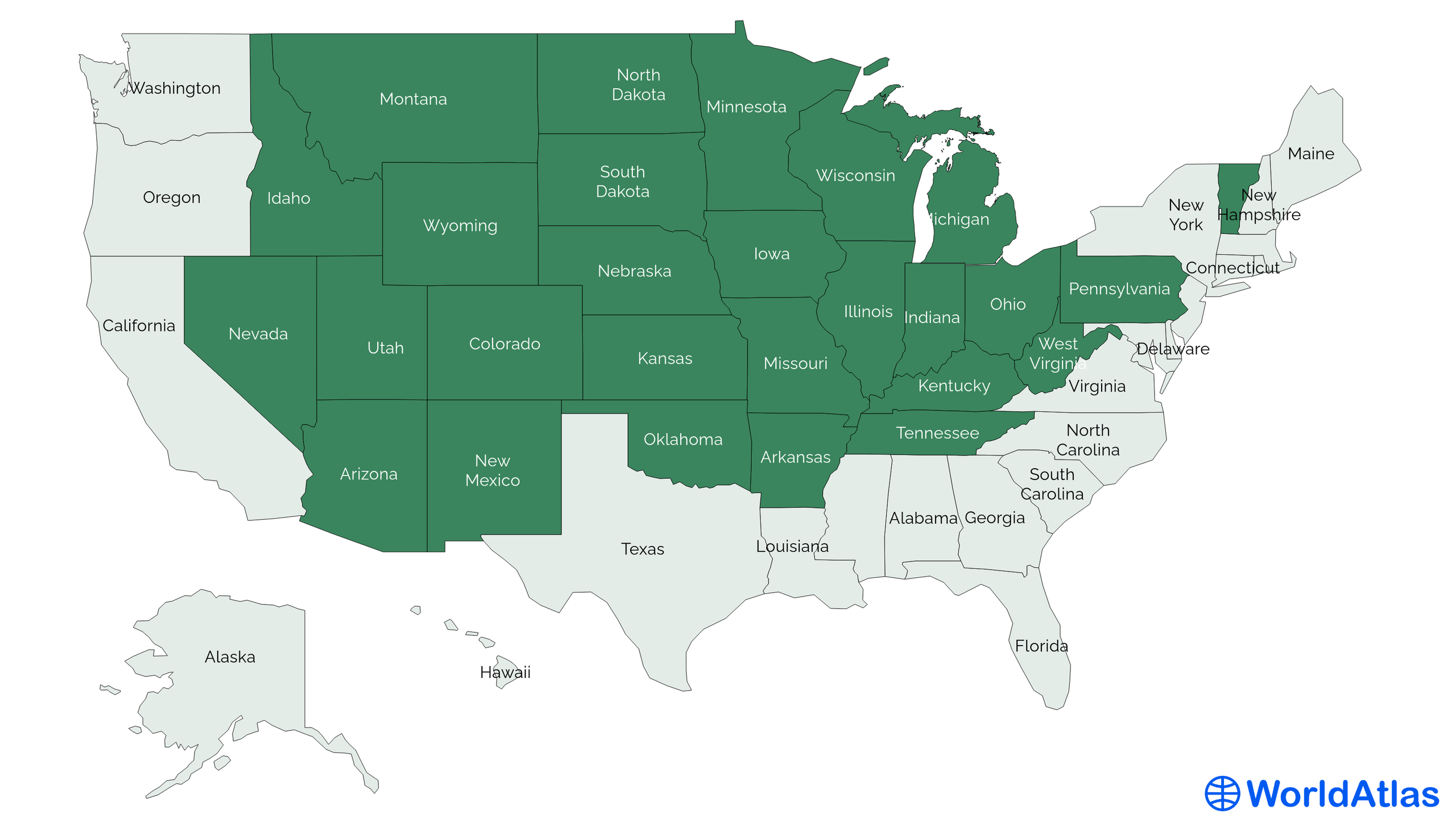
A landlocked state is one whose borders do not touch an ocean, gulf, or open sea. The United States has 27 of them, all of which sit on the contiguous mainland of North America. They split into three tiers depending on how many states or provinces a resident has to cross to reach an ocean: 16 are singly landlocked, 10 are doubly landlocked, and one, Nebraska, is triply landlocked. The District of Columbia is also enclosed by other states, but it is a federal district, not a state, and is not counted in the 27.
What "Landlocked" Really Means
Landlocked is a stricter category than it sounds. A state is landlocked if its borders do not touch an ocean coast, even if it borders a major inland body like the Great Lakes. By that definition, Michigan, Ohio, Minnesota, and Wisconsin all count as landlocked despite having long Great Lakes shorelines. Pennsylvania has a 51-mile stretch of Lake Erie shore but no Atlantic frontage, so it is also on the list. The Mississippi River, which historically carried interior states' goods to the Gulf, does not change the count either, even though it functions as an oceanic on-ramp for shipping.
The United States is unusual in this respect. Most countries with the territory and population of a typical US state would be sovereign nations, and a sovereign country in the same position would be classified as landlocked under international law, with all the trade, treaty, and shipping consequences that brings. The 27 landlocked US states are insulated from those problems by being part of a federal system that guarantees them free movement to the coast, but the geographic reality still shapes how they developed.
The 16 Singly Landlocked States

A singly landlocked state can reach an ocean by crossing one other state, province, or country. Sixteen states qualify, and they fall into a few clear regional clusters.
The interior Southeast. Arkansas, Kentucky, Tennessee, and West Virginia all sit one state away from the Atlantic or the Gulf of Mexico. Arkansas reaches the Gulf through Louisiana, Mississippi, or Texas. Kentucky reaches the Atlantic through Virginia (Tennessee actually lies to its south, not its north). Tennessee, which borders eight other states (more than any state except Missouri), can pick from Georgia, North Carolina, or Virginia for the Atlantic and Mississippi or Alabama for the Gulf. West Virginia reaches the Atlantic through Virginia or Maryland.
The Mountain West and Southwest. Arizona, Idaho, Montana, Nevada, and New Mexico are each one state from a saltwater coast. Arizona reaches the Pacific through California or the Gulf of California through Sonora, Mexico. Idaho borders Oregon, Washington, and British Columbia, all of which open onto the Pacific. Montana reaches the Pacific only through British Columbia. Nevada reaches the Pacific through California or Oregon. New Mexico reaches the Gulf of Mexico through Texas or the Gulf of California through Sonora.
The northern Plains and Midwest. Minnesota, North Dakota, Michigan, and Ohio are all one province from a Canadian saltwater body. Minnesota reaches Hudson Bay through Manitoba, North Dakota does the same, and both can also reach James Bay through Ontario. Michigan, despite touching four of the five Great Lakes (Superior, Michigan, Huron, and Erie), reaches an actual ocean only by crossing Ontario to James Bay. Ohio sits in the same position one state south.
Oklahoma and Pennsylvania. Oklahoma reaches the Gulf of Mexico through Texas. Pennsylvania, despite its small Lake Erie shore, reaches the Atlantic through New Jersey, New York, Delaware, or Maryland.
Vermont. Vermont is the only New England landlocked state. It reaches the Atlantic through New Hampshire and Maine, through Massachusetts, or through New York, and reaches James Bay through Quebec.
The 10 Doubly Landlocked States

A doubly landlocked state needs to cross two other states (or provinces) to reach saltwater. Ten states fall in this category, and between them they have routes to all three oceans bordering North America.
The interior Mountain West. Colorado, Utah, and Wyoming sit two states deep from any coast. Colorado reaches the Gulf through New Mexico-Texas or Oklahoma-Texas, and the Pacific through Arizona-California. Utah reaches the Pacific through Nevada-California or Arizona-California, and the Gulf of California through Arizona-Sonora. Wyoming reaches the Pacific through Idaho-Oregon or Idaho-Washington, or via Montana-British Columbia.
The Great Plains and Midwest. Kansas reaches the Gulf through Oklahoma-Texas. Missouri can take Oklahoma-Texas, Arkansas-Louisiana, or Tennessee-Mississippi to the Gulf, or Kentucky-Virginia to the Atlantic. Iowa reaches Hudson Bay through Minnesota-Manitoba and James Bay through Minnesota-Ontario. South Dakota reaches the same two bays through North Dakota-Manitoba and Minnesota-Ontario respectively.
The eastern Midwest. Illinois and Indiana both reach the Atlantic through Kentucky-Virginia, and Hudson Bay through Michigan-Ontario. Wisconsin reaches Hudson Bay through Minnesota-Manitoba or Michigan-Ontario, with James Bay accessible through the same two routes.
The One Triply Landlocked State

Nebraska is the only US state that requires crossing at least three other states or provinces to reach any ocean, gulf, or major bay. The Atlantic is reachable through Missouri, Tennessee, and then North Carolina, Virginia, or Georgia. The Gulf of Mexico is reachable through Kansas, Oklahoma, and Texas. The Pacific is reachable through Wyoming, Idaho, and then Oregon, Washington, or British Columbia. Hudson Bay is reachable through South Dakota, North Dakota, and Manitoba. Every direction is at least a three-step path, which is what makes Nebraska a geographic outlier even among the rest of the landlocked group.
Why Landlocked Status Actually Matters
For most of the US, being landlocked is a quiet fact. The federal system means there are no border tariffs, no transit treaties, and no foreign-state veto over a state's exports. But the geography still shaped the way the country grew.
Through the 19th century, the most important "coast" for many landlocked US states was not saltwater at all but the Mississippi River system. Cities like St. Louis, Memphis, Cincinnati, and Pittsburgh were in effect ocean ports, because riverboats moved cotton, grain, coal, and finished goods down to New Orleans and out to the Gulf. The interior states that prospered earliest were the ones with good river access. Landlocked states without that access, like the high plains and the mountain West, developed later and more slowly, and their economies leaned harder on rail.
The opening of the St. Lawrence Seaway in 1959 changed the math again, turning the Great Lakes into a working ocean port system. Cargo loaded in Duluth, Minnesota, or Cleveland, Ohio, could now reach the Atlantic without ever changing ships. Several states on this article's list, including Michigan, Minnesota, Wisconsin, and Ohio, are landlocked in the strict sense but have direct ocean shipping access today as a practical matter.
Landlocked status also still shapes a few specific things. States without saltwater ports do not host naval bases or major commercial fishing fleets. They do not collect port-of-entry customs revenue. And they have no coastal hurricane exposure, which is one reason insurance rates and federal disaster spending look so different in a state like Nebraska compared to a state like Florida.
Twenty-Seven States, Three Tiers, One Geography
The 27 landlocked US states are not a uniform group. Some sit a single border crossing from saltwater, some are buried two states deep, and one sits three states deep in every direction. The category is also not the same as "isolated": several of the most economically connected states in the country, including Illinois, Pennsylvania, and Michigan, are technically landlocked but plug into the global shipping system through inland waterways. The geography stays the same. The way each state has dealt with it is what tells the actual story.