Maps of Arkansas

Arkansas, bordered by Missouri to the north, Tennessee and Mississippi to the east, Louisiana to the south, Texas to the southwest, and Oklahoma to the west, encompasses a total area of approximately 53,179 mi2 (137,732 km2).
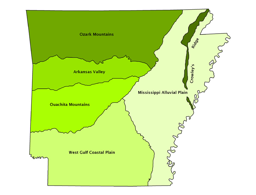
Arkansas is divisible into six primary geographic regions:
Ozark Mountains cover the northern part of Arkansas and are characterized by rugged terrain with plateaus, deep valleys, and clear streams. The region is part of the U.S. Interior Highlands, the only major mountainous region between the Rocky Mountains and the Appalachian Mountains. The highest point in Arkansas, Magazine Mountain at 2,753 feet (839 meters), is located in this region, providing a prominent elevation that influences local climate and weather patterns.
Arkansas Valley lies to the south of the Ozark Plateau and features a wide, flat expanse that follows the course of the Arkansas River. This valley is an important agricultural area due to its fertile soil. The river itself plays a crucial role in the geography of the state, facilitating trade and providing water for irrigation.
Ouachita Mountains stretch to the west of the Arkansas Valley and are known for their distinct east-west orientation, unlike the typical north-south orientation of most mountain ranges in the United States. The Ouachita Mountains region is recognized for its thermal springs, notably within the city of Hot Springs, which is built around the natural hot springs that have been a draw for centuries.
West Gulf Coastal Plain extends across the southern part of Arkansas and into Texas and Louisiana. This region is characterized by its flatlands that slope gently towards the Gulf of Mexico. It encompasses a variety of habitats, including pine forests and marshlands, and is integral to the state's agriculture due to its rich soil.
Mississippi Alluvial Plain, also known as the Delta, borders the Mississippi River on the eastern side of Arkansas. This region is a broad, flat, fertile area formed by the historical flooding of the Mississippi and its tributaries, leading to a landscape dominated by bayous, marshes, and oxbow lakes.
Crowley's Ridge rises dramatically from the Mississippi Alluvial Plain as a unique geological formation. This narrow, linear ridge extends from northeastern to southeastern Arkansas and is noted for its rich, fertile soil, distinct from the surrounding Delta region due to its loess deposits.
Major Bodies of Water: Major rivers include the Arkansas, Mississippi, Red, Ouachita, and White rivers. These waterways are vital for transportation, irrigation, and as sources of water. Additionally, the state has many man-made lakes, such as Lake Ouachita, Bull Shoals Lake, and Greers Ferry Lake, which are important for recreation, wildlife habitat, and water storage.
Counties Map

The State of Arkansas is divided into 75 counties. In alphabetical order, these counties are: Arkansas County, Ashley, Baxter, Benton, Boone, Bradley, Calhoun, Carroll, Chicot, Clark, Clay, Cleburne, Cleveland, Columbia, Conway, Craighead, Crawford, Crittenden, Cross, Dallas, Desha, Drew, Faulkner, Franklin, Fulton, Garland, Grant, Greene, Hempstead, Hot Spring, Howard, Independence, Izard, Jackson, Jefferson, Johnson, Lafayette, Lawrence, Lee, Lincoln, Little River, Logan, Lonoke, Madison, Marion, Miller, Mississippi, Monroe, Montgomery, Nevada, Newton, Ouachita, Perry, Phillips, Pike, Poinsett, Polk, Pope, Prairie, Pulaski, Randolph, Saint Francis, Saline, Scott, Searcy, Sebastian, Sevier, Sharp, Stone, Union, Van Buren, Washington, White, Woodruff, and Yell.
With an area of 137,732 sq. km, the State of Arkansas is the 29th largest and the 33rd most populous state in the USA. Located in Pulaski County, in the central part of the state is Little Rock – the capital, the largest and the most populous city of Arkansas. Little Rock also serves as the administrative, cultural, economic, and transportation center of Arkansas.
Where is Arkansas?

The State of Arkansas is located in the south-central region of the United States. It is bordered by the state of Missouri in the north; by Tennessee and Mississippi in the east, by Louisiana in the south, by Texas in the southwest and by Oklahoma in the west.
Regional Maps: Map of North America
Outline Map of Arkansas

The above blank map represents the State of Arkansas, located in the south-central region of the United States. The above map can be downloaded, printed and used for geography education purposes like map-pointing and coloring activities.

The above outline map represents the State of Arkansas, located in the south-central region of the United States.
Key Facts
| Legal Name | State of Arkansas |
|---|---|
| ISO 3166 Code | US-AR |
| Capital City | Little Rock |
| Major Cities |
|
This page was last updated on February 5, 2024


