10 US States With The Longest Shorelines
Shoreline mileage measures the places where land meets water, and the total climbs with every bend, bay, inlet, and island edge. The National Oceanic and Atmospheric Administration (NOAA) shoreline-mileage dataset tracks ocean shorelines and tide-influenced bays, sounds, estuaries, and tidal rivers up to the head of tidewater, and includes Great Lakes shores for Great Lakes states.
At the top of the US ranking, Alaska leads the nation with 33,904 miles of shoreline, followed by Florida (8,436 mi) and Louisiana (7,721 mi).
10 US States With The Longest Shorelines
| Rank | State | Shoreline (miles) |
|---|---|---|
| 1 | Alaska | 33,904 |
| 2 | Florida | 8,436 |
| 3 | Louisiana | 7,721 |
| 4 | Maine | 3,478 |
| 5 | California | 3,427 |
| 6 | North Carolina | 3,375 |
| 7 | Texas | 3,359 |
| 8 | Virginia | 3,315 |
| 9 | Michigan | 3,224 |
| 10 | Maryland | 3,190 |
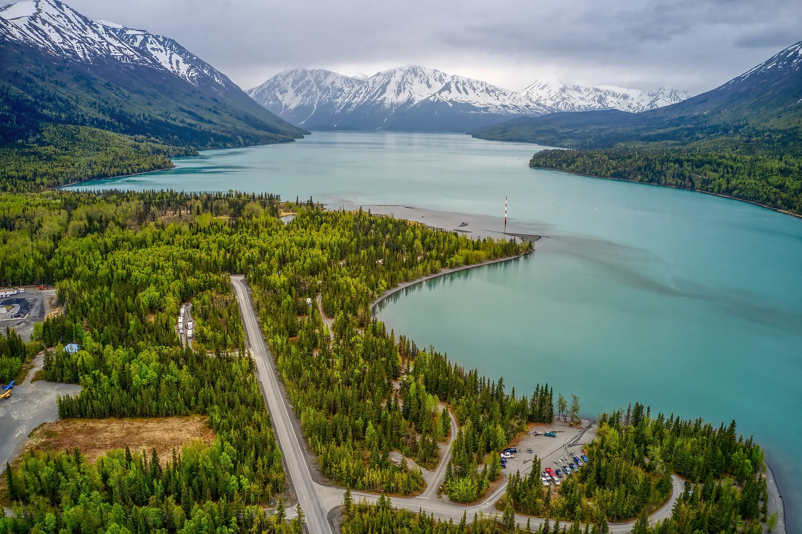
1. Alaska - 33,904 mi

It's certainly no surprise to anyone that Alaska is the state with the most miles of shoreline in the United States. In fact, when compared to the state that follows it on this list, it's not even close.
Overall, Alaska has 33,904 miles of shoreline in NOAA’s accounting, thanks to its vast ocean-facing coasts, countless bays and fjords, and the shorelines of its many islands. That’s roughly four times the shoreline mileage of Florida, the runner-up.
Alaska would surely rank high on this list even without its islands, though, as it's the largest state by area in the nation. Looking at a map of Alaska, the length of its shoreline is not at all surprising when you consider not only its size, but the fact that its coastline zig-zags on all sides. Alaska also has coastline along two different oceans - the Arctic Ocean and the Pacific Ocean - and is the only state for which that's true.
2. Florida - 8,436 mi

The state with the second-most shoreline is Florida, with 8,436 miles of shoreline in NOAA’s accounting. This southern state has miles of waterfront along the Atlantic Ocean and the Gulf of Mexico, plus extensive tide-influenced shorelines around bays, lagoons, and coastal waterways.
Island chains like the Florida Keys and long stretches of barrier islands - including along the Panhandle and down both coasts - add shoreline on multiple sides. With so much water wrapping around peninsulas, islands, and inlets, chances are that most places in Florida are only a short drive from some kind of shoreline.
3. Louisiana - 7,721 mi

Because Louisiana is not known for its beaches, some people may be surprised to find The Pelican State in third place on this list. However, upon deeper inspection, this placement makes complete sense. Louisiana not only borders the Gulf of Mexico, but much of its southern coastline is a maze of wetlands, bayous, estuaries, barrier islands, and tidal waterways - all of which add up quickly under NOAA’s shoreline definition. It’s easy to see how Louisiana can claim 7,721 miles of shoreline when you picture how many edges exist where land and tide-influenced water meet.
4. Maine - 3,478 mi

Maine is another state that might be surprising this high on this list, but it has its fair share of shoreline - and then some. Maine’s general Atlantic coastline is often cited at about 228 miles, but when all of the inlets, bays, coves, and islands along that coast are added in, the shoreline mileage increases dramatically. That intricate, jagged coastal geography is exactly why Maine ranks so high in NOAA’s shoreline totals.
5. California - 3,427 mi

Looking at a map, it's clear that California has a vast amount of shoreline. It's 840 miles from top to bottom, but when you factor in the state’s many bays, inlets, and islands, the total shoreline mileage climbs well beyond the simple north-to-south distance. Features like major bays and the offshore Channel Islands help explain why California’s NOAA shoreline total reaches 3,427 miles.
6. North Carolina - 3,375 mi

Some might be surprised to find North Carolina in sixth place on this list, but it's another state whose map will help visually clarify this ranking. North Carolina's Atlantic Coast is jagged and full of inlets and bays along its entire length. The northern half, particularly around the Albemarle and Pamlico Sounds, features extensive tide-influenced shorelines. Furthermore, the narrow Cape Hatteras and Cape Lookout National Seashore chains of islands, also known as The Outer Banks, have shoreline on both sides of each island, adding immense mileage to North Carolina's shoreline total.
7. Texas - 3,359 mi

If guessing the order of this list, some might imagine that Texas would be higher than the seventh spot, as most people know it's the second-largest state in the country. However, only a portion of the state is coastal. From Port Arthur to Brownsville on the southeastern side of the state, Texas faces the Gulf of Mexico, and its shoreline total is boosted by bays, tidal inlets, and coastal islands along the way.
8. Virginia - 3,315 mi

Virginia has a long coastline along the Atlantic Ocean, so it makes sense that it ranks high on this list. When one looks at a map of the Old Dominion State, this relatively high ranking makes even more sense. Not only does the southern portion of the vast Chesapeake Bay border this state, but rivers like the Potomac, the Rappahannock, the York, and the James all feature large tidal areas full of small inlets, which are included in the total as well. Finally, Virginia also gains even more shoreline because the state includes the Eastern Shore on the Delmarva Peninsula (including Accomack and Northampton counties), which adds more bayside and oceanside edges.
9. Michigan - 3,224 mi

Michigan is the first and only state in the top ten on this list that is not located on the Pacific or Atlantic Ocean. Michigan's vast shoreline exists due to the fact that this state is bordered on almost all sides by the Great Lakes. In fact, Michigan touches four of the five Great Lakes! Lake Michigan is to the west, Lake Superior is to the north, Lake Huron is to the northeast, and Lake Erie is to the southeast. This state is made of two peninsulas surrounded by water, so the fact that it has a whole lot of shoreline makes sense.
10. Maryland - 3,190 mi

Maryland is a relatively small state when compared to most other states in the United States, so it may be surprising to some to see it on this list of lengthy shorelines. However, once one looks at Maryland on a map, the fact that it has 3,190 miles of shoreline makes sense. Not only is much of the coastline in Maryland full of bays and inlets, but the state also borders the gigantic Chesapeake Bay. Maryland only has a short coastline on the Atlantic Ocean, but the Chesapeake Bay and its many tidal rivers and coves create a huge amount of shoreline edge.
These ten states have the most shoreline when it comes to states in the United States, but those that follow these first ten also offer a lot of shoreline as well. Washington state has over 3,000 miles of shoreline. South Carolina, New York, and Georgia each have over 2,000 miles of shoreline. New Jersey, Massachusetts, Oregon, and Hawaii have shorelines totaling over 1,000 miles. From ocean coasts to tidal bays and sounds (and Great Lakes shores in the Midwest), the United States has an incredible variety of shorelines - and they’ve long shaped how people live, travel, work, and play across the country.
US States Ranked by Total Shoreline
| Rank | State | Shoreline (miles) |
|---|---|---|
| 1 | Alaska | 33,904 |
| 2 | Florida | 8,436 |
| 3 | Louisiana | 7,721 |
| 4 | Maine | 3,478 |
| 5 | California | 3,427 |
| 6 | North Carolina | 3,375 |
| 7 | Texas | 3,359 |
| 8 | Virginia | 3,315 |
| 9 | Michigan | 3,224 |
| 10 | Maryland | 3,190 |
| 11 | Washington | 3,026 |
| 12 | South Carolina | 2,876 |
| 13 | New York | 2,625 |
| 14 | Georgia | 2,344 |
| 15 | New Jersey | 1,792 |
| 16 | Massachusetts | 1,519 |
| 17 | Oregon | 1,410 |
| 18 | Hawaii | 1,052 |
| 19 | Wisconsin | 820 |
| 20 | Connecticut | 618 |
| 21 | Alabama | 607 |
| 22 | Rhode Island | 384 |
| 23 | Delaware | 381 |
| 24 | Mississippi | 359 |
| 25 | Ohio | 312 |
| 26 | Minnesota | 189 |
| 27 | Pennsylvania | 140 |
| 28 | New Hampshire | 131 |
| 29 | Illinois | 63 |
| 30 | Indiana | 45 |
Shoreline miles per NOAA’s shoreline definition (tidal shoreline + Great Lakes). Landlocked states are not shown.


