Gulf Of California
Gulfs may be defined as a portion of the sea or an ocean that extends into the landmass. They greatly vary in size, shape, and depth and are formed by the movements of tectonic plates. Also referred to as the Sea of Cortés, the Gulf of California is a long and narrow extension of the Eastern Pacific Ocean and is geographically positioned along the northwestern coast of Mexico. The Gulf of California separates the mountainous Lower California Peninsula/Baja California Peninsula in the west from the states of Sonora and Sinaloa on the mainland of Mexico in the east.

Geography
The Gulf of California covers an area of 160,000 sq. km and has a long coastline of approximately 4,000km. The Gulf is surrounded by the Mexican states of Sonora, Sinaloa, Baja California, and Baja California Sur. The Gulf of California is about 1,126km long and has a maximum width ranging between 48 to 241km. The Gulf is divided into two portions and is separated by a narrowing that is marked by the islands of Tiburón and Angel de la Guarda. The northern portion is relatively shallow, with a mean depth of 180m, while the southern portion contains many depressions and the deepest of these depressions reaches a maximum depth of over 3,000m. The perilous Salsipuedes Basin has been created by the action of a powerful tidal bore that rushes between the two portions of the Gulf.

The head of the gulf is dominated by the large Colorado River Delta through which the Colorado River drains into the Gulf. The gulf’s eastern shores are surrounded by highlands that are broken by several major Mexican rivers that drain into the Gulf of California including the Rio Sonora River, the Sinaloa River, the Mayo River, the Fuerte River, and the Yaqui River. The long coastline of the gulf is extremely irregular and forms numerous small bays. There are also many ‘negative estuaries’, and three types of shores including the sandy beach, the rocky shore, and the tidal flat in the Gulf of California. La Paz on the Baja California Peninsula and Guaymas on the Mexican mainland are the two major ports that are located along the shores of the Gulf.
Geology

Geological studies have determined that the Gulf of California was created around 5.3 million years ago due to the movement of tectonic plates that separated the Baja California Peninsula from the North American Plate. The East Pacific Rise that runs south from the Gulf of California separates the Pacific Plate from the North American Plate, the Nazca Plate, the Rivera Plate, the Cocos Plate, and the Antarctic Plate. The East Pacific Rise extends up to the center of the Gulf along the seabed. This northernmost extension of the East Pacific Rise is referred to as the Gulf of California Rift Zone, which extends for more than 1,300km from the mouth of the Gulf of California to the southern end of the San Andreas Fault. Movements along the San Andreas Fault are caused by the spreading beneath the East Pacific Rise. The northward movement along the fault about 3 to 4 million years ago, resulted in the creation of the Baja Peninsula and the subsequent detachment of the Baja California Peninsula from the Mexican mainland. The Gulf of California then began to open as a series of offsets along with the San Andreas fault system. The tectonic activities along the faults continue till date that is leading to the spreading apart of the plates and the growing of the California gulf between the peninsula and the Mexican mainland.
Islands

There are about 37 major islands in the Gulf of California that is mostly located on its western side. It is believed that these islands were created due to volcanic eruptions and several of these islands are home to volcanoes. Some of the major islands include the Isla Ángel de la Guarda, Isla Tiburón, Islas Marías, Isla Partida, Islas San Francisco, Isla Coronados, etc.
It is estimated that there are more than 900 islets and islands in the Gulf of California that cover a total area of about 420 hectares. In 1978, all these islets and islands were designated as “Area Reserve and Migratory Bird Refuge and Wildlife”. In June 2000, all the islands were declared “flora and fauna protection area”. All the islands in the gulf eventually became a part of the MAB program under UNESCO. In 2005, the Islands and the Protected Areas of the Gulf of California were designated as a UNESCO World Heritage Site.
Climate
Due to the presence of an uninterrupted chain of mountains on the Baja California Peninsula, the Gulf of California experiences a ‘continental’ climate rather than an ‘oceanic’ climate. The temperature of the surface water ranges from 24°C during summers to about 16°C during winters. However, the temperatures vary greatly and the water is comparatively much warmer on the coasts than in the open ocean. The northern part of the gulf often experiences cold winters where the water temperatures drop below 8°C. The mean annual range of the surface water salinity vary between 3.5 and 3.58 with the salinity of the northern gulf waters being comparatively higher than the central and southern parts of the gulf.
Ecology

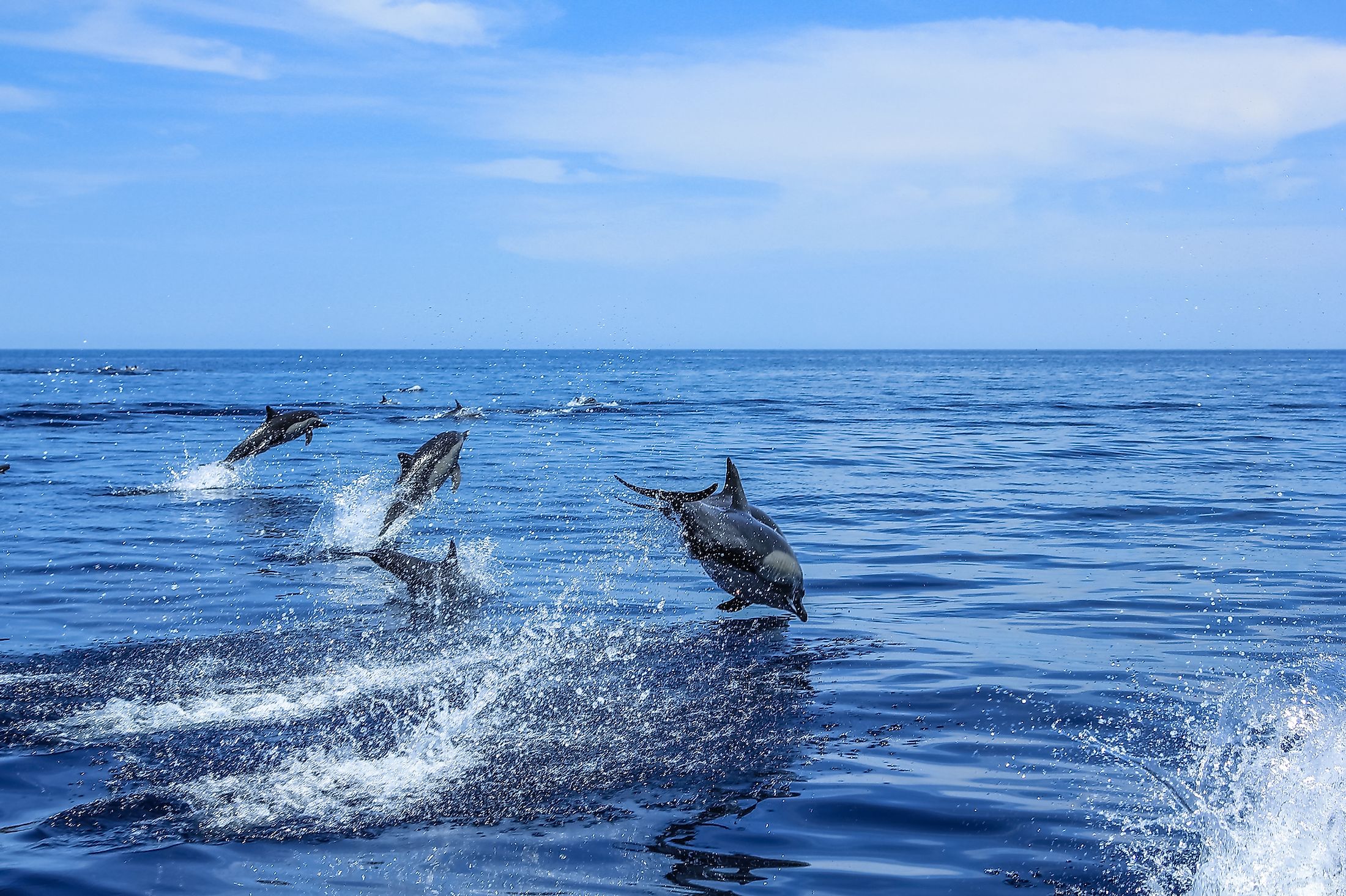
The Gulf of California is considered one of the most diverse seas on the planet. The waters of the Gulf are home to more than 5,000 species of micro-invertebrates. The Gulf of California also supports a high diversity of marine life including more than 900 species of fish along with coral reefs, dolphins, and marine turtles. The gulf supports many endemic marine animals such as the vaquita. Several migratory species like the California gray whale, humpback whale, manta ray, killer whale, Humboldt squid, the blue whale, and the leatherback sea turtle. Resident populations of sperm whales and fin whales are also found in the gulf waters. The marine waters also support some of Mexico’s most important fisheries and the entire region serves as a significant place for the commercial fishing industry. The islands of the gulf provide critical breeding habitats for many seabirds.
Brief History
In 1532, the Spanish conquistador Hernán Cortés reached the gulf while exploring the Pacific coast of Mexico. Cortés and his team however returned to Spain with a handful of pearls that they had collected from the gulf. In 1535, Cortés led a second expedition across the gulf to the Baja Peninsula, which was then thought to be an island. In 1539, the Spanish explorer – Francisco de Ulloa, who was exploring the west coast of Mexico, confirmed that Baja California was a peninsula and not an island. He initially named the gulf “Mar Bermejo” or “Vermilion Sea” referring to the red color of the plankton blooms. The Gulf was also named as the “Sea of Cortés” by Francisco de Ulloa in the honor of the Spanish conquistador Hernán Cortés. The US ceded the Gulf of California, the Baja Peninsula, and a thin strip of land that connected the peninsula with the Mexican mainland to Mexico via the Treaty of Guadalupe.


