The Largest Countries In The World
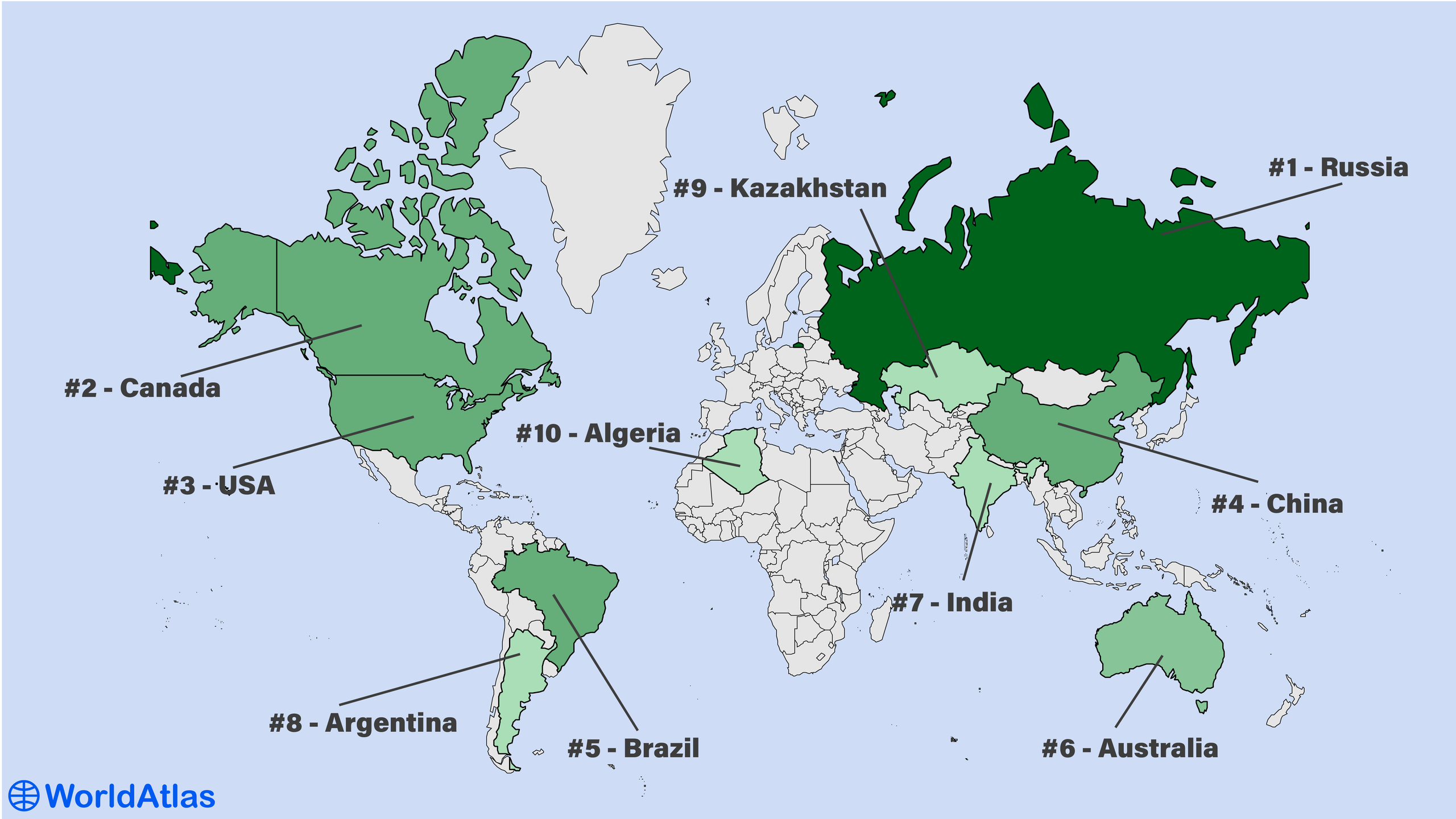
The largest countries in the world are Russia, China, Canada, and the United States, with an area of 17 million km2, 9.98 million km2, 9.7 million km2, and 9.3 million km2, respectively.
Russia, the largest country in the world, covers approximately 11% of the world’s land surface. Russia has nearly twice the area of China, Canada, or the United States, which are the second, third, and fourth-largest countries in the world.
Below, we explore the 10 largest countries of the world and their geographies.
The Largest Countries By Total Area
| # | Country | Total Area km2 | Total Area mi2 |
|---|---|---|---|
| 1 | Russia | 17,098,242 | 6,601,665 |
| 2 | Canada | 9,984,670 | 3,855,101 |
| 3 | China | 9,706,961 | 3,747,877 |
| 4 | United States | 9,372,610 | 3,618,783 |
| 5 | Brazil | 8,515,767 | 3,287,955 |
| 6 | Australia | 7,692,024 | 2,969,906 |
| 7 | India | 3,287,590 | 1,269,345 |
| 8 | Argentina | 2,780,400 | 1,073,518 |
| 9 | Kazakhstan | 2,724,900 | 1,052,089 |
| 10 | Algeria | 2,381,741 | 919,595 |
Jump to the table of the countries in the world ranked by Total Area.
1. Russia - 17,098,242 km2

- Population: 146 million
- Time zones: UTC +2:00 to +12:00
Russia is the planet’s undisputed giant, spreading across 17 million km², roughly one-ninth of Earth’s inhabited land, and bridging Europe and Asia. From the Baltic exclave of Kaliningrad to the Bering Strait’s Big Diomede Island, its territory stretches 9,000 km west-east and 4,500 km north-south, intersecting eleven time zones. The country commands the world’s fourth-longest coastline (37,653 km), touching the Arctic and Pacific.
Topographically, Russia is a study in contrasts: low plains dominate the European sector and the vast West Siberian Plain, while the Urals mark a modest but historic continental divide. Eastward rise the volcanic ridges of Kamchatka and the rugged mountains of the Caucasus, where Mount Elbrus stands as Europe’s highest peak at 5,642 m. An unparalleled river network, the Volga, Ob-Irtysh, Yenisei, and Lena, among others, drains into three oceans, and Lake Baikal holds one-fifth of the world’s unfrozen fresh water. Climate zones range from Arctic tundra and world-spanning taiga forests to fertile steppe and humid subtropics on the Black Sea. Rich in minerals and timber, yet sparsely populated outside its cities, Russia’s sheer scale shapes its geopolitical reach and environmental stewardship alike. The taiga alone stores more carbon than any other national ecosystem on Earth.
2. Canada - 9,984,670 km2
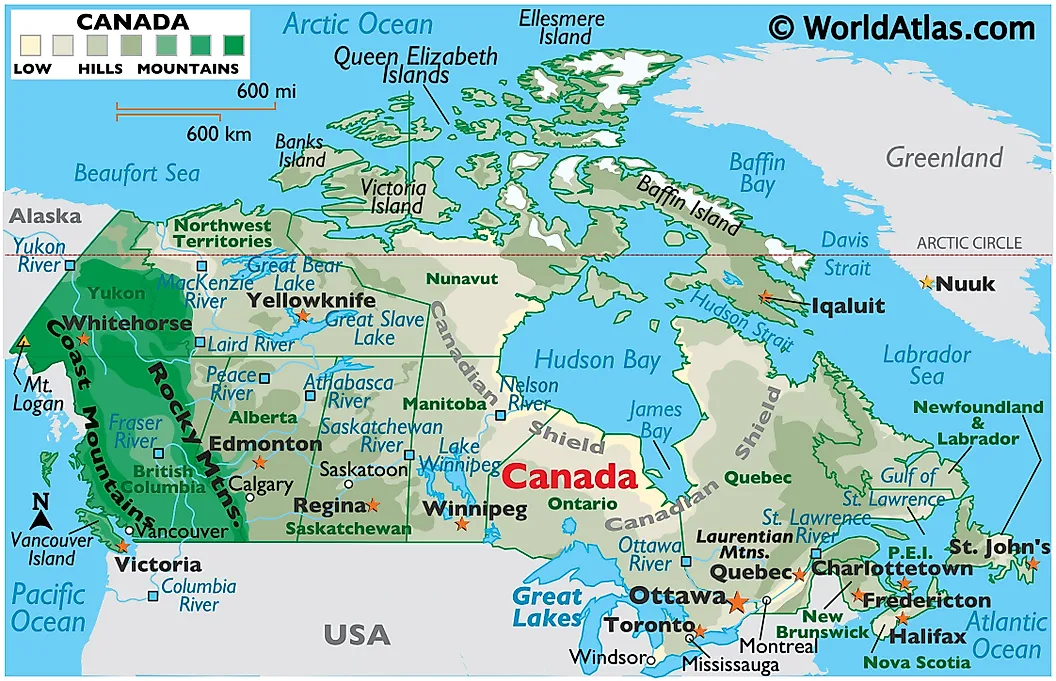
- Population: 40 million
- Time Zones: UTC −8:00 to UTC −03:30
Canada ranks as the world’s second-largest country, sprawling across 9.98 million km² from the Atlantic in the east to the Pacific in the west and the Arctic Ocean in the north. Its 243,042 kilometer shoreline, the longest on Earth, wraps an enormous patchwork of fjorded coasts, island archipelagos, and three oceanic fronts.
Seven broad physiographic regions shape the landscape: the ancient, mineral-rich Canadian Shield; the fertile Great Lakes-St. Lawrence Lowlands; the sweeping Interior Plains and Prairie grasslands; the rugged Western Cordillera dominated by the Rockies and Coast Mountains; the wetland-laden Hudson Bay Lowlands; the glacier-sculpted Appalachian uplands; and the ice-bound Arctic Archipelago, home to Ellesmere and Baffin, two of the planet’s ten largest islands. Mount Logan in Yukon rises to 5,959 m, while the Mackenzie River winds 4,241 km toward the Beaufort Sea.
Canada possesses more lakes than any other nation and holds nearly a fifth of the world’s surface fresh water; its forests blanket 42 percent of the land, forming a vast boreal carbon reserve. Climate diversity is equally striking: temperate rainforests fringe British Columbia, continental prairie summers can top 40 °C, and Nunavut communities endure polar night and permafrost. Across this immense northern realm, untapped resources and ecological stewardship remain entwined national priorities for the twenty-first century and beyond.
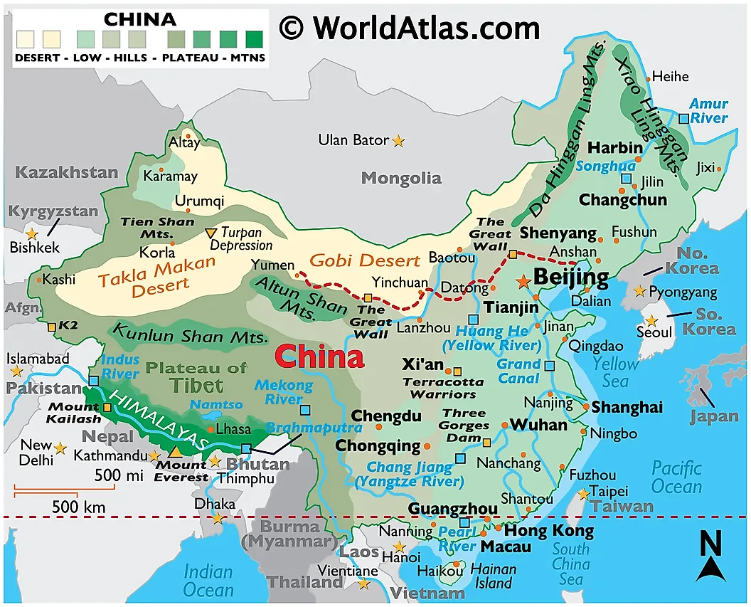
3. China 9,706,961 km2
- Population: 1.4 billion
- Time Zones: UTC +8:00
China is the world’s third- or fourth-largest nation, spanning 9.7 million km², slightly bigger than the United States. Its 14,500-km coastline faces the Bohai, Yellow, East China, and South China seas, while 22,000 km of land frontiers touch 14 neighbours, more than any other country.
A dramatic west-to-east staircase shapes the land: the Tibetan Plateau, averaging 4 km in elevation and crowned by Mount Everest (8,848 m), descends through the Kunlun, Tien Shan, and Himalaya into the sunken Taklamakan and Gobi deserts, then tilts toward the fertile North China and Yangtze plains. The Yangtze (6,300 km) and Yellow (5,464 km) rivers, with the Pearl network, underpin intensive farming that feeds the planet’s largest population and powers huge hydropower schemes such as Three Gorges.
Climate zones range from tropical monsoon on Hainan to sub-arctic winters in Heilongjiang; typhoons, dust storms and seasonal floods mark this breadth. Roughly a fifth of the country is desert, yet 15 percent remains arable, sustained by terracing and vast irrigation. Coal, hydrocarbons and rare-earth metals, plus the world’s greatest hydropower potential, add economic muscle to landscapes that range from Yunnan’s karst towers to the rice terraces of Guangxi and Sichuan’s misty red canyons.
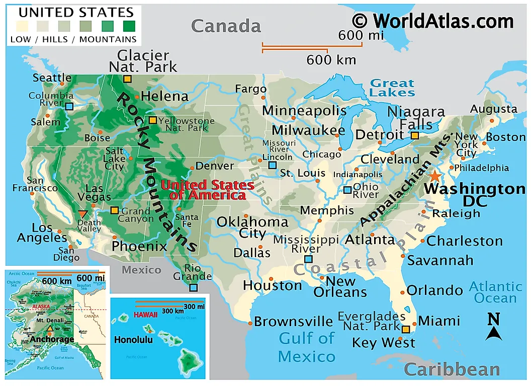
4. United States - 9,372,610 km2
- Population: 340 million
- Time Zones: UTC −10:00 to UTC −5:00
The United States spans 9.8 million km² across North America and the Pacific, ranking third-or-fourth globally by area. Forty-eight contiguous states stretch from the Atlantic to the Pacific, while Alaska projects into the Arctic and Hawaii forms a volcanic archipelago in tropical Oceania. More than 12,000 km of coastline face three oceans, and shared borders with Canada and Mexico trace the planet’s longest binational frontier and a continental south rim.
Topographically, the nation steps upward from the Atlantic-Gulf coastal plain through the forested Appalachians and Mississippi basin to the rolling Great Plains, then surges skyward into the Rocky Mountains, desert plateaus of the Basin-and-Range, and the Sierra Nevada and Cascades. Denali in Alaska crowns North America at 6,190 m, while Death Valley sinks 86 m below sea level.
Hydrologically, the Missouri-Mississippi system drains the heartland, the Columbia and Colorado carve the West, and the Great Lakes hold one-fifth of the world’s fresh surface water. Climate belts run from Arctic tundra and subarctic boreal forest to prairie continental interiors, subtropical Gulf and Atlantic coasts, Mediterranean California, Sonoran desert, and Hawaiian rainforest; the clash of air masses fuels the planet’s most prolific tornado and hurricane activity.
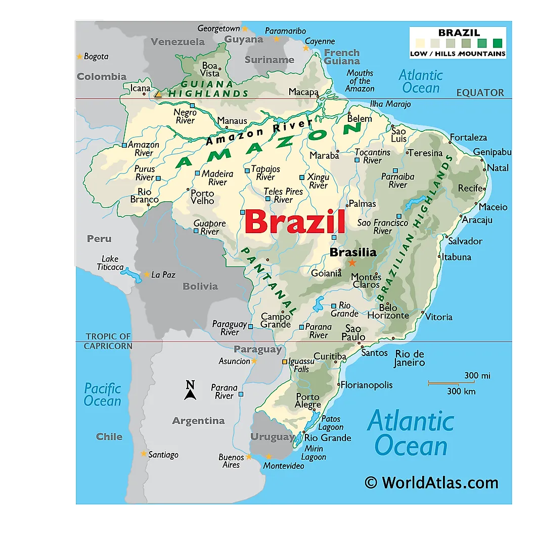
5. Brazil - 8,515,767 km2
- Population: 211 million
- Time Zones: UTC −5:00 to UTC −2:00
Brazil, the world’s fifth-largest country at 8.5 million km², occupies nearly half of South America and touches every continental neighbour except Chile and Ecuador. A 7,490 km Atlantic coastline frames the nation’s diverse interior, where three broad landforms dominate: the vast Amazon Basin in the north, the ancient Brazilian Highlands that arc south-eastward, and a thin coastal plain studded with escarpments and sandy beaches.
The Amazon, draining 45% of Brazilian territory, carries one-fifth of Earth’s running fresh water and nourishes the planet’s largest tropical rainforest—an ecological engine of global climate. South-westward, the Pantanal forms the world’s greatest seasonal wetland, while the Paraná-Paraguai system powers giant hydro-electric plants such as Itaipu.
East of the 60°W meridian, crystalline plateaus rise to nearly 3,000 m at Pico da Neblina and descend abruptly to fertile coastal lowlands. These highlands house cerrado savannas, Atlantic Forest remnants and iron-rich ores that underpin Brazil’s mining prowess.
Straddling the Equator to 34°S, Brazil spans equatorial, tropical and subtropical belts: the North bakes in humid heat, the Northeast endures cyclical drought, and the far South sees frosts among Araucaria pines. Abundant hydropower, timber and mineral reserves make the country a resource giant, yet accelerating deforestation and wetland loss test its stewardship of this continental-scale mosaic.
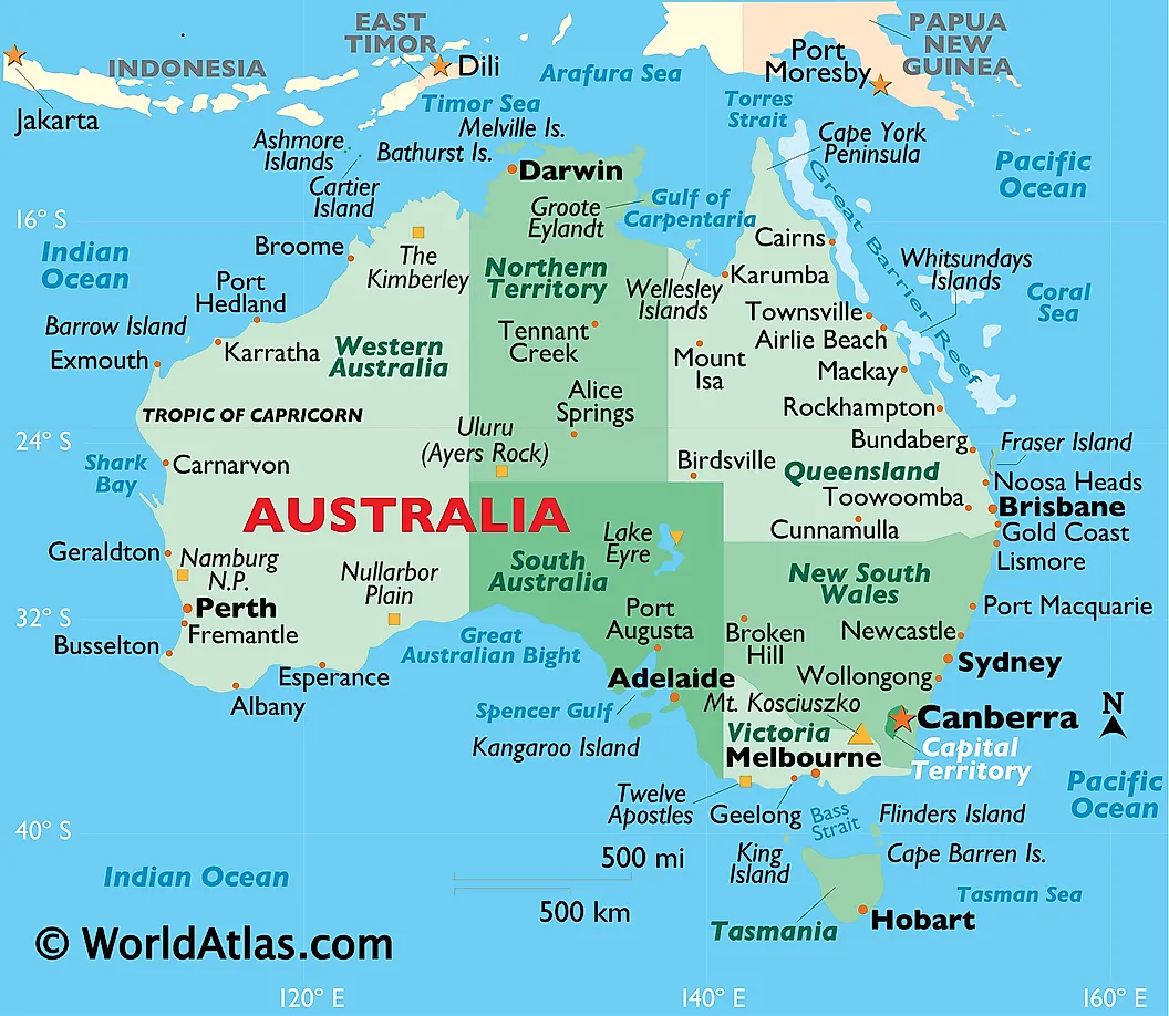
6. Australia - 7,692,024 km2
- Population: 27 million
- Time Zones: UTC +8:00 to +10:00
Australia, the world’s sixth-largest country, spans over 7.6 million km² and occupies the entire Australian continent. Isolated by the Indian and Pacific Oceans, it has no land borders but claims the third-largest Exclusive Economic Zone on Earth. Its geography ranges from vast deserts and semi-arid plains in the Outback to tropical rainforests in the north and temperate woodlands in the southeast. Most of the population lives in coastal cities along the eastern and southeastern seaboards.
The terrain is dominated by three major regions: the low-lying Western Plateau, the Central Lowlands with major basins like the Murray-Darling and Lake Eyre, and the Eastern Highlands, including the Great Dividing Range and Mount Kosciuszko, the country’s highest point at 2,228 m. Australia is the driest inhabited continent, with a highly variable climate, tropical in the north, temperate in the south, and arid across much of the interior.
The Great Barrier Reef, off the northeast coast, is the world’s largest coral reef system. Natural hazards include bushfires, droughts, heatwaves, cyclones, and occasional floods. Rich in minerals and timber, Australia is ecologically unique, with distinct flora and fauna shaped by millennia of geographic isolation and ancient geology, making its landscape both rugged and biodiverse.
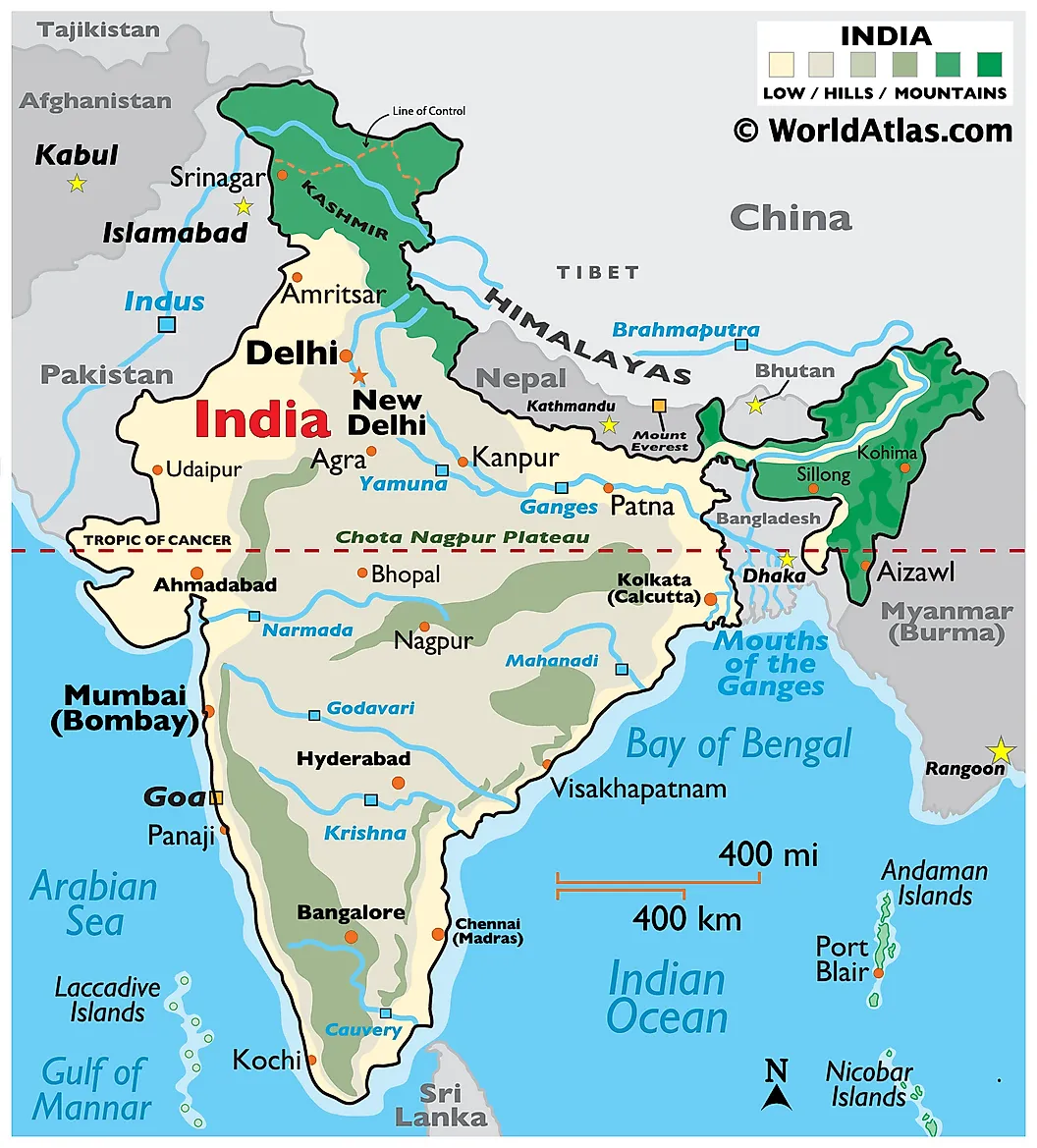
7. India - 3,287,590 km2
- Population: 1.43 billion
- Time Zones: UTC +5:30
India, the seventh-largest country by area (3.29 million km²), occupies a vast portion of South Asia, bordered by the Himalayas in the north and flanked by the Indian Ocean to the south. Its 15,200 km land frontier touches six countries, while its 7,516 km coastline meets the Arabian Sea, Bay of Bengal, and the broader Indian Ocean. The mainland extends 3,214 km north-south and 2,933 km east-west.
India’s landscape is extraordinarily diverse, ranging from the towering Himalayan peaks, home to Kangchenjunga (8,586 m), the world's third-highest mountain, to the arid Thar Desert, fertile Indo-Gangetic Plain, tropical Western Ghats, and the Deccan Plateau. Major rivers like the Ganges, Brahmaputra, and Godavari shape fertile floodplains and support dense populations and agriculture. The Sundarbans Delta in the east is the world's largest tidal halophytic mangrove forest.
India’s climate spans from equatorial in the far south to alpine in the north, heavily influenced by the monsoon. The Andaman and Nicobar and Lakshadweep island groups extend India’s reach deep into the Indian Ocean, enhancing maritime influence. India’s ecological zones include rainforests, deserts, wetlands, and alpine meadows, each supporting high biodiversity and vital resources in a country where geography and demography are deeply intertwined.
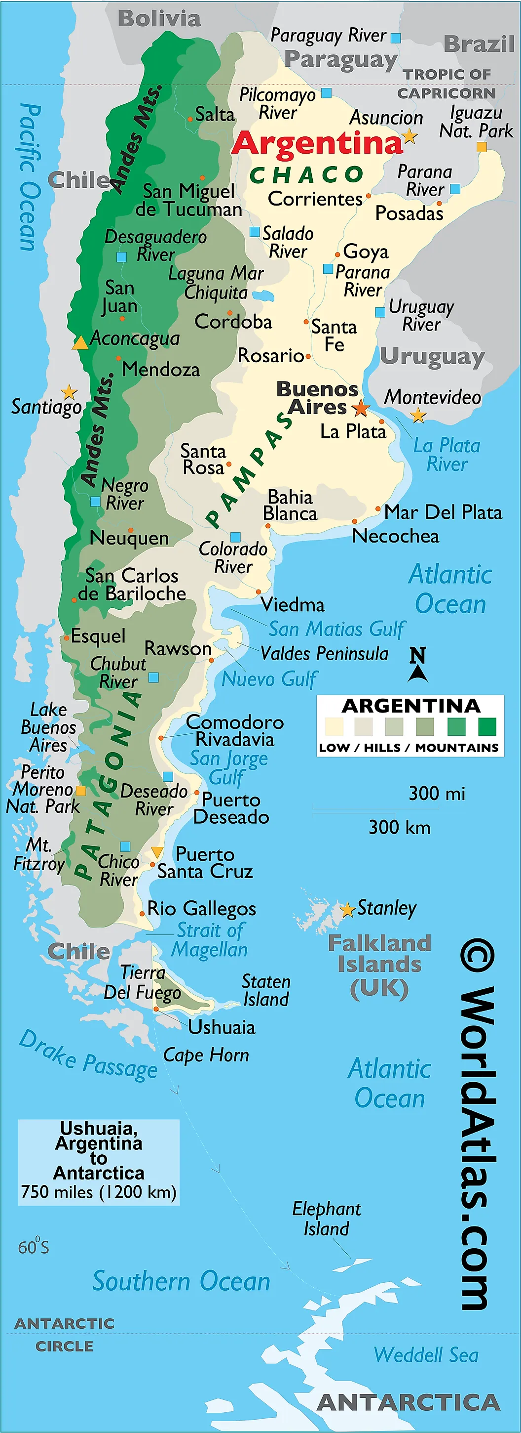
8. Argentina - 2,780,400 km2
- Population: 47 million
- Time Zones: UTC −3:00
Argentina, the eighth-largest country in the world at 2.78 million km², stretches along South America's southern cone from the Tropic of Capricorn to near Antarctica. It borders Chile to the west, Bolivia and Paraguay to the north, Brazil and Uruguay to the northeast, and the South Atlantic Ocean to the east, boasting nearly 5,000 km of coastline. The country encompasses striking geographic contrasts: the towering Andes Mountains, including Aconcagua (6,960 m), the highest peak outside Asia, line the western frontier, while the vast Pampas in the east support intensive agriculture.
To the north lie the wetlands of the Gran Chaco and the subtropical rainforests of Misiones, home to the mighty Iguazú Falls. Central Argentina features temperate plains, and the arid plateau of Patagonia dominates the south, reaching down to Tierra del Fuego and the windswept southern tip of the continent. Argentina also claims a sector of Antarctica and several South Atlantic islands.
Major rivers like the Paraná and Uruguay form the Río de la Plata estuary, a vital waterway for trade and biodiversity. Climate ranges from subtropical in the north to subpolar in the south, with variable rainfall and seasonal extremes, shaping diverse ecosystems, rich farmland, and world-renowned natural landmarks.
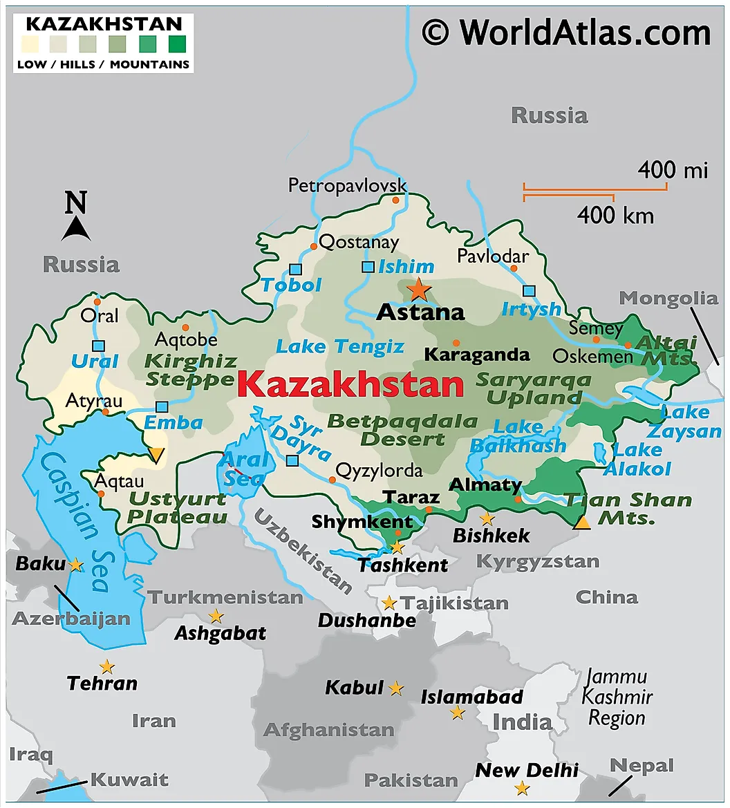
9. Kazakhstan - 2,724,900 km2
- Population: 20 million
- Time Zones: UTC +5:00 to +6:00
Kazakhstan, the world’s ninth-largest country at 2.7 million km², straddles Central Asia and a small part of Eastern Europe. It shares vast land borders with Russia, China, Kyrgyzstan, Uzbekistan, and Turkmenistan, and has a long shoreline along the Caspian Sea. Despite its size, Kazakhstan is landlocked, with most of its territory composed of deserts (44%), semi-deserts (33%), and vast steppes (26%), making it one of the driest and most sparsely forested nations on Earth.
The terrain varies dramatically, from the soaring Tian Shan and Altai mountains in the east, including Khan Tengri (6,995 m), to the low-lying Karagiye Depression (−132 m) near the Caspian. Most rivers, including the Irtysh and Syr Darya, flow into endorheic basins, vanishing into deserts or salt lakes like Lake Balkhash and the remnants of the Aral Sea. Kazakhstan has more than 48,000 lakes and over 8,000 rivers, though many are seasonal.
The climate is predominantly continental, with hot summers and bitter winters. The country's ecology has suffered from Soviet-era nuclear testing and mismanaged irrigation, especially around the Aral Sea. Despite these challenges, Kazakhstan’s vast rangelands, mineral resources, and strategic location make it a geopolitical and environmental keystone in Central Asia.
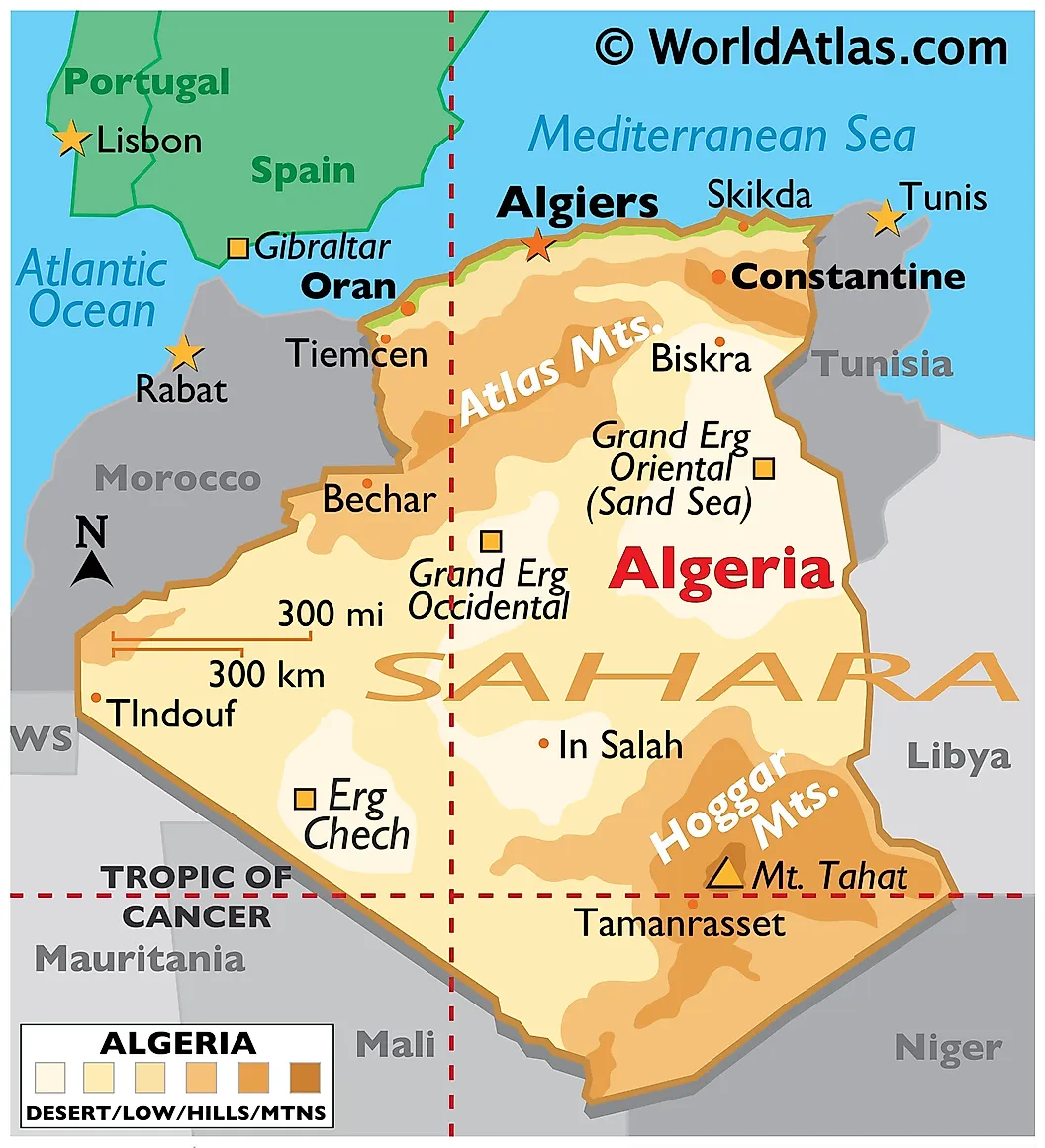
10. Algeria - 2,381,741 km2
- Population: 46 million
- Time Zones: UTC +1:00
Algeria, the largest country in Africa and the 10th largest globally, spans 2.38 million km² in North Africa. Bordered by the Mediterranean Sea to the north and the Sahara Desert to the south, it shares land borders with seven countries, including Morocco, Libya, and Mali. Over 80% of Algeria’s land is desert, and much of it lies within the vast and varied Sahara.
The northern region, known as the Tell, contains the fertile coastal plain and the Tell Atlas mountains. This area supports the majority of Algeria’s population and agriculture, with cities like Algiers and Oran thriving along the Mediterranean. Inland, the High Plateaus and Saharan Atlas feature arid plains and mountain ranges, including grazing lands and scattered oases.
In the south, the Algerian Sahara is characterized by ergs (sand seas), rocky hamadas, and the dramatic Ahaggar Mountains, home to Mount Tahat, the country’s highest point at 3,003 meters. The region includes unique features such as the Tassili n'Ajjer plateau, a UNESCO World Heritage site.
Algeria's climate ranges from Mediterranean in the north to arid in the desert interior. Natural resources like oil, gas, and minerals are abundant, but environmental issues, desertification, water scarcity, and pollution, pose growing challenges.
Countries In the World Ranked By Total Area
| Rank | Country | Total Area (Km²) | Total Area (mi²) | World Share |
|---|---|---|---|---|
| 1 | Russia | 17,098,242 | 6,601,665 | 11.00% |
| 2 | Canada | 9,984,670 | 3,855,101 | 6.11% |
| 3 | China | 9,706,961 | 3,747,877 | 6.30% |
| 4 | United States | 9,372,610 | 3,618,783 | 6.14% |
| 5 | Brazil | 8,515,767 | 3,287,955 | 5.61% |
| 6 | Australia | 7,692,024 | 2,969,906 | 5.16% |
| 7 | India | 3,287,590 | 1,269,345 | 2.00% |
| 8 | Argentina | 2,780,400 | 1,073,518 | 1.84% |
| 9 | Kazakhstan | 2,724,900 | 1,052,089 | 1.81% |
| 10 | Algeria | 2,381,741 | 919,595 | 1.60% |
| 11 | DR Congo | 2,344,858 | 905,354 | 1.52% |
| 12 | Greenland | 2,166,086 | 836,330 | 0.28% |
| 13 | Saudi Arabia | 2,149,690 | 830,000 | 1.44% |
| 14 | Mexico | 1,964,375 | 758,449 | 1.31% |
| 15 | Indonesia | 1,904,569 | 735,358 | 1.22% |
| 16 | Sudan | 1,886,068 | 728,215 | 1.19% |
| 17 | Libya | 1,759,540 | 679,362 | 1.18% |
| 18 | Iran | 1,648,195 | 636,371 | 1.09% |
| 19 | Mongolia | 1,564,110 | 603,906 | 1.04% |
| 20 | Peru | 1,285,216 | 496,224 | 0.86% |
| 21 | Chad | 1,284,000 | 495,755 | 0.85% |
| 22 | Niger | 1,267,000 | 489,191 | 0.85% |
| 23 | Angola | 1,246,700 | 481,353 | 0.84% |
| 24 | Mali | 1,240,192 | 478,841 | 0.82% |
| 25 | South Africa | 1,221,037 | 471,445 | 0.81% |
| 26 | Colombia | 1,141,748 | 440,831 | 0.74% |
| 27 | Ethiopia | 1,104,300 | 426,372 | 0.67% |
| 28 | Bolivia | 1,098,581 | 424,164 | 0.73% |
| 29 | Mauritania | 1,030,700 | 397,955 | 0.69% |
| 30 | Egypt | 1,002,450 | 387,048 | 0.67% |
| 31 | Tanzania | 945,087 | 364,900 | 0.59% |
| 32 | Nigeria | 923,768 | 356,669 | 0.61% |
| 33 | Venezuela | 916,445 | 353,841 | 0.59% |
| 34 | Pakistan | 881,912 | 340,508 | 0.52% |
| 35 | Namibia | 825,615 | 318,772 | 0.55% |
| 36 | Mozambique | 801,590 | 309,496 | 0.53% |
| 37 | Turkey | 783,562 | 302,535 | 0.52% |
| 38 | Chile | 756,102 | 291,932 | 0.50% |
| 39 | Zambia | 752,612 | 290,585 | 0.50% |
| 40 | Myanmar | 676,578 | 261,228 | 0.44% |
| 41 | Afghanistan | 652,230 | 251,827 | 0.44% |
| 42 | Somalia | 637,657 | 246,201 | 0.42% |
| 43 | Central African Republic | 622,984 | 240,535 | 0.42% |
| 44 | South Sudan | 619,745 | 239,285 | 0.41% |
| 45 | Ukraine | 603,500 | 233,013 | 0.39% |
| 46 | Madagascar | 587,041 | 226,658 | 0.39% |
| 47 | Botswana | 582,000 | 224,711 | 0.38% |
| 48 | Kenya | 580,367 | 224,081 | 0.38% |
| 49 | France | 551,695 | 213,011 | 0.37% |
| 50 | Yemen | 527,968 | 203,850 | 0.35% |
| 51 | Thailand | 513,120 | 198,117 | 0.34% |
| 52 | Spain | 505,992 | 195,365 | 0.33% |
| 53 | Turkmenistan | 488,100 | 188,456 | 0.32% |
| 54 | Cameroon | 475,442 | 183,569 | 0.32% |
| 55 | Papua New Guinea | 462,840 | 178,703 | 0.30% |
| 56 | Sweden | 450,295 | 173,860 | 0.28% |
| 57 | Uzbekistan | 447,400 | 172,742 | 0.29% |
| 58 | Morocco | 446,550 | 172,414 | 0.30% |
| 59 | Iraq | 438,317 | 169,235 | 0.29% |
| 60 | Paraguay | 406,752 | 157,048 | 0.27% |
| 61 | Zimbabwe | 390,757 | 150,872 | 0.26% |
| 62 | Japan | 377,930 | 145,920 | 0.24% |
| 63 | Germany | 357,114 | 137,882 | 0.23% |
| 64 | Philippines | 342,353 | 132,183 | 0.20% |
| 65 | Congo | 342,000 | 132,047 | 0.23% |
| 66 | Finland | 338,424 | 130,666 | 0.20% |
| 67 | Vietnam | 331,212 | 127,882 | 0.21% |
| 68 | Malaysia | 330,803 | 127,724 | 0.22% |
| 69 | Norway | 323,802 | 125,021 | 0.25% |
| 70 | Côte d'Ivoire | 322,463 | 124,504 | 0.21% |
| 71 | Poland | 312,679 | 120,726 | 0.21% |
| 72 | Oman | 309,500 | 119,499 | 0.21% |
| 73 | Italy | 301,336 | 116,346 | 0.20% |
| 74 | Ecuador | 276,841 | 106,889 | 0.17% |
| 75 | Burkina Faso | 272,967 | 105,393 | 0.18% |
| 76 | New Zealand | 270,467 | 104,428 | 0.18% |
| 77 | Gabon | 267,668 | 103,347 | 0.17% |
| 78 | Western Sahara | 266,000 | 102,703 | 0.18% |
| 79 | Guinea | 245,857 | 94,926 | 0.16% |
| 80 | United Kingdom | 242,900 | 93,784 | 0.16% |
| 81 | Uganda | 241,550 | 93,263 | 0.13% |
| 82 | Ghana | 238,533 | 92,098 | 0.15% |
| 83 | Romania | 238,391 | 92,043 | 0.15% |
| 84 | Laos | 236,800 | 91,429 | 0.15% |
| 85 | Guyana | 214,969 | 83,000 | 0.13% |
| 86 | Belarus | 207,600 | 80,155 | 0.14% |
| 87 | Kyrgyzstan | 199,951 | 77,201 | 0.13% |
| 88 | Senegal | 196,722 | 75,955 | 0.13% |
| 89 | Syria | 185,180 | 71,498 | 0.12% |
| 90 | Cambodia | 181,035 | 69,898 | 0.12% |
| 91 | Uruguay | 181,034 | 69,898 | 0.12% |
| 92 | Suriname | 163,820 | 63,251 | 0.10% |
| 93 | Tunisia | 163,610 | 63,170 | 0.10% |
| 94 | Bangladesh | 147,570 | 56,977 | 0.09% |
| 95 | Nepal | 147,181 | 56,827 | 0.10% |
| 96 | Tajikistan | 143,100 | 55,251 | 0.09% |
| 97 | Greece | 131,990 | 50,962 | 0.09% |
| 98 | Nicaragua | 130,373 | 50,337 | 0.08% |
| 99 | North Korea | 120,538 | 46,540 | 0.08% |
| 100 | Malawi | 118,484 | 45,747 | 0.06% |
| 101 | Eritrea | 117,600 | 45,406 | 0.07% |
| 102 | Benin | 112,622 | 43,484 | 0.08% |
| 103 | Honduras | 112,492 | 43,433 | 0.08% |
| 104 | Liberia | 111,369 | 43,000 | 0.07% |
| 105 | Bulgaria | 110,879 | 42,811 | 0.07% |
| 106 | Cuba | 109,884 | 42,426 | 0.07% |
| 107 | Guatemala | 108,889 | 42,042 | 0.07% |
| 108 | Iceland | 103,000 | 39,769 | 0.07% |
| 109 | South Korea | 100,210 | 38,691 | 0.07% |
| 110 | Hungary | 93,028 | 35,918 | 0.06% |
| 111 | Portugal | 92,090 | 35,556 | 0.06% |
| 112 | Jordan | 89,342 | 34,495 | 0.06% |
| 113 | Serbia | 88,361 | 34,116 | 0.06% |
| 114 | Azerbaijan | 86,600 | 33,436 | 0.06% |
| 115 | Austria | 83,871 | 32,383 | 0.06% |
| 116 | United Arab Emirates | 83,600 | 32,278 | 0.06% |
| 117 | French Guiana | 83,534 | 32,253 | 0.06% |
| 118 | Czechia | 78,865 | 30,450 | 0.05% |
| 119 | Panama | 75,417 | 29,119 | 0.05% |
| 120 | Sierra Leone | 71,740 | 27,699 | 0.05% |
| 121 | Ireland | 70,273 | 27,133 | 0.05% |
| 122 | Georgia | 69,700 | 26,911 | 0.05% |
| 123 | Sri Lanka | 65,610 | 25,332 | 0.04% |
| 124 | Lithuania | 65,300 | 25,212 | 0.04% |
| 125 | Latvia | 64,559 | 24,926 | 0.04% |
| 126 | Togo | 56,785 | 21,925 | 0.04% |
| 127 | Croatia | 56,594 | 21,851 | 0.04% |
| 128 | Bosnia and Herzegovina | 51,209 | 19,772 | 0.03% |
| 129 | Costa Rica | 51,100 | 19,730 | 0.03% |
| 130 | Slovakia | 49,037 | 18,933 | 0.03% |
| 131 | Dominican Republic | 48,671 | 18,792 | 0.03% |
| 132 | Estonia | 45,227 | 17,462 | 0.03% |
| 133 | Denmark | 43,094 | 16,639 | 0.03% |
| 134 | Netherlands | 41,850 | 16,158 | 0.02% |
| 135 | Switzerland | 41,284 | 15,940 | 0.03% |
| 136 | Bhutan | 38,394 | 14,824 | 0.03% |
| 137 | Taiwan | 36,193 | 13,974 | 0.02% |
| 138 | Guinea-Bissau | 36,125 | 13,948 | 0.02% |
| 139 | Moldova | 33,846 | 13,068 | 0.02% |
| 140 | Belgium | 30,528 | 11,787 | 0.02% |
| 141 | Lesotho | 30,355 | 11,720 | 0.02% |
| 142 | Armenia | 29,743 | 11,484 | 0.02% |
| 143 | Solomon Islands | 28,896 | 11,157 | 0.02% |
| 144 | Albania | 28,748 | 11,100 | 0.02% |
| 145 | Equatorial Guinea | 28,051 | 10,831 | 0.02% |
| 146 | Burundi | 27,834 | 10,747 | 0.02% |
| 147 | Haiti | 27,750 | 10,714 | 0.02% |
| 148 | Rwanda | 26,338 | 10,169 | 0.02% |
| 149 | Republic of North Macedonia | 25,713 | 9,928 | 0.02% |
| 150 | Djibouti | 23,200 | 8,958 | 0.02% |
| 151 | Belize | 22,966 | 8,867 | 0.02% |
| 152 | El Salvador | 21,041 | 8,124 | 0.01% |
| 153 | Israel | 20,770 | 8,019 | 0.02% |
| 154 | Slovenia | 20,273 | 7,827 | 0.01% |
| 155 | New Caledonia | 18,575 | 7,172 | 0.01% |
| 156 | Fiji | 18,272 | 7,055 | 0.01% |
| 157 | Kuwait | 17,818 | 6,880 | 0.01% |
| 158 | Eswatini | 17,364 | 6,704 | 0.01% |
| 159 | Timor-Leste | 14,874 | 5,743 | 0.01% |
| 160 | Bahamas | 13,943 | 5,383 | 0.01% |
| 161 | Montenegro | 13,812 | 5,333 | 0.01% |
| 162 | Vanuatu | 12,189 | 4,706 | 0.01% |
| 163 | Falkland Islands | 12,173 | 4,700 | 0.01% |
| 164 | Qatar | 11,586 | 4,473 | 0.01% |
| 165 | Jamaica | 10,991 | 4,244 | 0.01% |
| 166 | Gambia | 10,689 | 4,127 | 0.01% |
| 167 | Lebanon | 10,452 | 4,036 | 0.01% |
| 168 | Cyprus | 9,251 | 3,572 | 0.01% |
| 169 | Puerto Rico | 8,870 | 3,425 | 0.01% |
| 170 | State of Palestine | 6,220 | 2,402 | 0.00% |
| 171 | Brunei Darussalam | 5,765 | 2,226 | 0.00% |
| 172 | Trinidad and Tobago | 5,130 | 1,981 | 0.00% |
| 173 | French Polynesia | 4,167 | 1,609 | 0.00% |
| 174 | Cabo Verde | 4,033 | 1,557 | 0.00% |
| 175 | Samoa | 2,842 | 1,097 | 0.00% |
| 176 | Luxembourg | 2,586 | 998 | 0.00% |
| 177 | Réunion | 2,511 | 970 | 0.00% |
| 178 | Mauritius | 2,040 | 788 | 0.00% |
| 179 | Comoros | 1,862 | 719 | 0.00% |
| 180 | Guadeloupe | 1,628 | 629 | 0.00% |
| 181 | Faeroe Islands | 1,393 | 538 | 0.00% |
| 182 | Martinique | 1,128 | 436 | 0.00% |
| 183 | China, Hong Kong SAR | 1,104 | 426 | 0.00% |
| 184 | Sao Tome and Principe | 964 | 372 | 0.00% |
| 185 | Turks and Caicos Islands | 948 | 366 | 0.00% |
| 186 | Kiribati | 811 | 313 | 0.00% |
| 187 | Bahrain | 765 | 295 | 0.00% |
| 188 | Dominica | 751 | 290 | 0.00% |
| 189 | Tonga | 747 | 288 | 0.00% |
| 190 | Singapore | 710 | 274 | 0.00% |
| 191 | Micronesia | 702 | 271 | 0.00% |
| 192 | Saint Lucia | 616 | 238 | 0.00% |
| 193 | Isle of Man | 572 | 221 | 0.00% |
| 194 | Guam | 549 | 212 | 0.00% |
| 195 | Andorra | 468 | 181 | 0.00% |
| 196 | Northern Mariana Islands | 464 | 179 | 0.00% |
| 197 | Palau | 459 | 177 | 0.00% |
| 198 | Seychelles | 452 | 175 | 0.00% |
| 199 | Curaçao | 444 | 171 | 0.00% |
| 200 | Antigua and Barbuda | 442 | 171 | 0.00% |
| 201 | Barbados | 430 | 166 | 0.00% |
| 202 | Saint Helena | 394 | 152 | 0.00% |
| 203 | Saint Vincent and the Grenadines | 389 | 150 | 0.00% |
| 204 | Mayotte | 374 | 144 | 0.00% |
| 205 | United States Virgin Islands | 347 | 134 | 0.00% |
| 206 | Grenada | 344 | 133 | 0.00% |
| 207 | Caribbean Netherlands | 328 | 127 | 0.00% |
| 208 | Malta | 316 | 122 | 0.00% |
| 209 | Maldives | 300 | 116 | 0.00% |
| 210 | Cayman Islands | 264 | 102 | 0.00% |
| 211 | Saint Kitts and Nevis | 261 | 101 | 0.00% |
| 212 | Niue | 260 | 100 | 0.00% |
| 213 | Saint Pierre and Miquelon | 242 | 93 | 0.00% |
| 214 | Cook Islands | 236 | 91 | 0.00% |
| 215 | American Samoa | 199 | 77 | 0.00% |
| 216 | Marshall Islands | 181 | 70 | 0.00% |
| 217 | Aruba | 180 | 69 | 0.00% |
| 218 | Liechtenstein | 160 | 62 | 0.00% |
| 219 | British Virgin Islands | 151 | 58 | 0.00% |
| 220 | Wallis and Futuna Islands | 142 | 55 | 0.00% |
| 221 | Montserrat | 102 | 39 | 0.00% |
| 222 | Anguilla | 91 | 35 | 0.00% |
| 223 | San Marino | 61 | 24 | 0.00% |
| 224 | Bermuda | 54 | 21 | 0.00% |
| 225 | Saint Martin | 53 | 20 | 0.00% |
| 226 | Sint Maarten | 34 | 13 | 0.00% |
| 227 | China, Macao SAR | 30 | 12 | 0.00% |
| 228 | Tuvalu | 26 | 10 | 0.00% |
| 229 | Nauru | 21 | 8 | 0.00% |
| 230 | Saint Barthélemy | 21 | 8 | 0.00% |
| 231 | Tokelau | 12 | 5 | 0.00% |
| 232 | Gibraltar | 6 | 2 | 0.00% |
| 233 | Monaco | 2 | 1 | 0.00% |
| 234 | Holy See | 0 | 0 | 0.00% |
Total Area is the combined value of a country's land area and water area. Data is sourced from The World Bank and CIA World Factbook.