The US Lakes With the Worst Algae Blooms
In August 2014, a toxic algal bloom near Toledo's Lake Erie water intake forced the city to issue a "do not drink" advisory to roughly half a million customers for two and a half days. That event made national news, but it was not unusual: the same kind of bloom returns to the western basin of Lake Erie every summer, and similar problems recur on shallow, nutrient-loaded lakes across the country. Harmful algal blooms (HABs), produced mainly by cyanobacteria (often called blue-green algae), can release liver toxins, neurotoxins, and skin irritants into water that ordinary boiling will not remove. The five US lakes below are the country's most consistently and severely affected. Each shares the same combination of factors: shallow water that warms quickly through the summer, watersheds heavy with agricultural runoff, and decades of altered hydrology that has left the lakes hyper-fed and underflushed.
Lake Erie's Western Basin

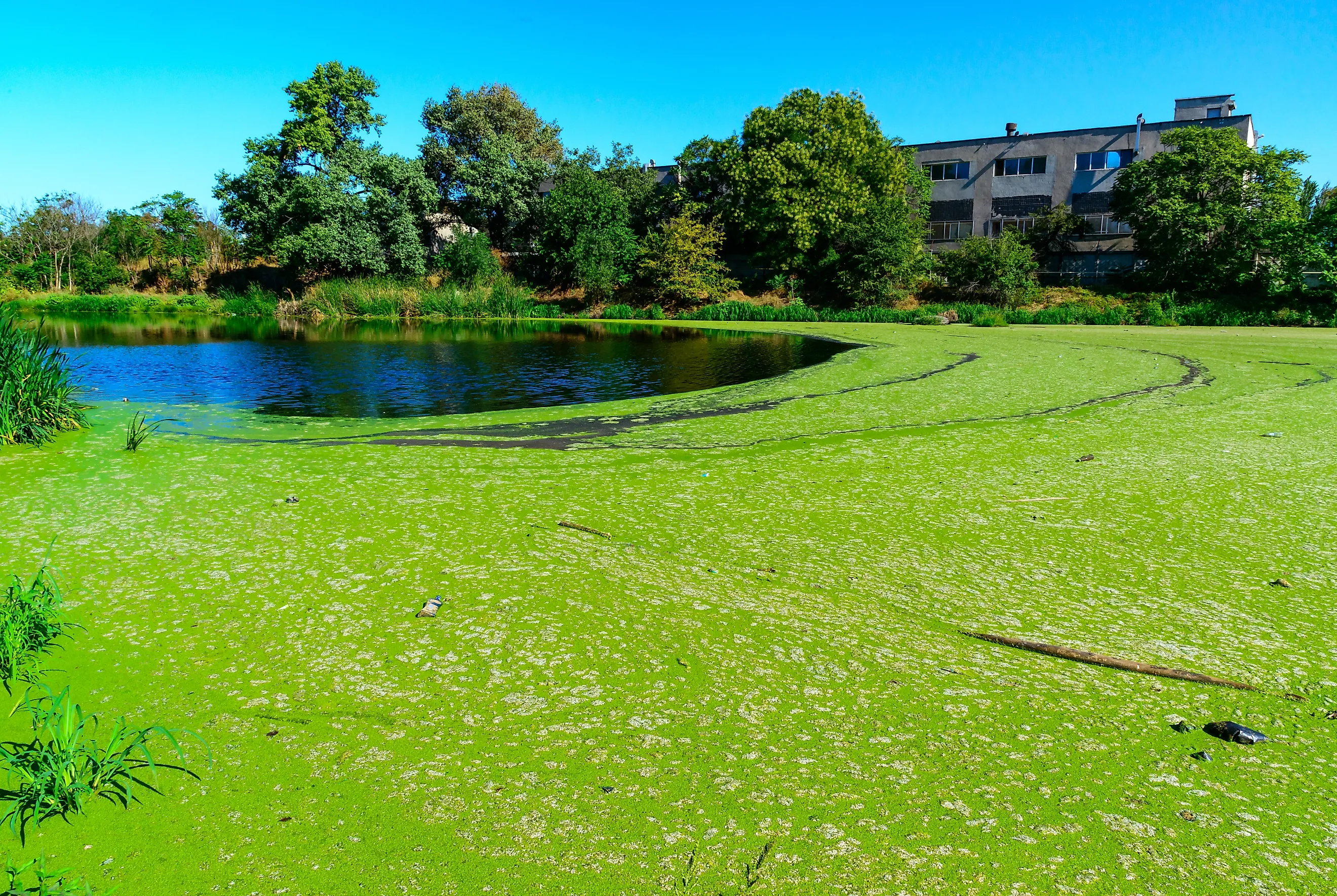
Lake Erie is the shallowest of the Great Lakes, with a maximum depth of 210 feet (64 m) and an overall average of 62 feet (19 m). The western basin, which carries the worst of the bloom problem, averages only about 24 feet. Shallow, slow-flushing water that warms quickly through the summer is half the problem. The other half is nutrient input. The Maumee River, which drains roughly 6,500 square miles of cropland in Ohio, Michigan, and Indiana, carries a large soluble-phosphorus load into the western basin every spring, mostly from agricultural fertilizer and manure runoff. Soluble phosphorus loads on the Maumee in spring are the single best statistical predictor of bloom severity that summer.
The blooms produce microcystin, a cyanobacterial liver toxin that conventional drinking-water treatment does not fully remove at high concentrations. In August 2014, microcystin made it through the Toledo Water Treatment Plant's filtration process, and the city issued a "do not drink" advisory to about 500,000 customers in Ohio and Michigan. The advisory ran 55 hours. The 2011 Lake Erie bloom set what was then the severity record at index 10 on NOAA's biomass-based scale and covered about 2,000 square miles at peak. The 2015 bloom exceeded that, scoring 10.5 (the highest ever recorded). Dense surface scum at peak in 2015 covered up to 300 square miles of the western basin. NOAA still issues annual bloom forecasts each summer; recent years have measured between 3 and 8 on the same scale.
Lake Okeechobee, Florida
Lake Okeechobee is the largest lake in Florida and in the southeastern United States, and the second-largest natural freshwater lake contained entirely within the contiguous 48 states (Lake Michigan is larger but borders four states). It covers 730 square miles (1,900 km²), runs about 35 miles north to south, and is exceptionally shallow for its size, with an average depth of 9 feet and a maximum near 13 feet. Shallow, warm water plus a heavily fertilized watershed makes it ideal cyanobacterial habitat.
The lake sits at the head of the Everglades and receives most of its water from the Kissimmee River, which drains roughly 4,400 square miles of agricultural and pasture land. Total phosphorus loading runs about 600 metric tons per year. Bloom intensity varies sharply year to year. The 2018 event covered most of the lake at peak, and bloom-laden water released through the St. Lucie and Caloosahatchee canals fouled estuaries on both Florida coasts and triggered fish kills downstream. The Florida Department of Health has issued near-continuous algal-bloom precautions for various sites on Okeechobee through 2024 and 2025. Standing advisories tell residents and visitors not to swim, wade, or drink the water where blooms are visible, and not to let pets or livestock drink it; boiling does not break down the toxins, and may concentrate them.
Clear Lake, California

Clear Lake, in Lake County north of Napa, is the largest natural freshwater lake entirely within California (Lake Tahoe straddles the California-Nevada border). It covers 68 square miles (176 km²), measures 19 miles long by 8 miles wide at its widest, and averages 27 feet (8.2 m) deep with a maximum of 60 feet (18 m). Geologists describe Clear Lake as one of the oldest lakes in North America. The current lake basin is about 480,000 years old, and lakes have occupied this same patch of ground for roughly 2.5 million years thanks to a slow tectonic tilt that keeps the basin filling with water as fast as it fills with sediment.
Its algal-bloom record is among the country's longest. Written observations of cloudy, scummy summer water at the lake date to the 1870s. The lake is naturally eutrophic to begin with: shallow, mineral-rich, and warm in summer, all of which favor cyanobacteria. Wetland loss around the shoreline through the 20th century, driven by orchards, mercury mining (the abandoned Sulphur Bank Mine is a Superfund site), and residential development, removed much of the natural nutrient buffer. Modern agricultural runoff continues to feed the blooms, which produce green and white algal scums and the smells that come with them through every summer.
Over 60% of Lake County residents draw drinking water from the lake. Public utilities treat for cyanotoxins, but private intakes do not always test, and during severe blooms many residents switch to bottled water for cooking, drinking, and washing dishes. Boiling makes the problem worse rather than better; it concentrates microcystin instead of destroying it. On windy days during heavy blooms, aerosolized droplets carrying toxin can also irritate the lungs of people living or working near the shore.
Utah Lake, Utah

Utah Lake covers about 150 square miles (389 km²) in Utah Valley, with Provo on its eastern shore. It runs roughly 24 miles (39 km) north to south and 13 miles (21 km) east to west, and averages just 9 feet (2.7 m) deep, with a maximum of about 14 feet (4.3 m). It is shallow even by Utah standards.
Algal blooms have been documented on Utah Lake for well over a century. Decades of agricultural runoff, sewage discharge, and industrial pollution have built phosphorus and nitrogen levels in the water column. The introduction of common carp in the late 1800s made things worse. Carp are bottom feeders that uproot submerged vegetation and stir up sediment, keeping phosphorus suspended in the water column instead of locked away on the lakebed. The Utah Lake Authority has removed roughly 75% of the carp population through ongoing trapping programs, and bloom-affected periods have shortened, but lakewide warning advisories still recur most summers.
When blooms are active, the Utah Department of Environmental Quality advises against all water contact at affected sites, and wave-runner activity is specifically discouraged because the spray can aerosolize toxins. Anglers are told to discard the fish's skin and guts (cyanotoxins concentrate in those tissues) and to keep all pets and livestock away from the shoreline. Dogs have died in Utah after exposure to bloom water at other affected sites in the state, including Mantua Reservoir and a stream in Zion National Park.
Klamath Lake, Oregon

Upper Klamath Lake (commonly shortened to "Klamath Lake") is the largest freshwater body by surface area in Oregon, at roughly 96 square miles (250 km²). It runs about 25 miles (40 km) long and 8 miles (13 km) wide, sits at 4,140 feet of elevation in the Klamath Graben east of the Cascade Range, and is shallow throughout. The average depth depends on regulation by the Link River Dam but commonly sits around 8 feet (2.4 m), with localized trenches reaching 50 feet (15 m). The combination of shallow water and warm summer temperatures sets up the conditions cyanobacteria need to dominate.
The dominant bloom species at Klamath is Aphanizomenon flos-aquae, which has been the lake's defining cyanobacterial presence since the mid-20th century. Phosphorus comes from a watershed of 3,768 square miles, including agricultural land, livestock grazing, and former wetlands now drained for farming. The lake also generates internal phosphorus loading: nutrient-rich sediments laid down when the area was a much larger pluvial lake (Lake Modoc) keep releasing phosphorus into the water column today.
When the Oregon Health Authority finds toxin levels above advisory thresholds, it warns against swimming, water-skiing, and other contact recreation. The blooms also do real biological damage. Lost River and shortnose suckers, federally listed as endangered in 1988, experience juvenile die-offs when bloom decomposition pushes pH up to 10 and crashes dissolved oxygen in late summer. Without those bottom-feeding native suckers in their historical numbers, one of the lake's natural pathways for nutrient cycling has been weakened, which makes the bloom problem harder to break.
What These Lakes Have In Common
All five lakes share the same recipe: water shallow enough to warm up fast in summer, watersheds saturated with phosphorus from a century or more of agricultural runoff, and altered hydrology (drained wetlands, regulated outflows, introduced or removed species) that has stripped out the natural buffers. The blooms have economic and ecological consequences beyond the obvious aesthetic and recreational ones: drinking-water disruption in cities like Toledo, fish kills and federally endangered species made more endangered, lost summer tourism, and aerosolized toxins that affect people who live near the shore even without entering the water. Most of the underlying drivers are well understood. The harder problem has been agreeing on who pays to fix them.


