Rivers That Flow North
Down does not mean south. The Nile flows north for thousands of miles before emptying into the Mediterranean. The Mackenzie does the same in Canada on its way to the Arctic Ocean. Russia's Ob, Yenisey, and Lena all flow north across Siberia to the Arctic. At least 48 rivers in 16 American states flow north, with the highest counts in Alaska, Washington, and New York. Rivers follow gravity, not the compass.
- Why Some Rivers Flow North
- How Many Rivers Flow North?
- Famous Rivers That Flow North
- Do Rivers Usually Flow South?
- Why North-Flowing Rivers Matter
Why Some Rivers Flow North

If a river's source is south of its mouth and the land slopes downward toward the north, the river will flow north. The direction has nothing to do with the equator, the poles, or the way maps are drawn.
Mountains, plateaus, glacial valleys, rift basins, and coastal plains all help determine the course of a river. A river that begins in a southern highland may move north simply because that is where the land descends. In other places, a river may follow an ancient valley carved by glaciers or curve around resistant rock before turning in another direction. Rivers rarely travel in perfectly straight lines. Many meander across floodplains, curve around hills, or shift direction as tributaries join them. When a river is described as "north-flowing," it usually means that its overall course, or a major part of its course, moves toward the north.
How Many Rivers Flow North?

There is no confirmed worldwide count. The answer depends on how "river" is defined and whether the count includes only major rivers, smaller rivers, tributaries, or individual river segments. A river may also flow north for part of its course but turn east or west before reaching its mouth.
The idea that only the Nile and Florida's St. Johns flow north is a popular misconception. In the United States alone, at least 48 rivers in 16 states flow north, including roughly nine in Alaska, eight in Washington, and six in New York. North-flowing rivers appear across North America, South America, Africa, Europe, and Asia. They are not geographic oddities. What makes them interesting is what they reveal: local topography, not hemisphere or latitude, controls the movement of water.
Famous Rivers That Flow North
Some of the world's best-known north-flowing rivers are major waterways with enormous drainage basins, long histories of human settlement, or important roles in transportation and ecology. The examples below include rivers that flow generally north for most of their course, plus rivers with major northward sections.
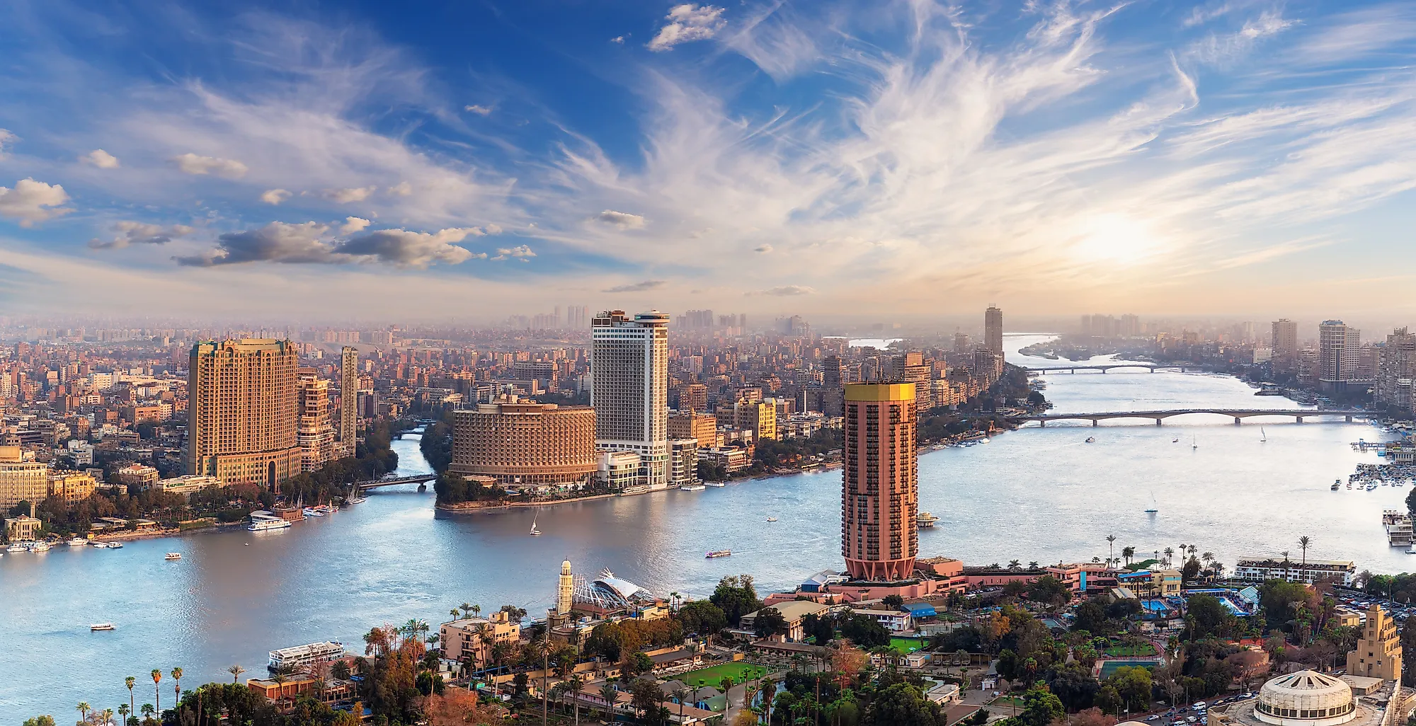
Nile River, Africa

The Nile is the most famous example of a river that flows north. It rises south of the Equator and runs generally northward through northeastern Africa before emptying into the Mediterranean Sea. Its major tributaries include the White Nile and Blue Nile, which meet at Khartoum in Sudan before the river continues north through Egypt.
The Nile has shaped life in northeastern Africa for thousands of years. In Egypt, its annual floods historically deposited fertile silt along the valley and delta, supporting agriculture in an otherwise dry region. The river also served as a transportation corridor linking interior regions with the Mediterranean world. Its length is most often given as around 4,130 miles (6,650 kilometers) from its remotest headstream to the Mediterranean, though measurements vary depending on which headstream is used.
Ob River, Russia

The Ob River is one of Siberia's largest rivers and one of Asia's major river systems. It forms in the Altai region of Russia at the confluence of the Biya and Katun rivers, then flows generally north and west across western Siberia. Eventually, it empties into the Gulf of Ob and the Kara Sea, part of the Arctic Ocean.
The Ob is especially important because of its huge drainage basin. Counted with its major tributary, the Irtysh, the Ob-Irtysh system is one of the longest river systems in the world. Its course crosses lowlands, wetlands, taiga forests, and tundra, making it a defining feature of western Siberia.
Yenisey River, Russia/Mongolia

The Yenisey is another major Siberian river that flows generally north. It rises in the borderland of south-central Russia and Mongolia and runs through central Siberia before emptying into the Kara Sea. Along with the Ob and the Lena, it is one of Russia's main Arctic-draining rivers.
The Yenisey is notable for the size of its basin and the volume of water it carries. By annual discharge, it is the largest river in Russia. It receives several major tributaries, including the Angara, which drains Lake Baikal. Its northward course links southern Siberia with the Arctic coast and passes through some of Russia's most remote landscapes.
Lena River, Russia

The Lena River flows generally northward across eastern Siberia. It begins in the mountains near Lake Baikal and travels roughly 2,734 miles (4,400 kilometers) before reaching its large delta on the Laptev Sea, an arm of the Arctic Ocean.
The Lena is one of the longest rivers in the world and the largest river in the world that lies entirely within Russia. Its basin includes permafrost regions, boreal forests, tundra, and seasonal wetlands. Like other Arctic-draining rivers, the Lena experiences major spring flooding when upstream snowmelt moves north into areas where the lower river remains frozen.
Mackenzie River, Canada
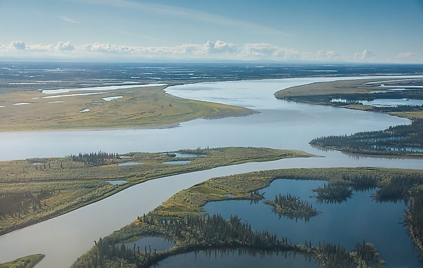
The Mackenzie River is Canada's main north-flowing river system. The river proper flows northward from Great Slave Lake through the Northwest Territories and empties into the Beaufort Sea of the Arctic Ocean. Including the Finlay River as its farthest headstream, the Mackenzie system is the longest river system in Canada at roughly 2,635 miles (4,241 kilometers).
The Mackenzie drains a huge portion of northwestern Canada and passes through forests, wetlands, tundra, and sparsely populated northern communities. Its delta is one of the largest Arctic deltas in North America and provides important habitat for fish, birds, and other wildlife.
North-Flowing Rivers in the United States
The United States has many rivers that flow north for all or part of their courses. Some are famous regional waterways, while others are smaller rivers and tributaries. The examples below show that north-flowing rivers occur in very different landscapes, from Florida wetlands to Appalachian valleys and the Pacific Northwest.
St. Johns River, Florida

The St. Johns River is one of the best-known north-flowing rivers in the United States. It is Florida's longest river at 310 miles, beginning in marshes south of Melbourne and flowing northward across central Florida before turning east near Jacksonville and emptying into the Atlantic Ocean.
The St. Johns is also one of the slowest rivers in the world. Its headwaters sit only about 27 feet higher than its mouth, an average drop of about one inch per mile over its full length. That low gradient produces broad lakes, marshes, and wetlands along the river, making it important habitat for fish, birds, alligators, and manatees.
Red River of the North, Minnesota/North Dakota/Manitoba

The Red River of the North begins at the confluence of the Bois de Sioux and Otter Tail rivers near the Minnesota-North Dakota border. From there it flows north through the Red River Valley, forming much of the boundary between Minnesota and North Dakota before continuing into Manitoba and emptying into Lake Winnipeg.
This river is especially known for flooding. Its basin is very flat because it lies on the former bed of glacial Lake Agassiz. In spring, snow often melts first in the southern part of the basin and flows north toward areas that may still be frozen, increasing the risk of ice jams and floods.
Willamette River, Oregon

The Willamette River flows north through western Oregon's Willamette Valley. It is formed by forks rising in the mountains south and southeast of Eugene, then runs past Eugene, Corvallis, Albany, Salem, and Oregon City before joining the Columbia River near Portland.
The Willamette is one of Oregon's most important rivers. Its valley contains some of the state's most productive farmland, major population centers, and a well-known wine region. The river's northward course reflects the shape of the valley between the Oregon Coast Range to the west and the Cascade Range to the east.
Genesee River, New York

The Genesee River rises in northern Pennsylvania and flows generally north through western New York before entering Lake Ontario at Rochester. It is about 157 miles long and is one of the relatively few major rivers in New York that drain northward into the Great Lakes.
The Genesee is known for its gorges and waterfalls. In Letchworth State Park, often called the "Grand Canyon of the East," the river cuts through a deep gorge and drops over major falls. Farther north, it passes through Rochester, where additional waterfalls helped power the city's early industrial development.
New River, North Carolina/Virginia/West Virginia

The New River begins in northwestern North Carolina and flows north across Virginia into West Virginia. It eventually joins the Gauley River to form the Kanawha, part of the larger Ohio River system.
Despite its name, the New River follows a very old landscape and is often described as one of the oldest river systems in North America. Its northward course through the Appalachians is unusual compared with most nearby streams, and its gorge in West Virginia is now protected as part of New River Gorge National Park and Preserve.
Monongahela River, West Virginia/Pennsylvania

The Monongahela River forms in northern West Virginia where the Tygart Valley and West Fork rivers meet. It flows north into Pennsylvania, passing Morgantown, Brownsville, and other river towns before joining the Allegheny River at Pittsburgh to form the Ohio River.
The Monongahela has long been important for transportation, industry, and settlement in the Appalachian Plateau. Its valley became closely tied to coal, steel, river navigation, and the growth of Pittsburgh. It is a clear example of a river that flows north because the regional terrain slopes that way toward its confluence.
Withlacoochee River, Florida

The Withlacoochee River in central Florida is another Florida river with a notable northward course. It begins in the Green Swamp, flows west and north through central Florida, then bends west again before reaching the Gulf Coast near Yankeetown.
The river's name is often interpreted as "crooked river," which fits its winding path. Its northward sections pass through wetlands, forests, and rural landscapes, and the river is associated with paddling trails and conservation lands across the broader Withlacoochee watershed.
North-Flowing Rivers in South America
South America has many rivers with northward or partly northward courses, especially where the Andes, Guiana Highlands, and large interior basins shape drainage patterns. Some rivers flow north for most of their length, while others flow north for a major segment before turning east toward the Atlantic or the Caribbean.
Orinoco River

The Orinoco is one of South America's largest river systems. It rises in the Guiana Highlands and flows in a broad arc through Venezuela, with part of its course forming the border between Venezuela and Colombia. In its upper and middle sections, the river includes important northward stretches before turning east and eventually reaching the Atlantic Ocean near Trinidad.
The Orinoco basin is ecologically rich, supporting seasonally flooded plains, forests, wetlands, and diverse aquatic life. Because the river curves across northern South America rather than following one straight direction, it is best described as a river with major northward sections rather than a river that flows north from source to mouth.
Magdalena River
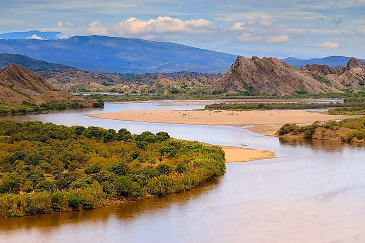
The Magdalena is Colombia's principal river and one of the clearest South American examples of a river that flows north from source to mouth. It rises in the Andes and flows generally north for about 950 miles (1,528 kilometers) before emptying into the Caribbean Sea.
The Magdalena has played a central role in Colombia's history, economy, and transportation. Its valley links the Andean interior with the Caribbean coast, and many of Colombia's major cities and agricultural regions developed within its broader basin.
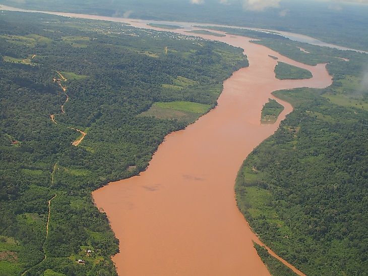
Essequibo River

The Essequibo is the largest river in Guyana and one of the major rivers of the Guianas. It rises in the Acarai Mountains near the Brazil-Guyana border and flows north for about 630 miles (1,010 kilometers) through forests and savannas before reaching the Atlantic Ocean.
The river's wide estuary lies west of Georgetown, Guyana's capital. Along its course, the Essequibo and its tributaries drain remote rainforest regions, support biodiversity, and help define Guyana's identity as a country of many rivers.
Northward-Flowing Tributaries Of The Amazon System
The Amazon River itself flows generally from west to east across northern South America before emptying into the Atlantic Ocean. However, parts of the wider Amazon system include tributaries and headwaters that flow north or northwest before joining larger rivers.
Two important examples are the Ucayali and Marañón rivers in Peru. The Ucayali, one of the Amazon's principal headwaters, runs north through eastern Peru before meeting the Marañón. The Marañón rises in the Andes and flows northwest for a major part of its course before turning toward the Amazon lowlands. These examples show why river direction is often more complex than a single compass label.
Do Rivers Usually Flow South?
Rivers do not flow south by rule. They flow downhill. The belief that rivers should flow south likely comes from the way maps are usually printed, with north at the top and south at the bottom. On a map, south may look like "down," but on Earth, "down" means lower elevation, not lower on the page.
A river in the Northern Hemisphere can flow north if its source is higher than its mouth and the land slopes that way. A river in the Southern Hemisphere can flow north, south, east, or west, depending on local terrain. The same principle applies everywhere: water follows gravity and the shape of the land. This is why the Nile can flow north to the Mediterranean, the Mackenzie can flow north to the Arctic Ocean, and the Willamette can flow north through Oregon. None of these rivers is defying nature. They are simply following the lowest available path.
Why North-Flowing Rivers Matter
North-flowing rivers matter because they shape landscapes, ecosystems, economies, and human settlement just like any other major river. The Nile supported ancient Egyptian agriculture and transportation. The Mackenzie drains a vast part of northwestern Canada. The Magdalena has long connected Colombia's interior with the Caribbean. The Willamette shaped Oregon's most populated valley.
In colder regions, north-flowing rivers can create distinctive flood risks. When snow melts in the warmer southern part of a basin and flows north into colder areas where the river is still frozen, water can back up behind ice and cause flooding. This is one reason the Red River of the North is so closely associated with spring flood events.
These rivers also support wetlands, deltas, fisheries, forests, farms, cities, and transportation routes. Their northward direction may attract curiosity, but their real importance lies in the way they move water, sediment, nutrients, people, and commerce across large regions. North-flowing rivers are not exceptions to geography. They are examples of geography at work. Whether a river flows north, south, east, or west, its course is determined by elevation, geology, climate, and time. The direction may surprise people at first, but the explanation is simple: rivers follow the land.


