15 Most Beautiful Lakes In America
The deepest lake in America is a flooded volcano in Oregon. The cleanest is so pure that a major city drinks it straight from the tap, no filter required. One of them was briefly declared a Great Lake, then quietly un-declared a few weeks later. America's lakes are show-offs, and these fifteen are the best of the bunch, picked for their looks but loaded with stories. Here is where to find them, and the facts that make each one worth the drive.
Lake Champlain, New York/Vermont

Lake Champlain is big enough to have fooled Congress. In 1998 it was briefly designated the nation's sixth Great Lake, a status that lasted about three weeks before lawmakers thought better of it. At roughly 435 square miles it is the largest lake in New England, stretching about 120 miles between Vermont and New York and spilling north across the border into Quebec. The French explorer Samuel de Champlain reached it in 1609 and left his name on it. Today it offers fishing, boating, paddling, and swimming, with state parks ringing the shore: Burton Island and Sand Bar on the Vermont side, Macomb Reservation across in New York. It also shelters more than twenty species of amphibians and reptiles, several of them now threatened or endangered, so the quiet coves do real ecological work.
Lake Eklutna, Alaska

Most lakes on this list are scenery. Eklutna is infrastructure that happens to be beautiful. This seven-mile, glacier-fed lake in Chugach State Park is the main source of Anchorage's drinking water and a chunk of its electricity, which is why no motorboats are allowed to foul its milky turquoise surface. The color comes from glacial flour, rock ground to powder and suspended in the meltwater pouring off Eklutna Glacier at the far end. The Dena'ina Athabascan people have lived alongside it for centuries. Visitors get more than fifteen miles of shoreline for kayaking, a lakeside trail for biking and even dog sledding in winter, and the nearby two-mile round-trip hike to Thunderbird Falls, a 200-foot cascade in a birch canyon. From late August into mid-April, the Northern Lights do their part overhead.
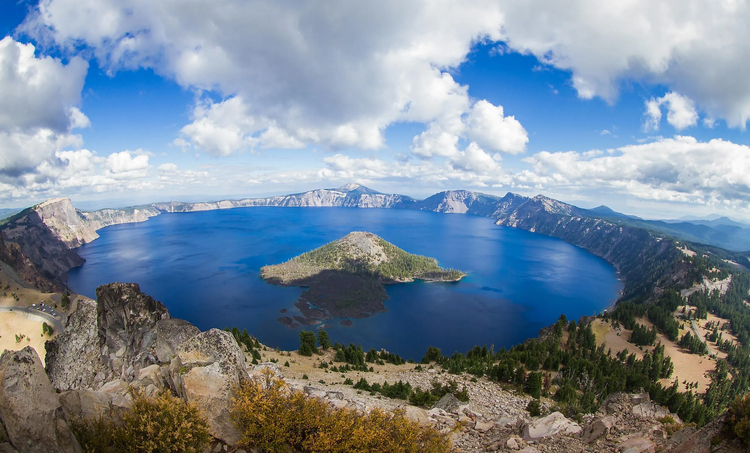
Crater Lake, Oregon

Here is the headline the lake's own admirers somehow keep forgetting: at about 1,943 feet, Crater Lake is the deepest in the United States, and one of the deepest on Earth. It sits in the collapsed shell of Mount Mazama, a volcano that blew its top roughly 7,700 years ago, and since no rivers feed or drain it, every drop is rain and snowmelt, which is why the blue is so absurdly pure. The lake lies about 60 miles north of Klamath Falls inside Crater Lake National Park. Wizard Island and the Garfield Peak Trail are the marquee attractions, and the rim is open year-round. One catch worth planning around: the Cleetwood Cove Trail, the only legal route down to the water and the only spot you can swim, is closed along with all boat tours for rehabilitation through 2028. Private boats have never been allowed. Camp at Mazama Village or the smaller Lost Creek Campground inside the park.
Lake Ouachita, Arkansas

Lake Ouachita (say it WAH-shih-tah) hides a forest. When the U.S. Army Corps of Engineers built Blakely Mountain Dam between 1948 and 1953, nobody cleared the valley first, so an entire stand of trees, some topping 60 feet, still stands upright beneath the surface, drawing scuba divers from around the world. At about 40,000 acres it is the largest lake entirely inside Arkansas; the slightly bigger Bull Shoals cheats by crossing into Missouri. It averages around 50 feet deep and plunges to roughly 200, sits in Garland and Montgomery counties near Hot Springs, and is wrapped completely in the Ouachita National Forest, so no houses break the shoreline. The name comes from the Choctaw "Owa Chito," meaning big hunt. Anglers chase bass, bream, catfish, and walleye, while paddlers follow the marked Geo-Float Trail past the area's geology. The water is clean enough to host freshwater jellyfish, which only show up in the purest lakes.
Lake Winnipesaukee, New Hampshire

Vacationers were coming to Lake Winnipesaukee before there was a United States to vacation in. The town of Wolfeboro on its shore bills itself as the oldest summer resort in America, a claim rooted in Governor John Wentworth's getaway here in the mid-1700s. The largest lake in New Hampshire and the third largest in New England, after Champlain and Maine's Moosehead, it sits in the foothills of the White Mountains and counts 365 islands, 274 of them habitable, including a quirky trio all named Loon Island. The list of things to do barely ends: fishing, swimming, kayaking, boating, hiking, camping. Climb to Castle in the Clouds, the mountaintop estate in Moultonborough, or work the boardwalk and arcades at Weirs Beach when you want the lake at its loudest.
Lake Pontchartrain, Louisiana

Calling Pontchartrain a lake is a generous simplification; it is really a brackish estuary, a tidal lagoon connected to the Gulf, which is part of what makes it feel oceanic. At about 630 square miles it is the largest body of water in Louisiana, touching six parishes, and it carries the name of Louis Phelypeaux, Comte de Pontchartrain. Crossing it is the main event: the Lake Pontchartrain Causeway runs 23.83 miles on 9,500 concrete pilings linking Metairie and Mandeville, and since 2011 it has held the Guinness record as the longest continuous bridge over water, edged out only on a technicality by a Chinese bridge that counts its overland stretches. Beyond the drive, the lake delivers fishing, boating, paddling, great seafood, and miles of bike and walking trails, plus the New Canal Lighthouse Museum, first lit in the 1850s and rebuilt after Hurricane Katrina in 2005.
Lake Chelan, Washington

Another sleeper superlative: at 1,486 feet, Lake Chelan is the third deepest lake in America, trailing only Crater Lake and Tahoe. Stretching 50.5 miles through the heart of Washington and averaging barely more than a mile wide, it is less a lake than a landlocked fjord, with peaks shooting straight up from the water. Its name is a Salish word for deep water, which tracks. Sitting in the Okanogan-Wenatchee National Forest, the lake runs from the roadless community of Stehekin in the northwest, reachable only by boat or floatplane, down to the towns of Chelan and Manson in the southeast. Drive in over the North Cascades Highway and you cross Washington Pass and Rainy Pass, two high points famous for dramatic scenery and serious avalanche danger, not skiing; the route shuts every winter for exactly that reason, so mind the season.
Flathead Lake, Montana

Flathead Lake earns its bragging rights honestly: at about 197 square miles it is the largest natural freshwater lake in the western United States outside Alaska, and one of the cleanest large lakes in the populated world. It is a leftover of Glacial Lake Missoula, the Ice Age giant whose dam-bursts carved the scablands two states over. Up in Montana's northwest near Glacier National Park, Flathead backs a wall of mountains with that wide Montana sky. Anglers pull lake trout, whitefish, and yellow perch from it, while the native bull trout and westslope cutthroat are catch-and-release. Three state parks anchor the shore: Big Arm and Lake Mary Ronan to the west, and Wild Horse Island, reachable only by boat, where bighorn sheep and a few actual wild horses roam the largest island in the lake.
Lake Allatoona, Georgia

Lake Allatoona is a drowned town. When the Army Corps dammed the Etowah River for flood control and filled the basin by 1950, the old mining community of Allatoona, founded in 1838 and fought over in an 1864 Civil War battle, went under for good. What rose in its place is one of the prettiest lakes in Georgia, just northwest of Atlanta near Cartersville, covering more than 12,000 acres with nearly 270 miles of shoreline. It pulls double duty as drinking water for Acworth, Woodstock, and parts of Atlanta. Beyond fishing, boating, and swimming, you can rent a lakeside cabin, hike the Cooper's Furnace trail past the ruins of an old iron furnace, or spread out across Red Top Mountain State Park and the cluster of county parks along the banks.
Lake Marion, South Carolina

South Carolina's largest lake is a war hero's flooded backyard. Lake Marion covers more than 110,000 acres, spans five counties, and earns its nickname, the state's inland sea. It was created in 1941 when the Santee Cooper project dammed the Santee River for Depression-era power and jobs, and it is named for Revolutionary War general Francis Marion, the "Swamp Fox," whose own plantation, Pond Bluff, vanished beneath the rising water. Because the land was never fully cleared, drowned cypress and standing stumps still break the surface, which is exactly why the fishing is so good. Near the town of Santee, with marinas and resorts close by, you can rent pontoons, houseboats, kayaks, and jet skis, and the cypress flats teem with hawks, eagles, egrets, osprey, deer, and the occasional alligator working the shallows.
Lake Tahoe, California/Nevada

If Crater Lake is the deepest, Lake Tahoe is the runner-up, dropping 1,645 feet, and it is the largest alpine lake in North America besides. Straddling Nevada and California high in the Sierra Nevada, it is probably the most famous lake in the country, and it backs the reputation with swimming, fishing, jet-skiing, paddling, and boating on water the color of glass. One correction worth making: there is no "Lake Tahoe National Park." The protected gems are state parks, Lake Tahoe Nevada State Park, home to the celebrated Sand Harbor, on the eastern shore, and Emerald Bay State Park on the California side, both stacked with trails, campsites, and tour outfitters. Incline Village, on the Nevada shore near Sand Harbor, makes a handsome base camp.
Lake Okeechobee, Florida

Forget the theme parks: Lake Okeechobee sits in south-central Florida, a good three hours south of Orlando, spread across the flatlands just north of the Everglades. It is the largest freshwater lake in Florida and, after Lake Michigan, the second largest entirely within the contiguous United States, covering some 730 square miles while averaging only about nine feet deep, which is why locals call it the inland sea you cannot see across. It formed roughly 6,000 years ago as the ocean pulled back, and its name means "big water" in the Hitchiti and Seminole tongue, from oki and chubi. The signature experience is the 110-mile Lake Okeechobee Scenic Trail, a hiking and cycling path running the top of the Herbert Hoover Dike. Anglers come for some of the best largemouth bass in the country, birders for the rim's astonishing flocks; just leave the swimming to the alligators. Kissimmee Prairie Preserve and the Okeechobee Battlefield round out the parks.
Lake Willoughby, Vermont

Lake Willoughby is the closest thing the East Coast has to a fjord. Glaciers gouged this deep, narrow trench in Vermont's Northeast Kingdom, and the cliffs of Mount Pisgah and Mount Hor rise so steeply from either shore that the lake has been called the Lucerne of America since the 1800s. Its southern end is wrapped in the Willoughby State Forest, near the small town of Westmore and just up the road from East Burke. Hike Sentinel Rock State Park for sunset views, or climb Mount Pisgah past Pulpit Rock, a long-standing nesting site for peregrine falcons. Keep your camera ready: bald eagles, moose, and black bears all turn up along the water.
Skaneateles Lake, New York

Skaneateles (skan-ee-AT-lus, from the Onondaga word for "long lake") is so clean that Syracuse drinks straight from it, piping the water to the city largely unfiltered, a rarity among American cities. The highest of the Finger Lakes by elevation, it has long carried the nickname "Roof Garden of the Lakes," and it is widely held to be the clearest of the bunch, give or take the occasional algae scare. It lies a few miles southwest of Syracuse, with the tidy village of Skaneateles at its northern tip and limited public shoreline precisely because the water is a drinking supply. The lake has hosted sailing regattas since 1847, so expect masts on the horizon alongside the kayakers and windsurfers, and views worth the trip at both sunrise and sunset.
Lake Geneva, Wisconsin

First, a name to get straight: the water is Geneva Lake, and the resort town on its north shore is Lake Geneva, a distinction locals will gently correct you on. Set in Walworth County in southeastern Wisconsin, this spring-fed lake became the Midwest's Gilded-Age playground, and its best feature is free: the roughly 21-mile Geneva Lake Shore Path, a public footpath that loops the entire shoreline past mansions and boathouses you could never otherwise see. Beyond the walk, the area stacks up zip-lining, mountain biking, hiking, and winter skiing, plus the Timber Ridge Lodge and Waterpark and the Walworth County Fairgrounds. Bed down outdoors at Big Foot Beach State Park, the Lake Geneva Youth Camp, or Elkhorn Campground.
Worth the Drive
What ties these fifteen together is not a single look but a single feeling: the small jolt of standing at the edge of water that dwarfs you. A flooded Oregon caldera, an Alaskan reservoir glowing glacial blue, a Louisiana estuary you cross on a 24-mile bridge, a Finger Lake clean enough to pipe to a city untreated. Beauty is what got each one onto the list. The facts are what make them stick. Pick one, point the car at it, and go see for yourself.


