The Largest Islands In The Contiguous United States
Long Island stretches across 1,401 square miles of southeastern New York, which makes it larger than the other nine islands on this list combined. It is the biggest island in the contiguous United States by a wide margin, and the ranking it heads runs the full range of what an American island can be. These ten sit along the Pacific and Atlantic coasts and inside the Great Lakes, and they include dense metropolitan counties, working wildlife refuges, and national parks without a single road. Ranked strictly by land area, here are the largest islands in the lower 48.
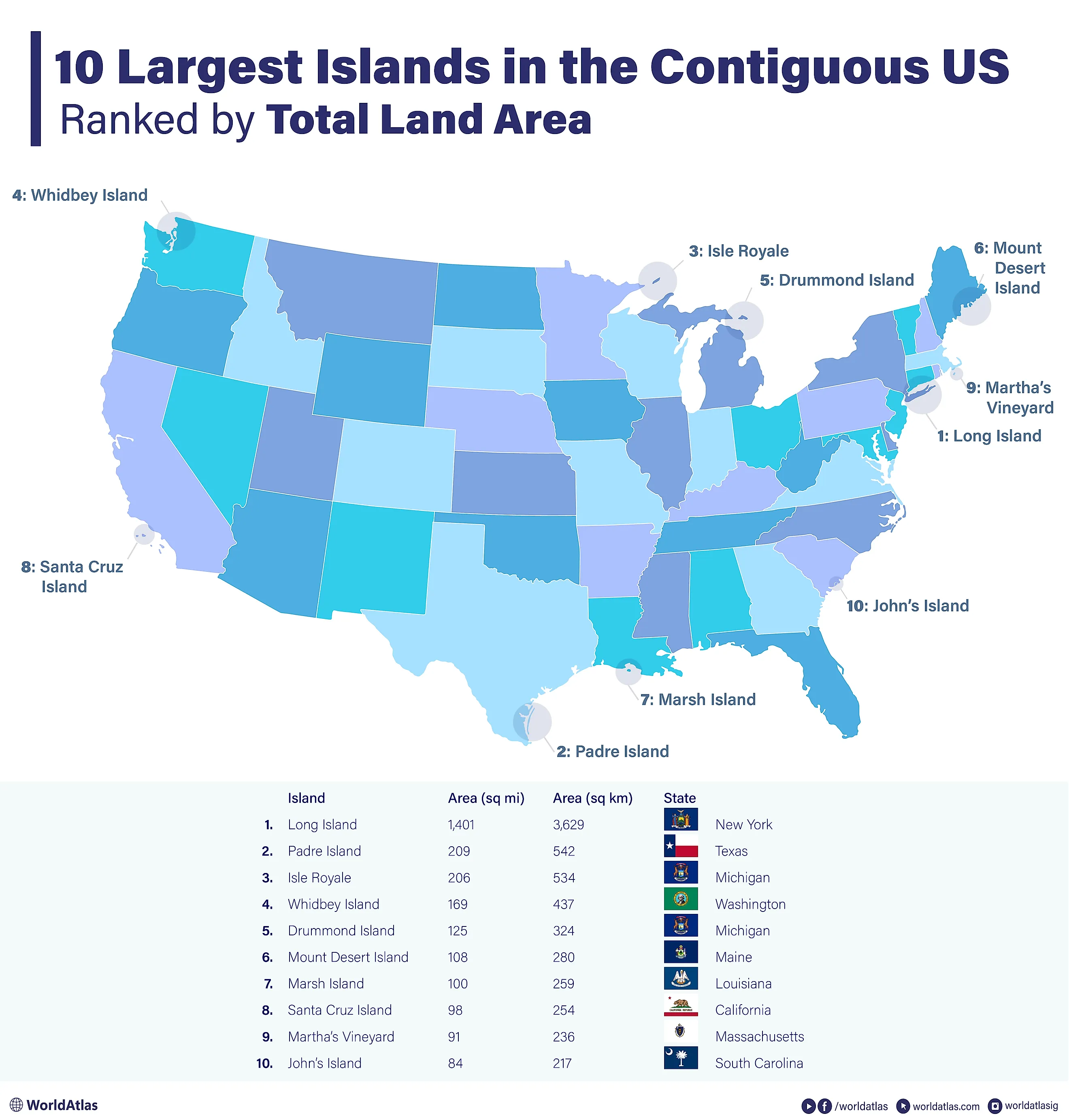
10 Largest Islands In The Contiguous US By Land Area
| Rank | Name of Island | Area (sq mi) | Area (sq km) | Location |
|---|---|---|---|---|
| 1 | Long Island | 1,401 | 3,629 | New York |
| 2 | Padre Island | 209 | 542 | Texas |
| 3 | Isle Royale | 206 | 534 | Michigan |
| 4 | Whidbey Island | 169 | 437 | Washington |
| 5 | Drummond Island | 125 | 324 | Michigan |
| 6 | Mount Desert Island | 108 | 280 | Maine |
| 7 | Marsh Island | 100 | 259 | Louisiana |
| 8 | Santa Cruz Island | 98 | 254 | California |
| 9 | Martha's Vineyard | 91 | 236 | Massachusetts |
| 10 | Johns Island | 84 | 217 | South Carolina |
Long Island, New York

Spanning 1,401 square miles, Long Island is by far the largest island in the contiguous United States. It is also the most populous, home to 8,063,232 residents per the 2020 census, which equals 40% of the state's total population. If Long Island were a US state, it would rank 13th in population.
Situated in southeastern New York, the East River separates Long Island from the rest of the state, while Long Island Sound divides it from Connecticut. The island is made up of four counties: Kings (Brooklyn), Queens, Nassau, and Suffolk. Manhattan and the Bronx lie across the East River to the west. Long Island also holds two major airports, including John F. Kennedy International, one of the nation's busiest.
Padre Island, Texas

Lying along the Texas coast, Padre Island covers 209 square miles, making it the second largest island in the contiguous United States. A barrier island, it runs 113 miles down the coast as the longest barrier island in the world, beginning near Corpus Christi and ending at Port Isabel, just short of the Mexican border. A little over 2,800 people reside on the island, the majority in the north.
Laguna Madre, a shallow lagoon, separates Padre Island from mainland Texas, while the Port Mansfield Channel divides its southern end from neighboring South Padre Island. A large portion of the island was designated a national seashore in 1962, and Padre Island National Seashore now protects the longest stretch of undeveloped barrier island in the world. The national seashore runs an active program dedicated to sea turtle nesting, egg incubation, and the release of hatchlings.
Isle Royale, Michigan

Isle Royale, located in Lake Superior in northwest Michigan, is the third largest island in the contiguous United States at 206 square miles. It sits closer to the Canadian province of Ontario, about 15 miles away, than to the Michigan coast, roughly 56 miles off. Mount Desor, at 1,394 feet, is the island's highest point.
Part of Isle Royale National Park, the island has no permanent residents. The park is the least-visited in the contiguous US, drawing about 29,000 visitors in 2023. Designated a wilderness area in 1976, Isle Royale has no roads.
Whidbey Island, Washington

Situated in northwest Washington in Puget Sound, Whidbey Island covers 169 square miles, making it the fourth largest island in the contiguous US. An estimated 60,000 to 70,000 residents live there, and its main towns are Oak Harbor, Coupeville, and Langley.
Built in 1935, the Deception Pass Bridge connects Whidbey Island to neighboring Fidalgo Island, with ferries providing additional access. The National Park Service designated part of the island as Ebey's Landing National Historical Reserve, the first national historical reserve in the country, to preserve its rural landscape and rare native plants. The island is also home to six state parks.
Drummond Island, Michigan

Drummond Island, in northern Michigan in Lake Huron, is the fifth largest island in the contiguous United States at 125 square miles. It is also the country's second-largest freshwater island, after Isle Royale. About 1,000 residents live on Drummond Island, which is connected to the mainland by a ferry that runs every day of the year.
The island holds 13 distinct ecosystems, including six kinds of forest, five kinds of swamp and marsh, cobble beaches, and inland lakes and rivers. Cliffs along its eastern side are part of the Niagara Escarpment. The only highway on Drummond Island is M-134.
Mount Desert Island, Maine

Located along Maine's Atlantic coast, Mount Desert Island spans 108 square miles, making it the sixth largest island in the contiguous US. It lies within Frenchman Bay, and Somes Sound, a roughly 5-mile fjord, nearly cuts the island in two. In 1919, Acadia National Park, the first national park east of the Mississippi River, was established here.
Mount Desert Island has a year-round population of about 10,000, a number that swells each summer as visitors flock to Acadia National Park, which draws nearly 4 million visits a year. Cadillac Mountain, at 1,530 feet, is the tallest of the island's peaks and ranks among the highest points on the US Atlantic coast.
Marsh Island, Louisiana

Marsh Island lies off the coast of southern Louisiana and is the seventh largest island in the contiguous US at 100 square miles. It sits between the Gulf of Mexico and Vermilion Bay, and most of its land is low and marshy. No one lives on the island.
Storms and erosion have steadily eaten away at Marsh Island over the past century, shrinking its low-lying land. The island is an important wildlife refuge, protecting waterfowl, shorebirds, birds of prey, fish, furbearers, and alligators, and people visit to shrimp, fish, and crab in its waters.
Santa Cruz Island, California

Santa Cruz Island lies off the southern coast of California, near the town of Ventura, and spans 98 square miles. Part of Santa Barbara County, it recorded a population of just 2 people in the 2000 census. The National Park Service owns 24% of the island, and the Nature Conservancy owns the other 76%.
The island has a varied geography, with two mountain ranges, a central valley, 77 miles of coastal cliffs, canyons fed by springs and streams, beaches, sea caves, and tidepools. More than 150 animal species live there. The island scrub-jay and eight plant species exist nowhere else on Earth, having evolved in isolation over millions of years.
Martha's Vineyard, Massachusetts

Located on the Atlantic coast in southeastern Massachusetts, Martha's Vineyard covers 91 square miles. Vineyard Sound separates it from Cape Cod, which lies just 4 miles to the north. The island has more than 20,000 year-round residents, a number that surges into the range of 90,000 to 200,000 in summer.
Thanks to its resort towns, the economy of Martha's Vineyard leans heavily on tourism and summer yachting. Its coastline is dotted with ponds and inlets sealed off by sand spits, and the highest point on the island is Peaked Hill, at 311 feet above sea level.
Johns Island, South Carolina

Lying along the southern coast of South Carolina, Johns Island is the tenth largest island in the contiguous US at 84 square miles. The Stono River separates it from the mainland to the northeast, and the Wadmalaw River borders it to the northwest. Its population has climbed quickly over the past decade as Charleston has spread toward it, making Johns Island one of the faster-growing parts of the Charleston area.
The island is fairly flat and marshy, cut through by many rivers. Alongside hundreds of bird species, it is home to alligators, bobcats, coyotes, otters, deer, and wild hogs, plus shellfish and dolphins in its marshes and rivers. Angel Oak, a live oak estimated at 300 to 400 years old, is a popular attraction, drawing hundreds of thousands of visitors a year.
The Evolving Landscapes of America's Largest Islands
For all that they share in size, these ten islands have almost nothing else in common. Some hold millions of people and major airports; others have no residents and no paved roads. Their populations move in opposite directions, too. Johns Island is filling up as Charleston spreads toward it, while low-lying Marsh Island keeps losing ground to storms and erosion. Land area is the one thing that places them all on the same list.