10 Largest Islands In The World
- Greenland is the world’s largest island.
- Three of the world’s 10 largest islands are located in northern Canada.
- New Guinea is a transcontinental island as it transcends both Asia and Oceania.
- Honshu, Japan’s main island, is the second most populated island in the world.
- Great Britain is the largest island in Europe.
There are so many islands around the world that no one knows exactly how many there are. There are also many different types of islands. Indeed, islands come in many shapes and sizes. There are islands that are so small that they do not even have names. There are also islands that are so large, you could fit several countries in them. In fact, some large islands do contain two or more countries. Here are the world’s 10 largest islands by land area.
1. Greenland
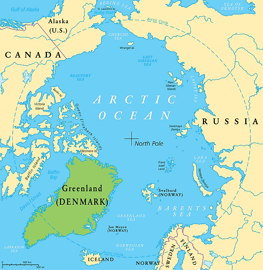
Greenland is the world’s largest island. The total land area of Greenland is 2.16 million sq. km, though this figure also includes some small, offshore islands. The island is situated in the far north, to the east of Baffin Bay, across which is northern Canada. Greenland traverses the North Atlantic Ocean and Arctic Oceans. Most of the island is covered by a vast sheet of ice, which measures 1.8 million sq. km. Greenland has a population of about 57,000, most of whom are Inuit. The island is under Danish sovereignty, though it does have autonomy to govern its own internal affairs.
2. New Guinea
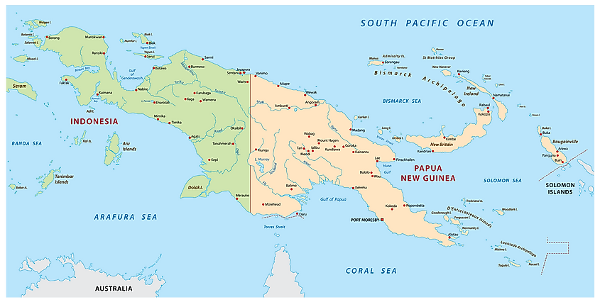
New Guinea is the world’s second largest island, measuring at 785,753 sq. km. It is situated in the Pacific Ocean, to the north of Australia and the Coral Sea, to the west of the Solomon Islands, to the east of the Banda Sea, and to the south of the Philippine Sea. The island traverses two continents, Asia and Oceania. The border between Asia and Oceania is generally considered to be the border between Papua New Guinea and Indonesia. Papua New Guinea, on the eastern side of the island, is considered part of Oceania, while the western, Indonesian part is considered part of Asia. New Guinea is very multilingual. In fact, Papua New Guinea alone is the most linguistically diverse country in the world, with more than 700 languages spoken therein.
3. Borneo
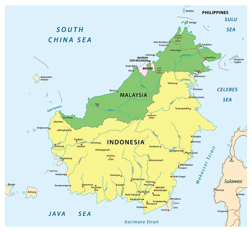
Borneo is a large island in Southeast Asia. Three countries, Indonesia, Malaysia, and Brunei share the island. Indonesia controls 73% of Borneo’s territory, while Malaysia controls 24%, in the north of the island, including most of the island’s northern coast, which faces the South China Sea. The remaining 1% of Borneo is controlled by the small sultanate of Brunei, which is also situated on the island’s northern coast. Borneo has a total land area of 743,330 sq. km. The indigenous people of the island are known as the Dayaks. They are divided into 50 ethnic groups and have 140 different languages and dialects.
4. Madagascar
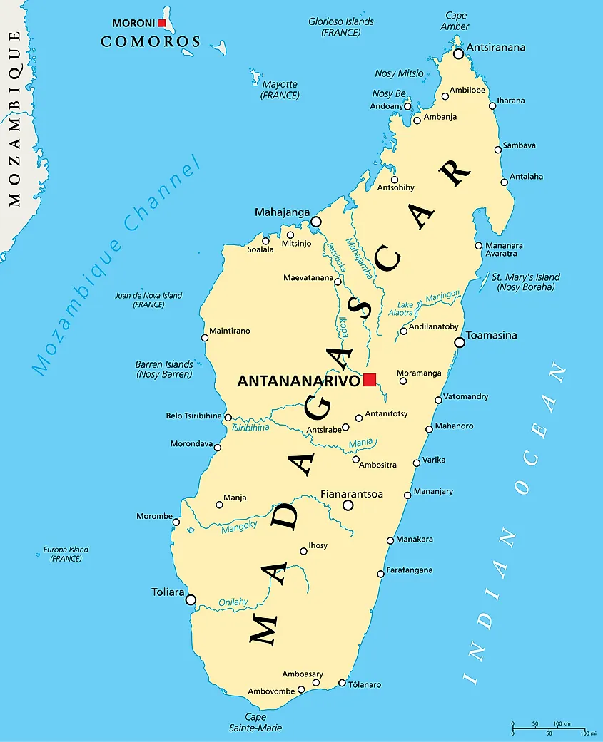
Madagascar, which is also the name of the country situated on it, is an East African island in the Indian Ocean. Its western coast faces the Mozambique Channel, across which is the African mainland. Madagascar has a total land area of 587,713 sq. km, making it the largest island in Africa and the largest in the Indian Ocean. The island has a population of approximately 28 million. Madagascar contains 0.5% of all known plant and animal species in the world.
5. Baffin Island
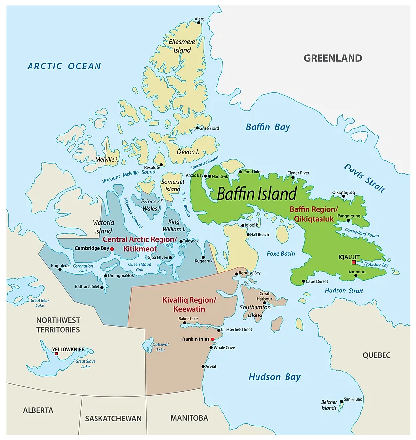
Baffin Island is located in northern Canada. It is part of the Canadian territory of Nunavut, whose capital, Iqaluit, is based on the southern end of the island. Iqaluit is home to about half of Baffin Island’s total estimated population of 11,000. The total land area of Baffin Island is 507,451 sq. km, making it the largest island in Canada. The island’s wildlife includes snowy owls, narwhal, polar bears, and beluga whales. Baffin Island also features spectacular views of the Northern Lights.
6. Sumatra
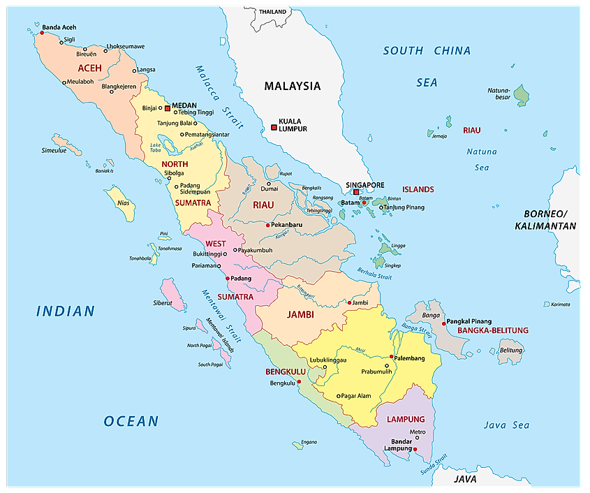
Sumatra is the westernmost of the large islands of Indonesia. To its north is the Andaman Sea, and to its south and west is the Indian Ocean. To the east of the northern end of Sumatra is the Malacca Strait, across from which is Malaysia. The island of Borneo also lies to the east, as does the Java Sea. The southeast of Sumatra borders the narrow Sunda Strait, across from which is the island of Java. The total land area of Sumatra is 443,066 sq. km. About 40 million people live on the island, which is also home to an abundance of wildlife, including monkeys, Sumatran tigers, rhinoceroses, and elephants.
7. Honshu
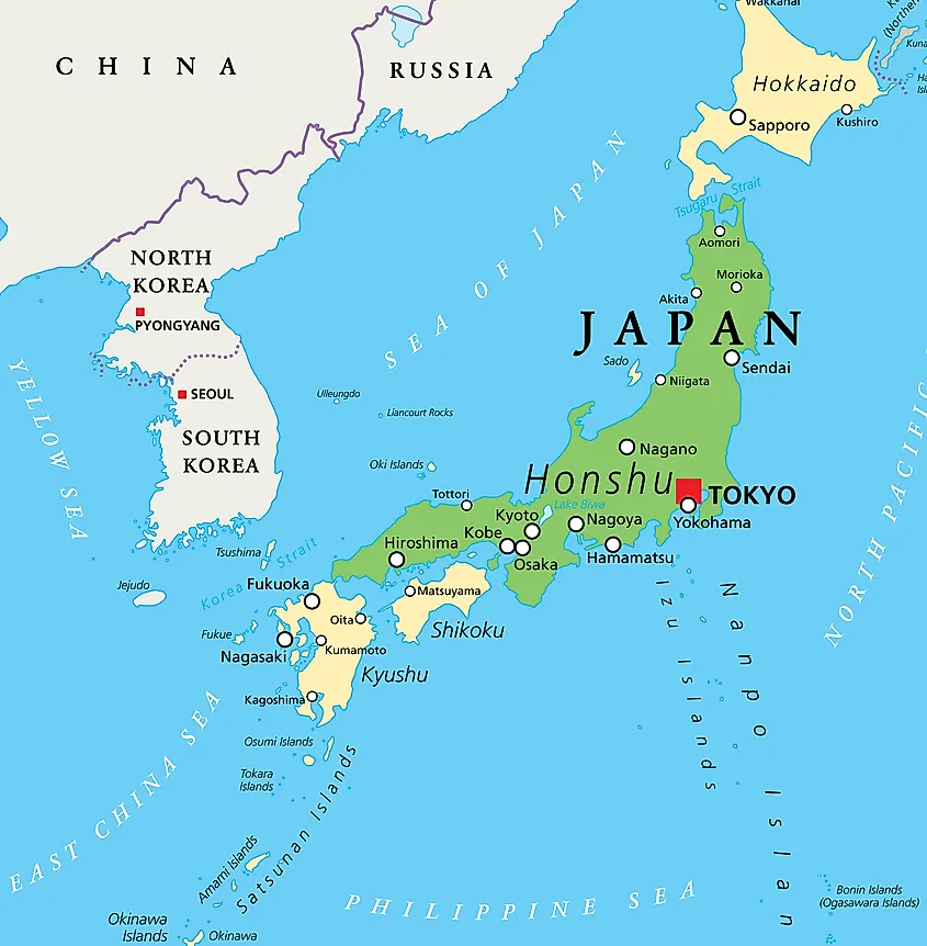
Honshu is the largest island in the archipelago and country known as Japan. It has a total land area of 225,800 sq. km, and an estimated population of 103 million, which means that it is home to the majority of Japan’s total population. Tokyo, the world’s most populous city and capital of Japan, is situated on the southern end of Honshu. In addition, all of Japan’s highest mountain peaks, including Mt. Fuji, are on Honshu, as is the country’s largest lake, Lake Biwa.
8. Victoria Island
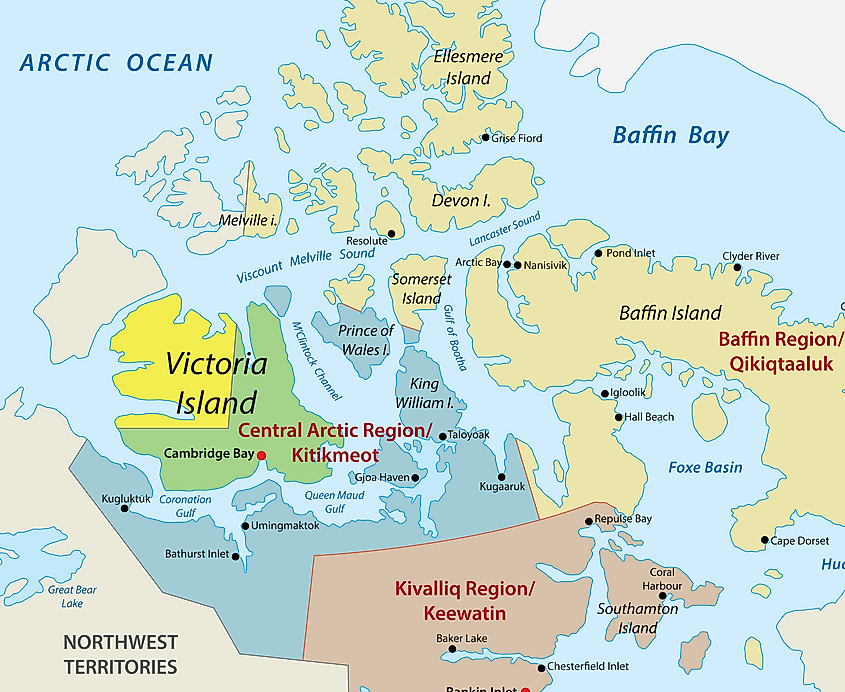
Victoria Island is another northern Canadian island. The island is split between the Canadian territories of Nunavut and the Northwest Territories. Mainland Nunavut lies to Victoria Island’s south. The island is bigger than 36 of the 50 U.S. states. Its total land area is 217,291 sq. km. Despite its size, however, just under 2,000 people live on the island. In fact there are many more caribou and musk-ox on the island than there are people.
9. Great Britain
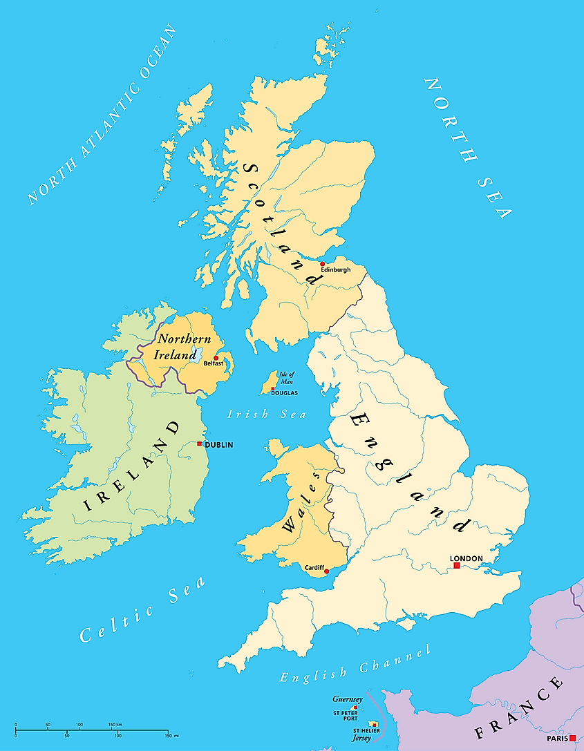
Great Britain is Europe’s largest island, and of course, the main territory of the United Kingdom. Its total land area is 209,331 sq. km. Although it is common for people to refer to Great Britain simply as England, England is just one of three countries on the island. Scotland and Wales are the other two. Out of a total population of about 67 million people, approximately 64 million of the U.K.’s people live on the island of Great Britain. On the west coast of Great Britain is the Irish Sea, across from which lies the island of Ireland. The North Sea lies to the east. An undersea tunnel, called the Channel Tunnel, or “Chunnel”, links Great Britain to France, across the English Channel to the south.
10. Ellesmere Island
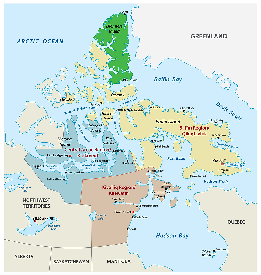
Ellesmere Island is the northernmost island in Canada. Its total land area is 183,965 sq. km. Like Victoria Island, Ellesmere Island lies entirely in the Arctic Circle. Just 146 people live on the island. Most of the island consists of a mountain range called the Arctic Cordillera. This feature makes Ellesmere Island the most mountainous island in the entire Canadian Arctic archipelago.
10 Largest Islands In The World
| Rank | Island | Area (sq. Km) |
|---|---|---|
| 1 | Greenland | 2,166,086 |
| 2 | New Guinea | 785,753 |
| 3 | Borneo | 743,330 |
| 4 | Madagascar | 587,713 |
| 5 | Baffin Island | 507,451 |
| 6 | Sumatra | 443,066 |
| 7 | Honshu | 225,800 |
| 8 | Victoria Island | 217,291 |
| 9 | Great Britain | 209,331 |
| 10 | Ellesmere Island | 183,965 |
