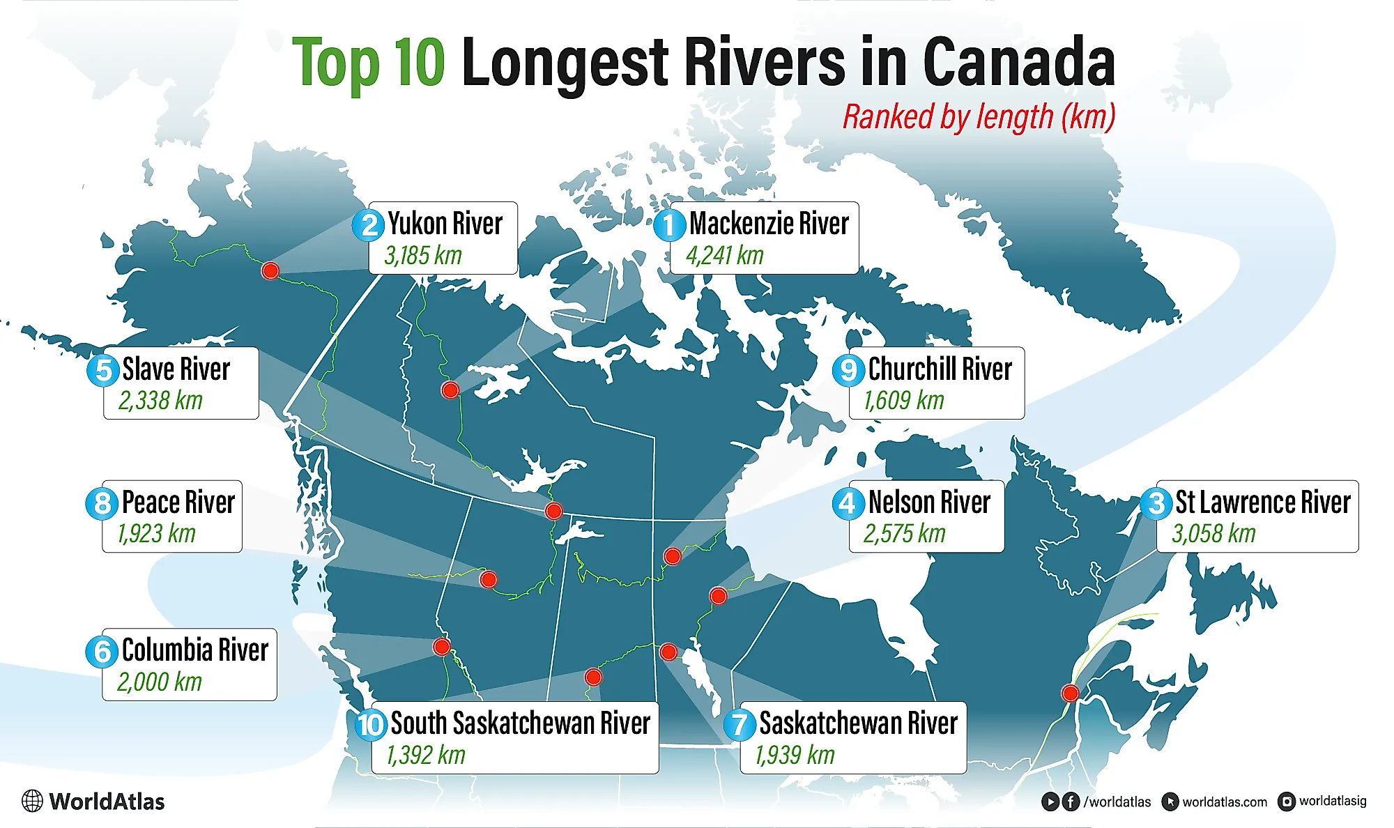
10 Longest Rivers In Canada
Canada has over 40 rivers that are longer than 600 km (373 mi), and many of these are thousands of kilometers long. The longest river in Canada is the Mackenzie River, which stretches 4,241 km (2,635 mi) through the country’s Northwest Territories. Apart from the Mackenzie River, other major long rivers in Canada include the Yukon River, Saint Lawrence River, Nelson River, and Slave River.
Many of Canada’s longest rivers flow entirely within the country, while others extend across international borders into the United States. This list ranks the top ten longest rivers in Canada based on total length, including portions that flow outside the country.
10 Longest Rivers In Canada
| Rank | River Name | Total Length km (mi) |
|---|---|---|
| 1 | Mackenzie River | 4,241 (2,635) |
| 2 | Yukon River | 3,185 (1,979) — extends into the United States |
| 3 | Saint Lawrence River |
3,058 (1,900) — extends into the United States
|
| 4 | Nelson River | 2,575 (1,600) |
| 5 | Slave River | 2,338 (1,453) |
| 6 | Columbia River |
2,000 (1,243) — extends into the United States
|
| 7 | Saskatchewan River | 1,939 (1,205) |
| 8 | Peace River | 1,923 (1,195) |
| 9 | Churchill River | 1,609 (1,000) |
| 10 | South Saskatchewan River | 1,392 (865) |
1. Mackenzie River - 4,241 km (2,635 mi)

The Mackenzie River is the longest river in Canada, spanning 4,241 km (2,635 mi) across the Northwest Territories. The river is located entirely within Canada and begins at its source, Great Slave Lake, one of the largest lakes in the country. From there, it flows northwest through vast boreal forests and tundra, forming the second-largest drainage basin in North America, covering an estimated 1.8 million km2 (694,984 mi2). The river continues past the Mackenzie Mountains before reaching its mouth at the Arctic Ocean, within the Inuvik Region of the Northwest Territories.
Throughout its course, the Mackenzie River displays significant variation in width, narrowing to about 500 m (1,600 ft) in some sections and expanding to nearly 7,000 m (23,000 ft) at its widest points. Near its endpoint, the river forms the expansive Mackenzie Delta, where the mean annual discharge is approximately 9,630 m3/s (340,000 ft3/s), increasing to about 15,290 m3/s (540,000 ft3/s) during summer melt. The Mackenzie River supports extensive wetlands and wildlife habitat, including migratory birds, muskrats, and Arctic fish species, and has long served as a transportation and trade route for Indigenous communities in northern Canada.
2. Yukon River - 3,185 km (1,979 mi)

The Yukon River is the second-longest river in Canada and one of the most prominent river systems in northwestern North America. It originates in the Coast Mountains of northern British Columbia, then flows northwest through the Yukon Territory, crosses into Alaska, and eventually empties into the Bering Sea. In total, the river stretches approximately 3,185 km (1,979 mi), with roughly 1,200 km (746 mi) of its length flowing through Canada.
The Yukon River drains a vast watershed covering approximately 855,000 km2 (330,000 mi2) and encompasses boreal forests, alpine valleys, wetlands, and tundra landscapes. For thousands of years, the river has served as a vital transportation corridor and subsistence resource for Indigenous peoples, supporting fishing, seasonal travel, and settlement along its banks. During the Klondike Gold Rush of the late 19th century, the Yukon River became a critical route for prospectors and supply vessels traveling toward the Yukon’s goldfields.
3. Saint Lawrence River - 3,058 km (1,900 mi)

The Saint Lawrence River is another major river system that spans both Canada and the United States, beginning its course at Lake Ontario in Ontario. From there, it flows northeast through Ontario and Quebec, forming part of the international boundary with New York State before widening into the Saint Lawrence River Estuary, which stretches for roughly 655 km (407 mi) from Quebec City to the Gulf of Saint Lawrence. Throughout this length, the river changes “form” several times as it passes through lakes and smaller bodies of water, including Lake Erie, Lake Superior, the Detroit River, and Lake Huron. Its total length of approximately 3,058 km (1,900 mi) reflects the full Saint Lawrence River system, including the Great Lakes drainage network. This makes it the third-longest river in Canada.
Along with having one of the largest estuaries in the world, the Saint Lawrence River has the second-highest discharge of any North American river. The discharge is fastest at Quebec City, where it can reach 22,766 m3/s (804,000 ft3/s). Thanks to its location along major cities like Montreal and Quebec City, the Saint Lawrence River has been vital to the region's development, providing a route for trade and marine traffic. Moreover, the river is a hub for marine life, connecting the Great Lakes to the North Atlantic. Blue whales, orcas, and sperm whales are just a few species found in the Saint Lawrence Estuary and Gulf.
4. Nelson River - 2,575 km (1,600 mi)

The Nelson River is located in the province of Manitoba and has a full length of 2,575 km (1,600 mi). This length reflects the Nelson River system, which carries water eastward from the Bow and Saskatchewan Rivers across the Canadian Prairies into Lake Winnipeg, where it officially becomes the Nelson River before continuing toward Hudson Bay. The river flows out of Lake Winnipeg through two main channels, both running northeast across northern Manitoba.
Along its route, the Nelson River passes through several large lakes, including Playgreen Lake and Split Lake, before reaching its mouth along the western shore of Hudson Bay. Much of the surrounding landscape is dominated by boreal forest and wetlands, gradually transitioning into low-lying coastal plains near the river’s endpoint. While most of the Nelson River’s course is sparsely populated, it plays a major role in hydroelectric power generation. A series of dams and generating stations built throughout the 20th century give the river an installed capacity of over 4,000 MW, making it one of Canada’s most important rivers for renewable energy production.
5. Slave River - 2,338 km (1,453 mi)

The Slave River flows northward from the border of Alberta into the Northwest Territories and acts as the main outflow of Lake Athabasca, one of the largest freshwater lakes in western Canada. From its source, the river travels roughly 434 km (270 mi) before emptying into Great Slave Lake. However, its full length of 2,338 km (1,453 mi) includes major upstream tributaries such as the Peace and Athabasca Rivers.
The river drops sharply in elevation along its course, creating one of the most powerful stretches of whitewater in northern Canada. The Slave River Rapids, located near Fort Smith, mark a dramatic transition between the Alberta plains and the Canadian Shield, with elevation dropping more than 40 m (130 ft) over a short distance. Average discharge along the Slave River exceeds 3,000 m3/s (105,944 ft3/s), making it one of the highest-volume rivers in the country. Because of its steep gradient, the river is not fully navigable. Still, it delivers large volumes of water and sediment into Great Slave Lake, supporting extensive delta wetlands and boreal wildlife corridors.
6. Columbia River - 2,000 km (1,243 mi)

The Columbia River is Canada’s sixth-longest river, and its route stretches through British Columbia and multiple states in the United States. The river’s route begins in British Columbia’s Rocky Mountains from Columbia Lake at 820 m (2,690 ft) above sea level. From its source, the river flows northwest through the Rocky Mountain Trench, then turns south near Revelstoke, crosses into the United States, and continues through Washington State. It later forms part of the border between Washington and Oregon, then cuts through the Cascade Range and empties into the Pacific Ocean near Astoria, Oregon.
Throughout its route, the Columbia River has a length of 2,000 km (1,243 mi), making it one of the largest rivers in North America. The Columbia River has an average discharge of about 7,500 m3/s (264,680 ft3/s), making it one of the highest-flowing rivers on the Pacific coast. Major tributaries include the Snake River, Kootenay River, and Willamette River, which together drain a large portion of the northwestern United States and southern British Columbia. The river supports large salmon runs, including Chinook, coho, and sockeye salmon, and has historically been one of the most important salmon-producing rivers in North America.
7. Saskatchewan River - 1,939 km (1,205 mi)

The Saskatchewan River is a major river system in central Canada with a total length of 1,939 km (1,205 mi), making it the seventh-longest in the country. The confluence of the North Saskatchewan and South Saskatchewan Rivers near Prince Albert, Saskatchewan, forms it. From this point, the river flows east across Saskatchewan and Manitoba before emptying into Lake Winnipeg. From the lake, its waters eventually continue toward Hudson Bay through the Nelson River system.
The Saskatchewan River drains a large basin covering approximately 336,000 km2 (129,730 mi2), much of it across the Canadian Prairies. Its flow is heavily influenced by snowmelt from the Rocky Mountains, primarily through the North Saskatchewan River, which originates at the Saskatchewan Glacier in Alberta. Average discharge near The Pas, Manitoba, is about 634 m3/s (22,389 ft3/s), though this varies widely by season. The river has been dammed at several points, including E.B. Campbell Dam, creating reservoirs used for hydroelectric power and water management.
8. Peace River - 1,923 km (1,195 mi)

Located in western Canada and also originating from the Rocky Mountains of British Columbia is the Peace River. This river begins its journey at the Finlay River in the northern part of the province and flows east through provincial parks such as Butler Ridge and Beatton River into Alberta. From the border, it flows northeast through the province, joining the Athabasca River to form the Slave River, which in turn joins the Mackenzie River. Thus, the combined Finlay-Peace-Slave-Mackenzie river system is considered to be one of the largest river systems in the world, as mentioned in the first entry. The Peace River itself covers a distance of 1,923 km (1,195 mi) in Canada and is the country’s eighth-longest river.
While it is slower than many other rivers in the country, with an average discharge of 2,110 m3/s (75,000 ft3/s) at Peace Point in Alberta, the Peace River is vital for western Canada’s wilderness. With over a dozen provincial parks along its routes and many smaller streams, wildlife is abundant. Animals such as golden and bald eagles, bears, and moose use the river and its surroundings as habitats. It is also a vital river for hydroelectricity, with multiple dams, including the W. A. C. Bennett Dam, which has a generating capacity of 2,730 MW and supplies around 30% of British Columbia's power requirements.
9. Churchill River - 1,609 km (1,000 mi)

The Churchill River flows across northern Saskatchewan and Manitoba and stretches for about 1,609 km (1,000 mi) from its headwaters to Hudson Bay. Unlike many rivers on this list, the Churchill does not follow a single, continuous channel for most of its length. Instead, it moves through a long chain of lakes, narrow straits, and short river sections shaped by ancient glacial activity. In Saskatchewan alone, the river passes through dozens of lakes, making its route wide, fragmented, and difficult to navigate in parts.
The river ultimately reaches Hudson Bay at the town of Churchill, Manitoba, one of Canada’s most well-known northern ports. Average discharge is roughly 1,200 m3/s (42,000 ft3/s), though seasonal variation is significant. The Churchill River basin covers about 280,000 km2 (108,108 mi2), much of it remote boreal forest and Canadian Shield terrain. Rapids and waterfalls are common, especially in the upper reaches, limiting large-scale navigation but creating strong hydroelectric potential. Several generating stations operate along the river, and the surrounding watershed supports caribou, wolves, waterfowl, and cold-water fish species typical of northern Canada.
10. South Saskatchewan River - 1,392 km (865 mi)

The tenth-longest river in Canada is the South Saskatchewan River, a tributary of the Saskatchewan River mentioned above. This river has a total length of 1,392 km (865 mi), stretching from the Oldman and Bow Rivers near Grassy Lake in Alberta to the Saskatchewan River east of Prince Albert. Throughout its course, the river flows northeastward through southern Alberta into Saskatchewan. In Saskatchewan, it is joined by the Red Deer River before opening up at Lake Diefenbaker and finally joining the North Saskatchewan River. The river system ultimately continues to flow eastward until discharging to Hudson Bay.
Flow along the South Saskatchewan River is highly regulated, with a mean discharge of about 280 m3/s (9,888 ft3/s), controlled by dams and reservoirs such as Lake Diefenbaker. The river is critical for irrigation and water supply across southern Alberta and Saskatchewan, flowing through one of Canada’s most productive agricultural regions. Moreover, it holds historical significance for Indigenous people, who have inhabited the basin for over 10,000 years due to its fishing and hunting opportunities.
The Longest Rivers In Canada
These ten rivers are the longest in Canada, either wholly or partly, in the country. From the Mackenzie River, one of the continent's largest at 4,241 km (2,635 mi), to the South Saskatchewan, a part of a larger river system, these are large bodies of water. They provide habitats for millions of animals, nourishment for flora, hydroelectricity for cities, and much more. Moreover, many of these rivers are interconnected, linking large bodies of water like the Great Lakes to the ocean.


