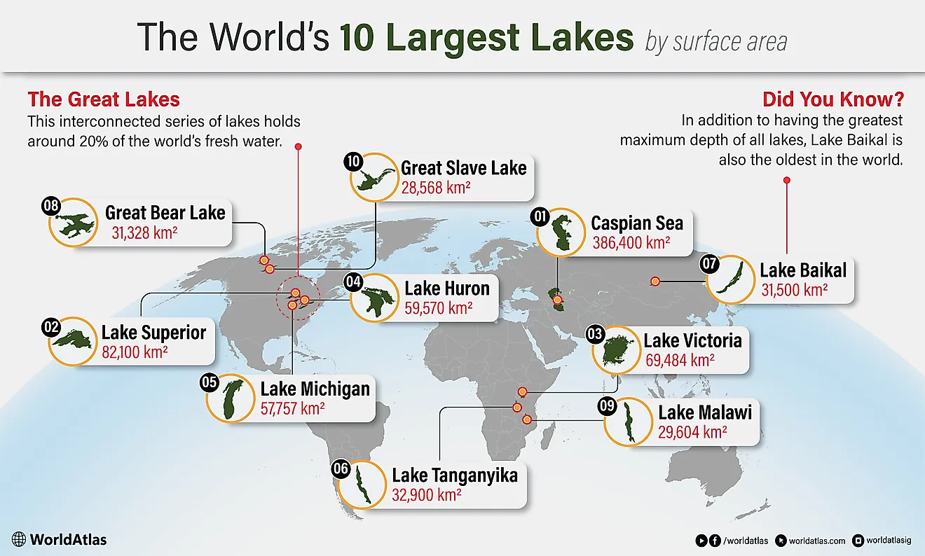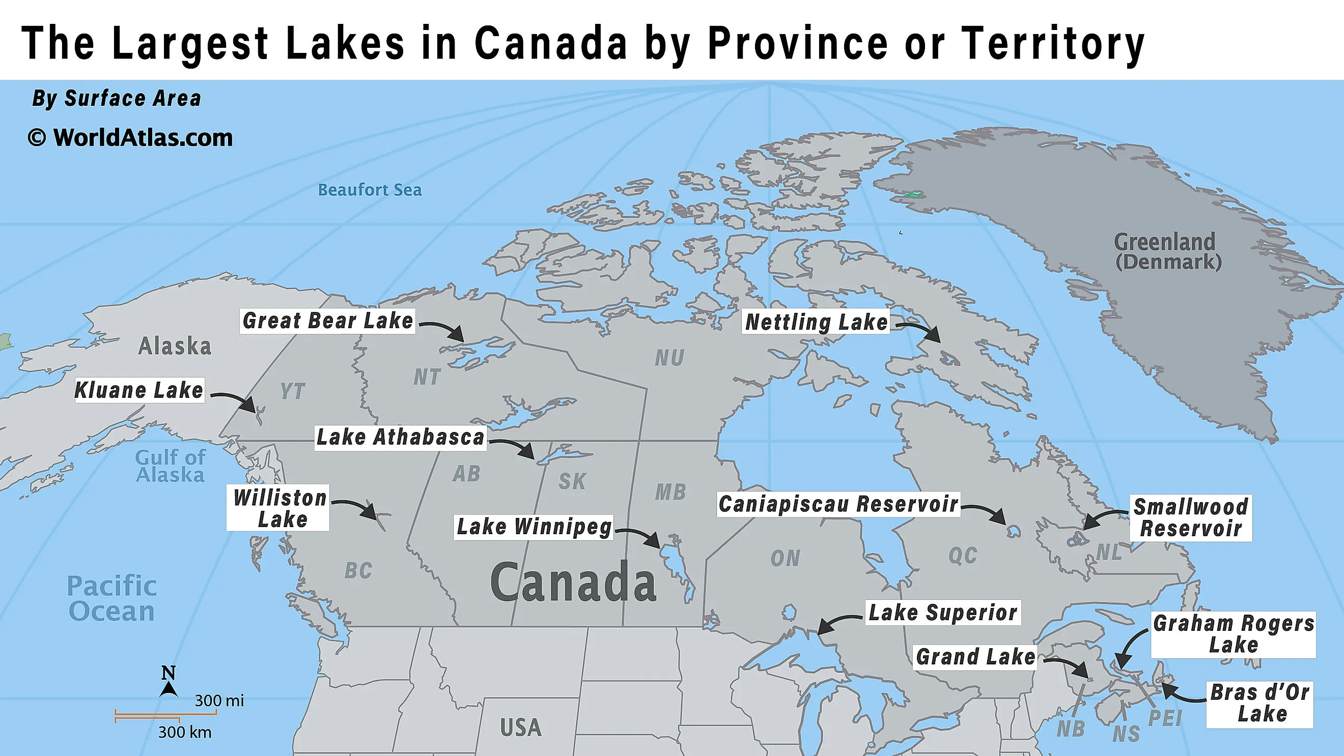
The Largest Lakes in Canada by Province or Territory
Across provinces and territories, the largest lakes in Canada range from a Great Lakes inland sea to vast northern basins and hydroelectric reservoirs. The quick answer for "largest lakes in Canada by province or territory" begins with Ontario's Lake Superior at 82,100 km2 (31,700 mi2) followed by Great Bear Lake in the Northwest Territories at 31,328 km2 (12,100 mi2) and Manitoba's Lake Winnipeg at 24,514 km2 (9,465 mi2). Nunavut's Nettilling Lake covers 5,542 km2 (2,140 mi2) on Baffin Island, and PEI's Graham Rogers Lake is 1.87 km2 (0.72 mi2)
Size also tracks how water moves. Lake Winnipeg's watershed sprawls across four provinces and parts of the U.S., concentrating nutrients and increasing pressure from algal blooms and zebra mussels. Elsewhere, the "largest lake" title belongs to reservoirs, Smallwood in Labrador, Caniapiscau in Quebec, and Williston in British Columbia, where dikes and dams redraw shorelines and regulate flow.
The variety is striking: Nova Scotia's Bras d'Or is tidal and brackish, Yukon's Kluane has seen inflow rerouted by glacial change, and Lake Athabasca spans Alberta and Saskatchewan on a route to the Arctic Ocean.
The Largest Lakes in Canada by Province or Territory
| Province or Territory | Largest Lake |
|---|---|
| Ontario | Lake Superior |
| Northwest Territories | Great Bear Lake |
| Manitoba | Lake Winnipeg |
| Alberta and Saskatchewan | Lake Athabasca |
| Newfoundland and Labrador | Smallwood Reservoir |
| Nunavut | Nettilling Lake |
| Quebec | Caniapiscau Reservoir |
| British Columbia | Williston Lake |
| Nova Scotia | Bras d'Or Lake |
| Yukon | Kluane Lake |
| New Brunswick | Grand Lake |
| Prince Edward Island | Graham Rogers Lake |
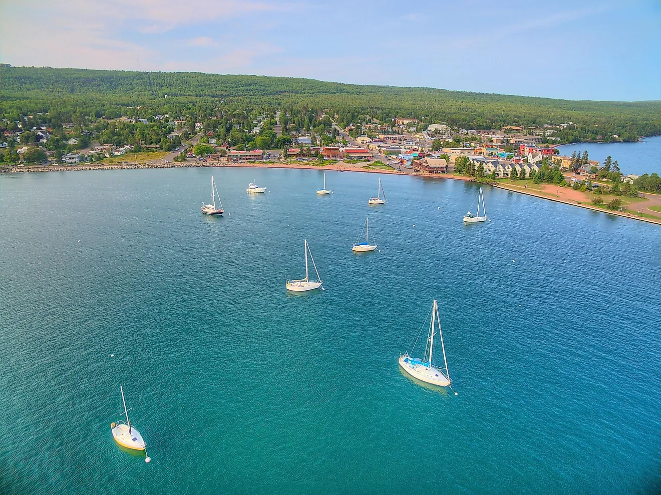
1. Ontario: Lake Superior - 82,100 km2 (31,700 mi2)

Lake Superior is Ontario's largest lake and the biggest of the Great Lakes, stretching along the province's north and east shores while also bordering Minnesota, Michigan, and Wisconsin. A glacial lake, it covers about 82,100 km2, making it the world's largest freshwater lake by surface area, and reaches depths of roughly 406 m. Major rivers such as the Nipigon, Pic, and Michipicoten feed Superior, and it drains through the St. Marys River to Lake Huron and onward to the Atlantic via the St. Lawrence system. The Ojibwe call it Gichi-gami, "great sea." Thunder Bay is the principal Ontario city on its vast, island-dotted shoreline. Isle Royale and the Slate Islands dot the water, and coastlines draw hikers to Lake Superior Provincial Park.
2. Northwest Territories: Great Bear Lake - 31,328 km2 (12,100 mi2)

Great Bear Lake is the Northwest Territories' largest lake and Canada's largest lake entirely within the country. A vast glacial basin on the Arctic Circle, it lies about 156 m above sea level and spreads across roughly 31,153 km2, with exceptionally clear water and depths reaching about 446 m. The lake's five major arms (including the Dease and McTavish) create an intricate shoreline dotted with dozens of islands. Great Bear Lake drains west through the Great Bear River to the Mackenzie River system and is typically frozen from late November to July. The community of Deline sits on its shores, where the Dene name Sahtú reflects long cultural ties to the lake. Anglers prize its lake trout and boreal shores.
3. Manitoba: Lake Winnipeg - 24,514 km2 (9,465 mi2)

Lake Winnipeg is the largest lake in Manitoba, a glacial waterbody about 55 km north of the city of Winnipeg. Covering roughly 24,514 km2, it is among the world's larger lakes yet notably relatively shallow, averaging about 12 m deep, with a 36 m channel separating its north and south basins. The Saskatchewan, Red, and Winnipeg rivers supply the lake, and it drains north through the Nelson River into the Hudson Bay watershed. Its 982,900 km2 drainage basin reaches across four Canadian provinces and parts of the United States. Boreal forests and rivers on the east shore include Pimachiowin Aki, a UNESCO site, while communities such as Gimli line popular beaches. Nutrient pollution and zebra mussels pose ongoing ecological challenges.
4. Alberta and Saskatchewan: Lake Athabasca - 7,935 km2 (3,064 mi2)

Lake Athabasca is the largest lake in both Alberta and Saskatchewan, spanning the provinces' remote north, about 26% in Alberta and 74% in Saskatchewan. A glacial lake within the Mackenzie River drainage basin, it covers roughly 7,849 km2, stretches about 283 km long, and reaches depths near 124 m. The Athabasca River and other tributaries feed the lake, which drains north via the Rivière des Rochers to the Slave River and onward to the Mackenzie River and Arctic Ocean. Key lakeside communities include Fort Chipewyan, Uranium City, and Fond du Lac. The southern Saskatchewan shore is famous for the Lake Athabasca Sand Dunes, among the world's largest active dunes this far north. Mining and nearby oil sands activity have raised long-term pollution concerns.
5. Newfoundland and Labrador: Smallwood Reservoir - 6,527 km2 (2,520 mi2)

Smallwood Reservoir is the largest lake in Newfoundland and Labrador, created to supply water for the Churchill Falls Generating Station in western Labrador. Covering about 6,527 km2, it is also among the world's largest reservoirs by surface area. Unlike many reservoirs, it is held not by one major dam but by a network of 88 dikes totaling about 64 km, controlling water in the Churchill River drainage basin. The reservoir sits on the Labrador Plateau at roughly 471 m elevation and incorporates areas that were once bogs and interconnected lakes. It is named for Joey Smallwood, Newfoundland's first premier.
6. Nunavut: Nettilling Lake - 5,542 km2 (2,140 mi2)

Nettilling Lake is Nunavut's largest lake, lying on southern Baffin Island in the Qikiqtaaluk Region. Covering about 5,542 km2, it is also the world's largest lake on an island. Fed chiefly by nearby Amadjuak Lake and smaller streams, it drains west through the shallow Koukdjuak River to Foxe Basin. The Arctic Circle crosses the lake, which is frozen most of the year. Its eastern half is dotted with islands, and ringed seals and Arctic char inhabit its cold waters. Surrounding tundra supports barren-ground caribou feeding and calving in summer nearby.
7. Quebec: Caniapiscau Reservoir - 4,318 km2 (1,667 mi2)

Caniapiscau Reservoir is the largest lake in Quebec by surface area, an immense artificial reservoir on the upper Caniapiscau River in the province's Côte-Nord region. Built for the James Bay Project, it was created by two dams and dozens of dikes, flooding earlier lakes including Lake Caniapiscau. Today it covers about 4,318 km2, stretches roughly 120 km long, and contains hundreds of islands. The reservoir helps regulate water for Hydro-Québec's La Grande hydroelectric complex, especially in winter, and can supply a major share of its output. Remote and road-limited, it is mainly reached by bush plane or the Trans-Taiga Road.
8. British Columbia: Williston Lake - 1,761 km2 (680 mi2)

Williston Lake is the largest lake in British Columbia, a vast reservoir formed in 1968 by the W. A. C. Bennett Dam on the Peace River in the province's Northern Interior. Filling the upper Peace River basin and backing into the Rocky Mountain Trench, it extends about 251 km and covers roughly 1,761 km2. Williston includes three major reaches, Peace, Parsnip, and Finlay, and is fed by rivers such as the Finlay, Parsnip, Omineca, and Ingenika. Water continues downstream along the Peace River. Provincial parks line parts of the shore, and the reservoir's creation flooded traditional territory of the Tsay Keh Dene First Nation.
9. Nova Scotia: Bras d'Or Lake - 1,099 km2 (424 mi2)

Bras d'Or Lake (Mi'kmawi'simk: Pitupaq) is Nova Scotia's largest lake by surface area, an irregular, tidal estuary at the heart of Cape Breton Island. Covering about 1,099 km2, it mixes seawater with freshwater from rivers such as the Baddeck, Denys, Middle, and Georges, creating productive brackish habitat. The lake connects to the open ocean through the Great and Little Bras d'Or Channels and, at its southern end, the St. Peters Canal. Depths reach roughly 287 m in St. Andrews Channel, while much of the western basin is shallow. In 2011, UNESCO designated the Bras d'Or Lake region a Biosphere Reserve.
10. Yukon: Kluane Lake - 408 km2 (158 mi2)

Kluane Lake is the largest lake in Yukon, stretching across the territory's southwest near the Alaska Highway. It covers about 408 km2 and runs roughly 81 km long, with an average depth near 31 m and a maximum depth around 91 m. The lake drains via the Kluane River into the Yukon River system, ultimately reaching the Bering Sea. Communities such as Burwash Landing and Destruction Bay sit on its shores, within traditional territories of nearby First Nations. Kluane Lake's water balance changed dramatically after 2016, when meltwater feeding its former main tributary, the Slims River, was diverted by glacial retreat.
11. New Brunswick: Grand Lake - 171 km2 (66 mi2)

Grand Lake is New Brunswick's largest body of water, in Queens County 40 km east of Fredericton. About 33 km long and 8 km wide (17,000 ha), it reaches about 30 m deep. Fed by streams including the Salmon River, it drains via the Jemseg River and Grand Lake Meadows into the Saint John River. Maliseet and Mi'kmaq peoples lived around the lake by the early 1600s. Once a corridor for forestry barges and coal operations, it is now popular for beaches, cottages, summer boating, and a longer growing season.
12. Prince Edward Island: Graham Rogers Lake - 1.87 km2 (0.72 mi2)
Graham Rogers Lake is Prince Edward Island's largest lake by area, created when the North River Causeway west of Charlottetown narrowed the tidal channel and isolated a broad reach of water. First known as North River Causeway Lake, it was officially renamed in 1968 to honour B. Graham Rogers, a PEI public servant active in Canadian place-naming. The lake sits above the causeway near Cornwall, feeding the North River estuary and offering shoreline access for local recreation and birdwatching year-round.