How Much Of America's Fresh Water Sits In Just 10 Lakes
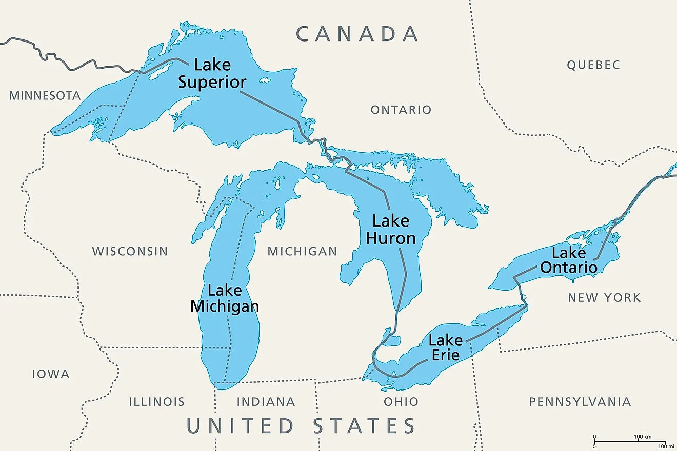
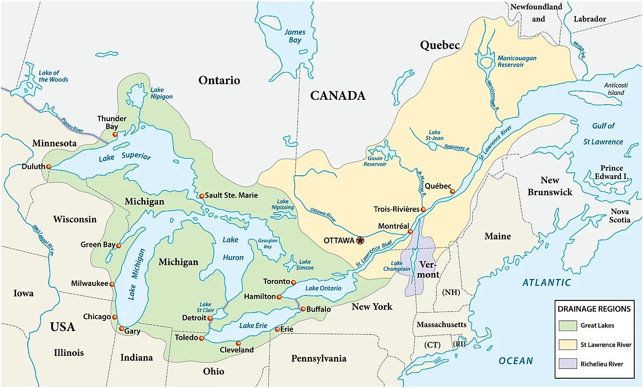
Ten lakes, out of the millions that dot the United States, hold the overwhelming majority of the country's fresh water. "Fresh water" here means water with a low enough salt content to drink, irrigate, or support freshwater fish, and therefore excludes salty bodies like the Great Salt Lake. The short answer? The five Great Lakes alone account for roughly 90% of all the fresh surface water in the United States and about a fifth of the fresh surface water on the entire planet, according to the University of Michigan's Center for Sustainable Systems and NOAA. Add the next five largest freshwater lakes in the country, and the total climbs only slightly higher, since those five combined hold less than 100 cubic miles of water, a rounding error next to Lake Superior's roughly 2,900 cubic miles solo.
These ten lakes supply drinking water to tens of millions of people, anchor multibillion-dollar fishing and shipping industries, and support wetland and forest ecosystems found nowhere else. They are also, for the most part, spectacular places to visit, ringed by national parks, lakeshores, and small towns built around the water. The list below is ranked by total volume, meaning the actual amount of water each lake holds, rather than by surface area, since a lake's footprint on a map doesn't always reflect how much water sits beneath it.
Lake Superior - 12,088 km³ (2,900 cubic miles)

By far the largest of the Great Lakes in both surface area and volume, Lake Superior holds an impressive 2,900 cubic miles (12,088 km³) of water, more than all the other lakes on this list combined. It reaches a maximum depth of 1,333 feet (406 m) and is often cited as the third-largest freshwater lake in the world by volume, behind Russia's Lake Baikal and Africa's Lake Tanganyika.
Superior's cold, rugged shoreline is also home to some of the most dramatic scenery in the Midwest. Pictured Rocks National Lakeshore in Michigan's Upper Peninsula is known for its sandstone cliffs streaked with mineral stains, while Apostle Islands National Lakeshore off the Wisconsin coast boasts a chain of 21 forested islands ringed by sea caves. In the middle of the lake itself sits Isle Royale National Park, one of the least-visited national parks in the country precisely because it's only reachable by boat or seaplane, and home to a rebounding wolf population that researchers have tracked since 1958 as part of the world's longest continuous predator-prey study.
Lake Michigan - 4,918 km³ (1,180 cubic miles)

The only Great Lake located entirely within the United States, Lake Michigan holds an estimated 1,180 cubic miles (4,918 km³) of water and reaches a maximum depth of 925 feet (282 m). Its basin touches four states, Michigan, Wisconsin, Indiana, and Illinois, and its shoreline ranges from the dunes of the north to the skyline of Chicago in the south.
Hundreds of feet above the water along Michigan's northwestern coast, towering dunes give Sleeping Bear Dunes National Lakeshore its name, one of the lake's best-known landmarks. Indiana Dunes National Park protects a quieter stretch of shoreline near Chicago that was designated a national park in 2019. Lake Michigan's water also supplies drinking water to millions of people in the Chicago and Milwaukee metropolitan areas.
Lake Huron - 3,543 km³ (850 cubic miles)

Lake Huron holds about 850 cubic miles (3,543 km³) of water, reaching a maximum depth of 751 feet (229 m) across its sprawling surface. Huron and Lake Michigan are connected at the Straits of Mackinac and share the same water level, which is why hydrologists actually classify them as a single lake, even though they're treated separately for ranking purposes because of the international border and long-standing convention.
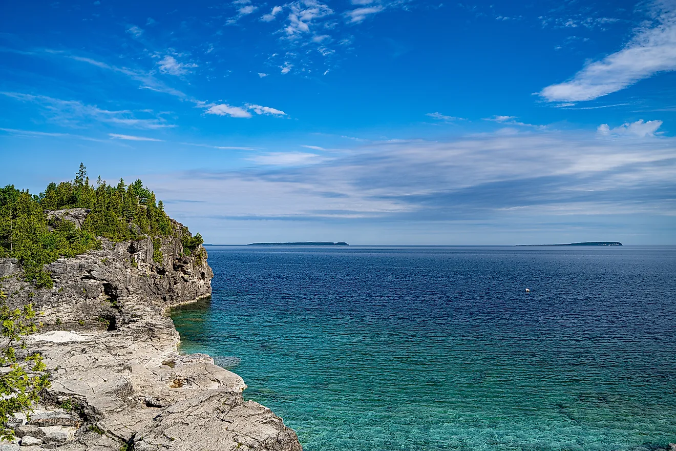
The lake's most famous landmark, Mackinac Island, sits right at that connection point, drawing visitors for its car-free streets, Victorian architecture, and fudge shops, and reachable only by ferry, private boat, or small plane. Farther north, Georgian Bay and Manitoulin Island, the largest island in any freshwater lake on Earth, add thousands of miles of rugged Ontario shoreline to Huron's basin.
Lake Ontario - 1,638 km³ (393 cubic miles)

The smallest of the Great Lakes by surface area but larger than Erie by volume, Lake Ontario holds roughly 393 cubic miles (1,638 km³) of water and reaches a maximum depth of 802 feet (244 m). It sits at the lowest elevation of the five lakes, absorbing the combined outflow of the entire Great Lakes system by way of the Niagara River before draining northeast into the St. Lawrence River toward the Atlantic.
Niagara Falls, fed by water leaving Lake Erie, thunders into the Niagara River just upstream of Ontario's shoreline, and is one of the most visited natural landmarks in North America. Further downstream, the lake narrows into the Thousand Islands region, a scattering of more than 1,800 islands popular with boaters and history buffs alike.
Lake Erie - 484 km³ (116 cubic miles)

The shallowest and smallest by volume of the five Great Lakes, Lake Erie still holds an estimated 116 cubic miles (484 km³) of water, more water than all five lakes ranked below it on this list hold combined. Its maximum depth is just 210 feet (64 m), a fraction of Lake Superior's, which means the lake warms up faster in summer and is more prone to harmful algal blooms. Even so, Erie remains one of the most productive freshwater fisheries in the world, sustained entirely by natural reproduction, with strong hatches driving its walleye and yellow perch populations.
Along its southern shore, the amusement park Cedar Point in Sandusky, Ohio, and Presque Isle State Park near Erie, Pennsylvania, draw millions of visitors each year to the lake's beaches and boardwalks. At its eastern end, the Niagara River carries Erie's outflow toward Lake Ontario, passing over Niagara Falls along the way.
Lake Tahoe, California/Nevada - 150.7 km³ (36 cubic miles)

Moving from the Great Lakes to the California-Nevada border high in the Sierra Nevada, Lake Tahoe holds about 36 cubic miles (150.7 km³) of water, making it the largest alpine lake in North America by volume. It reaches a maximum depth of 1,645 feet (501 m), the second-deepest lake in the country after Oregon's Crater Lake. Visitors come to enjoy its cold, clear water, which has historically offered visibility of nearly 98 feet (30 m). However, decades of development have chipped away at that clarity.
The lake's shoreline is dotted with protected areas, including Emerald Bay State Park and D.L. Bliss State Park, both known for some of the lake's best waterfront campgrounds, along with resort towns like South Lake Tahoe that draw skiers in winter and boaters in summer. Unlike the remote lakes further down this list, Tahoe is one of the most visited lakes in the country, a status that has only intensified pressure to protect its famous clarity; every motorized boat arriving from outside the basin must be inspected and decontaminated before it can launch.
Iliamna Lake, Alaska - 116.1 km³ (28 cubic miles)

Alaska's largest lake by surface area, Iliamna Lake covers roughly 1,000 square miles (2,600 km²), stretching 77 miles (124 km) long and reaching a maximum depth of 988 feet (301 m). By volume, it holds an estimated 28 cubic miles (116.1 km³) of water, placing it seventh among all U.S. lakes. The lake sits in southwest Alaska between Cook Inlet and Kvichak Bay, ringed by six small villages, including Iliamna and Newhalen, that depend on its waters for transportation and subsistence fishing.
Iliamna Lake serves as the nursery for the largest sockeye salmon run on Earth, with young fish spending up to half of their five-year lifespan in its cold, clear water before heading to sea. It is also home to Alaska's own lake-monster legend, with generations of local residents reporting sightings of a large, unidentified creature beneath the surface.
Lake Pend Oreille, Idaho - 54.2 km³ (13 cubic miles)

The largest lake in Idaho, Lake Pend Oreille holds about 13 cubic miles (54.2 km³) of water across 148 square miles (383 km²), plunging to a maximum depth of 1,152 feet (351 m), among the five deepest lakes in the country. French fur traders named the lake for the Kalispel people, who wore ear pendants. The U.S. Navy has taken advantage of its depth since shortly after World War II, running the Acoustic Research Detachment out of Bayview to test submarine sonar in water deep and quiet enough to mimic the open ocean.
The lake's southern shore was once the site of the second-largest naval training center in the world. That history is now preserved at Farragut State Park, where visitors can camp, hike, and launch boats onto the same waters the Navy still uses for classified research. The lakeside town of Sandpoint has grown into a popular base for exploring the area.
Becharof Lake, Alaska - 44.0 km³ (10.56 cubic miles)

Becharof National Wildlife Refuge surrounds Becharof Lake, the second-largest lake in Alaska after Iliamna Lake and the ninth-largest in the United States by volume, holding roughly 10.56 cubic miles (44.0 km³) of water. The lake stretches about 37 miles (60 km) across the Alaska Peninsula. Its name is an Americanized version of that of Russian navigator Dmitry Bocharov, who explored the area by walrus-skin boat back in 1791.
Set between Katmai National Park and Preserve to the north and the Pacific coast to the southeast, the refuge protects one of the largest populations of brown bears in North America, drawn each summer by the lake's massive sockeye salmon runs. Few roads reach this part of the peninsula, which keeps visitor numbers low but also keeps the ecosystem largely intact.
Lake Clark, Alaska - 31.7 km³ (7.6 cubic miles)

Lake Clark National Park and Preserve, established in 1980 and reachable only by floatplane or boat, protects the turquoise lake at its heart along with two active volcanoes, rainforest-lined coastline, not to mention some of the best sockeye salmon runs in the state. Lake Clark itself stretches 42 miles (68 km) long and reaches a maximum depth of 860 feet (260 m), holding an estimated 7.6 cubic miles (31.7 km³) of water, enough to rank it tenth-largest in the entire country by volume.
The lake feeds the Newhalen River, part of the watershed that sustains the Bristol Bay sockeye fishery downstream, and its clear, glacially fed water is part of what draws anglers and backcountry hikers into one of the least-visited units in the entire National Park System. The tiny settlement of Port Alsworth serves as the main gateway to this remote corner of the state.
America's Water Giants, In Perspective
Ten lakes, out of the millions that exist across the country, hold the vast majority of America's fresh water, a concentration that comes down almost entirely to the five Great Lakes and, above all, to Lake Superior alone. That kind of scale is easy to state in numbers but hard to grasp in person. A trip to any of these ten, whether it's a boat ride out to Isle Royale or a quiet afternoon on the shore of Lake Clark, leaves a lasting impression.