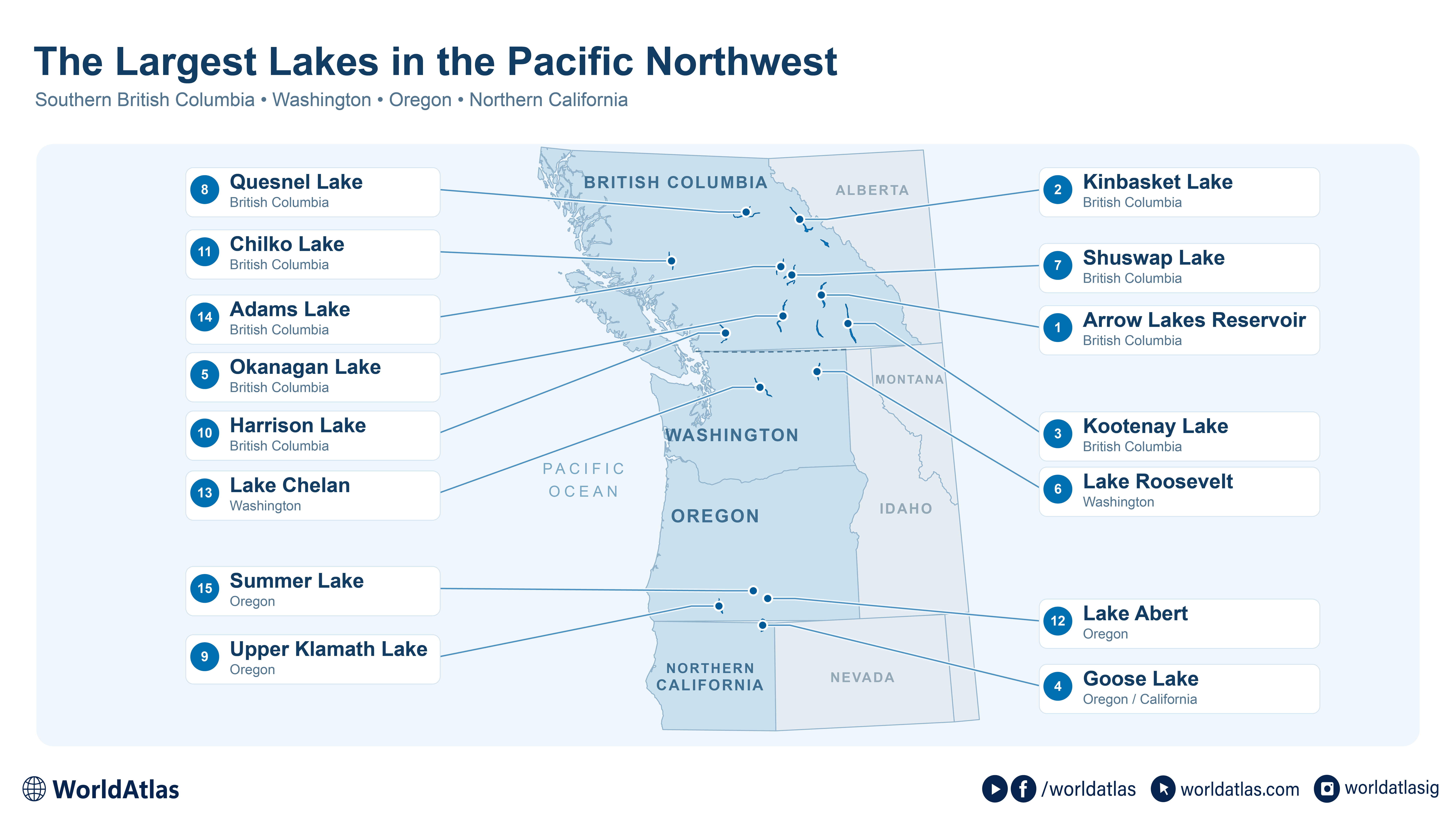
The Largest Lakes In The Pacific Northwest
Arrow Lakes Reservoir covers about 203 mi2 when full, stretching through southern British Columbia along a flooded section of the Columbia River. Farther downstream, the same river fills Washington's Lake Roosevelt. Southern British Columbia, Washington, Oregon, and northern California contain both enormous reservoirs and natural lakes occupying glacial valleys or desert basins.
Their size changes everyday travel: drivers cross Okanagan Lake on a partly floating highway bridge, while ferries carry vehicles across Kootenay Lake. The shore itself can move considerably. On Arrow, falling reservoir levels can strand boats. At Goose Lake, drought can expose an entire lakebed that held roughly 145 mi2 of water when full.
1. Arrow Lakes Reservoir, British Columbia - 203 mi2

The names Upper Arrow Lake and Lower Arrow Lake survive on maps, although Hugh Keenleyside Dam joined them into one reservoir in 1968. At full pool, it occupies approximately 203 square miles. The water extends roughly 143 miles between the Revelstoke area and Castlegar, with the Monashee Mountains on one side and the Selkirks on the other.
Along that enormous shoreline, water levels can change by about a foot in a single day. Over a year, the difference can reach roughly 66 feet. Falling water can leave boats stranded on the exposed shore.
South of Revelstoke, the original river channel crosses a broad, flat bottom for about 30 miles. Even at the reservoir's highest level, some adjoining shallows hold only two to six feet of water. Submerged stumps and shoals make the channel important for navigation.
2. Kinbasket Lake, British Columbia - 166 mi2

Upstream, Kinbasket Lake extends into the mountain valleys north of Golden and Revelstoke. Mica Dam created the present reservoir in 1973, flooding a much smaller natural lake of the same name. At full pool, the reservoir covers about 166 square miles, with long arms extending through the Rocky Mountain Trench. Mica is one of the three Canadian dams built under the Columbia River Treaty.
Floating timber complicates boat travel along the roughly 134-mile reservoir. Rivers carry wood into the water, and avalanches and landslides add more. Changing water levels move debris around the shore. BC Hydro removes floating wood and collects it on exposed ground, using tugboats and excavators. Its management program also considers where wood can be retained for fish and wetland habitat.
3. Kootenay Lake, British Columbia - 150 mi2

A drive along Highway 3A can include a 35-minute ferry crossing of Kootenay Lake between Balfour and Kootenay Bay. Vehicles roll aboard for a trip across a lake covering about 150 square miles. The long main basin lies between the Selkirk and Purcell mountains, while its West Arm extends toward Nelson. Kokanee support a fishery known for large Gerrard rainbow trout. Kokanee are sockeye salmon that spend their lives in freshwater, and they provide food for the lake's predatory trout. Upstream dams reduced the delivery of nutrients that sustain this food web. A restoration program now adds carefully measured nitrogen and phosphorus to help replace those losses. On Kootenay Lake, a tug pushes a barge carrying nutrient tanks, dispensing their contents into the water during the growing season.
4. Goose Lake, Oregon And California - 145 mi2

Goose Lake can cover about 145 square miles when full. In June 2015, satellite images showed a dry lakebed. The lake straddles the Oregon-California line east of the Cascades, where inflows depend on precipitation and mountain snowmelt. California's Willow Creek supplies much of that water, with additional inflow through Oregon's Thomas Creek. Irrigation withdrawals also affect how much reaches the basin.
The changes have exposed traces of earlier travelers. During a dry spell in the 1920s, wagon tracks appeared on ground that had been underwater, left by gold seekers decades before. Today, Goose Lake State Recreation Area occupies the Oregon shore. Migratory waterfowl are especially abundant in spring and early summer. Mule deer feed on fallen apples in an old homesteader's orchard within the campground, with the Warner Mountains rising east of the lake.
5. Okanagan Lake, British Columbia - 136 mi2

At Kelowna, part of the highway across Okanagan Lake floats. Nine concrete pontoons support the floating section of the William R. Bennett Bridge, which opened in 2008. The crossing replaced an earlier floating bridge and carries five lanes over a lake covering approximately 136 square miles.
Okanagan occupies a long valley with Vernon near its northern end and Penticton at its southern outlet. Around the lake, terraces left by earlier, higher water levels support orchards and vineyards. Kelowna's city water utility draws drinking water directly from Okanagan Lake and supplies just over half the city's population.
Water leaving Penticton continues south through Skaha Lake and Osoyoos Lake before entering Washington and joining the Columbia River. The confluence is near Brewster, downstream of Grand Coulee Dam.
6. Lake Roosevelt, Washington - 128 mi2

Grand Coulee Dam backed the Columbia River into a reservoir covering about 128 square miles, or 82,000 acres, at full pool. Lake Roosevelt occupies a long section of northeastern Washington, where boat launches and campgrounds provide access to water held for power generation and irrigation. Grand Coulee supplies irrigation water to approximately 600,000 acres in the Columbia Basin Project.
The reservoir also covered Kettle Falls, a major Indigenous salmon-fishing and gathering place. In June 1940, tribes assembled there for the Ceremony of Tears before the falls disappeared beneath the rising water. Grand Coulee blocked the salmon's upstream route as well as changing the river's shoreline. At the old town of Kettle Falls, residents moved buildings uphill to escape the flooding. The old townsite now lies beneath the reservoir.
7. Shuswap Lake, British Columbia - 120 mi2

Shuswap's approximately 120 square miles divide into four arms that meet at Cinnemousun Narrows, northeast of Sicamous. They are the Main Arm, Seymour Arm, Anstey Arm, and Salmon Arm. Those branches help explain the lake's houseboat traffic: long stretches of shoreline are reached by water. Shuswap Lake Marine Park protects 23 scattered sites, most accessible only by boat. Some have small camping areas; others have no developed facilities.
The lake's connection to the coast begins with young sockeye. Fish hatched in tributaries, including the Adams River, use Shuswap as a nursery before migrating toward the Pacific. Its single outlet, Little River, leads into Little Shuswap Lake. Summer water levels can drop roughly two to four inches daily. Boats left on shallow beaches during longer camping stays can become stranded.
8. Quesnel Lake, British Columbia - 103 mi2

Quesnel Lake extends into the Cariboo Mountains, the northernmost part of the Columbia Mountains. Its branching surface covers about 103 square miles, while the deepest water lies more than 1,600 feet below. Glacial excavation left long, steep-sided basins in a landscape where much of the shore remains difficult to reach overland.
Quesnel Lake Park protects seven separate shoreline sites, generally reached by water. Several preserve places where sockeye and kokanee spawn along the shore, while creeks provide additional spawning and rearing habitat. Grizzly bears are thought to use some of these protected areas to reach salmon late in the season.
At the western outlet, the lake drains into the Quesnel River, which eventually joins the Fraser. Salmon migrate through that river system to the Pacific.
9. Upper Klamath Lake, Oregon - 90 mi2

Upper Klamath Lake spreads across about 90 square miles at full pool, yet averages only around nine feet deep. The broad, shallow basin lies north of Klamath Falls. Link River Dam regulates its outlet, and summer water demands contribute to seasonal declines in lake level.
The lake supports endangered Lost River and shortnose suckers, fish native to the upper Klamath Basin. Large summer blooms of cyanobacteria can produce extreme changes in oxygen and pH. When blooms die and decompose, oxygen levels can fall sharply, stressing the fish.
Agency Lake lies immediately north, connected through a narrow channel. It is a separate shallow lake, adding another roughly 14 square miles beside Upper Klamath's much larger expanse.
10. Harrison Lake, British Columbia - 84 mi2

Harrison Hot Springs occupies the southern end of a lake that extends roughly 37 miles into the Coast Mountains. Harrison Lake covers about 84 square miles, with a surface only about 33 feet above sea level. Its deepest water is roughly 920 feet below the surface, and surrounding mountains rise above 6,500 feet. The Lillooet River enters at the north; the Harrison River carries water out toward the Fraser.
At Green Point in Sasquatch Park, north of Harrison Hot Springs, visitors reach a rocky beach on Harrison Lake's eastern shore. The water can stay cool in summer, and strong winds can arrive quickly. Windsurfers use the lake's open water. Within Sasquatch Park, Hicks and Deer lakes are relatively warm during summer and have sandy beaches.
11. Chilko Lake, British Columbia - 71 mi2

Chilko Lake is the largest lake in British Columbia that lies above 3,300 feet of elevation. It runs about 65 miles through a glacial trench in the Chilcotin, and its deepest water reaches roughly 1,200 feet. The valley works as an inland version of the coastal fjords, except that it opens onto a broad lava plateau rather than the sea.
Ts'yl-os Provincial Park covers the head of the lake and is co-managed by the provincial parks branch and the Xeni Gwet'in First Nation. Water leaves through the Chilko River, a salmon stream that joins the Chilcotin and then the Fraser. In the 1950s, a hydropower review passed over the lake because of its salmon.
12. Lake Abert, Oregon - 57 mi2

No fish live in Lake Abert. The water carries a heavy load of sodium carbonates and salt, and the crust along the shore can build up several inches thick. The lake spreads across about 57 square miles yet reaches only 11 feet at its deepest, held in a closed basin with no outlet and fed mainly by the Chewaucan River.
What the lake lacks in fish it makes up in brine shrimp, which draw migrating birds by the tens of thousands. Eared grebes, Wilson's and red-necked phalaropes, and American avocets stop here along the Pacific Flyway. On the east side, the Abert Rim escarpment rises more than 2,500 feet above the surface. Lake Abert and Summer Lake, about 20 miles apart, are the two remnants of a much larger ice-age lake.
13. Lake Chelan, Washington - 52 mi2

Lake Chelan reaches 1,486 feet deep, which makes it the third deepest lake in the United States, behind Crater Lake and Lake Tahoe. It stretches 50.5 miles through a glacial trough in the North Cascades, narrow and steep-sided, with a surface barely more than 1,100 feet above sea level and a bottom that drops well below it.
Stehekin sits at the roadless north end, a community of about 75 people reached by passenger boat, floatplane, or trail. It serves as a gateway into the Lake Chelan National Recreation Area and the wider North Cascades backcountry. At the south end, the water drains through the short Chelan River to the Columbia.
14. Adams Lake, British Columbia - 51 mi2

Adams Lake is a narrow trench about 63 miles long, rarely more than two miles wide. Its deepest water reaches roughly 1,500 feet, which makes it the second deepest lake in British Columbia after Quesnel. That depth and size trap incoming sediment, keeping the water that leaves the lake cool and clear.
That cool, clear water matters for salmon. The Lower Adams River runs out of the lake toward Shuswap Lake, and it carries one of North America's largest sockeye runs, which spawns in the river below the lake rather than in the lake itself. The lake takes its name from Chief Adam, a nineteenth-century Secwepemc leader.
15. Summer Lake, Oregon - 39 mi2

Summer Lake averages about a foot deep and reaches only five feet at its deepest, spread thin across roughly 39 square miles at high water. It is a shallow alkali lake with no outlet, losing most of its water to evaporation, and in some summers it dries to little more than a dust flat. One such dust storm, in February 2015, carried as far as Idaho.
John C. Fremont named the lake in December 1843, calling the snowbound ridge above it Winter Ridge and the basin below Summer Lake. Along the north shore, the Summer Lake Wildlife Area protects marshland fed by the Ana River, where more than 250 bird species have been recorded. The lake and nearby Lake Abert are the surviving pieces of the ice-age lake that once joined them.
The Nutrient Balance Below The Surface
On Kootenay Lake, crews add nutrients to support the food web. At Upper Klamath, excessive algal growth can leave fish struggling for oxygen. Kootenay's cold, naturally nutrient-poor water lost part of its incoming nutrient supply when upstream dams intercepted nutrients. Upper Klamath's shallow basin experiences heavy summer blooms and the oxygen losses that follow their collapse. On Kootenay, the nutrient additions are adjusted through the season, with more phosphorus supplied in spring and more nitrogen as summer progresses. The program expanded to Arrow Lakes Reservoir in 1999. There, the nutrients are distributed by the passenger ferry traveling between Galena Bay and Shelter Bay.