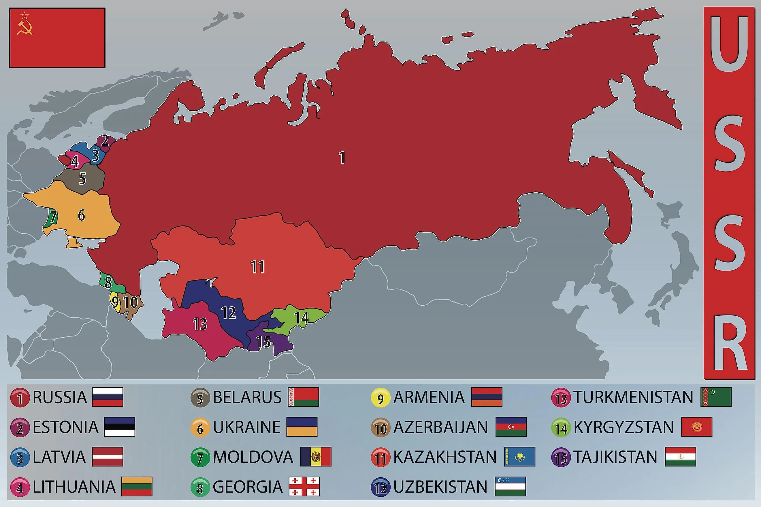
Former Soviet Union (USSR) Countries
The Soviet Union (or the Union of Soviet Socialist Republics - USSR) was a giant single-party communist state formed by the federal union of 15 national republics. It existed from 1922 to 1991. This giant transcontinental state stretched across Asia and Eastern Europe from the Pacific Ocean coast in the east to the Baltic and Black seas in the west. At the time of its existence, the Soviet Union was the world's largest country, covering roughly 8,650,000 square miles. The collapse of the Soviet Union in 1991 led to the formation of 15 sovereign states, known as the post-Soviet states. In this article, we'll take a closer look at the 15 post-Soviet countries and see how they've been faring on their journey to the present day.
The Former USSR Countries
- Armenia
- Azerbaijan
- Belarus
- Estonia
- Georgia
- Kazakhstan
- Kyrgyzstan
- Latvia
- Lithuania
- Moldova
- Russia
- Tajikistan
- Turkmenistan
- Ukraine
- Uzbekistan
Armenia

Armenia is a small, landlocked country nestled between the Black and Caspian Seas. For many years, Armenia was just another piece of the massive Soviet Union puzzle. With 11,500 square miles, the Republic of Armenia was commonly known as Soviet Armenia during the time of the USSR. The country was among the Soviet Union's constituent republics in December 1922. Soviet Armenia was created in 1920 when the Soviets seized control of the First Republic of Armenia. The country is sometimes referred to as the Second Republic of Armenia, as the first was short-lived. But under the leadership of Mikhail Gorbachev, the Armenians began to stir and form a national political party. They fought hard and, eventually, won the election, declaring sovereignty in 1990. However, it wasn't until the Soviet Union fell apart on September 21, 1991, that Armenia finally gained its independence. But Armenia isn't just a recent player on the world stage. In fact, it has a rich and storied history dating all the way back to 90,000 B.C. when the first human settlements were recorded in the region.
The country is home to many fascinating archaeological sites, including Mount Ararat, which some believe is the place where Noah's Ark came to rest after the great flood mentioned in the book of Genesis. No matter where you look in Armenia, you'll find evidence of the various civilizations that have called this place home throughout the ages.
Azerbaijan

The fascinating country of Azerbaijan has a long and tumultuous history, marked by moments of both triumph and tragedy. It existed as an independent nation from 1918 to 1920 when it came under Soviet rule as Azerbaijan SSR, and its dream of a free state ruled by the people was put on hold for a long 71 years. But as the Soviet Union's grip on power began to loosen in the late 20th century, Azerbaijan saw its chance and demanded freedom from Soviet rule. However, the Soviet Union was not willing to let go easily. In January 1990, they invaded the capital city of Baku and began firing on peaceful protesters. This event, known as Black January, marked a turning point in Azerbaijan's struggle for independence. Finally, on August 30, 1991, Azerbaijan declared its independence.
Today, Azerbaijan is a country rich in natural resources such as oil and gas, and its economy is heavily dependent on the energy sector. The population is predominantly Muslim and speaks Azerbaijani, a Turkic language. The country's culture is influenced by its Soviet history and by neighboring countries such as Iran and Turkey.
Belarus

Belarus, a landlocked country located in the heart of Eastern Europe. Bordered by Russia to the east and Ukraine to the south, Belarus has a rich and varied history. Also known as "White Russia," Belarus is the largest of the three Eastern European countries that initially formed the Soviet Union.
Following the 1917 Russian Revolution, the territory of Byelorussian SSR became one of the constituent republics of the Soviet Union in 1922. However, after the Polish-Soviet War, half of its territory came under Poland's control. In 1939, Byelorussian SSR gained territory from the Second Polish Republic when Russia invaded Poland. On July 27, 1990, the parliament of this republic declared its sovereignty and was finally granted independence on August 25, 1991. The country has a population of over 9 million, and its capital city, Minsk, is known for its Soviet-era architecture and cultural attractions.
Economically, Belarus is highly dependent on Russia, with its main exports including machinery and equipment, mineral products, chemicals, and foodstuffs. The country also has a large agricultural sector and is known for its flax production, dairy products, and potatoes. Since the dissolution of the Soviet Union, Belarus has struggled with high unemployment and low levels of foreign investment.
Estonia

This beautiful and sovereign nation is located in the northern reaches of Europe, nestled alongside the sparkling Baltic Sea. The Estonian people have a long and rich history and have always had a fierce desire for independence. In fact, a mass protest known as the Baltic Chain inspired the Estonian congress to start working toward building a free nation.
Formerly known as the Estonian Soviet Socialist Republic or ESSR, the region was a constituent republic of the Soviet Union. Initially, the ESSR was formed on the Republic of Estonia's territory on July 21, 1940, as a result of the Soviet troop's invasion on June 17, 1940, and the authorization of a puppet government endorsed by the Soviet Union. On August 9, 1940, ESSR was eventually incorporated into the Soviet Union. Nazi Germany occupied the territory between 1941 and 1944. On May 8, 1990, ESSR was renamed the Republic of Estonia, and the USSR recognized its independence on September 6, 1991. In August 1994, Russian troops withdrew from the country while its military presence ended in September 1995 after Estonia seized control of its nuclear reactor facilities in Paldiski.
Since then, Estonia has been making up for the lost time. The country has become a member of both the European Union and NATO and has experienced impressive economic growth. And it is no wonder Estonia is known for its top-notch education system and technological advances, as well as its vibrant culture and rich history.
Georgia

Nestled in the Caucasus region of Eurasia, Georgia is a country with a rich and varied history. From its ancient roots as a kingdom to its time under the rule of the Turkish and Persian empires, Georgia has always been a place of cultural diversity and significance.
Soviet Georgia was one of the Soviet Union's constituent republics admitted to the USSR on December 30, 1922. On November 18, 1989, the territory declared its independence from the Soviet Union, and on November 14, 1990, it was renamed the Republic of Georgia. Following its independence, the country struggled with economic and civil crises through most of the 1990s.
Today, Georgia is celebrated for its stunning mountain vistas, vibrant art scene, and strong agricultural industry. Its traditional music and dance are beloved by locals and visitors alike, and the country's wine-making tradition is world-renowned. Home to several UNESCO World Heritage Sites, including the ancient city of Mtskheta, the cave monastery of Vardzia, and the popular spa town of Borjomi, Georgia, is an unforgettable destination for travelers. Whether you're exploring its ancient architecture, sampling its famous wines, or taking in the breathtaking views of the Caucasus Mountains, Georgia is a place of endless beauty and fascination.
Kazakhstan

Kazakhstan is a transcontinental country located in Central Asia and Eastern Europe. Soviet Kazakhstan was established in 1936 as part of the Soviet Union. As the last of the Soviet states to declare independence, Kazakhstan joined the Commonwealth of Independent States in 1991 after the collapse of the Soviet Union. Its independence was formally recognized on December 26, 1991. Following the independence of Kazakhstan, the country was headed by Nursultan Nazarbayev.
Today, Kazakhstan is the world's largest landlocked country and is incredibly rich in natural resources, including oil, gas, coal, iron ore, gold, lead, and uranium. These resources fuel the country's economy, which is supported by several extractive operations in the energy sector.
Kyrgyzstan

Kyrgyzstan is a beautiful country located in the heart of Central Asia. Kyrgyzstan is bordered by Kazakhstan to the north, Uzbekistan to the west, and China to the east. The country has a long and storied history with roots that go back to ancient times.
Soviet Kyrgyzstan was established on December 5, 1936. The territory's name was changed to the Republic of Kyrgyzstan through a vote by the Supreme Soviet in December 1990. On December 25, 1991, Kyrgyzstan attained full independence, and on May 5, 1993, the name changed to the Kyrgyz Republic. Following its independence, the country joined the Organization for Security and Co-operation in Europe (OSCE) and the UN.
The Soviet period left a lasting mark on Kyrgyzstan, changing its landscape and educational system. Today, the most widely spoken language in Kyrgyzstan is Kyrgyz, with Russian being a close second. The country is rich in natural resources such as copper, gold, cotton, leather goods, and wool, which are all exported from Kyrgyzstan.
Latvia

Latvia is a small country located in Northeastern Europe along the beautiful Baltic Sea. Latvia has a long and complicated history, full of twists and turns. The country was originally settled by the ancient Balts, who were eventually conquered and forced into servitude by the fearsome Vikings. Later, in the mid-1200s, the whole region of Latvia came under German rule. And if that wasn't enough, Latvia was then absorbed into Russia in the early 1800s.
But despite all these setbacks, the Latvian people never lost their spirit. In 1917, they rose up in rebellion and declared independence. For a brief time, Latvia enjoyed sovereignty. But alas, it was not meant to last. In 1940, the country was forced into the Soviet Union, and its freedom was once again denied.
Soviet Latvia was established during World War II on July 21, 1940, as a puppet state of the Soviet Union. Both the European community and the US refused to acknowledge the annexation of Latvia into the USSR on August 5, 1940. Following the demise of the Soviet Union, the country restored its official name as the Republic of Latvia, attaining its full independence on August 21, 1991. It was fully recognized as an independent state on September 6, 1991, by the Soviet Union. The country's primary goal in the post-Soviet era was joining the European Union and NATO in 2004. Today, Latvia is a proud and free nation with a rich culture and history that is sure to inspire all who visit.
Lithuania

Welcome to Lithuania, a small but mighty country located in the Baltic region of northern Europe. Lithuania has a long and fascinating history, full of twists and turns. In 1939, the country was absorbed into the Russian Empire, much to the dismay of the Lithuanian people. They complained openly and actively sought help from other nations, but to no avail.
The country existed as a Soviet Union republic from 1940 to 1990 and was known as Soviet Lithuania or the Lithuanian SSR. Soviet Lithuania was established on July 21, 1940. The German Nazis occupied the territory between 1941 and 1944, and the Soviet Union later reoccupied the territory for the next 50 years. However, the US and most European nations continued to acknowledge Lithuania as an independent sovereign nation.
The Lithuanians were also not about to give up that easily. In 1990, they led the charge, and Lithuania became the first country to declare independence from the Soviet Union. The ruling empire did not take kindly to this defiance and demanded that Lithuania renounce all claims of freedom or face the consequences.
But Lithuania stood its ground. It asked other nations to recognize its independence, and the Soviet Union responded with force, occupying the capital city for a time. However, as the Soviet Union's grip on power loosened, it could not hold onto Lithuania. And in 1991, when the Soviet Union was dissolved, Lithuania finally gained its independence. Following the country's independence, Lithuania joined both NATO and the European Union in 2004 and the United Nations on September 17, 1991.
Today, Lithuania is a proud and free nation with a rich history and vibrant culture. The Lithuanian language is one of the oldest surviving languages in Europe. The country is home to many historical sites, such as castles, medieval towns, and churches that bear witness to its fascinating past.
Moldova

Welcome to Moldova, a small but mighty country tucked away in the eastern corner of Europe, sandwiched between Romania and Ukraine. You might not have heard of Moldova before, and that's because it's a relatively new player on the world stage. In fact, Moldova has never had any experience with self-governance before 1991.
Soviet Moldova was created on August 2, 1940, from a region that was annexed from Romania known as Bessarabia and parts of an autonomous state within the Ukrainian SSR. Moldova was declared a sovereign state on June 23, 1990, but was officially known as the Soviet Socialist Republic of Moldova until May 23, 1991.
The capital city of Moldova is Chișinău, which is also the largest city in the country with a population of over 675,000 people. Despite its small size, Moldova's diverse economy relies heavily on agricultural products such as tobacco, fruit, and vegetables. However, the country is in the process of diversifying and developing new industries and tourism.
Moldova is home to about 2.5 million people, making it one of the least populous countries in Europe. But don't let its size fool you - Moldova may be small, but it's got big ambitions and is working hard to carve out a place for itself in the world.
Russia

Russia is a vast transcontinental country located in Eurasia. As the largest nation in the world by area, Russia covers a landmass that stretches across much of Northern Asia and Eastern Europe. Russia is the ninth-most populous country globally, with a population of over 145 million people. Russia has a rich cultural heritage that dates back to medieval times and has been home to many great empires throughout its history, most notably the Soviet Union from 1922 to 1991.
Soviet Russia together with other Soviet Republics formed the USSR. Russia was the largest member of the Soviet Union with more than half of the USSR's total population. Soviet Russia dominated the Soviet Union during its entire history which lasted 69 years. Before 1991, the Soviet economy was the world's second-largest which was later significantly affected by inflation. The Soviet Union was experiencing political and economic turmoil by 1991, prompting the Baltic Republics to disaffiliate from the union. After the dissolution of the USSR on December 25, 1991, Russia underwent a major economic crisis leading to high death rates, low birth rates, and the collapse of social services. Meanwhile, millions of Russians were affected by poverty that increased from 1.5% to about 39 to 49%. Violent crime, extreme corruption, criminal gangs, and lawlessness characterized the 1990's in Russia. Today, Russia is a major player in world politics and continues to wield enormous influence in international affairs.
Tajikistan

Welcome to Tajikistan, a central Asian nation located in the heart of Eurasia, with China to the east and Afghanistan to the north. Tajikistan was known as Soviet Tajikistan or Tajik SSR. Soviet Tajikistan existed between 1929 and 1991. From 1927 to 1934, collective farming and the accelerated expansion of cotton production took place, particularly in the southern region of the territory. Other small-scale developments took place over time, which resulted in improved irrigation infrastructure. The territory was renamed the Republic of Tajikistan on August 31, 1991, and it declared its independence on September 9, 1991. Tajikistan was recognized as an independent state by the Soviet Union on December 26, 1991.
Unfortunately, Tajikistan's journey to independence and stability has been a rocky one. After gaining independence from the Soviet Union, the newly-free country erupted into civil war as different factions fought over the direction the new nation would take. On one side were the high-level communists, who were determined to maintain their grip on power. On the other side were the opposition forces, an alliance between Islamic and democratic groups. The civil war was long and bloody, but eventually, the communist strongman Rahman Nabiyev emerged victorious. He has been able to hold onto power ever since, winning yet another term in 2020.
Turkmenistan

Turkmenistan is a Central Asian country located between the Caspian Sea and the Karakum Desert. Turkmenistan was annexed into the Russian Empire and was later established as one of the Soviet Union's constituent republics in 1924. The Soviet Union reorganized agricultural practices, thus destroying the nomadic lifestyle in the country. On October 27, 1991, the country declared its independence from the Soviet Union, which was formally recognized on December 26, 1991.
After the Soviet Union collapsed, Saparmurat Niyazov declared himself the leader of Turkmenistan and took the title of Turkmenbashi, which means "Leader of the Turkmen." He led the country until his death in 2006 and was succeeded by Gurbanguly Berdimuhamedow. However, critics of the government say that the election was devoid of real political competition.
Ukraine

Ukraine, is a country located in Eastern Europe with a rich and varied history. Ukrainian SSR, or UkSSR, was among the Soviet Union's constituent republics and was admitted to the Soviet Union on December 30, 1922. Following the dissolution of the Soviet Society, UkSSR was renamed Ukraine, and its new constitution was approved on June 28, 1996.
Shortly after gaining its freedom, Ukraine entered into a commonwealth agreement with Russia known as the Commonwealth of Independent States or CIS. However, this agreement was not a good deal for Ukraine, which felt like it was still tied to Russia in much the same way as it was before under the Soviet Union. In 2018, Ukraine ended its relationship with Russia and went through the process of becoming an autonomous nation.
The capital and largest city of Ukraine is Kyiv, which is located in the north-central part of the country on the Dnieper River. Ukraine is the second-largest country in Europe, spanning 233,062 square miles, and has a population of 44 million people. The country is ethnically diverse, with Ukrainian being the main language spoken.
Uzbekistan

Uzbekistan is a Central Asian nation known for its rich cultural and historical heritage. Bordered by the Aral Sea to the north, Uzbekistan has long been an important part of the Silk Road network and has a storied past.
Soviet Uzbekistan was established on October 27, 1924. Between 1941 and 1945 about 1.5 million Uzbekistanis fought against Nazi Germany alongside the red army during World War II. Uzbekistan proclaimed itself a sovereign state on June 20, 1990 and declared its independence on August 31, 1991.
Uzbekistan is home to a diverse array of ethnicities, religions, and languages. It is a country with a rich cultural tapestry and a fascinating history, with a lot to offer travelers. Uzbekistan is a destination that is sure to leave a lasting impression, from its stunning natural beauty to its unique cultural traditions.

The Soviet Union's collapse was a game-changing moment that still impacts the world today. The breakup of the Soviet Union led to the creation of 15 new countries, each with its unique identity and culture. These countries have been able to chart their own paths and pursue economic and political policies that reflect the values of their citizens.Though the Soviet Union is no longer with us, its memory and influence continue to be felt in the countries that rose from its ashes.
The 15 Former Soviet Union (USSR) Countries
| Country | Capital | Area (mi2) | Population |
|---|---|---|---|
| Armenia | Yerevan | 11,484 | 2,777,970 |
| Azerbaijan | Baku | 33,400 | 10,392,475 |
| Belarus | Minsk | 80,200 | 9,514,853 |
| Estonia | Tallinn | 17,462 | 1,323,952 |
| Georgia | Tbilisi | 26,900 | 3,734,216 |
| Kazakhstan | Astana | 1,052,100 | 19,527,117 |
| Kyrgyzstan | Bishkek | 77,202 | 6,696,183 |
| Latvia | Riga | 24,926 | 1,837,332 |
| Lithuania | Vilnius | 25,200 | 2,727,846 |
| Moldova | Chisinau | 13,068 | 3,482,216 |
| Russia | Moscow | 6,601,670 | 144,631,869 |
| Tajikistan | Dushanbe | 55,300 | 10,072,337 |
| Turkmenistan | Ashgabat | 188,500 | 6,485,244 |
| Ukraine | Kyiv | 233,030 | 36,236,696 |
| Uzbekistan | Tashkent | 172,700 | 34,966,940 |


