Maps of Belarus

Belarus shares its borders with Russia to the northeast, Ukraine to the south, Poland to the west, and Lithuania and Latvia to the northwest. Covering an area of approximately 207,595 km2 (80,153 mi2), Belarus sits landlocked within Eastern Europe. The country predominantly features flat terrain shaped by glacial movements and river erosion, with an elevation ranging from the highest peak, Dzyarzhynskaya Hara at 345 meters, to the lowest point at Neman River, 90 meters above sea level.
The Belarusian Polesia occupies the southern part of the country. This region forms part of the larger Polesia area that extends into Ukraine, Russia, and Poland. Characterized by its lowlands, marshes, and peat bogs, the Belarusian Polesia serves as a significant area for freshwater reservoirs. The Pripyat River flows through this region, creating a natural waterway that has been historically important for trade and communication.
Belarusian Ridge: To the north and center of Belarus lies the Belarusian Ridge, a collection of low hills and uplands that run in a southwest to northeast direction. This ridge splits the country's river systems into two main drainage basins: one that flows to the Black Sea and the other to the Baltic Sea. The terrain in this area mainly consists of moraines, eskers, and sand dunes left by receding glaciers during the last ice age. Forests, mainly consisting of pine, spruce, and birch, dominate the landscape and provide essential timber resources.
The Central Belarusian Plateau spans the central and northeastern parts of the country. Unlike the other regions, it presents a more balanced mixture of forests and arable land. Numerous rivers crisscross the plateau, with the most notable being the Berezina, which has served as a crucial transportation route throughout history. Additionally, the plateau contains deposits of peat, clay, and sand.
The Neman Basin lies in the northwest and serves as another significant geographical region. It features the Neman River, which is one of the major rivers in Belarus and flows westward into the Baltic Sea. The basin is crucial for agriculture, particularly for the cultivation of potatoes, flax, and grains. It also contains several lakes, such as Lake Narach, the largest lake in Belarus.
Bodies of Water: Many streams and over 10,000 small lakes are scattered across the country. Among the rivers, the Dnieper, flowing south towards the Black Sea, stands as the most significant. Originating in Russia, it enters Belarus and passes through the Belarusian Ridge and the Central Belarusian Plateau. The river has been dammed at various points to create reservoirs that serve both agricultural and hydroelectric purposes. Belarus has few large natural lakes, but reservoirs formed by damming rivers play an essential role in water storage and energy generation. The Vileika Reservoir and the Zaslavl Reservoir are notable examples, both of which are on the Svisloch River.
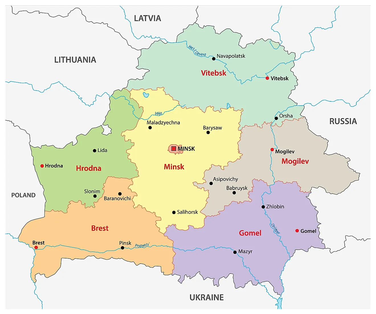
Belarus (officially, the Republic of Belarus) is divided into 6 regions (voblastsi, sing. voblasts) and 1 municipality (horad). The regions are: Brest, Gomel, Grodno, Mogilev, Minsk and Vitebsk. Horad Minsk (Minsk City) is the municipality. The regions are further subdivided into a total of 118 raions (districts). Minsk city has 9 raions and enjoys special status as the national capital.
Situated on the slopes of the Minsk hills is, Minsk – the capital, the largest and the most populous city of Belarus. It is also the major administrative, cultural, educational, industrial and economic center of the country.
Where is Belarus?

Belarus is a landlocked country in Eastern Europe. It is geographically positioned both in the Northern and Eastern hemispheres of the earth. Belarus is bordered by 5 countries: by Russia in the north and east; by Ukraine in the south; by Poland in the west; by Lithuania and Latvia in the northwest.
Belarus Bordering Countries: Ukraine, Russia, Lithuania, Latvia, Poland.
Regional Maps: Map of Europe
Outline Map of Belarus


Key Facts
| Legal Name | Republic of Belarus |
|---|---|
| Flag |
|
| Capital City | Minsk |
| 53 54 N, 27 34 E | |
| Total Area | 207,600.00 km2 |
| Land Area | 202,900.00 km2 |
| Water Area | 4,700.00 km2 |
| Population | 9,466,856 |
| Major Cities |
|
| Currency | Belarusian rubles (BYB/BYR) |
| GDP | $63.08 Billion |
| GDP Per Capita | $6,663.30 |
This page was last updated on October 9, 2023