The Coldest Ocean Beaches In America
A wetsuit is standard equipment for the surfers who paddle out at Surfer's Beach on Kodiak Island, Alaska. Even in August, NOAA's monthly average for the water around Kodiak reaches only 52.9 degrees Fahrenheit. Thousands of miles south, summer beachgoers run into similarly cold Pacific water along parts of Washington, Oregon, and Northern California.
Cold ocean beaches are not limited to the West Coast. Sand Beach in Maine's Acadia National Park normally stays between 50 and 60 degrees, while the Atlantic off Assateague Island can fall to around 40 degrees in winter. Water temperatures change by season, weather, tides, currents, and measurement point, so there is no fixed ranking that remains accurate all year. These eight beaches are among the places where federal and state sources document notably cold ocean conditions.
Surfer's Beach, Alaska

The name Surfer's Beach may sound more fitting for California than Alaska, but this stretch of Kodiak Island coastline really does draw surfers. The water stays exceptionally cold largely because of Kodiak Island's high northern latitude and its exposure to the cold waters of the Gulf of Alaska. NOAA records monthly average water temperatures around Kodiak ranging from 36.7 degrees Fahrenheit in February to only 52.9 degrees in August. Even at the warmest point of the year, the water remains cold enough that surfers need proper cold-water gear.
Those temperatures have not stopped people from paddling out. The Pasagshak area is known for surfing as well as hiking, kayaking, fishing, and wildlife watching. A dry-land alternative is the access trail down to the beach, which works for hiking and picnicking or for scanning the coastline for wildlife.
Nearby Pasagshak Bay is worth the drive for more than the surf. Alaska State Parks reports that the area supports whales, seals, dolphins, eagles, seabirds, and brown bears. The Pasagshak River is also a major sport-fishing stream, with runs of sockeye, pink, chum, and silver salmon along with Dolly Varden. Camping is available at Pasagshak River State Recreation Site.
Rialto Beach, Washington

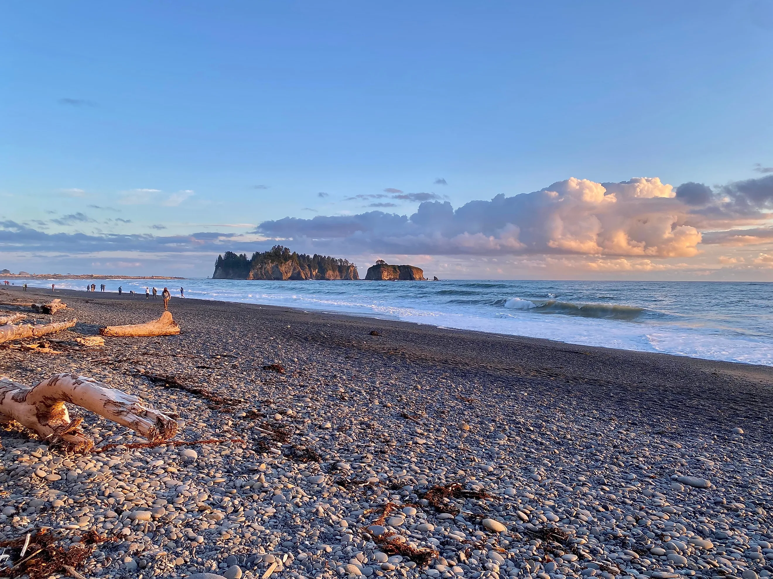
Driftwood logs and sea stacks line the shoreline at Rialto Beach, but the cold Pacific water is just as characteristic of this section of Olympic National Park. One reason it remains so chilly, even in summer, is coastal upwelling. NOAA explains that spring and summer winds along the Olympic Coast push warmer surface water offshore, allowing colder water from deeper in the Pacific to rise and replace it.
Low tide opens up another side of the beach. Hole-in-the-Wall, a sea-carved arch 1.5 miles north of the Rialto Beach trailhead, has tide pools around its rocky base. NPS recommends arriving at least 30 minutes before the lowest tide and warns against passing through the arch once water begins covering its floor.
The hike to Hole-in-the-Wall calls for as much attention to the tide as to the temperature. High water can make sections of the coast impassable, and sneaker waves can reach farther up the beach than expected.
Cannon Beach, Oregon

A warm afternoon at Cannon Beach does not mean warm ocean water. Satellite-derived averages put the water near 48 degrees Fahrenheit in February and only about 58 degrees at its late-August peak, which is the warmest it gets all year. The Pacific stays particularly cold here because of coastal upwelling. From spring into summer, northerly winds along Oregon push warmer surface water away from shore, allowing colder water from deeper in the ocean to rise toward the surface. NOAA identifies this seasonal process as an important part of Oregon's coastal ocean conditions.
Low tide is a better reason to get close to the water. Haystack Rock rises 235 feet above the beach, and the exposed rocks around its base contain tide pools with anemones, sea stars, crabs, and other intertidal animals. The offshore rock is protected as part of Oregon Islands National Wildlife Refuge.
Look higher from May through August. Tufted puffins nest on Haystack Rock during their breeding season, although spotting one can take patience. The refuge's rocks and islands are closed to public entry to protect nesting seabirds and other wildlife.
Gold Bluffs Beach, California

Northern California's Pacific coast is much colder than its latitude might suggest, and coastal upwelling is a major reason. Seasonal winds move surface water away from shore, allowing colder water from deeper in the Pacific to rise along the coast. At the nearest monitored points, Trinidad to the south and Crescent City to the north, averages compiled from federal ocean data hold near 51 degrees Fahrenheit through winter and climb only into the low 50s by late summer. At Gold Bluffs Beach, the National Park Service describes the ocean as "very cold," notes that currents are swift, and specifically says this is not a good swimming beach.
The gray-sand shoreline runs beside Prairie Creek Redwoods State Park in Redwood National and State Parks. Seals use the coast, and western snowy plovers nest and rest on the beach. Sections of the California Coastal Trail also pass through the area.
Gold Bluffs shares its access road with another unusual landscape. Continue along narrow, unpaved Davison Road to the Fern Canyon parking area, then follow the trail into a canyon whose walls rise 50 to 80 feet and support dense ferns and mosses.
Point Reyes Beach, California

The ocean at Point Reyes Beach stays cold in part because of the California Current, which carries cool water southward along the West Coast. Seasonal coastal upwelling makes conditions colder still by bringing deeper Pacific water toward the surface. Water temperatures around Point Reyes can hover near 50 degrees Fahrenheit, cold enough that the National Park Service lists hypothermia as one of the area's ocean hazards.
Temperature is not the only reason to stay cautious. North and South beaches face the open Pacific, where large surf, rip currents, and sneaker waves have pulled people into the water. NPS warns that North Beach is not safe for swimming because of its frequently large surf.
December through January is another time to watch the water from dry land. Gray whales pass Point Reyes during their winter migration, with another migration period in March and April. NPS suggests scanning the horizon from North Beach for the whales' blows.
Sand Beach, Maine
People swim at Sand Beach in Acadia National Park all summer, but the water in the Gulf of Maine stays decidedly cold. Ocean water normally ranges from 50 to 60 degrees Fahrenheit, and even during its warmest period in August, it generally reaches only 55 to 60 degrees.
The circulation of the Gulf of Maine helps explain why. According to the National Park Service, cold water enters the gulf from the north and through deeper channels connected to the Atlantic, while the region receives relatively little direct warming from the Gulf Stream. The result is ocean water that remains cool even when summer air temperatures make swimming look inviting.
Several trails start within reach of the sand for a change of plan. Great Head Trail climbs from the eastern end of Sand Beach to open ledges above the coast, reaching a high point 145 feet above sea level. The Beehive is the more demanding choice, using iron rungs and ladders on exposed sections of the climb. Ocean Path follows the coastline in the other direction toward Thunder Hole and Otter Point.
Cape Cod National Seashore, Massachusetts

Cape Cod does not match Alaska for the lowest summer water temperatures, but the surrounding Atlantic stays cold for a long stretch of each year. Its northeastern location means substantial seasonal cooling, and the Cape sits near the meeting zone of colder waters from the north and warmer waters associated with the Gulf Stream farther offshore. The National Park Service puts average summer ocean temperatures at Cape Cod National Seashore between 60 and 70 degrees Fahrenheit, while winter water becomes considerably colder.
Six NPS-managed swimming beaches line the national seashore. Race Point Beach near Provincetown faces north toward Massachusetts Bay, while Coast Guard, Nauset Light, Marconi, Head of the Meadow, and Herring Cove cover different stretches of the Cape's shoreline.
Cold water is only one consideration when swimming. NPS warns about shore break, rip currents, and strong undertows. White sharks also inhabit Cape Cod waters, so swimmers are advised to stay away from seals and schools of fish, remain close to shore, and watch for shark-warning flags.
Assateague Island National Seashore, Maryland and Virginia

Assateague Island belongs among America's cold ocean beaches primarily because of how dramatically the Atlantic cools during winter. Its mid-Atlantic location means it does not receive the year-round warmth found farther south, and the seasonal loss of solar heating pushes nearshore water temperatures sharply downward. Atlantic water that can reach the mid- to upper 70s during a warm summer drops to around 40 degrees Fahrenheit in winter, according to the National Park Service.
The geography is straightforward but important. The Atlantic Ocean runs along the eastern side of the barrier island, and Assateague's bays are to the west. The national seashore's boundary reaches a half-mile into the Atlantic.
Water temperature also has a lot to do with what appears offshore. Dolphins hunt schools of fish around Assateague, while sea turtles, marine mammals, fish, and migratory birds move through the region as seasonal conditions change. On land, the island's horses roam beaches, marshes, and developed areas, but NPS requires a distance of at least 40 feet.
Cold Water Behind a Warm Beach Day
The sharpest surprise may come in August rather than January. Sand Beach can top out in the 50s during Maine's summer, and the water around Kodiak averages under 53 degrees even at its August peak. Along the Pacific Northwest and California, upwelling can bring deep, cold water toward shore while the weather on land feels considerably warmer.
Temperature is only one reason to check conditions before getting in. A low tide opens the route to Hole-in-the-Wall at Rialto Beach. A sneaker wave can turn Point Reyes dangerous in seconds. At Gold Bluffs Beach, NPS skips the ambiguity altogether and says outright that the swift currents and very cold water make it a poor place to swim.