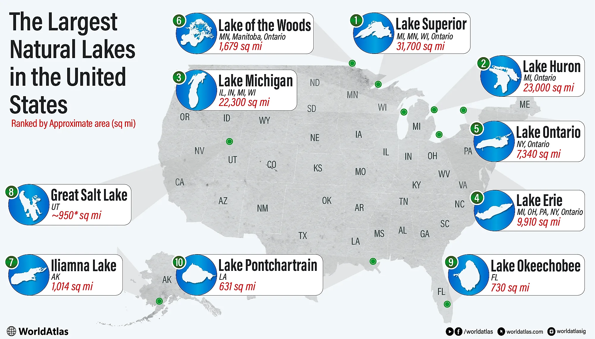
The 10 Largest Natural Lakes in the U.S. by Surface Area
The largest natural lakes in the US include five Great Lakes and five giants that show how water resources vary from the Upper Midwest to the Gulf Coast. Using the approximate surface areas, Lake Superior (31,700 mi2), Lake Huron (23,000 mi2), Lake Michigan (22,300 mi2), Lake Erie (9,910 mi2), and Lake Ontario (7,340 mi2) together contribute about 95% of the combined area of the top ten. Their U.S. shorelines span Michigan, Minnesota, Wisconsin, Illinois, Indiana, Ohio, Pennsylvania, and New York, concentrating the largest lake surfaces in a single basin.
The remaining lakes broaden the geographic and chemical range. Lake of the Woods (1,679 mi2) is a vast border lake whose U.S. waters lie in northern Minnesota. Iliamna Lake (1,014 mi2) is the largest lake fully within a single U.S. state by area, highlighting Alaska's scale and remoteness. The Great Salt Lake (950 mi2, highly variable) is the list's major saline outlier, with a surface area that rises and falls with water levels. Lake Okeechobee (730 mi2) anchors Florida's inland hydrology. Lake Pontchartrain (631 mi2) is a shallow, brackish lake/estuary north of New Orleans.
The Largest Natural Lakes in the US
| Rank | Lake | Approx. Surface Area (mi2) |
|---|---|---|
| 1 | Lake Superior | 31,700 |
| 2 | Lake Huron | 23,000 |
| 3 | Lake Michigan | 22,300 |
| 4 | Lake Erie | 9,910 |
| 5 | Lake Ontario | 7,340 |
| 6 | Lake of the Woods | 1,679 |
| 7 | Iliamna Lake | 1,014 |
| 8 | Great Salt Lake | 950 (highly variable) |
| 9 | Lake Okeechobee | 730 |
| 10 | Lake Pontchartrain | 631 |
1. Lake Superior - 31,700 mi2

Lake Superior is the largest lake in the United States and the world's largest freshwater lake by surface area, spanning about 31,700 square miles. Shared by the U.S. and Canada, it holds roughly 10% of the world's surface freshwater, an estimated 2,900 cubic miles. The lake's maximum depth reaches 1,332 feet off the southeastern part of the lake, and its average depth of 483 feet makes it the deepest and coldest of the Great Lakes.
Superior's immense size moderates regional temperatures, creating distinctive microclimates along its shores. The lake drains through the St. Marys River at Sault Ste. Marie into Lake Huron, forming part of the Great Lakes-St. Lawrence Seaway. Known for sudden storms and powerful waves exceeding 25 feet, Superior has claimed over 350 shipwrecks, including the famous Edmund Fitzgerald in 1975. Its watershed includes pristine forests and rocky coastlines, supporting species such as lake trout and whitefish, making it both an ecological and hydrological cornerstone of North America's Great Lakes system.
2. Lake Huron - 23,000 mi2

Lake Huron is the second-largest lake in the United States by surface area, covering approximately 23,000 square miles. It forms part of the U.S.-Canada border and touches Michigan on the American side. Hydrologically, Huron is closely linked to Lake Michigan; the two are connected by the Straits of Mackinac and share the same water level, though they are officially recognized as separate lakes. Huron's basin includes Georgian Bay and the North Channel, contributing to its extensive shoreline, over 3,800 miles, the longest of any Great Lake.
Huron also contains over 30,000 islands, including Manitoulin Island, the world's largest freshwater island, which lies entirely within Canadian waters. The lake's maximum depth reaches 750 feet, with an average depth of 195 feet. Huron receives inflow from Lake Superior via the St. Marys River and drains into Lake Erie through the St. Clair River. Historically significant in the fur trade and maritime transport, Huron has also been a major site for shipwrecks, many now protected within the Thunder Bay National Marine Sanctuary off Michigan's coast.
3. Lake Michigan - 22,300 mi2

Lake Michigan is the third-largest lake in the United States by surface area, covering approximately 22,300 square miles. It is the only one of the five Great Lakes located entirely within the United States, bordered by four states: Illinois, Indiana, Michigan, and Wisconsin. The lake's maximum depth is 925 feet, with an average depth of 279 feet. It contains roughly 1,180 cubic miles of freshwater, making it a vital drinking water source for over 12 million people.
Major cities along its shores include Chicago and Milwaukee, both of which rely on the lake for commerce, recreation, and municipal water supply. Lake Michigan is connected to Lake Huron by the Straits of Mackinac, and the two share the same water level. The lake is known for its distinctive sand dunes, particularly along the eastern shoreline in Michigan, some exceeding 200 feet in height. The lake also supports commercial and sport fisheries, with native species such as lake trout and whitefish. Lake Michigan's ports, harbors, and transportation links have played a central role in Midwestern economic development since the 19th century.
4. Lake Erie - 9,910 mi2

Lake Erie, the fourth-largest lake in the United States by surface area, spans approximately 9,910 square miles and borders four U.S. states: Michigan, New York, Ohio, and Pennsylvania. It is the shallowest of the five Great Lakes, with an average depth of just 62 feet and a maximum depth of 210 feet, which makes it the warmest and most biologically productive of the group. Erie serves as a vital water source for over 11 million people and supports a robust commercial and recreational fishing industry, particularly for species such as walleye and yellow perch.
The lake receives inflow from the Detroit River and discharges through the Niagara River into Lake Ontario, contributing significantly to the hydrology of the Great Lakes-St. Lawrence system. Erie's basin is densely populated and heavily industrialized, making it especially vulnerable to nutrient runoff and algal blooms, an ongoing concern for water quality management. The lake contains numerous islands, particularly in the western basin, including South Bass Island, home to the village of Put-in-Bay. Its shallow waters also make it prone to rapid weather changes and lake-effect snowstorms.
5. Lake Ontario - 7,340 mi2

Lake Ontario, the easternmost and smallest of the Great Lakes by surface area, covers approximately 7,340 square miles. Located on the U.S.-Canada border, its American shoreline lies entirely within New York State. Despite its relatively small surface area, Lake Ontario is the second-deepest of the Great Lakes, with a maximum depth of 802 feet and an average depth of 283 feet. It holds more water than Lake Erie due to its depth, storing an estimated 393 cubic miles of freshwater.
The lake receives inflow primarily from the Niagara River, which connects it to Lake Erie, and drains into the Atlantic Ocean via the St. Lawrence River, making it the final link in the Great Lakes-St. Lawrence Seaway. Ontario's shoreline includes the cities of Rochester and Oswego and supports significant shipping, power generation, and recreation. Its deeper, colder waters are less biologically productive than Lake Erie but support cold-water species such as lake trout and salmon. The lake is also vulnerable to pollution and invasive species, including zebra mussels and round gobies, which have altered native ecosystems since the late 20th century.
6. Lake of the Woods - 1,679 mi2

Lake of the Woods ranks sixth among the largest natural lakes in the United States by surface area, covering approximately 1,679 square miles. Located at the intersection of Minnesota, Manitoba, and Ontario, only about 307 square miles lie within the U.S., entirely in northern Minnesota. Despite its partial location, it is counted due to its significant size and hydrological importance.
The lake is renowned for its complex geography, containing over 14,500 islands, more than any other lake in the contiguous U.S., and over 65,000 miles of shoreline, including island coasts. Its irregular shape and island-rich terrain support diverse ecosystems and habitats for fish, birds, and other wildlife. Lake of the Woods has an average depth of 27 feet, with a maximum depth of around 210 feet in Canadian waters. It drains northward through the Winnipeg River into Lake Winnipeg and eventually into Hudson Bay. The lake supports both commercial and recreational fishing, especially for walleye and northern pike. It also plays a significant role in U.S.-Canada water management, monitored by the International Joint Commission under the Boundary Waters Treaty of 1909.
7. Iliamna Lake - 1,014 mi2

Iliamna Lake is the largest lake entirely within a single U.S. state, covering approximately 1,014 square miles in southwestern Alaska. Located on the Alaska Peninsula, it measures about 77 miles long and up to 22 miles wide, making it the seventh-largest lake in the United States by surface area. Despite its size, Iliamna is relatively shallow compared to the Great Lakes, with a maximum depth of 988 feet and an average depth of around 144 feet.
The lake is freshwater and drains west into Bristol Bay via the Kvichak River, a key component of one of the world's most productive salmon fisheries. Iliamna supports major runs of sockeye salmon, as well as lake trout, Arctic char, and rainbow trout, making it an essential ecological resource. The lake is also notable for its isolated setting and limited human development, with surrounding communities accessible only by air or boat. Indigenous Alaskan communities have relied on its fishery for generations. Iliamna has also drawn attention due to local legends of a large, unidentified aquatic creature, though no scientific evidence supports its existence. The lake remains largely pristine and ecologically intact.
8. Great Salt Lake - 950 mi2

The Great Salt Lake is the largest natural lake west of the Mississippi River and the eighth-largest in the United States by surface area, though its size fluctuates dramatically with seasonal and long-term water levels. Historically, the lake has ranged from over 3,000 square miles in the 1980s to less than 850 square miles in 2022, due to drought and upstream water diversion. Located in northern Utah, it is a terminal lake with no outlet, resulting in high salinity, up to 27% in some areas, nearly eight times saltier than the ocean.
The lake is the largest remnant of ancient Lake Bonneville, which once covered much of the Great Basin. The Great Salt Lake has an average depth of less than 20 feet and contains several islands, including Antelope and Gunnison Islands. It plays a crucial ecological role, supporting millions of migratory birds annually and hosting unique microbial and brine shrimp populations. The lake also contributes to Utah's economy through mineral extraction and brine shrimp harvesting. Its shrinking footprint has raised significant environmental and public health concerns due to exposed lakebed dust containing arsenic and other harmful materials.
9. Lake Okeechobee - 730 mi2

Lake Okeechobee is the ninth-largest natural lake in the United States by surface area and the largest in Florida, covering approximately 730 square miles. It lies in the southern portion of the Florida Peninsula and is a central component of the region's hydrology. Okeechobee is notably shallow, with an average depth of just 9 feet, making it highly sensitive to changes in rainfall and runoff.
The lake serves as a crucial freshwater reservoir, historically feeding the Everglades through natural overflow. Today, it is regulated by an extensive system of canals, levees, and locks managed by the U.S. Army Corps of Engineers. Lake Okeechobee supports commercial and recreational fishing, with populations of largemouth bass, crappie, and bluegill. However, it is also the focus of major environmental concern due to agricultural runoff that contributes to harmful algal blooms and nutrient loading. Its surrounding Herbert Hoover Dike, a 143-mile earthen dam, is undergoing a multi-billion-dollar rehabilitation project to improve flood control. Okeechobee remains vital to South Florida's water supply, flood protection, and ecosystem health, while also posing significant water management challenges in the face of population growth and climate change.
10. Lake Pontchartrain - 630 mi2

Lake Pontchartrain, located in southeastern Louisiana, is the tenth-largest natural lake in the United States by surface area, covering approximately 631 square miles. Although commonly referred to as a lake, it is technically a brackish estuary, connected to the Gulf of Mexico via the Rigolets and Chef Menteur Pass. Its waters exhibit variable salinity, supporting both freshwater and salt-tolerant species. The lake is shallow, with an average depth of just 12 to 14 feet, which contributes to its vulnerability during storm surges, as seen during Hurricane Katrina in 2005.
Lake Pontchartrain plays a central role in the New Orleans metropolitan region, lying just north of the city and serving as a critical buffer for stormwater and flood control. The 24-mile-long Lake Pontchartrain Causeway, one of the world's longest continuous bridges over water, spans the lake and is vital for regional transportation. The Pontchartrain Basin is ecologically significant, supporting wetlands, fisheries, and migratory bird habitats. Long-term water quality has been impacted by urban runoff and nutrient loading, but restoration efforts under the Lake Pontchartrain Basin Foundation have improved conditions since the early 2000s.