The Fastest-Declining Lake Levels in North America
Five of the fastest-drying lakes in North America are all found in the Southwest portion of the United States. Although lake levels continuously fluctuate, drought, groundwater depletion, and water diversion have resulted in a steady decrease over decades. Lake Powell and Lake Mead have lost at least two-thirds of their water, while Great Salt Lake has reached its lowest recorded level since measurements began in 1847. In California, the Salton Sea loses about 1,300,000 acre-feet of water to evaporation annually, while the surface elevation of Walker Lake in Nevada has dropped by more than 150 feet since 1882. Read on to discover how this is happening and why it matters.
Lake Mead

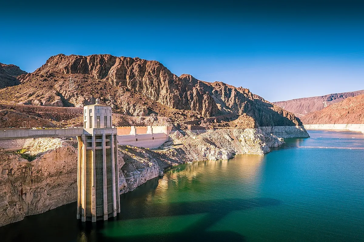
Lake Mead, shared by portions of Nevada and Arizona, is a reservoir on the Colorado River and the largest of its kind in the US. At full capacity, the surface area is about 250 square miles, and it can hold up to 9.3 trillion gallons of water with more than 550 miles of shoreline. The water level, which has been decreasing for decades, is now less than 10 feet from reaching critical water-shortage levels. Drought and rising water demand due to population growth and industry are to blame. Las Vegas, which relies on the lake for its water, has grown from less than 5,500 people when the Hoover Dam was built in the 1930s to more than 2 million. While the need has grown, the water level has diminished due to a drought that has, since 1999, decreased the flow of water from the Colorado River.
Lake Powell

Lake Powell sits north of Lake Mead on the Columbia River and stretches across the Utah/Arizona borders. It, too, is facing critically low water levels due to a lack of inflow. As the second-largest man-made lake in North America, the reservoir has a surface area of about 161,000 acres and can hold up to roughly 27 million acre-feet of water. Also like Lake Mead, the issue of a decades-long drought is coupled with an increase in demand due to population growth, and challenges related to government policy and resource management. The storage capacity of Lake Powell is essential for the Colorado River Basin system, which supplies water to more than 40 million people across seven states and Mexico, but persistent drought has resulted in steady and significant losses. The lake is currently at about 25% of its full pool level and is facing the possibility of a dead pool scenario, which refers to the point at which water can no longer pass through the dam and supply the river system below. Predictions indicate that the reservoir could reach what's called "minimum power pool" status within the year, at which point the hydroelectric dam can no longer function.
Great Salt Lake

The largest natural lake west of the Mississippi River and the largest saltwater lake in the Western Hemisphere is also drying up. Since the mid-1980s, the Great Salt Lake in Utah has steadily declined and is losing about four inches a year. Now at a historic low, the Great Salt Lake has lost about 73% of its water, 60% of its surface area, and its shorelines have receded by as much as 20 miles. Climate change, water diversion for human consumption and agriculture, and reduced river inflow are, once again, the main culprits here. The average temperature in Northern Utah has gone up as much as 4 °F since 1900, and this has led to higher evaporation rates, a smaller snowpack, and persistent drought conditions. Water being diverted for municipal and industrial use has also resulted in an 11-foot drop in the lake’s elevation.
Salton Sea

Salton Sea is the largest lake by surface area in California, but its water level is steadily decreasing due to evaporation and reduced agricultural drainage water. Its capacity is about 7.5 million acre-feet, and it has a fluctuating surface area of about 376 square miles. It is projected that parts of the Salton Sea’s North Shore will recede 150 meters by 2030 and another 172 meters by 2041. The lake at one time relied on agricultural return flows; however, with increased scarcity and rising costs, farmers have found ways to be more efficient with their water use, and improved irrigation systems and techniques have resulted in a reduction of drainage. The return flows that are going into the lake are not enough to match the approximately 1,300,000 acre-feet of water per year that evaporates, hence the decline.
Walker Lake

Walker Lake is a terminal lake in Western Nevada, meaning it has no natural outlet other than evaporation. The lake has a surface area of about 30,000 acres and is fed by the Walker River, as well as some snowmelt from the Sierra Nevada. Much of its water gets diverted before it reaches its destination, however. This lake’s decline started about a century ago when farmers and ranchers started using its water to irrigate alfalfa fields and pasture grass. It has since lost a whopping 90% of its volume. High evaporation rates have also increased the salinity of the water, making the lake about half as salty as seawater, which has obviously had a significant impact on fish and other wildlife. While there were originally upwards of 17 fish species that lived in Walker Lake, it no longer supports fish life, and what was once a popular destination for tourism and recreation has become the focal point of significant restoration and conservation efforts.
Federal, state, and local governments are working on ways to mitigate a brewing water shortage that is already affecting millions of people in the Southwest. Meanwhile, farmers, residents, and industries that rely on Lake Powell, Lake Mead, Great Salt Lake, Salton Sea, and Walker Lake in Nevada steadily watch water levels decline. There is much work to be done in the coming years and future generations to restore these essential reservoirs and ecosystems to healthy states, and in the meantime, they serve as important reminders of the impact human development and climate change can have on the natural world.