The Longest Pedestrian Bridges In The United States
Many of the longest pedestrian bridges in the United States were built to carry trains or cars before being reclaimed by walkers and cyclists. Today, they are popular tourist attractions and lifelines for commuters who make the round-trip part of their daily routine. This list counts distinct, elevated bridges whose primary current purpose is pedestrian and/or bicycle travel. Converted road and railroad bridges are included, but boardwalks, multi-structure trail systems, and active vehicular or transit bridges with pedestrian lanes are not. Ranked by total published bridge length, the following nine structures are the longest to meet the criteria.
Walkway Over the Hudson, New York - 6,768 feet

At 1.28 miles (6,768 feet) long and spanning the Hudson River, Walkway Over the Hudson is the longest elevated pedestrian bridge in the U.S. It was first opened in 1889 as the Poughkeepsie-Highland Railroad Bridge, and, at that time, served as an industrial rail artery connecting the coal fields in Pennsylvania with New England factories. In 1974, a fire caused its rail operations to cease, and the bridge was left to rust for decades. It underwent a revitalization project thanks to local grassroots advocates and reopened in 2009 as the Walkway Over the Hudson State Historic Park in Highland, New York.
The cantilever and steel truss bridge is 212 feet above the water. An elevator is available to carry passengers to the walkway bridge. Those who have walked across the bridge say that it offers awe-inspiring, panoramic views of the Catskill Mountains. The ADA-compliant bridge is also part of the Empire State Rail Trail and hosts festivals and marathons throughout the year. It draws thousands of tourists annually. Walkway Over the Hudson is open daily from 7 a.m. to dusk (weather permitting). Admission to the bridge is free.
Big Dam Bridge, Arkansas - 4,226 feet

At 4,226 feet long, Big Dam Bridge in Little Rock, Arkansas, is the longest pedestrian and bicycle bridge built specifically for non-motorized traffic in North America. Rising 90 feet above the Arkansas River, construction of this post-tensioned concrete girder bridge was completed in 2006. Big Dam Bridge spans the lock and dam, connecting Murray Park in Little Rock to Cook's Landing Park in North Little Rock.
Big Dam Bridge is a hub of the Arkansas River Trail Loop, which connects to roughly 40 miles of riverside trails. It is fully ADA-accessible and features LED illumination at night. The bridge is open 24 hours a day, 365 days a year, with no admission fee.
John Seigenthaler Pedestrian Bridge, Tennessee - 3,150 feet

One of Nashville's most famous attractions, the John Seigenthaler Pedestrian Bridge is a historic truss bridge spanning 3,150 feet over the Cumberland River. It was built between 1907 and 1909. Originally called the Sparkman Street Bridge, it became known as the first major bridge in North America to use concrete arched trusses. Rising to a height of 70 to 80 feet over the river, the bridge carried streetcars and vehicles before it was closed to cars in 1998.
In 2003, Nashville reopened the bridge as a dedicated pedestrian and bicycle pathway. At that time, it was called the Shelby Street Bridge. The bridge was renamed in 2014 to honor a local journalist and civil rights advocate, John Seigenthaler, who once saved a suicidal man from jumping off the bridge in the 1950s. The bridge is free and open to the public 24 hours a day, seven days a week.
Meridian Bridge, South Dakota/Nebraska - 3,029 feet

The historic Meridian Bridge is a double-decker bridge across the Missouri River, connecting Yankton, South Dakota, to Cedar County, Nebraska. The bridge was built by local business leaders who formed the "Meridian Highway Bridge Company." Opened in 1924, the 3,029-foot-long bridge was the only vertical lift bridge in Nebraska and South Dakota. From 1953, the top level carried northbound traffic, and the bottom level carried southbound traffic. The bridge was closed to cars in 2009, then reopened in 2011 as a pedestrian and bicycle path.
In 1993, the Meridian Bridge was listed on the National Register of Historic Places. The bridge is free and open to the public 24 hours a day, 365 days a year. No tickets or passes are necessary to walk or bike across either of its two levels. In addition to reflecting the bridge company's name, the name Meridian Bridge refers to its parallel to the Sixth Principal Meridian, a major north-south line of longitude used by surveyors when mapping the West.
Bob Kerrey Pedestrian Bridge, Nebraska/Iowa - 3,000 feet

Called "The Bob" by locals, the Bob Kerrey Pedestrian Bridge links Omaha, Nebraska, with Council Bluffs, Iowa. Running 3,000 feet over the Missouri River, the bridge opened in 2008 and was the first pedestrian bridge to connect two states physically. It was built with a cable-stayed design, featuring a curved pedestrian deck that rises 60 feet above the Missouri River and is suspended from two 203-foot pylons. A plaque in the center of the bridge's span marks the official state line. Bobbing, or standing in both Nebraska and Iowa simultaneously, has become a popular local tradition on this bridge.
The Bob Kerrey Pedestrian Bridge was named after Bob Kerrey, a businessman, former U.S. Senator, and former governor of Nebraska, because he helped secure $18 million in federal funding to build the bridge. The ADA-compliant bridge connects Tom Hanafan River's Edge Park in Council Bluffs to the RiverFront/Lewis and Clark Landing in Omaha. The Bob Kerrey Pedestrian Bridge is open 24 hours a day, 365 days a year, and is free to walk across. It is also illuminated at night.
Purple People Bridge, Kentucky/Ohio - 2,670 feet

Connecting Newport, Kentucky, with Cincinnati, Ohio, the Purple People Bridge spans 2,670 feet across the Ohio River. The steel through-truss bridge, opened in 1872 as the Newport & Cincinnati Bridge, was the first railroad bridge across the Ohio River between Cincinnati and Northern Kentucky, and accommodated trains, streetcars, and vehicles before rail traffic ended in 1987. In 2001, the bridge was added to the National Register of Historic Places, at which time vehicular traffic on the bridge ended.
During the early 2000s, the bridge underwent a state-funded restoration, and state planners consulted focus groups about potential paint colors. They chose a dark purple shade and announced the bridge's new name, the Purple People Bridge. A 150th anniversary celebration was held in 2022. Today, the bridge is a popular route for walkers, runners, and cyclists, and hosts community events. The Purple People Bridge, whose pedestrian deck sits 50 feet above the Ohio River, is free to use at any time of the day or night.
Big Four Bridge, Kentucky/Indiana - 2,562 feet

Connecting Louisville, Kentucky's Waterfront Park to Jeffersonville, Indiana, the Big Four Bridge crosses the Ohio River and runs 2,562 feet. Built between 1888 and 1895 with a six-span, rivet-connected Baltimore through-truss design, the bridge was named for the Big Four Railroad, Cleveland, Cincinnati, Chicago, and St. Louis Railway. When rail service ended in 1968, the bridge was decommissioned.
In 2013, the bridge was repurposed by the City of Louisville Waterfront Park and reopened as a dedicated walking and biking path, with an elliptical ramp on the Louisville side for pedestrians and bicyclists. In 2014, Jeffersonville also built a ramp, completing the bridge's redesign. The Big Four Bridge rises 53 feet above the Ohio River. From twilight until 1 a.m. daily, the bridge is lit with LED lights. While the bridge is open 24 hours a day, 7 days a week, and free to use, no pets, skateboarding, or motorized vehicles of any type may cross it.
High Trestle Trail Bridge, Iowa - 2,530 feet

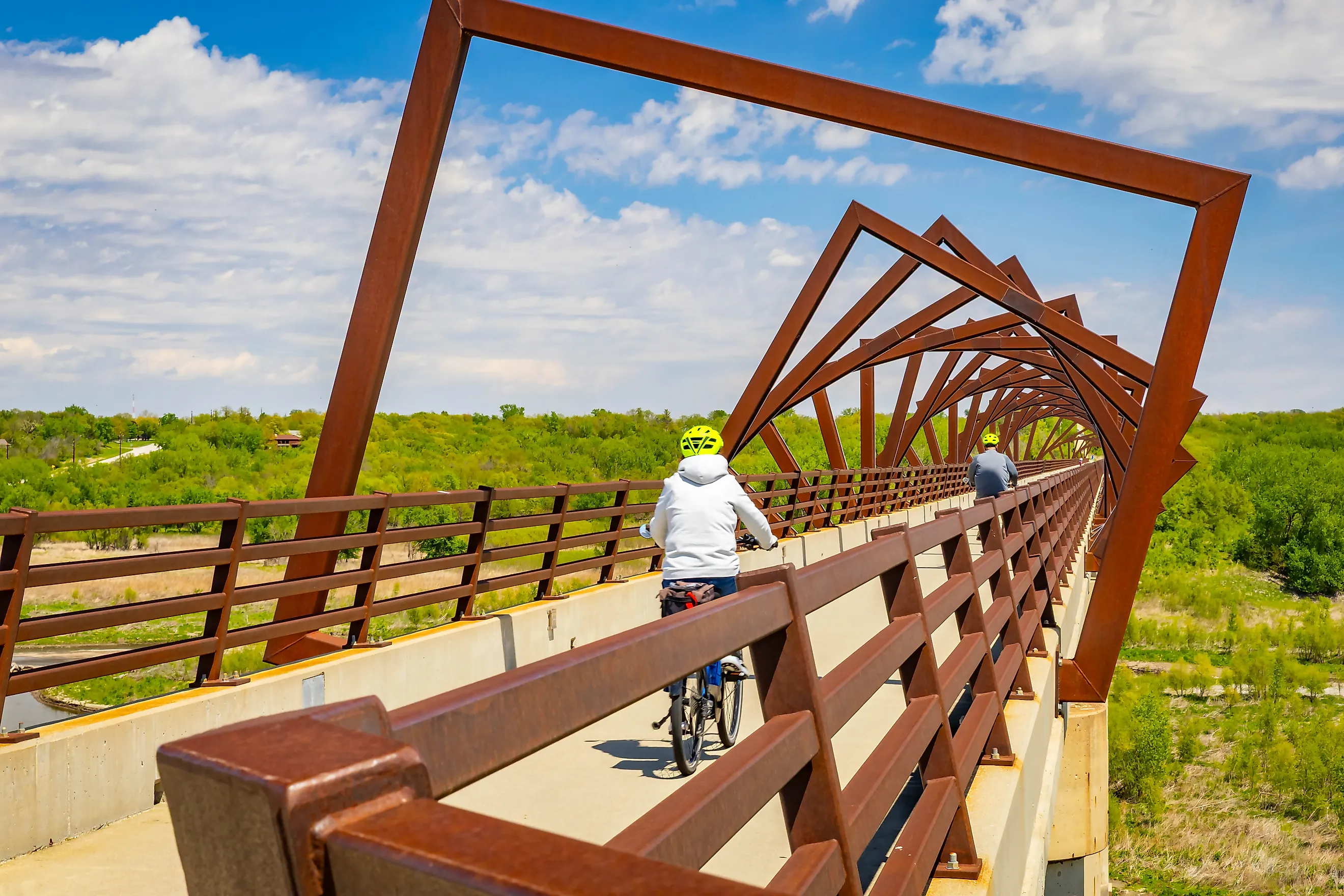
Measuring a half-mile (2,530 feet) and rising 130 feet over the Des Moines River Valley, the High Trestle Trail Bridge in Iowa is one of the largest trail bridges in the world. The bridge sits along the 25-mile High Trestle Trail, running through the Iowa towns of Ankeny, Sheldahl, Slater, Madrid, and Woodward. The concrete piers, or trestles, that support the bridge were originally built in the 1970s for a Milwaukee Road freight train line. When the line was retired, the concrete pillars left were nicknamed "Iowa's Stonehenge."
The modern trail bridge was constructed from 2009 to 2011, with engineers building a new pedestrian bridge deck directly atop the old pillars. Designed as a mine-shaft art installation by RDG Dahlquist Art Studio, the bridge features 41 geometric steel frames shaped to mimic the interior supports of a historic coal mine. Access to the trail and the bridge is free and always open. The bridge is lit from sunset to midnight from April through October and from sunset to 9 p.m. from November through March.
High Bridge, Virginia - 2,418 feet

High Bridge in Farmville, Virginia, rises 125 feet above the Appomattox River and runs for approximately 2,418 feet, making it Virginia's longest recreational bridge. Built in 1853 by the South Side Railroad, the railroad bridge was the site of the Civil War Battle of High Bridge in April 1865. Although it started as a wooden Howe truss structure atop masonry piers, it was rebuilt in 1914 with a steel plate girder viaduct that mirrors the original. Its original 1854 brick piers stand right next to it.
The Norfolk Southern Railway ran its last train across High Bridge in 2004. In 2006, the railroad donated 31 miles of the defunct rail line to the Commonwealth of Virginia for repurposing as a park. High Bridge Trail State Park was opened in sections, while the bridge underwent a structural rehabilitation to make it safe for pedestrians. On April 6, 2012, High Bridge reopened on the day of the 147th anniversary of the Battle of High Bridge. It is part of the 32.2-mile park. Those who walk or bicycle into the park can access the bridge for free. If you drive to the park, you must pay an admission fee. The bridge and park may be accessed from sunrise to dusk daily.
The Future of Walkable Engineering
These bridges are reserved specifically for foot and bicycle travel, helping to reduce carbon emissions and enabling pedestrians and bicyclists to travel miles between cities without interacting with vehicular traffic. Most have flat, ADA-compliant surfaces that accommodate strollers, wheelchairs, and runners. They help to foster active lifestyles and provide community spaces for events. As American urban planning trends continue to prioritize green spaces and alternative transit, the scale of pedestrian bridge projects will continue to grow.