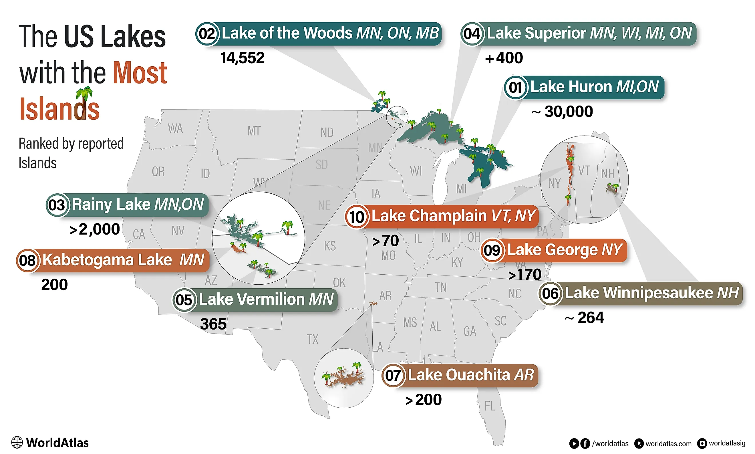
The US Lakes With the Most Islands
The United States is home to, and shares, some of North America’s most island-filled lakes. This list ranks lakes located at least partly in the U.S. by their total number of islands. In the case of border lakes, some of those islands lie in Canadian territory. Most of these island-filled lakes owe their shape to Pleistocene glaciation. Across the upper Midwest and Northeast, moving ice scoured bedrock basins and valleys; when the ice retreated, and the basins filled with water, higher ridges and rock knobs remained above the surface as islands. Farther south, Lake Ouachita formed differently: dam construction flooded a ridge-and-valley landscape, leaving former hilltops as islands. Lake Huron leads on this list by a wide margin, with roughly 30,000 islands, most of them in the Georgian Bay archipelago on the Canadian side. The lakes below are ordered by reported island totals, with the caveat that those totals carry wide error margins. Shoals, seasonal islets, and bare rocks are counted differently depending on the source.
Lake Huron (Michigan / Ontario)
Reported islands: about 30,000

Most of Lake Huron's 30,000 islands sit in Georgian Bay, the vast eastern arm that some call the sixth Great Lake. They form the largest freshwater archipelago on Earth, scattered in pink-granite clusters across the Ontario side of the border. The American share is smaller and gathers at the lake’s northern edge, where Drummond Island anchors a Michigan chain near the St. Marys River. The lake still carries the longest shoreline of any Great Lake, about 3,827 miles, once every inlet is traced.
The chain’s giant is Manitoulin Island, the largest lake island in the world at 1,068 square miles. Manitoulin has more than 100 inland lakes, and the largest of those, Lake Manitou, contains its own islands. The bedrock here is part of the Niagara Escarpment, the same dolomite arc that surfaces at Niagara Falls. Glaciers scraped much of it bare, leaving the smooth pink rock and wind-bent pines that draw painters and cottagers to the bay each summer.
Lake of the Woods (Minnesota / Ontario / Manitoba)
Reported islands: 14,552

French mapmakers called it Lac des Bois, and the 14,552 islands counted across Lake of the Woods explain the name. The lake sprawls more than 70 miles across the corner where Minnesota meets Ontario and Manitoba, so most of those islands rest in Canadian water. The American stake is the Northwest Angle, a wedge of land and islands that forms the northernmost point of the contiguous United States. It can be reached from the rest of Minnesota only by boat, by winter ice road, or by driving through Manitoba.
That odd boundary traces back to the 1783 Treaty of Paris, whose negotiators drew the line to the lake’s northwesternmost point based on imperfect maps of the region. Later treaties and survey crews settled the border, leaving the Angle stranded above the 49th parallel. Today, the tiny communities of Oak Island, Angle Inlet, and Penasse host a few hundred Americans. The lake drains north through the Winnipeg River toward Hudson Bay, the opposite direction from most of the country.
Rainy Lake (Minnesota / Ontario)
Reported islands: more than 2,000

More than 2,000 islands break the surface of Rainy Lake, which traces the Minnesota-Ontario border along the northern edge of Voyageurs National Park. Known in French as Lac La Pluie, the lake shares its name with Fort Lac la Pluie, a fur-trade depot near the Rainy River outlet into Lake of the Woods. For most of the 1700s and early 1800s, this was a continental highway. Crews paddling birch-bark North Canoes moved pelts between Lake Superior and the interior, resting on the lake’s islands before the long open-water crossings.
The Rainy Lake gold rush of the early 1890s left its mark on Little American Island. There, the Little American Mining Company sank shafts in search of ore and recovered only a few thousand dollars in gold. The diggings are still visible, now a short interpretive trail reachable by boat. Today, part of the lake sits inside a park explored mainly by water, where houseboats, walleye anglers, and winter ice roads have replaced the canoe brigades. The island-threaded channels look much as the voyageurs found them.
Lake Superior (Minnesota / Wisconsin / Michigan / Ontario)
Reported islands: several hundred

No single agency keeps a clean tally of Lake Superior's islands. Still, credible estimates usually put the number at more than 400, with higher counts possible when shoals and care rocks are included. The lake is the largest body of fresh water on Earth by surface area. Its islands lie in waters shared by Michigan, Wisconsin, Minnesota, and Ontario. The American side holds the headliners. Isle Royale, a wilderness national park, is the largest island in the lake, ringed by more than 450 smaller islands of its own.
Off Wisconsin’s Bayfield Peninsula, the 22-island Apostle Islands archipelago draws kayakers to red sandstone sea caves, while Madeline Island keeps the chain’s only year-round village. Minnesota’s North Shore adds the 13 rugged Susie Islands near the Canadian line. The Ontario side contributes its own giants, among them Michipicoten Island and the Slate Islands, an unlikely refuge for woodland caribou. Ancient sandstone, volcanic ridges, and Precambrian bedrock give many of Superior’s islands the cliffs, cobble beaches, and dark forests that make them among the most dramatic on the continent.
Lake Vermilion (Minnesota)
Reported islands: 365

Of the lakes near the top of this list, Lake Vermilion is the rare one that lies entirely inside the United States. All 365 of its islands sit in northeastern Minnesota. The Ojibwe knew it by a name describing how a low sun reddened the water, and French traders rendered it as vermilion, a red pigment. The lake stretches about 40 miles through the Arrowhead region between the towns of Tower and Cook, and its forested islands and crooked shoreline have made it one of Minnesota’s most popular vacation lakes.
For two centuries, the lake was a link in the fur-trade route running from Lake Superior toward the interior. French fur traders were using the lake by the 1670s. A brief gold rush followed an 1865 survey, but the prospectors found little, and the real wealth turned out to be iron. The Soudan Mine at the lake’s eastern end became Minnesota’s first iron mine and now anchors a state park. Vermilion has since turned almost entirely from ore to recreation.
Lake Winnipesaukee (New Hampshire)
Reported islands: about 264

Between the foothills of the White Mountains and the Belknap Range in central New Hampshire, Lake Winnipesaukee spreads across 71 square miles. The lake formed during the last glacial retreat, leaving an oligotrophic basin scattered with granite islands and ledges left by the ice sheet. Cartographic counts run from about 253 to 274, depending on which boats and rocks qualify as islands, with the widely-cited Bizer Corporation tally landing at 264. About 130 of those islands cover more than a quarter-acre, the practical threshold for a building site.
The lake’s named islands include Long Island, the largest at over a thousand acres; Bear Island; Cow Island; Rattlesnake Island; and Diamond Island. The MV Sophie C, a US mail boat that has run the route since 1969, delivers letters and packages to eight of the islands during the summer season. It is one of only two operating floating United States Postal Service post offices, and Lake Winnipesaukee’s mailboat service dates back to 1892. Wolfeboro on the eastern shore calls itself the oldest summer resort in America. The Broads, a wide island-free stretch of open water at the lake’s center, separates the western bays from the cottage-lined eastern coves.
Lake Ouachita (Arkansas)
Reported islands: more than 200

Unlike the glacially carved lakes farther north, Lake Ouachita is a reservoir. It stretches 36 miles through west-central Arkansas and lies entirely within the Ouachita National Forest. The US Army Corps of Engineers completed the 231-foot Blakely Mountain Dam on the Ouachita River in 1953. The flooding submerged a forested ridge-and-valley landscape, and the higher ridge tops became more than 200 islands across the resulting 40,000-acre basin. The Forest Service buffer prevents shoreline development, so almost all the islands stay uninhabited.
Bird Island, in the lake’s eastern reach, hosts a fall roost of 10,000 to 40,000 purple martins so dense that NEXRAD radar picks up the swarm. Crystal Island gets its name from the milky quartz veins that surface across its rocks. The Mount Ida area west of the lake is the country’s largest source of clear quartz crystal. Underwater, divers visit a submerged forest of standing trees and the ruins of the flooded town of Buckville. In Lake Ouachita’s notably clean water, rare freshwater jellyfish can also sometimes be spotted. Lake Ouachita State Park, on the eastern shore, hosts the principal boat tours and ranger-led programs.
Kabetogama Lake, Voyageurs National Park (Minnesota)
Reported islands: 200

The name Kabetogama is Ojibwe for “the lake that lies parallel,” a reference to its position alongside Rainy Lake to the north. The lake itself runs 15 miles along the southern boundary of Voyageurs National Park, in northern Minnesota near the Canadian border. The basin rests on Canadian Shield bedrock more than 2.5 billion years old, and the National Park Service counts 200 islands across its 25,760 acres. The shoreline runs jagged for 78 miles, with hundreds of small bays and channels separating one island cluster from the next.
Voyageurs ranks among the few US national parks accessible primarily by water; the Kabetogama Peninsula at the park’s heart has no roads. The park was named after the French-Canadian fur traders who used the region’s interconnected lakes and rivers as a continental interior trade route in the 1700s. In 2020, the park was designated an International Dark Sky Park, recognizing its low light pollution. It is one of the better aurora-viewing destinations in the lower 48 states. Ellsworth Rock Gardens, a hand-built sculpture site on the Kabetogama Peninsula’s north shore, draws park visitors who arrive by boat from the Kabetogama Lake Visitor Center.
Lake George (New York)
Reported islands: more than 170

A glacial trough between the Tongue Mountain Range to the west and Black Mountain to the east, Lake George reaches 32 miles through the southern Adirondacks of New York. The lake formed about 10,000 years ago and drains into Lake Champlain through the short La Chute River. More than 170 islands punctuate the surface, ranging from the car-sized Skipper’s Jib to large landmasses like Long Island and Vicar’s Island. The Narrows, a five-mile island-filled passage in the lake’s middle reach, holds the densest cluster.
Thomas Jefferson called Lake George “the most beautiful water I ever saw” in 1791 after a tour of the region with James Madison. The nickname Queen of American Lakes followed soon after. Long before that, the lake was a flashpoint of the French and Indian War. The 1755 Battle of Lake George and the 1757 fall of Fort William Henry were both fought along its southern end. Today, 148 of the islands belong to New York State, and 44 of them hold a total of 387 boat-in campsites managed by the Department of Environmental Conservation. The Jefferson Project, a sensor-based water-quality study run jointly by IBM and Rensselaer Polytechnic Institute, has been monitoring the lake continuously since 2014.
Lake Champlain (Vermont and New York)
Reported islands: more than 70

Between Vermont's Green Mountains and New York’s Adirondacks, Lake Champlain fills a 200-million-year-old graben valley for 120 miles, with its northern tip in Quebec. Pleistocene glaciation reshaped the basin, and the ice retreat briefly opened the lowland to Atlantic seawater, which formed the short-lived Champlain Sea. The Lake Champlain Basin Program counts more than 70 islands across the lake’s 435 square miles of surface water and 587 miles of shoreline.
Most of the islands cluster in the lake’s northern reach. The Hero chain (Grand Isle, North Hero, South Hero, and Isle La Motte) gives Vermont’s Grand Isle County its name. Causeways and bridges along US Route 2 connect the chain to the mainland on both ends. Valcour Island, off the New York shore near Plattsburgh, holds the Bluff Point Lighthouse and a state forest preserve. On October 11, 1776, Benedict Arnold’s Continental fleet engaged a British force in the channel west of the island, the first naval battle between American and British navies. Lake Champlain supplies drinking water to about 200,000 people in Vermont, New York, and Quebec.
Why the Counts Vary
Across these ten lakes, the reported island counts run from about 70 to roughly 30,000. The spread comes mostly from definitional choices about shoals, seasonal islets, and rocks that barely clear the surface, and from where an international border happens to fall. What stays constant is the underlying geography. Glacial scraping or reservoir flooding broke these basins into ridges and channels, and wherever a ridge stood high enough above the water, an island appeared. The exact totals will keep shifting, but the pattern holds.