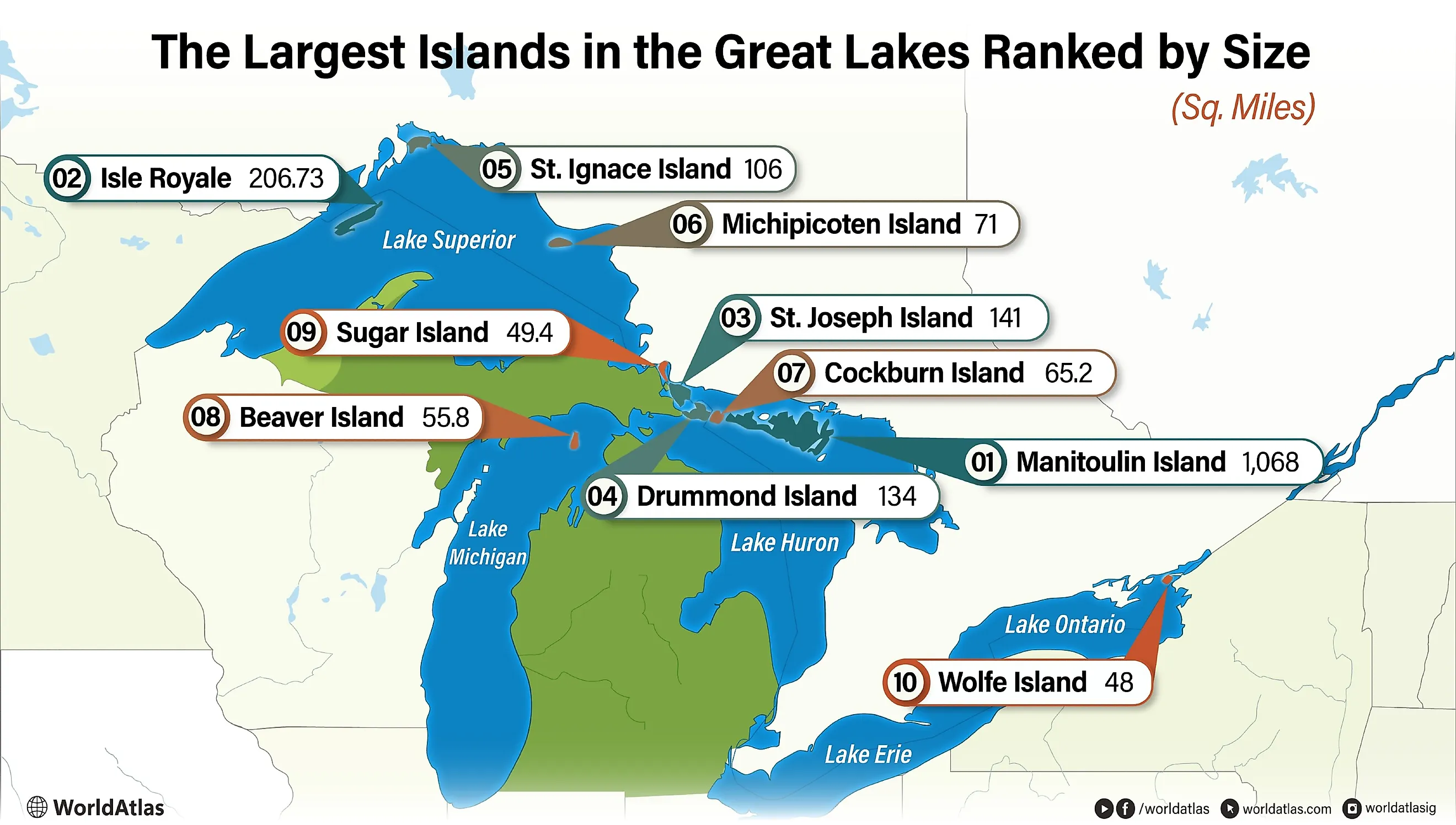
The Largest Islands in the Great Lakes Ranked by Size
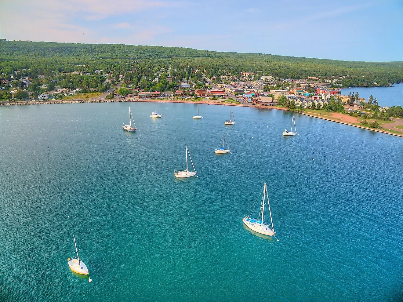
About 35,000 islands sit in the waters of the Great Lakes. They range from rocks barely big enough to land a kayak on to permanent communities with their own ferry schedules. The largest, Manitoulin Island in northern Lake Huron, is the largest freshwater lake island in the world. It could fit the city of San Antonio twice over and still have room to spare. The ten below are the heavyweights of the system.
10 Largest Islands in the Great Lakes Ranked by Size
| Rank | Island | Area (sq. miles) |
|---|---|---|
| 1 | Manitoulin Island | 1,068 |
| 2 | Isle Royale | 206.73 |
| 3 | St. Joseph Island | 141 |
| 4 | Drummond Island | 134 |
| 5 | St. Ignace Island | 106 |
| 6 | Michipicoten Island | 71 |
| 7 | Cockburn Island | 65.2 |
| 8 | Beaver Island | 55.8 |
| 9 | Sugar Island | 49.4 |
| 10 | Wolfe Island | 48 |
1. Manitoulin Island (1,068 mi2)

Manitoulin Island at 1,068 mi2 (2,766 km2) is also the largest freshwater lake island in the world. It holds two incorporated towns, eight townships, and six Anishinaabe communities, with a permanent population of 12,600. CBC has reported that the population grows by more than a quarter during the summer tourist season.

The island contains 108 of its own lakes, supporting boating, paddling, and fishing without ever leaving its shoreline. Low Island Park in NEMI (North Eastern Manitoulin and the Islands) is the largest of the town's six parks, with a beach, splash pad, skate park, two baseball diamonds, and a walking trail. Manitoulin was a finalist for the Seven Wonders of Canada nomination, though it didn't make the final list.
2. Isle Royale (206.73 mi2)

At 206.73 mi2 (535.4 km2), Isle Royale is about a fifth the size of Manitoulin and the second-largest island in the Great Lakes. It anchors Michigan's Isle Royale National Park, one of more than 400 islands inside the park, just south of Thunder Bay, Ontario, on Lake Superior.

The park rules are built around keeping the place wild. Pets are banned, motors aren't allowed on boats in the interior lakes (there are at least eight), and amenities are limited. Perch and pike are the main quarry for anglers willing to portage in. A handful of campsites, two outfitter stores, and a couple of restaurants make up the supporting infrastructure.
Several preserved shipwrecks rest in the surrounding waters, drawing scuba divers each season. Above water or below, Isle Royale is set up for visitors who want a wilderness experience without infrastructure smoothing it out for them.
3. St. Joseph Island (141 mi2)

The second-largest island on Lake Huron at 141 mi2 (365 km2), St. Joseph Island is the third-largest of all the Great Lakes islands. About 2,300 people live on it across the townships of Jocelyn and Hilton plus the village of Hilton Beach.
Where Isle Royale has a handful of interior lakes, St. Joseph has nearly 60. The combination of climate and stands of maple trees around those lakes makes it the epicenter of maple syrup production in Ontario, accounting for roughly 18 percent of the province's output.
The island also matters as a conservation site. In 2026, Two Tree River was designated a Key Biodiversity Area for hosting Canada's northernmost population of redside dace, a small minnow notable for being the only fish in Canada that leaps out of the water to catch flying insects. Decades earlier, in 1951, the Canadian Wildlife Service set aside 940 hectares as the St. Joseph Island Migratory Bird Sanctuary, which still draws birdwatchers each migration season.
4. Drummond Island (134 mi2)

Drummond Island is the fourth-largest of the Great Lakes islands at 134 mi2 (350 km2), the third-largest in Lake Huron, and the fifth-largest island in the contiguous United States. Drummond Township covers the main island plus several smaller surrounding islands and includes the four unincorporated communities of Maxton, Lincoln, Johnswood, and Drummond, with a combined population of about 1,000.
The recreation calendar runs year-round. Hiking, biking, fishing, and boating fill warm months. Snowmobiling, skating, and skiing take over in winter. Off-road trail networks operate in the shoulder seasons. Drummond Island Resort handles the indoor side of things, with skeet shooting, a golf course, cabin and camp accommodations, and several dining options.
5. St. Ignace Island (106 mi2)
Not to be confused with the city of St. Ignace on Michigan's Upper Peninsula, St. Ignace Island sits at the entrance to Nipigon Bay on Lake Superior. At 106 mi2 (274 km2) it is the fifth-largest of the Great Lakes islands and the second-largest in Lake Superior after Isle Royale.
The island is uninhabited. It contains two main lakes, no roads, no campgrounds, and no safety personnel. The viable travel window runs roughly June to September. Anyone going needs to bring everything in and out themselves.
The main draw is Mount Saint Ignace, rising from the eastern shores of King Lake to 1,854 ft (565 m). It is the highest point of any island in Lake Superior. The hike is roughly 11 km round trip, gaining 386 m in elevation, and most parties take five to six hours to complete it. Guided sea kayak trips out of Rossport are the standard way in.
6. Michipicoten Island (71 mi2)

Michipicoten Island covers 71 mi2 (184 km2), making it the sixth-largest of the Great Lakes islands. Local First Nations historically called it the "Floating Island" because of a mirage effect that lifts it off the horizon on clear days when seen from Lake Superior's shore. Per NaturallySuperior.com, they shunned it as the home of malevolent giants. That history did not prevent later attempts at copper mining, all of which closed long ago, or the eventual establishment of a provincial park. Ontario Parks has managed the island since 1985.
The park designation comes with very little infrastructure. Ontario Parks does not advertise camping sites and only points fishers toward the surrounding waters. Naturally Superior Adventures in Wawa runs fly-and-boat trips and seven-day sea-kayak expeditions for experienced paddlers. Some commercial fishing and a handful of private camps still operate. Beyond that, Michipicoten Island is mainly a destination for paddlers and campers who want to handle everything themselves.
7. Cockburn Island (65.2 mi2)

Cockburn Island sits between Drummond and Manitoulin at the north end of Lake Huron, covering 65.2 mi2 (168.9 km2). Statistics Canada lists 16 permanent residents and publishes nothing further about the population. There is no ferry service. Visitors arrive in their own boats or coordinate ahead with an island resident, and they must bring their own provisions. Per Cockburn Island Township, "there are no camping or tenting sites on the island."
8. Beaver Island (55.8 mi2)

Beaver Island has about 600 permanent residents and an area of 55.8 mi2 (145 km2), making it the largest island on Lake Michigan and the eighth-largest across the Great Lakes.
The infrastructure is sized for visitors but anchored to the local community. Ferry service and two flight services connect to the mainland. Emergency services, grocery stores, restaurants, convenience stores, and equipment rentals all operate year-round.
Some of Beaver Island and several of its 14 neighbors in the Beaver Island Archipelago are protected under the Beaver Island State Wildlife Research Area, but the rest stays open for exploration. Notable features include ancient stone circles set by Indigenous communities centuries ago and 19th-century shipwrecks lying just offshore.
9. Sugar Island (49.4 mi2)

Sugar Island sits between the St. Marys River system, Lake Nicolet, and Lake Huron, covering 49.4 mi2 (128 km2) and ranking ninth among Great Lakes islands. About 700 people live there year-round, with the population climbing through summer. Ferry service connects it to the mainland.
Both the Bay Mills Indian Community and the Sault Tribe of Chippewa Indians hold land on the island. Tourists move through year-round regardless. Timber Ridge Resort sits at the south end, drawing visitors who specifically want a quiet stay with water views.
10. Wolfe Island (48 mi2)

Wolfe Island is the largest of the Thousand Islands on Lake Ontario at 48 mi2 (124 km2), making it the tenth-largest island in the Great Lakes. It sits between Kingston, Ontario, and Cape Vincent, New York, with year-round ferries running from both the Canadian and American sides.
The island is part of Frontenac Islands Township and has about 1,400 year-round residents, with a summer population that climbs higher. Most live in or around Marysville, the village settlement on the island's north shore. The settlement supports a steady set of restaurants, bakeries, and shops that serve both locals and visitors year-round.
Wolfe Island is also home to one of Ontario's larger wind farms, with 86 turbines spread across its farmland and shoreline. The combination of working fields, ferry traffic, and lake access keeps the island lived-in rather than seasonal, setting it apart from many of the smaller Thousand Islands nearby.
The Other 34,990
These ten islands hold most of the year-round population and infrastructure across the Great Lakes system. The other 34,990 are mostly small, often uninhabited, and many have no permanent road or ferry service. The ten above are the ones with enough scale to support towns, working ferry routes, and trail networks substantial enough to plan a multi-day trip around.