The Canadian Lakes With the Most Islands
Canada has the most lakes of any country, and many of them carry more islands than they do clear stretches of open water. Glacial scraping during the last ice age gouged out deep depressions across the Canadian Shield, leaving the higher ridges of resistant rock as islands above the meltwater that filled the basins. Georgian Bay (part of Lake Huron) holds the most, by a long way, with a stretch of shoreline known as the Thirty Thousand Islands. Lake of the Woods, on the Ontario-Manitoba-Minnesota corner, comes next at around 14,500. Pinning down exact counts is notoriously difficult: estimates from government and conservation bodies often differ by an order of magnitude depending on whether tiny shoals and partially submerged outcrops are included. The lakes below are ordered by reported island totals, with the caveat that those reported totals come with wide error bars.
1. Georgian Bay (Lake Huron)

Estimated islands: 30,000+
Georgian Bay forms the northeastern part of Lake Huron, with the Bruce Peninsula splitting it from the rest of the lake. Stretching from Parry Sound up to Killarney, the bay's eastern shore is the Thirty Thousand Islands, the world's largest freshwater archipelago. The Canadian Shield bedrock here runs in pink granite ridges that poke above the water's surface, and many of the smaller islands hold so little soil that they support only wind-bent pine. Inside the lake, Manitoulin Island covers 1,068 square miles (2,766 km²) and is the world's largest freshwater island.
Boaters running between Parry Sound and Killarney use the Small Craft Route, a marked passage along the protected eastern shore that threads through Byng Inlet, Sans Souci, and dozens of similar bays around rocky shoals just below the surface. Beausoleil Island, in Georgian Bay Islands National Park, and Philip Edward Island, near Killarney, are two of the better-known stops along the way.
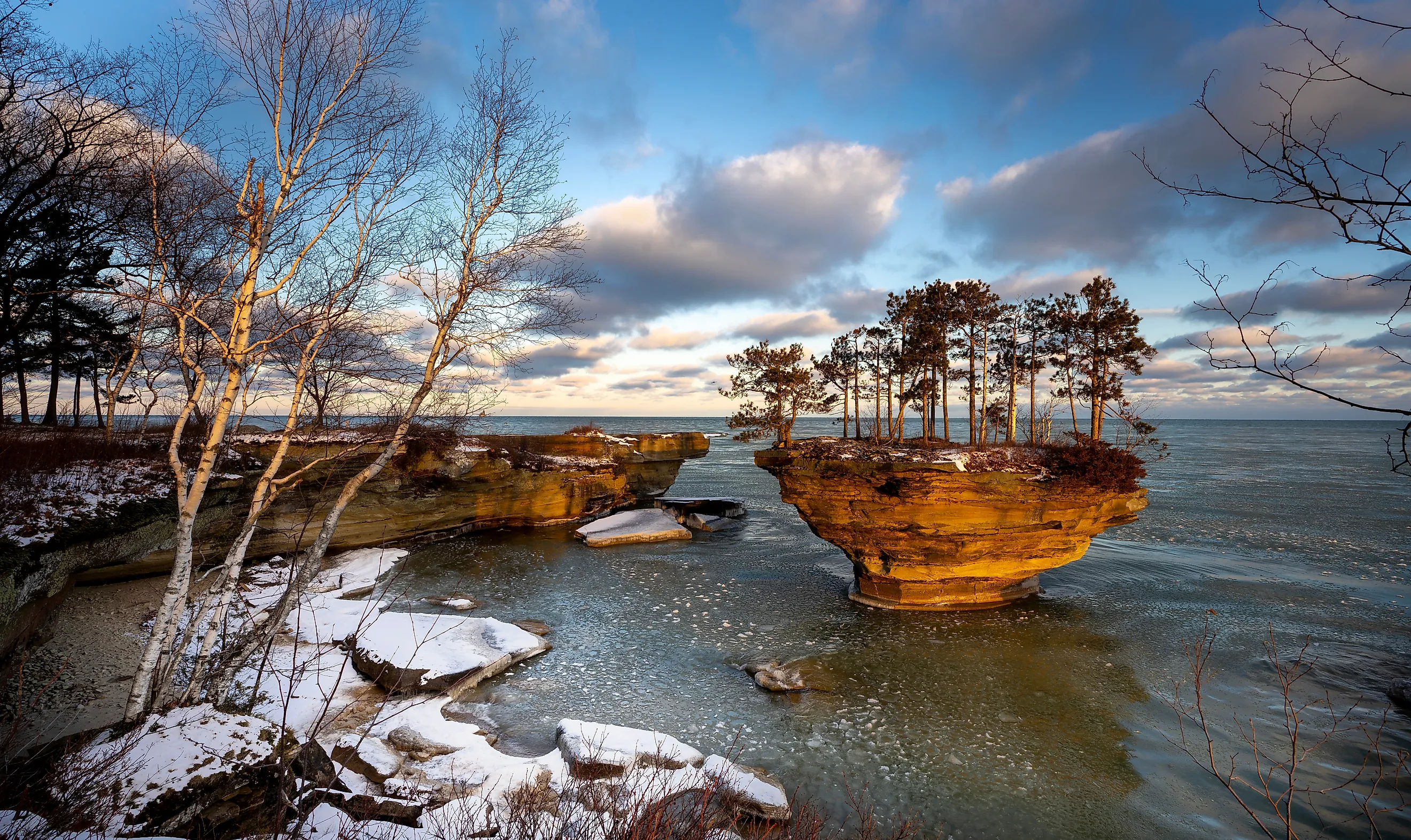
2. Lake of the Woods

Estimated islands: ~14,500
Lake of the Woods runs through northwestern Ontario near Kenora and reaches into southeastern Manitoba and northern Minnesota at its southern end. The basin was scraped flat by glaciers and left with around 14,500 islands across a network of tight passages and bays. Big Narrows, a constriction in the southern reach where depth changes draw walleye and muskie, is one of the standard fishing spots.
Past the marked buoy routes, the lake holds plenty of hazards: hidden granite shelves near Sioux Narrows and Devil's Gap can sit just under the surface waiting for an unsuspecting prop. The Northwest Angle, a small American exclave reachable only by crossing through Canadian waters or driving through Manitoba, draws boaters seeking solitude (a border check-in is required either way).
3. Reindeer Lake

Estimated islands: ~5,500
Reindeer Lake straddles the Saskatchewan-Manitoba border in the northern Canadian Shield, in a fractured basin shaped by glacial ice that scraped massive quantities of rock out of the underlying granite. At the southern end of the lake, Deep Bay sits in a strikingly circular depression about 8 miles wide and 720 feet deep, the result of a meteorite impact dated to about 99 million years ago in the Cretaceous. The bay is the deepest body of water in Saskatchewan, and the water often runs clear enough near the steep sides to see down dozens of feet.
Across the rest of Reindeer Lake, an estimated 5,500 islands rise from the water. Boundary Island sits on the Manitoba-Saskatchewan border. Amiskit Island and dozens of smaller islets cluster along the Manitoba shore near Kinoosao, where narrow channels between rock ridges concentrate lake trout and northern pike along underwater drop-offs.
4. Rainy Lake

Rainy Lake in Voyageurs National Park.
Estimated Islands: 500 to over 2,000
Rainy Lake straddles the Ontario-Minnesota border, and the island count varies widely depending on who is doing the counting. Some sources put the total near 500. Others claim more than 2,000 on the Canadian side alone. The discrepancy is a textbook case of definitional difficulty: small rocky outcrops, seasonal islets, and partially submerged shoals all sit in a gray zone. Most of the islands are on the Canadian side. The bedrock is part of the Superior Craton, with rock dated between 2.5 and 3.6 billion years old, some of the oldest exposed surface on Earth.
Boaters running the North Arm work through a dense, rocky labyrinth that is hard on propellers. The lake also held strategic importance during the fur trade, when French-Canadian voyageurs used the narrow channels among the islands as a primary east-west route. Today, the American shore within Voyageurs National Park is fully protected, while the Canadian side runs as a patchwork of Crown land, conservation zones, and private cabin lots.
5. Lac La Ronge

Estimated islands: ~1,305
Lac La Ronge sits in the north-central Saskatchewan Shield, in a broken basin where land and water blend together across nearly 1,300 islands in a relatively limited footprint. The shoreline is jagged and uneven, with channels between islands sometimes shrinking to just a couple of hundred feet, especially in the main basin west of the town of La Ronge. The lake links to Nemeiben Lake through a narrow channel system, and the two share similar island patterns and shorelines.
Highway 2 runs into La Ronge from the south, and public boat launches give access to the western edge and most of the island clusters. Each summer, the town runs fishing tournaments that draw anglers chasing northern pike and walleye. The Grandmother's Bay Fish Derby in March is the local ice-fishing event.
6. Lake Temagami

A group of young men paddling through a lake in Temagami, Ontario. Image credit: Cavan-Images / Shutterstock.com.
Estimated islands: ~1,250
Lake Temagami in northeastern Ontario was carved out when glaciers fractured the bedrock into ridges and basins that later filled with meltwater. Today, more than 1,200 islands divide the lake along long arms like the Northeast Arm and the Hub. Some of the islands hold stands of old red and white pine more than 300 years old.
The system links to Obabika Lake and Lady Evelyn Lake, both also packed with islands. Canoe routes from Temagami town reach into the lake itself and continue into Obabika, where backcountry campsites sit on points framed by old-growth pine. The White Bear Forest trail network, just outside town, runs through a stand of red pine with views over the island-packed arms below.
7. Great Slave Lake

Estimated Islands: 1,000+
The deepest lake in North America, Great Slave Lake in the Northwest Territories reaches 614 meters (2,014 feet) at its deepest point and holds more than 1,000 islands, mostly in its North and East Arms. The North Arm is locally said to hold "a million islands," a rough way of describing the high density of small rocky outcroppings.
The reason no official count exists is that the lake's island-like features range from rugged Precambrian outcrops to low-lying shoals that get partly submerged when water levels rise. Many of the smaller landmasses are exposed Shield fragments, and whether they count as islands depends on where the surveyor draws the line. The East Arm holds the lake's most striking scenery, with archipelagos backed by steep cliffs, and is now protected within Thaidene Nene National Park Reserve.
8. Lake Abitibi

Estimated Islands: 900+
Lake Abitibi straddles the boundary of northeastern Ontario and western Quebec, a shallow basin made up of two main pools connected by a narrows, with a total surface area of 360 square miles (932 km²). The basin sits in the Clay Belt region, a flat band of glacial-lake sediment that runs across northern Ontario and Quebec, and many of the islands are low-lying glacial deposits over bedrock.
Official Ontario provincial data identifies at least 786 islands on the Ontario side alone, protected within Lake Abitibi Islands Provincial Park. The islands range from larger named landmasses like Deer, Dominion, and St. Patrick to tiny unnamed shoals. The patchwork supports nesting bald eagles and great blue herons, and the underwater shoals around the islands draw walleye in significant numbers.
9. Lake Nipigon

Estimated islands: 500+
Lake Nipigon, about 60 miles northeast of Thunder Bay, drains into Lake Superior through the Nipigon River. More than 500 islands rise across a basin shaped by Precambrian Shield bedrock and overlying sedimentary formations, especially around Orient Bay and the Black Sturgeon area. The lake holds the world record for brook trout, a 14.5-pound fish caught in the Nipigon River in 1915 that has stood for over a century.
The town of Nipigon serves as the central access point, with Highway 11 running up from town to the lake's southern edge. Public boat launches near Orient Bay open onto the closer island groups, where drop-offs and underwater ledges define both the navigation and the fishing. The northern reaches toward Ombabika Bay run far less trafficked than the south end.
In Conclusion
These nine lakes show the imprint of glaciation on the Canadian Shield as well as anywhere in the country. Each one fills a fractured basin with thousands of islands, and the precise counts depend on where individual surveyors draw the line between "island" and "submerged rock." What stays constant is the look of the place: huge, broken-up basins where land and water wrap around each other in arrangements that genuinely qualify as some of the most island-packed freshwater on the planet.


