The Most Endangered Lakes in the World
Lakes around the world are increasingly threatened by several factors, such as human activity, climate change, and the diversion of inflowing rivers. These environmental pressures can devastate ecosystems, damage economies reliant on fishing, and increase adverse health conditions among local communities.
The following lakes are among the world’s most endangered, selected primarily for the dramatic decline in their surface area over time. A lake is considered endangered when its water volume, chemistry, biodiversity, or long-term ecological stability is severely threatened. This differs from a functionally extinct lake, in which the entire body of water disappears, leaving the lakebed permanently dry.
In some cases, such as Lake Poopó, the lake dried up almost completely in 2015, only partially regaining water during the rainy season. Other lakes, like Lake Urmia, were once among the largest in their regions but have since lost around 90 percent of their total surface area.
Aral Sea

The Aral Sea is the world’s former fourth-largest inland body of water. It is situated in Central Asia, on the border between southern Kazakhstan and northern Uzbekistan. Aral Sea’s primary source of inflowing water is from the Syr Darya and the Amu Darya Rivers. Prior to the 1960s, water levels remained stable because inflows from both rivers balanced water loss through evaporation. In 1960, before its modern decline, the Aral Sea had a surface area of about 26,300 square miles (68,000 square kilometers).

In 1960, the Soviet Union diverted the Syr Darya and the Amu Darya Rivers into the desert region in Uzbekistan, Kazakhstan, Turkmenistan, and elsewhere in Central Asia to irrigate farmlands. By 1989, the Aral Sea had split into two sections: the “Greater Sea” in the south and the “Lesser Sea” in the north, further fragmenting into three separate lakes by the end of the 20th century, when the Greater Sea separated into a long, narrow western lake and a broader, eastern lake. The World Bank-supported Kok-Aral Dam helped restore parts of the North/Lesser Aral Sea, but the South/Greater Aral Sea has continued to shrink, with its eastern basin periodically drying out. Today, the lake has decreased to ten percent of its original area, currently at 1,300 square miles (3,500 square kilometers). As a result, desertification has taken place around the sea, forming the Aralkum Desert.
When wind blows across the seabed, a toxic dust contaminated with salt creates health problems for the area’s inhabitants. There are unusually high rates of throat cancer, anemia, kidney disease, and infant mortality in the region.
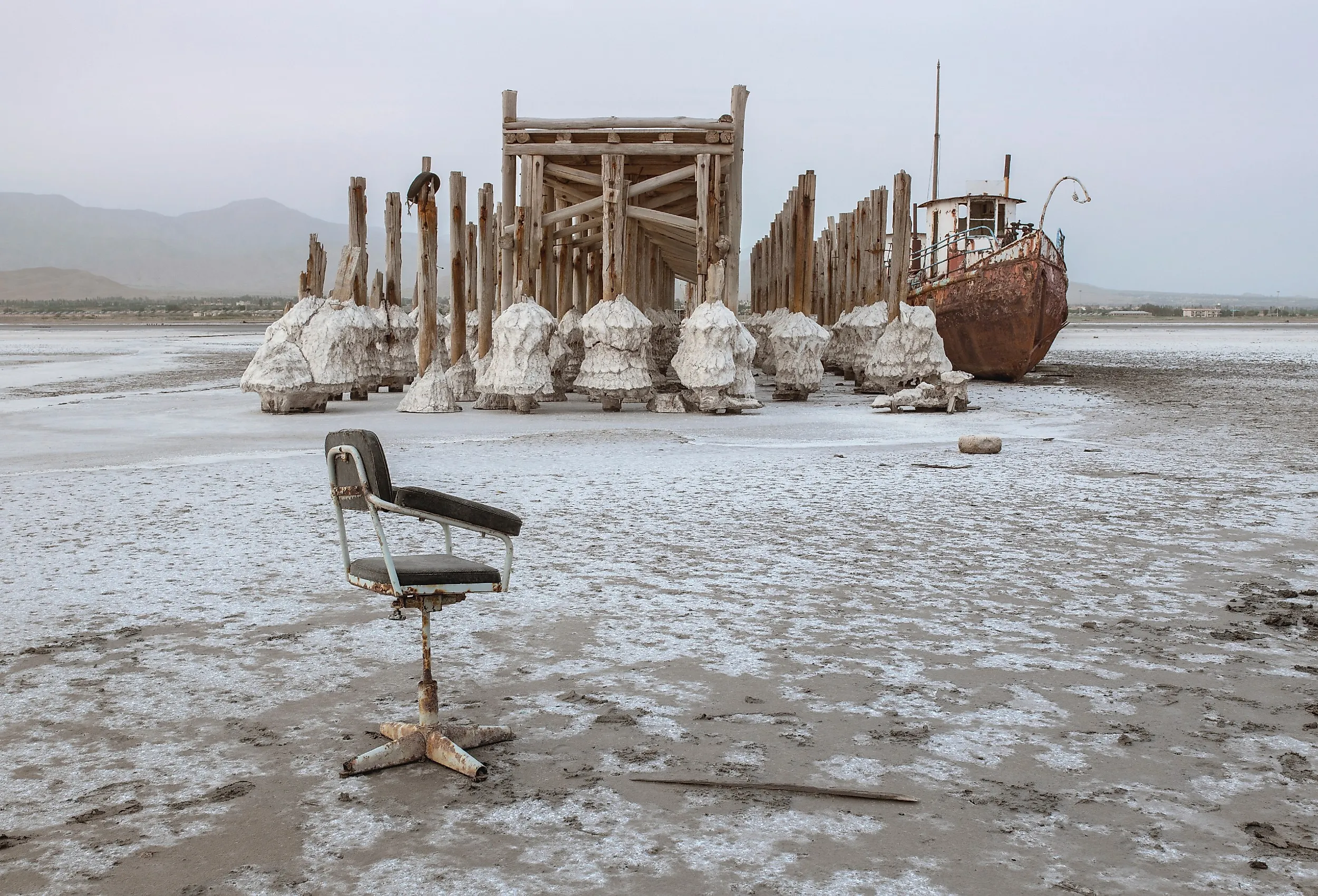
Lake Urmia

At its greatest extent, Lake Urmia was the largest lake in the Middle East, with a surface area of roughly 2,000 square miles (5,200 to 6,000 square kilometers), but by autumn 2023, much of it had transformed into a dry salt flat. Located in northwest Iran, the lake measures 87 miles (140 kilometers) long, between 25 and 35 miles (40 to 55 kilometers) wide, and 53 feet (16 meters) at its deepest point. Lake Urmia is primarily fed by the Talkheh River in the northeast, and the Zarīneh and Sīmīneh Rivers in the south. Lake Urmia’s waters are highly saline as it has no outlets. Salt content varies from 8 to 11 percent in the spring and 26 to 28 percent in late autumn.
In 1995, Lake Urmia reached a high-water mark, holding roughly 32 billion cubic meters of water. However, in the following two decades, the lake level dropped over 23 feet (7 meters), consequently losing around 90 percent of its total surface area. By August 2025, Lake Urmia's surface area had shrunk to 224 square miles (581 square kilometers). This can be attributed to consecutive droughts, agricultural water use, and dam construction on its three major inflowing rivers. The drying up of the lake has had a negative impact on the resident brine shrimp population. The loss of water is affecting the salinity of the lake, which in turn is threatening the survival of brine shrimp. Without these shrimp to feed on, Lake Urmia is experiencing a loss in its migratory bird populations, thus affecting the entire ecosystem’s sustainability.
Lake Poopó

Lake Poopó is located in the Altiplano Mountains of west-central Bolivia, and was once the country's second-largest lake. Historically, it covered 977 square miles (2,530 square kilometers), measuring 56 miles (90 kilometers) long, 20 miles (32 kilometers) wide, and only 8 to 10 feet (2.4 to 3 meters) deep. The lake was primarily fed by the Desaguadero and Márquez Rivers, with its only outlet being the Lacajahuira River. Historically, Lake Poopó has had a surface area close to 3,000 square kilometers (1,200 square miles). However, its surface area began to decline in the mid-1990s to the point that it is rarely deeper than 3 meters (9 feet).
The lake’s decline has been linked to climate variability and warming, reduced inflows, sediment and pollution from mining, and water withdrawals for irrigation and agriculture. In the mid-1990s, an extensive drought caused the disappearance of the lake; the water lost was replenished by a renewed rain cycle and flow from the Desaguadero and Márquez Rivers. Over the next two decades, rising temperatures as a result of global warming in the region tripled the evaporation rate of Lake Poopó. The regular occurrence of El Niño caused an abundance of rainfall in some regions of Bolivia, while producing drought in other areas, such as Lake Poopó. Mining activities dating back to 1981 from 120 lead, tin, and gold mines resulted in the discharge of waste directly into Lake Poopó’s waters.

The amalgamation of global warming, extended periods of drought, and sediment buildup by the local mining industry culminated in the total drying up of the lake in December 2015. This caused huge economic consequences for the people who relied on fishing from the lake to make a living, forcing many to relocate. While the lake managed to recover some of its flow during the rainy season, the situation surrounding it remains a concern during dry months.
Lake Chad

Lake Chad was at one point in time considered one of the largest lakes in Africa, with shorelines in Chad, Cameroon, Nigeria, and Niger. While Lake Chad’s surface area fluctuates significantly with the seasons, at 920 feet (280 meters) above sea level, it once covered about 6,875 square miles (17,800 square kilometers). This was in the 1960s. At the turn of the 21st century, the area typically averaged 580 square miles (1,500 square kilometers), less than a tenth of the area it once covered. Lake Chad is primarily fed by the Chari-Logone River system, with remaining inflow stemming from the Ebeji and Yedseram Rivers.
Lake Chad provides fresh water for over 30 million people; intense dry seasons between November and March have had an adverse effect on the water supply. Throughout the 1970s, severe droughts caused water to disappear from the northern basin, causing the lake to separate into two lobes. Since the 1970s droughts, Lake Chad has often functioned as northern and southern pools separated by the Great Barrier; the northern pool is irregularly flooded and can remain dry when inflow is insufficient. The dry season also causes periods of the harmattan, a dry wind that blows in from the Sahara Desert. Through increased isolation, reduced humidity, and desiccating winds, the water level in the lake is greatly reduced.
Dead Sea

The Dead Sea is a landlocked salt lake between Jordan to the east, and the West Bank and Israel to the west. The West Bank lies on the northern half of its western shore, while Israel lies on the southern half of its western shore. The Jordan River flows into the Dead Sea from the north, historically supplying it with nearly all of its water. The Dead Sea's shores are the lowest exposed land elevation on Earth, and its water surface is now more than 430 meters below sea level. The Dead Sea’s name originates from its high salinity, which both keeps bathers buoyant and inhibits the growth of plants, as well as the survival of fish and other wildlife.
During hot summers, the water level can drop as much as one inch because of evaporation. However, the water level of the Dead Sea is rapidly dropping. Up until the 1950s, the flow of fresh water into the Dead Sea equaled the rate of evaporation. But, in the 1960s, Israel constructed a pumping station on the banks of the Sea of Galilee, diverting water from the Upper Jordan River to a pipeline system that supplies the country with fresh drinking water. Additionally, in the 1970s, Jordan and Syria began diverting the Yarmouk River, the Lower Jordan River’s main tributary. The Dead Sea requires 160 billion gallons of water annually to maintain its size. It gets just ten percent of that due to construction affecting the Jordan River.
Before 1960, the Dead Sea had a surface area of 394 square miles (1,020 square km). Since then, the surface area has shrunk by one-third, declining by over a meter per year due to the diversion of water from the Upper Jordan River. Consequently, the surface area is now approximately 213 square miles (554 square kilometers).
Great Salt Lake

The Great Salt Lake of northern Utah is the largest inland body of saltwater in the Western Hemisphere. The Bear, Weber, and Jordan Rivers feed the Great Salt Lake. The lake is home to an extensive brine shrimp population and is the site of salt harvesting, magnesium mining, and recreational activities, ultimately contributing $1.5 billion to Utah’s economy. The Great Salt Lake experienced its highest levels in 1873 and the mid-1980s, when its surface area was 2,400 square miles (6,200 square kilometers). Water levels were particularly high in June 1985 due to unseasonal rainfall in the previous years and large amounts of runoff from melting snow.
In June 2022, water levels reached a record low when the surface area was 888 square miles (2,300 square kilometers). While the surface area of the lake can fluctuate on a yearly basis, the water levels have been dropping, and the surface area has been shrinking consistently over the last four decades. The decrease in surface area can mainly be attributed to upstream water diversions and climate change. Although water has been diverted for agriculture and housing for close to a century, it has been particularly intense in the last few decades as the Salt Lake City metro area population grew from 700,000 in 1982 to 1.2 million in 2022. Additionally, with more rain falling rather than snow, evaporation is increased as opposed to snow being stored high in the mountains and releasing water slowly into the lake.
Preserving the World’s Most Endangered Lakes
These lakes illustrate how human development, climate change, and pollution can destabilize entire ecosystems and the communities that depend on them. As global populations grow and water demand increases, rivers feeding these lakes are increasingly diverted for agriculture, mining, and urban development, accelerating long-term decline. While the Israeli government has suggested that the Dead Sea may stabilize in the coming decades, its future remains uncertain amid continued population growth and climate change. Similarly, although Lake Poopó has largely dried up, it is considered highly endangered rather than functionally extinct. Seasonal rainfall still produces shallow pools and marshy wetlands across its basin. These intermittent water returns, however, are not enough to restore its former ecological or economic function.


