How Many Tributaries Feed Each Of The Great Lakes
A tributary is a river or stream that flows into a river or lake. Tributaries are the most important source of inflowing water as lakes lose water to evaporation and outflow. They carry organic matter and minerals from the land into the lake. This material feeds aquatic life and provides oxygenated water for spawning fish. Industrial and agricultural runoff in the same streams can also cause algae blooms. The Great Lakes hold more than 5,000 tributaries between them.
How watersheds work
For the basic concept behind tributaries, see our explainer on watersheds and drainage basins.
The Great Lakes

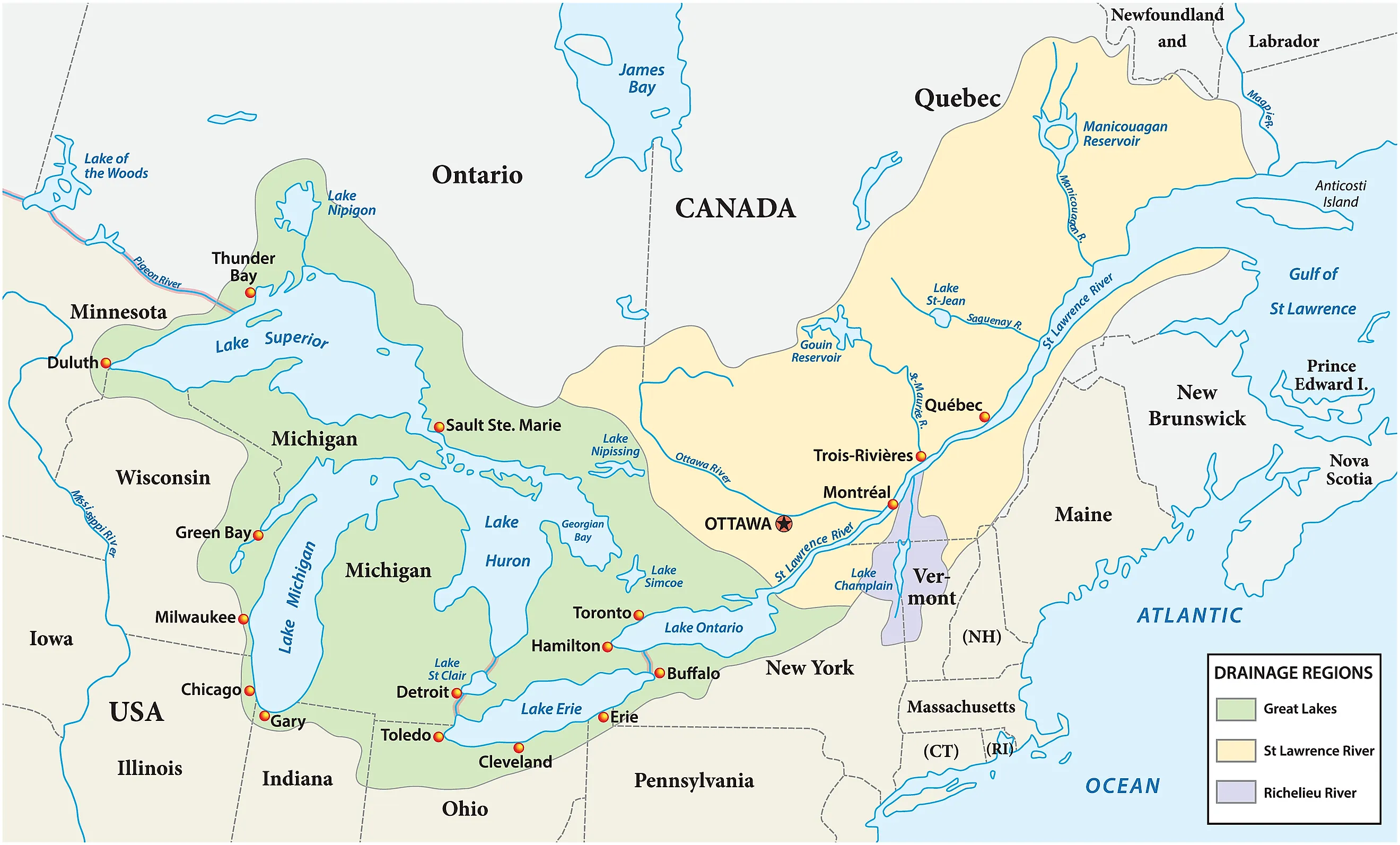
The five Great Lakes of North America form a single interconnected system fed by close to 5,000 tributaries. The exact count varies because seasonal streams disappear and reappear, and tributaries are typically classified by their contribution to the watershed rather than counted at fixed numbers. As a network, the Great Lakes flow west to east through Lake Superior, Lake Huron, Lake Erie, and finally Lake Ontario, which empties into the St. Lawrence River and on to the Atlantic Ocean.
Lake Michigan does not flow directly into Lake Erie. Hydrologically, Lake Michigan and Lake Huron are considered a single body called Lake Michigan-Huron because water flows between the two basins through the Straits of Mackinac, with the surface levels at equilibrium. Through this connection, Lake Michigan's tributary water reaches Lake Erie indirectly.
Lake Superior

Lake Superior has anywhere between 200 and 300 tributaries depending on how they are counted. Around 200 named rivers feed the lake directly. Include small streams and seasonal waterways and the number rises as high as 2,800. Some hydrological models estimate roughly 1,086 distinct tributaries. At 12,300 cubic feet per second, the Nipigon River is the largest by discharge volume. Hydroelectric diversions since 1943 have increased its flow rate by over 50%. The longest tributary is the St. Louis River in Minnesota, which runs 192 miles starting at Seven Beaver Lake near Hoyt Lakes and discharges at 2,284 cubic feet per second. Other major rivers include the Bad River in Wisconsin and, in Ontario, the Kaministiquia, Pigeon, and Michipicoten Rivers.
Tributaries supply roughly 40% of Lake Superior's inflow. Direct precipitation supplies another 50%, and human-made diversions from Hudson Bay contribute roughly 4%. As the first lake in the eastward Great Lakes chain, Lake Superior receives no inflow from the other lakes. Discharge is remarkably small relative to volume, and the retention time for water to be fully replaced runs 191 years. The major outflow is the St. Marys River, which connects Lake Superior to Lake Huron and serves as the only natural outlet from the lake.
Lake Huron

Lake Huron has approximately 1,761 tributaries: 1,334 in Ontario and 427 in Michigan. Thousands of smaller creeks, drains, gullies, and intermittent streams add to that total, which is why the exact figure varies by methodology. Ontario's major tributaries include the Saugeen River, one of the largest draining into the lake and important for regional biodiversity; the Maitland River near Goderich; and the Ausable River along the southeastern shore. The Spanish River empties into the North Channel, the waterway on the north shore bordered to the east by Georgian Bay and to the west by the St. Marys River.
From the Michigan side, the Saginaw River drains the largest watershed in the Lake Huron basin and is itself fed by the Tittabawassee and Flint Rivers. The Thunder Bay River runs through northeastern Michigan into the lake's Thunder Bay, not to be confused with the Ontario city of the same name on Lake Superior. The Tawas River in Iosco County empties into Tawas Bay. With thousands of distinct streams emptying into the lake across two nations, no single official tributary count exists; municipalities and counties use different methodologies.
Lake Michigan

Lake Michigan is the only Great Lake entirely within the United States. Estimates put its tributaries between 300 and 511. It is also the only Great Lake with a north-south orientation, which makes it prone to rip currents and rapid wave growth near the southern end at Chicago and ranks it as one of the deadliest lakes in the United States. Combined with Lake Huron as Lake Michigan-Huron, it becomes the largest freshwater lake in the world by area, surpassing Lake Superior.
The Grand River, the longest river in Michigan, empties into Lake Michigan at Grand Haven. The Kalamazoo River drains a large urban and agricultural watershed in southwest Michigan and reaches the lake at Saugatuck. The St. Joseph River runs through Indiana and Michigan and is noted for its steelhead fishing. In Wisconsin, the Fox River is a major tributary that flows northeast into Green Bay; the Milwaukee River runs through the city of the same name and into the lake. Illinois tributaries such as the Chicago River and Calumet River once drained into Lake Michigan. In 1900, engineers reversed the flow to divert sewage; the Chicago Sanitary and Ship Canal converted both rivers into outflows feeding the Mississippi River basin.
Lake Erie

Lake Erie has about 842 tributaries: 317 in the United States across Michigan, Ohio, Pennsylvania, and New York, and 525 in Ontario. The Lake Huron-Erie Corridor connects the two lakes, with water flowing south from Lake Huron through a 90-mile river system into Lake Erie. The corridor includes the St. Clair River, Lake St. Clair, and the Detroit River. Along Ontario's northern shore, most drainage moves through agricultural and urban land. The largest Ontario tributary is the Grand River, which runs 193 miles and discharges into the lake at Port Maitland. Big Otter Creek sits in the Central Basin with a large watershed known for fishing.
On the Ohio side, the Maumee and Sandusky Rivers are crucial Western Basin tributaries famous for the millions of walleye that run each spring. Pennsylvania's main tributaries are Elk Creek, the largest in Erie County, and Walnut Creek. Cattaraugus Creek is one of New York's most productive steelhead streams and drains into the Eastern Basin. Chautauqua Creek and Canadaway Creek are two other popular fishing tributaries. Beyond the Lake Huron-Erie Corridor, Michigan also contributes the Huron, River Rouge, and River Raisin.
Lake Ontario

Lake Erie connects with Lake Ontario most dramatically through the Niagara River and Niagara Falls. Lake Ontario sits 326 feet lower than Lake Erie, the lowest of the Great Lakes by elevation. The two lakes are also artificially connected through the Welland Canal. Lake Ontario forms part of the border between New York State and Ontario and has more than 100 tributaries. The Canadian shore, especially the corridor from the Niagara River to east of Toronto, is heavily developed. Key Canadian tributaries include the Credit River in Mississauga, the Humber and Don Rivers in Toronto, and the Rouge River east of Toronto. Further east, the Trent River empties into the Bay of Quinte carrying water from the Kawartha Lakes region.
The New York side is generally less developed, with some heavily populated areas along the southern and eastern shores. The Salmon River at Pulaski is one of the most fished tributaries in the entire Great Lakes system. In central New York, the Oswego River forms at the confluence of the Seneca and Oneida Rivers. The Genesee River flows through Rochester and into the lake. From the eastern end of Lake Ontario, water drains into the St. Lawrence River at an average rate of 282,000 cubic feet per second. The St. Lawrence carries the entire Great Lakes outflow northeast for around 744 miles to the Gulf of St. Lawrence and the Atlantic Ocean.
How the lakes connect to each other
For more on the rivers, channels, and canals that link the Great Lakes, read about the major rivers that connect the Great Lakes.
The Great Lakes and Their Tributaries
Across the system, an estimated 22% to 42% of the water entering the Great Lakes comes from their surrounding tributaries. The rough count of over 5,000 tributaries reflects how much of the watershed depends on small and seasonal streams that don't appear on most maps. Each lake drains into the next in a west-east chain that ultimately empties through the St. Lawrence into the Atlantic. As the world's largest surface freshwater system, the Great Lakes depend on these many incoming streams, and the health of any one lake hinges on what is happening upstream in two nations.