Seeking Canada’s Southernmost Points
Canada's southernmost points punch holes in the Great White North image. Point Pelee National Park holds the southernmost spot on the mainland. Pelee Island holds the southernmost place where anyone actually lives. Both push out from Carolinian forests into Lake Erie as long, skinny sand spits you can walk to the end of. Both sit at the latitude of Northern California and run warmer than the rest of the country. I made the trip this spring and brought back two bonus stops worth the detour, starting with the mainland.
The Lake Erie shoreline these spits push out from
For a wider look at the towns along the same lake, see our roundup of the most charming small towns on Lake Erie.
Southernmost Mainland: Point Pelee National Park

Canada's second-smallest national park (and one of its most ecologically diverse) forms an inverted triangle branching off Southwestern Ontario. RAMSAR wetlands, reclaimed forests, and bordering beaches all funnel down to the southernmost point on Canada's mainland, appropriately dubbed "The Tip." To reach The Tip, you're looking at about an hour's drive southeast from Windsor, Ontario, and Detroit, Michigan; a little less than two hours south of Sarnia, Ontario, and Port Huron, Michigan; and spot-on two hours southwest of London, Ontario.

The furthest south you can park is the Point Pelee National Park Visitor Center, about two kilometers north of The Tip. From there, regular shuttles roll out to the trailhead, or you can walk or ride the quiet canopy road yourself. A short hike on parallel sand or gravel trails brings you to the base of the spit (i.e. fancy speak for a peninsula). Then it's just a matter of pushing through the soft sand until water surrounds you on three sides.
On the way out or back, pop up the 24-meter (79-foot) Observation Tower for a wider view of Point Pelee's whole spread of wetlands and woodlands. The tip is the headline, but the park around it is what makes the trip.
Southernmost (Inhabited): Pelee Island

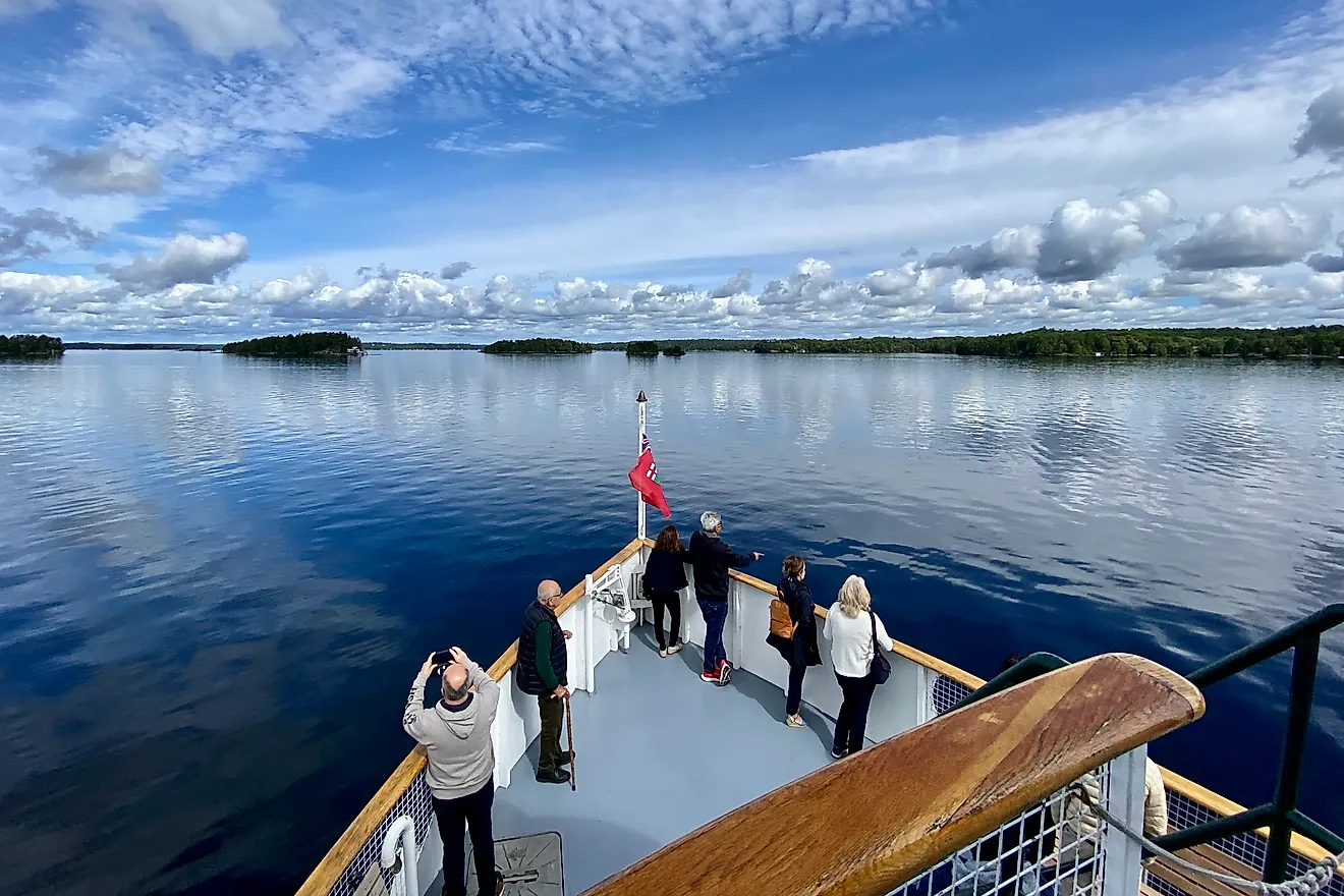
From the tip of Point Pelee, Pelee Island is visible across the water and marks the southernmost inhabited part of Canada. To get there, board the Pelee Islander Ferry from Leamington, Ontario, or Kingsville, Ontario, or even Sandusky, Ohio. That third terminal might catch your eye. Pelee Island is the largest of the archipelago shared between Ontario and Ohio, known simply as the Lake Erie Islands, so in a sense you can think of Pelee as Canada's Kelleys Island.
Cars are permitted on Pelee Island, but I suggest boarding as a pedestrian and renting a bicycle or golf cart once you arrive. That lets you sink into Pelee's slower rhythm and gets you to the island's southernmost point: the sand spit of Fish Point Provincial Nature Reserve.

Park your bike at the trailhead and walk through Fish Point's rainforest-esque interior. Push through a less-trodden trail (you may need to step over a downed tree or two), or, tide pending, walk the slim beach along Mosquito Bay, and you'll spot a long sand spit leading out into Lake Erie. Having just come from Point Pelee, you may feel a strong case of déjà vu. But even though the scenery rhymes, you are now at what is commonly cited as the southernmost point in Canada.
That's true for almost any practical purpose. If you want the actual southernmost point, one more boat ride is required.
Southernmost Point, Period: Middle Island

About five kilometers south of Pelee Island, right on the maritime line with Ohio, floats Canada's true and final southernmost point. Strangely called Middle Island, this 46-acre, uninhabited, undeveloped rock sits at 41°41'N, 82°41'W. The Nature Conservancy of Canada bought the island in 1999, and it has been managed as part of Point Pelee National Park since 2000. No tour boats run here. A private boat is the only way to check this box.
Bonus Destination: Long Point

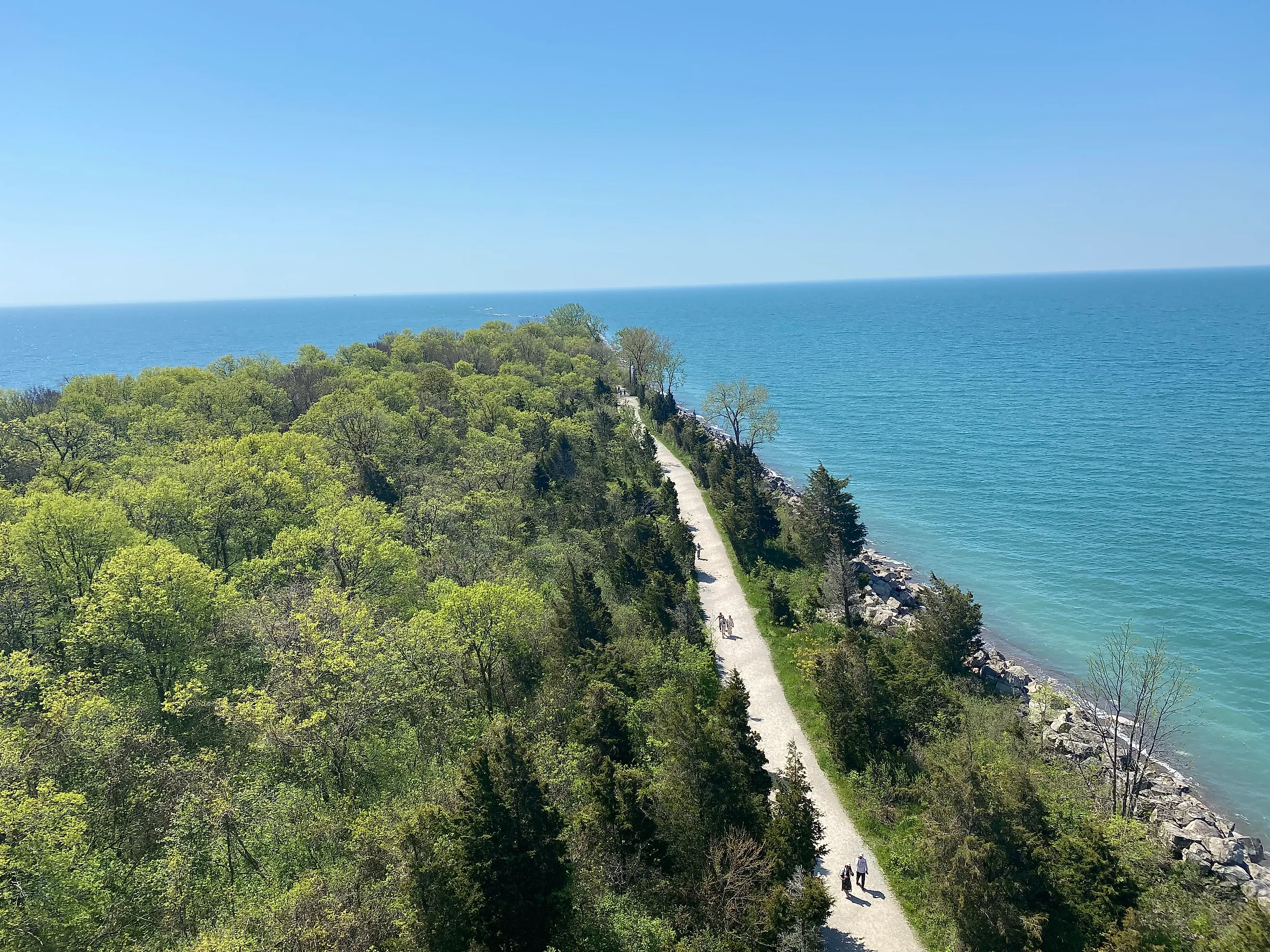
While we're tracking noteworthy sand spits on the Canadian shore of Lake Erie, the Long Point UNESCO Biosphere Reserve deserves the page time. It isn't next in line as a southernmost point, but Long Point is the longest freshwater sand spit on the planet at 40 kilometers, and one of the best bird-watching destinations on the Great Lakes. It sits at roughly the same latitude as the other three features on this list.
The tip of this record-breaking spit falls under the Long Point National Wildlife Area, off-limits to the public, but Long Point Provincial Park and the adjacent Big Creek National Wildlife Area cover a lot of ground. Between the former's beach and the latter's Wetlands of International Importance, this stretch of the Biosphere is one of the largest bird and waterfowl staging areas in North America, with 370 species documented to date. Pack binoculars or a long lens, post up on one of the observation decks, walk the interpretive trails, and you'll see local favorites plus a chance at a federally listed Species at Risk such as the least bittern, prothonotary warbler, or swamp rose mallow. The Long Point Bird Observatory keeps a chalkboard of recent sightings near the lab. Long Point is also a critical roosting and feeding stop for migrating monarch butterflies on their way south.
Another perspective on Lake Erie's north shore
For a sister piece on a Lake Erie beach town up the road from Point Pelee, see our travel story on Port Stanley.
What's The Point?

There are endless strategies for traveling the world: countries to tick off, iconic national parks to behold, trails to thru-hike, cultures to dig into. But for localized expeditions, I like working backwards from geographical extremes. With Canada, the northernmost and westernmost points are out of reach for the Average Janes and Joes. The southernmost points are not just accessible. They are the kind of places that reward the drive and the ferry and the walk through soft sand. The same is true of Canada's easternmost point, Cape Spear, so maybe we head there next.