US States That Border Canada
The United States and Canada border is the longest international border in the world, stretching 5,525 miles (8,891 kilometers) and crossing eight Canadian territories/provinces and thirteen US states. The US states that border Canada include Alaska, Washington, Idaho, Montana, North Dakota, Minnesota, Michigan, Ohio, Pennsylvania, New York, Vermont, New Hampshire, and Maine.
US States Ranked By Their Border Length With Canada
| Rank | State | Length of border with Canada |
|---|---|---|
| 1 | Alaska | 1,538 mi (2,475 km) |
| 2 | Michigan | 721 mi (1,160 km) |
| 3 | Maine | 611 mi (983 km) |
| 4 | Minnesota | 547 mi (880 km) |
| 5 | Montana | 545 mi (877 km) |
| 6 | New York | 445 mi (716 km) |
| 7 | Washington | 427 mi (687 km) |
| 8 | North Dakota | 310 mi (499 km) |
| 9 | Ohio | 146 mi (235 km) |
| 10 | Vermont | 90 mi (145 km) |
| 11 | New Hampshire | 58 mi (93 km) |
| 12 | Idaho | 45 mi (72 km ) |
| 13 | Pennsylvania | 42 mi (68 km) |
Alaska

The border between Alaska and Canada spans 1,538 miles (2,475 kilometers) and is arguably the wildest border on the continent. The border is pronounced in certain places, such as in the Yukon River Valley, where a straight line cuts through the trees and forest on the 141st meridian. In other places, however, the border is virtually undetectable, such as on the 18,008-foot Mt. St. Elias. The land along nearly the entire border is uninhabited, with the only settlement on the border being Hyder, in the extreme southeast of Alaska.
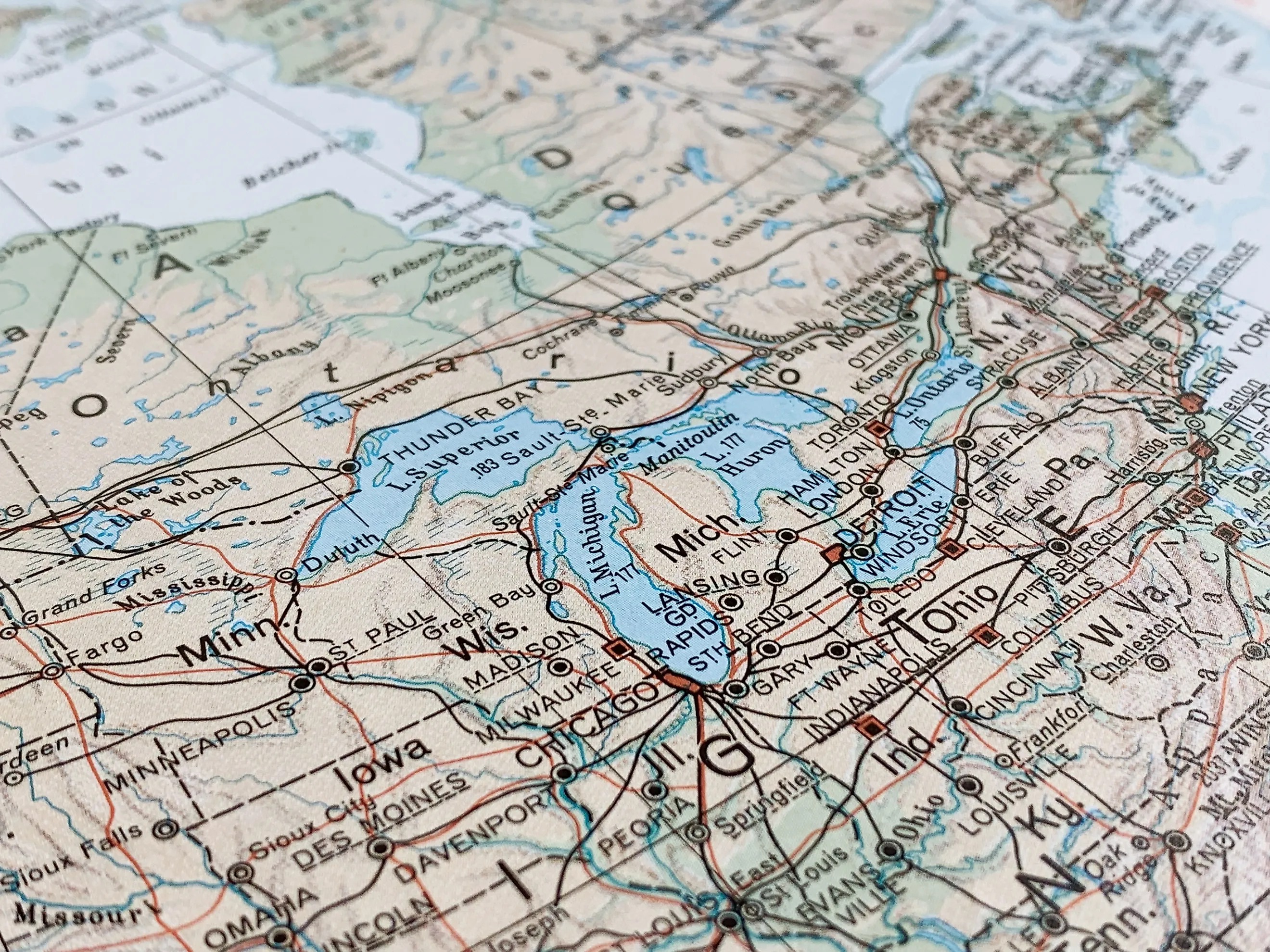
Michigan

Michigan’s border with Canada extends for 721 miles (1,160 kilometers). The state solely borders the Canadian province of Ontario. In total, there are four land border crossings distributed throughout the state, three of which are bridges and one of which is a tunnel: Sault Ste. Marie International Bridge, Ambassador Bridge, Blue Water Bridge, and Detroit Windsor Tunnel. All four crossings are among the top ten busiest in the country and serve as major trucking hubs, though Sault Ste. Marie mainly handles passenger vehicle traffic. Lake Huron and Lake Eeire also both border Canada, along the Michigan border.
Maine

Maine, with a 611-mile (983-kilometer) border with the Canadian province of Quebec, has 24 land border crossings. Some of the country’s busiest crossing points lie within Maine, including Calais-St. Stephen, Madawaska-Edmundston, and Houlton-Woodstock Road are all important trucking transportation points. The St. Croix River is perhaps one of the most significant rivers at the border, forming 71 miles (114 kilometers) of the border between Maine and Quebec. The East Grand Lake, in Maine’s northeast, also straddles between the two countries.
Minnesota

Minnesota has a 547-mile (880-kilometer) long border that it shares with Canada, specifically with the Canadian provinces of Manitoba and Ontario. Along this border, there are eight designated land crossing points, with Warroad Sprague, Baudette Rainy River, International Falls Fort Frances, and Grand Portage Pigeon River receiving the most traffic. There are two main rivers in Minnesota that cross into Canada: The Rainy River and the Pigeon River. The Rainy River is particularly important as it forms a part of the border between the two countries.
Montana

The Montana and Canada border stretches for 545 miles (877 kilometers) and passes through three Canadian Provinces: British Columbia, Alberta, and Saskatchewan. There are thirteen active border crossings in the state, with Roosville Grasmere, Piegan Carway, and Sweetgrass Coutts being the most popular. Truckers often use these three crossings as part of major transportation routes. Additionally, the Saint Mary and Milk Rivers are two major rivers that originate in the Rocky Mountains of Montana before flowing northeast into the Canadian province of Alberta.
New York

New York shares a 445-mile (716-kilometer) border with Canada, crossing the Canadian provinces of Ontario and Quebec. There are 17 crossing points along the state’s border. Similar to Michigan, it has some of the most heavily traveled border crossings in the country. Some of the busiest and most popular crossings include Peace Bridge, Whirlpool Rapids Bridge, Rainbow Bridge, and Lewiston-Queenston Bridge, in the Buffalo-Niagra Falls Area, as well as the Seaway Bridge, Blackpool Champlain, and Thousand Islands Bridge. A portion of the border is also water, consisting of Lake Ontario.
Washington

The Washington and Canada border extends for approximately 427 miles (687 kilometers), sharing a border solely with the Canadian province of British Columbia. In total, there are 13 border crossing points in the state, with the four most popular being the ones near the Seattle and Vancouver metropolitan areas, including Peace Arch, Lynden Aldergrove, Blaine Surrey, and Sumas Huntingdon. These four ports alone receive over 30,000 cars crossing daily, with wait times at the crossing sometimes reaching up to three or four hours during peak times.
North Dakota

The border between North Dakota and Canada extends for 310 miles (499 kilometers) and crosses the Canadian Provinces of Saskatchewan and Manitoba. In total, there are 18 land border crossings, with Portal-North Portal, Neche Gretna, Peace Garden, and Pembina Emerson being the most popular. The Red River of the North is one of the prominent rivers that passes along the North Dakota and Minnesota border before crossing into Canada in the north, ultimately draining into Lake Winnipeg in the Canadian province of Manitoba.
Ohio

Ohio shares a 146-mile (235-kilometer) border with the Canadian province of Ontario. However, the border between Ohio and Ontario is not a physical border but rather bordered by Lake Eerie. As a result, there are no land border crossings between the two countries in the state. Despite the lack of a physical land border, it is not uncommon to see Canadian drivers in Ohio due to its proximity to cities such as Niagra Falls and Windsor.
Vermont

Vermont’s border with Canada is fairly short, spanning just 90 miles (145 kilometers), and passing through the Canadian province of Quebec. The majority of its crossing points are popular with truckers, particularly the Derby Line Stanstead and Highgate Springs Saint Amand. The Missisquoi River, one of the most prominent in northern Vermont, winds through the state before entering southern Quebec, covering about 80 miles (130 kilometers). Lake Champlain also stretches from northwestern Vermont, with a small section reaching into southern Quebec.
New Hampshire

The border between New Hampshire and Canada extends for approximately 58 miles (93 kilometers), with the Canadian province of Quebec sitting across. It has only one border crossing: the Pittsburg Chartierville Crossing, which receives about 10,000 vehicles each year. Along the New Hampshire-Quebec border, the Quebec side is generally more populated and civilized, with farms and roads frequently scattered up to the border. To the south, there are generally only a few lakes, trees, and mountains.
Idaho

The border between Idaho and Canada is remarkably short, covering just 45 miles (72 kilometers) at the northern tip of Idaho’s panhandle. Similar to Washington State, Idaho only shares a border with the British Columbia province of Canada. There are just two land border crossings: Eastport-Kingsgate and Porthill-Rykerts. The Porthill-Rykerts crossing generally receives more passenger vehicles, while Eastport-Kingsgate receives larger trucks. There are various rivers that flow from Southern Canada into Idaho, including the Upper Priest River, which passes through the border before emptying into Idaho’s Priest Lake.
Pennsylvania

Similar to Ohio, Pennsylvania doesn’t share a land border with Canada; instead, Lake Erie separates it from Ontario. The border between Pennsylvania and Ontario is also the shortest in the country, stretching only 42 miles (68 kilometers). The town of Erie, Pennsylvania, situated along Lake Erie in northwestern Pennsylvania, has just over 93,000 residents and is about a four-hour drive from Toronto, Ontario's capital.
Along the world’s longest international border, the numerous crossing points—many heavily trafficked—serve as a reminder of the enduring connectivity between Canada and the United States despite their status as separate countries. Additionally, the many rivers and lakes shared highlight the geographic similarity between the northern United States and Southern Canada. Although there are currently not a lot of major cities along the United States and Canada border, future collaboration and further connections between the two countries will continue to strengthen their relationship and enhance economic opportunities for both sides.


