12 Most Beautiful Rivers In America
America keeps its best scenery near running water. Carve a path for a river and sooner or later you get a canyon, a salmon run, a string of towns, or a valley that people drive a thousand miles to photograph. The twelve rivers below were not chosen for length or volume but for the simple fact that they are a pleasure to stand beside, from a turquoise glacial channel in Alaska to a slow tannin-dark creek in Florida. Here is what makes each one worth the trip.
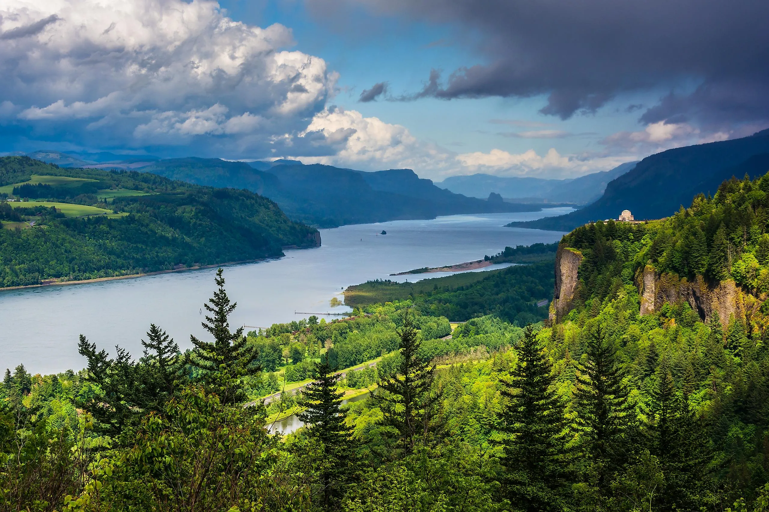
Columbia River

The Columbia is the largest river that pours into the Pacific from North America, and it spends about 2,000 kilometers earning the title. It rises in the Canadian Rockies of British Columbia, swings down through Washington and Oregon, and finishes at the sea near Astoria, gathering enough water along the way to drive roughly a third of the hydropower potential in the United States. The stretch most people come to see is the Columbia River Gorge, where the water has cut a corridor through the Cascades and the walls run with waterfalls. Chinook salmon still fight their way up it every year, the way they have for as long as people have lived on its banks.
Hanalei River

On the north shore of Kauai, the Hanalei packs a remarkable amount of scenery into just 26 kilometers. It starts about 3,500 feet up the green slopes of Mount Waialeale, a shield volcano that tops out at 5,148 feet and counts among the rainiest places on the planet, then drops through tropical forest to Hanalei Bay. The flat lower stretch runs past taro farms that grow roughly 60 percent of all the taro in Hawaii, which is why so many old photographs of the valley are really photographs of flooded fields catching the light. President Bill Clinton named it an American Heritage River on July 30, 1998, one of only fourteen rivers in the country to hold that designation.
Colorado River

No river has rearranged a landscape quite like the Colorado. Over roughly 2,330 kilometers it runs from the Rocky Mountains through Colorado, Utah, Arizona, Nevada, and California before crossing into Mexico toward the Gulf of California. Its signature work is the Grand Canyon, a 446-kilometer gorge of banded rock that the river is still grinding deeper. Today it does double duty as scenery and plumbing, supplying water to tens of millions of people across the Southwest, which is also why it so rarely reaches the sea anymore. Float a raft through the canyon at first light, with the gray walls catching fire as the sun hits them, and the appeal needs no further explanation.
Rio Grande

At about 3,051 kilometers, the Rio Grande is the fourth-longest river in the United States, running from the San Juan Mountains of southern Colorado down through New Mexico and along the entire Texas border with Mexico before emptying into the Gulf of Mexico. Its watershed covers roughly 472,000 square kilometers of mostly dry country, which is the whole story of the river in a single number. So much of its water is pulled out for cities and farms that only a fraction of the natural flow now reaches the gulf, and stretches of it run low or dry in bad years.
That fragility has made it one of the most closely watched rivers in the country. Conservation groups, three states, and two nations all have a stake in how its water gets divided, and reservoir and restoration projects up and down the basin are an attempt to keep one of the Southwest's defining rivers from thinning out altogether.
Hudson River

The Hudson takes its name from Henry Hudson, the English navigator who sailed up it in 1609 while looking, unsuccessfully, for a shortcut to Asia. Over its 507 kilometers the river falls out of the Adirondack Mountains, widens through the Hudson Valley, and meets the Atlantic at New York City, marking part of the border with New Jersey on the way. Its scenery did something unusual in American art: in the 19th century it gave its name to the Hudson River School, the first homegrown movement of landscape painters, who treated the valley's light and cliffs as subjects worthy of a canvas. The best of those views are still upriver, well north of the city skyline.
Kenai River

Alaska's Kenai runs 132 kilometers from Kenai Lake, high in the Kenai Mountains, down through forest and lake to Cook Inlet, and it does it in a shade of glacial turquoise that looks almost artificial in photographs. This is the most popular sportfishing river in the state, famous above all for king salmon: the world-record Chinook, a 97-pound fish, was pulled from the Kenai in 1985 and has never been beaten. Bears and moose work the banks for the same fish the anglers want, and snow stays on the surrounding peaks well into summer, so the whole scene tends to look like the brochure that talked you into visiting in the first place.
Truckee River

The Truckee has an unusual job: at 195 kilometers it is the sole outlet of Lake Tahoe, carrying that famous blue water northeast out of the mountains and into Pyramid Lake, a desert lake with no outlet of its own. Along the way it is western Nevada's largest river and the lifeline of Reno and Sparks, which drink its treated water. Its flow is regulated at the Lake Tahoe Dam, but the clear water and pine-lined banks still make it a summer magnet for fishing and whitewater rafting, with crowds arriving from both sides of the California-Nevada line.
Potomac River

The Potomac is the river of the nation's capital, running 652 kilometers and draining a basin of about 38,000 square kilometers as it forms the boundary between Maryland and Washington, DC. In the city it is all monuments and calm water near the Jefferson and Lincoln Memorials, but follow it upstream into Virginia and West Virginia and the banks turn wooded and wild. The highlight is Great Falls, a churn of rapids and ledges roughly 24 kilometers above the capital, where the river drops hard through a rocky gorge and draws rafters, kayakers, and hikers out of the city on weekends.
Crooked River

A 201-kilometer tributary of the Deschutes River, central Oregon's Crooked River more than earns its spot on scenery alone. It winds through Smith Rock State Park, a cathedral of basalt and tuff that helped invent modern American sport climbing, and threads a string of canyons good for fishing, hiking, and camping. The Northern Paiute called it something close to "deep canyon creek," and the reason is on full display at the Crooked River Railroad Bridge in Jefferson County, a 1911 steel arch that crosses the gorge 320 feet above the water. Look down from the viewpoint there and the river is a thin green ribbon at the bottom of the rock.
Loxahatchee River

The Loxahatchee takes its name from a Seminole word meaning "river of turtles," and at only 12 kilometers it is the shortest river on this list by a wide margin. What it lacks in length it makes up for in status: it is a National Wild and Scenic River, one of just two in Florida, protected since 1985. This is slow, dark, cypress-lined water made for an unhurried paddle, the kind of trip where the point is to drift and watch. Keep an eye on the surface and you may spot a manatee before the river reaches the Atlantic at Jupiter Inlet, on the state's southeast coast.
Merced River

Spanish explorer Gabriel Moraga named it El Rio de Nuestra Senora de la Merced, the River of Our Lady of Mercy, in 1806, and the Merced has been collecting admirers ever since. Over 233 kilometers it runs from the high Sierra Nevada through Yosemite National Park and down into the San Joaquin Valley, with El Capitan and the granite walls of Yosemite Valley rising straight out of its banks. People have lived along it for thousands of years, and the lure was strong enough to pull Gold Rush prospectors into its lower reaches. The first 122 miles were named Wild and Scenic in 1987, and in spring the meadows beside it fill with wildflowers.
Salt River

The Salt River rises in the White Mountains of eastern Arizona and runs about 320 kilometers down to the Phoenix area, where it joins the Gila. The desert stretch closer to the city is the postcard: this is one of the few rivers to flow through the saguaro forests of the Sonoran Desert, and the lower river, where it borders the Tonto National Forest, is home to a famous band of wild horses that wade and graze right at the water's edge. Around them the recreation runs from tubing and fishing to rock climbing and stargazing, all within easy reach of one of the largest cities in the Southwest.
Still Worth the Drive
What ties these twelve together is not size or fame but the way each one rewards showing up in person. A river photographs well, but it is the sound, the cold air coming off the water, and the scenery it carved that make the difference. Pick the one closest to you, find a bank to stand on, and the rest takes care of itself.


