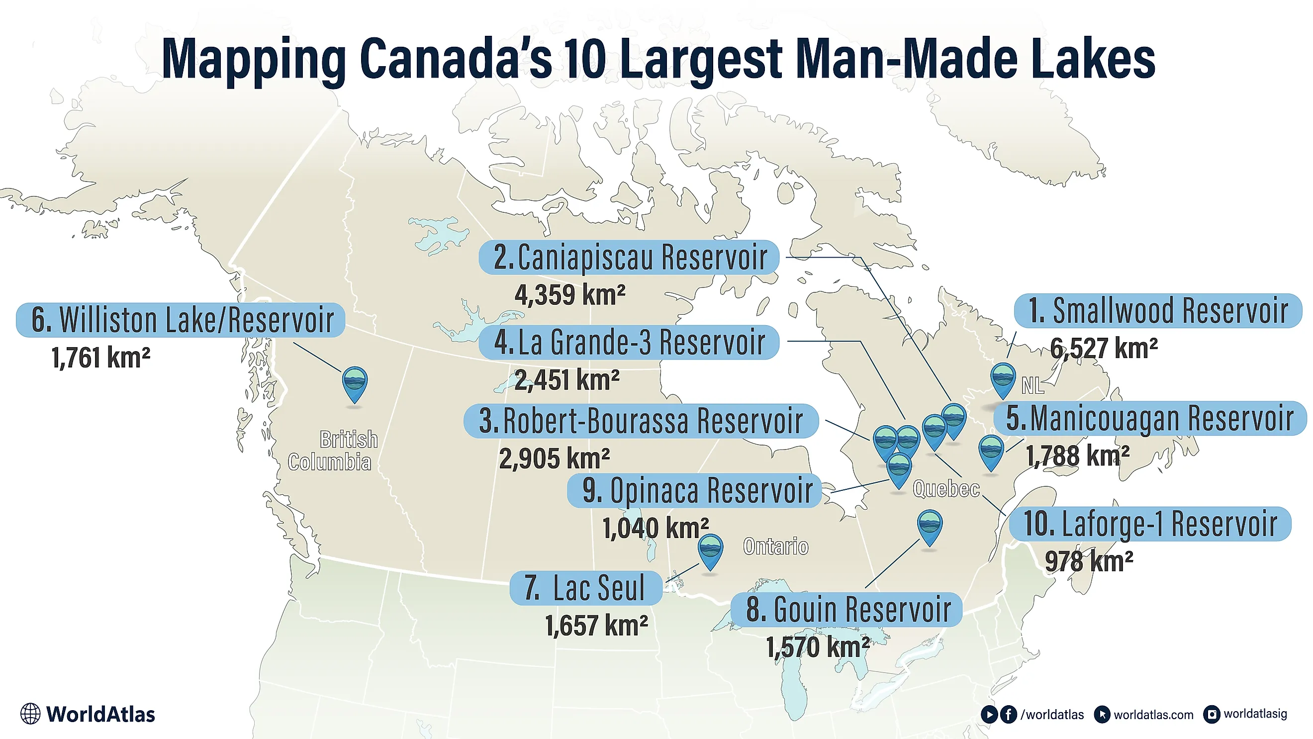
10 Largest Man-Made Lakes In Canada
To create these lakes, engineers drowned entire rivers, forests, and ancient basins to store water for hydroelectric power. Most sit in the remote north, especially Quebec, where the James Bay and La Grande projects turned whole watersheds into one of the world's largest clean-energy systems. Labrador's Smallwood Reservoir and British Columbia's Williston Lake swallowed entire valleys to feed their provincial grids.
Ranked here by surface area, these ten reservoirs trace the sheer scale of Canada's water infrastructure. A few are celebrated for the power they produce. Others carry a hard legacy for Indigenous territories and northern communities. And one, Manicouagan, fills a 200-million-year-old meteor crater you can spot from space. Each one shows how geography, engineering, and electricity reshaped the modern Canadian map.
10 Largest Man-Made Lakes In Canada
| Rank | Man-made lake / reservoir | Province | Reported area |
|---|---|---|---|
| 1 | Smallwood Reservoir | Newfoundland & Labrador | 6,527 km² |
| 2 | Caniapiscau Reservoir | Quebec | 4,359 km² |
| 3 | Robert-Bourassa Reservoir | Quebec | 2,905 km² |
| 4 | La Grande-3 Reservoir | Quebec | 2,451 km² |
| 5 | Manicouagan Reservoir | Quebec | 1,788 km² |
| 6 | Williston Lake / Reservoir | British Columbia | 1,761 km² |
| 7 | Lac Seul | Ontario | 1,657 km² |
| 8 | Gouin Reservoir | Quebec | 1,570 km² |
| 9 | Opinaca Reservoir | Quebec | 1,040 km² |
| 10 | Laforge-1 Reservoir | Quebec | 978 km² |
1. Smallwood Reservoir, Newfoundland & Labrador

Smallwood Reservoir stretches across western Labrador and stores water for the Churchill Falls Generating Station on the Churchill River system. At 6,527 km², it ranks first among Canada’s man-made lakes by surface area. Unlike many reservoirs, it is not held back by a single large dam; instead, dozens of dikes close gaps across the Labrador Plateau. The project flooded and connected former rivers, marshes, bogs, and smaller basins, including the Michikamau and Lobstick areas, into one immense storage system. Its name honours Joey Smallwood, Newfoundland’s first premier. Beyond its size, the reservoir is important because it helped turn Churchill Falls into a cornerstone of eastern Canadian electricity supply and demonstrated Labrador’s vast inland waterpower potential.
2. Caniapiscau Reservoir, Quebec

Caniapiscau Reservoir occupies a remote part of northern Quebec. At 4,359 km², it is the province’s largest inland water body. It formed when Lake Caniapiscau and nearby basins were flooded for the James Bay power program. Stored water can be redirected west into the main generation corridor, helping meet peak winter demand. The name is often interpreted as “rocky point,” a fitting reference to the rough shorelines, exposed bedrock, tundra edges, and boreal terrain that surround it. Access remains difficult, mostly by aircraft or the long Trans-Taiga Road. Because of that isolation, the area feels less like a settled lake district and more like a vast engineered storage basin in subarctic wilderness.
3. Robert-Bourassa Reservoir, Quebec

The 2,905 km² Robert-Bourassa Reservoir lies on the upper La Grande River. Developed in the 1970s, it stores water for the Robert-Bourassa and La Grande-2-A stations, two major producers in Quebec’s northern power grid. The main dam is supported by numerous dikes, allowing engineers to control water levels across a broad Canadian Shield basin. Although the lake contains a vast quantity of water, only a managed portion is drawn for generation. Its setting is sparsely populated, with black spruce forest, muskeg, rock outcrops, and long river valleys dominating the landscape. As a result, the site functions less as a recreation-focused lake and more as a primary storage anchor for Quebec’s electricity network.
4. La Grande-3 Reservoir, Quebec

Measuring 2,451 km², La Grande-3 Reservoir feeds a large generating station in Nord-du-Québec. The facility was developed during the province’s northern power expansion and uses twelve Francis turbines to convert controlled water releases into electricity. Sakami, a nearby locality, grew out of construction activity linked with the project. The surrounding country is remote, with forest, muskeg, bare rock, and long drainage corridors leading toward James Bay. Unlike a natural lake shaped mainly by glacial processes, this impoundment is managed for energy production, with dams and operating rules controlling seasonal levels. Its main role is to provide reliable storage for one of Canada’s most productive hydroelectric regions.
5. Manicouagan Reservoir, Quebec

Manicouagan Reservoir, often called Lake Manicouagan, spans 1,788 km² in central Quebec and is famous for its ring-like shape. The water surrounds René-Levasseur Island inside an ancient impact crater, creating the “Eye of Quebec” appearance visible on satellite images. The modern reservoir took shape in the 1960s after the Daniel-Johnson Dam raised water levels across several older lakes. From there, flows move through the Manicouagan River toward major downstream power stations. The place stands out because it combines two stories at once: a dramatic geological origin and a modern energy purpose. Forested shores, cliffs, cold water, and the island at its centre make it one of Canada’s most recognizable artificial lakes.
6. Williston Lake / Reservoir, British Columbia

At 1,761 km², Williston Lake is British Columbia’s largest lake by surface area, held behind the W. A. C. Bennett Dam on the Peace River. Completed in the late 1960s, the impoundment filled parts of the Rocky Mountain Trench and created three long arms: the Peace, Parsnip, and Finlay reaches. It is named for Ray Gillis Williston, a provincial minister associated with land and resource planning. The flooding reshaped a huge northern interior landscape and deeply affected Tsay Keh Dene territory. Today, this northern impoundment supports electricity generation, flood control, and regional water management. Its scale, mountain setting, and complex shoreline make it a defining engineered lake of western Canada.
7. Lac Seul, Ontario

Lac Seul covers 1,657 km² in northwestern Ontario, spreading in a long, crescent-shaped outline across Kenora District. Its levels are regulated for storage, rising and falling with seasonal demand and downstream management needs. The shoreline is broken by bays, islands, channels, and shoals, creating habitat that supports notable walleye and northern pike fisheries. The reservoir also sits within the former basin of Glacial Lake Agassiz, linking the modern waterway to a much older landscape history. For generations, these waters formed part of Indigenous travel routes and later fur-trade connections between the English, Winnipeg, and larger northern river systems. Today, it remains both a working reservoir and a major fishing destination.
8. Gouin Reservoir, Quebec

The 1,570 km² Gouin Reservoir sits near La Tuque in Mauricie and regulates the upper Saint-Maurice watershed. It was formed through early twentieth-century impoundment, then adjusted through later control works for power production, timber movement, and downstream flow management. The name honours Jean Lomer Gouin, a former premier of Quebec. Its maze of bays, islands, peninsulas, and channels gives the lake a complex shoreline that attracts anglers, outfitters, and wilderness travellers. Obedjiwan, also known as Opitciwan, sits on the north shore, and earlier flooding forced local relocation. In both geography and history, Gouin is closely tied to Atikamekw territory and the resource economy of central Quebec.
9. Opinaca Reservoir, Quebec

The 1,040 km² Opinaca Reservoir lies east of James Bay in a remote section of northern Quebec. It sits south of Robert-Bourassa Reservoir and connects with both the Opinaca and Eastmain river systems. A long narrows links it to Eastmain Reservoir, making it part of a wider controlled network. Filling began around 1980 during a major phase of northern energy construction. The surrounding landscape is mostly boreal woods, muskeg, low rock ridges, and quiet waterways, with little permanent settlement nearby. Its main role is storage and flow regulation, helping direct water through the broader production system that sends electricity from Quebec’s northern rivers toward consumers far to the south.
10. Laforge-1 Reservoir, Quebec

The 978 km² Laforge-1 Reservoir is part of the Laforge River development, a tributary system feeding a major northern Quebec power network. The dam, storage basin, and generating station were commissioned in the early 1990s, adding 878 MW of installed capacity. Stored water is released through the facility to support electricity production across the wider northern complex. The surrounding area is highly isolated, reached only by long roads and service routes. Black spruce, wetlands, exposed shield rock, and branching waterways dominate the scenery. Permanent settlement is minimal, so the site is best understood as specialized energy infrastructure rather than a conventional lakeside destination.
Canada’s largest man-made lakes are more than oversized reservoirs. They are places where national energy needs, provincial development, northern geography, and Indigenous histories overlap. Their surfaces may look like wilderness on a map, but their shorelines mark some of the most ambitious engineering projects in the country. From Labrador’s Smallwood Reservoir to Quebec’s James Bay network and British Columbia’s Williston Lake, these reservoirs continue to power cities far away while reshaping the lands and waters around them. Taken together, they show the scale of Canada’s hydroelectric age and the lasting imprint of building power systems across some of the country’s most remote landscapes.