The 10 Fastest Dying Rivers Of The United States
Rivers do a remarkable amount of quiet work. They supply our drinking water, irrigate the crops we eat, generate electricity, carry barges full of grain, and shelter a huge share of the country's wildlife. So when a river starts to fail, the trouble spreads well beyond its banks. Across the United States, a number of rivers are under serious strain from drought, dams, pollution, and simple overuse, and several show up year after year in the annual most-endangered list published by the conservation group American Rivers.
Here are ten US rivers facing some of the heaviest threats, and where each one stands today. They are not ranked by any precise measure of how fast they are declining; think of this instead as a tour of waterways in real trouble, and of what it would take to turn them around.
Colorado River

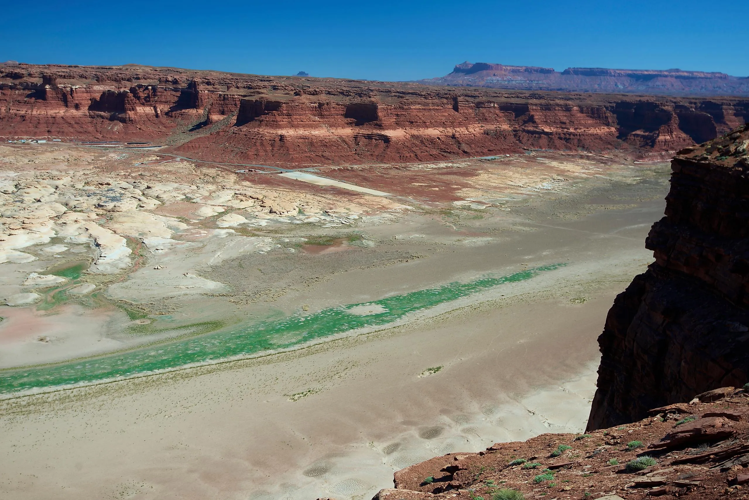
No American river is watched more anxiously than the Colorado. Over its roughly 1,450 miles it supports around 40 million people across seven states, 30 tribal nations, and part of Mexico, watering desert cities and millions of acres of farmland and spinning the turbines at Hoover and Glen Canyon dams. The problem is that there is no longer enough of it to go around.
A megadrought now in its 26th year, made worse by a warming climate, has cut the river's flows by about 20 percent since 2000. Its two great reservoirs, Lake Powell and Lake Mead, sat at roughly 25 and 34 percent of capacity in early 2026, with Powell barely above the level where Glen Canyon Dam can still release water normally. The deeper issue is older: the 1922 compact that divides the river promised out more water than it reliably carries, because it was written during an unusually wet stretch. The short-term cuts the states agreed to for 2023 through 2026 expire at the end of 2026, and the seven basin states have been deadlocked for nearly two years over what comes next, while federal managers prop up Powell with emergency releases from upstream.
Snake River

The Snake River runs more than a thousand miles from Wyoming through Idaho and into Washington, where it joins the Columbia. Its basin once produced close to half of all the Chinook salmon and steelhead in the entire Columbia system. Four federal dams on the lower Snake, built between 1961 and 1975, turned long stretches into warm, sluggish reservoirs that block migrating fish and overheat the water they need, and wild runs have collapsed to a small fraction of their historic size. Salmon are also central to the treaty rights and traditions of the region's tribes.
There has been dramatic movement here. In December 2023, the federal government, four tribal nations, and the states of Oregon and Washington signed a landmark agreement committing more than $1 billion to begin replacing the power, irrigation, and shipping the dams provide, so that the dams could eventually be removed, and paused decades of lawsuits. In June 2025, though, the federal government withdrew from that agreement, and the litigation resumed. Actually breaching the dams would still require an act of Congress, so the river's future remains unsettled.
Mobile River

Alabama's Mobile River drains an enormous swath of the state before emptying into Mobile Bay and the Gulf, and its basin is one of the richest places for freshwater life in North America. The chief threat is contamination. Alabama Power's Plant Barry stores roughly 21 million tons of coal ash in an unlined pond next to the river, and the fear is that toxic metals will leach into the water that supplies the Mobile-Tensaw Delta, the historic Africatown community, and the drinking supply of communities downstream. Cleaning up the river means dealing with that ash.
Maine's Atlantic Salmon Rivers

Maine's Kennebec, Penobscot, and neighboring rivers hold the last wild, self-sustaining runs of Atlantic salmon in the United States, a population now federally listed as endangered. The rivers themselves offer exactly the cold, high-quality habitat the fish need, if only the salmon can reach it. Dams stand in the way, and decisions about whether to relicense or remove them will go a long way toward deciding whether these last runs survive. Reconnecting the rivers would help both the fish and the people whose livelihoods depend on them.
Coosa River

The Coosa, another river in the Mobile basin, was once among the most biodiverse waterways on the continent. A chain of dams built last century is blamed for one of the worst documented die-offs of aquatic species in North American history, wiping out dozens of kinds of snails and mussels. What remains is further stressed by runoff from farms and poultry operations. Conservationists are pushing for stronger Clean Water Act enforcement to protect the water for the wildlife and communities that still depend on it.
Mississippi River

The upper Mississippi River runs about 1,250 miles between Lake Itasca in Minnesota and the point where it meets the Ohio at Cairo, Illinois, and the larger system supplies drinking water to millions. Its long-standing problem is pollution, much of it farm runoff that feeds a low-oxygen dead zone in the Gulf of Mexico. Lately it has faced the opposite extreme too. Severe drought in 2022 and 2023 dropped the lower river to record lows that stranded grain barges, and in the fall of 2023 the weakened flow let a wedge of seawater push upstream toward New Orleans, threatening the region's drinking water until federal engineers stepped in.
Lower Kern River

The Kern River tumbles out of the southern Sierra Nevada into the San Joaquin Valley and through Bakersfield. So much of its water is diverted to irrigate the valley's farms that long stretches of the riverbed through the city often sit bone dry. There has been a push to change that: a campaign called Bring Back the Kern, backed by a 2023 court ruling, forced water releases to keep the river flowing through town. It is a hard-won and partial revival, and the legal fight over how much water the river should keep has continued.
San Pedro River

The San Pedro, which flows north out of Mexico into Arizona, is one of the last major free-flowing desert rivers in the Southwest, and its ribbon of streamside forest draws millions of migrating birds each year. Its weakness is what it cannot see: the groundwater beneath it. Heavy pumping to supply nearby growth is drawing down the aquifer that keeps the river alive, and long reaches have already gone dry. Without firmer limits on pumping, the whole corridor is at risk.
Los Angeles River

The Los Angeles River runs about 51 miles across the city. After a series of deadly floods in the early 20th century, engineers encased most of it in concrete to move stormwater out to sea as quickly as possible, and today much of it is a paved channel rather than a living river. It is not a lost cause, though. An ambitious revitalization plan aims to restore green banks, wildlife habitat, and public access along stretches of the river, which would make the city more resilient to a hotter, drier future.
Tar Creek
In northeastern Oklahoma, Tar Creek runs through the old Tri-State Mining District around the town of Picher, now one of the largest and most contaminated Superfund sites in the country. Roughly seven decades of lead and zinc mining, running into the 1970s, left mountains of toxic waste behind. Acid drainage still bleeds from the old workings and stains the creek orange with heavy metals, a hazard to the Quapaw Nation and other communities who live nearby. Decades into the cleanup, restoring the creek to health remains a long-term project.
What These Rivers Have in Common
The thread running through this list is that almost none of these rivers are failing on their own. They are being drained, dammed, and polluted faster than they can recover, and a warming climate is sharpening every one of those pressures. The encouraging news is that rivers can come back when we let them. On the Klamath, along the Oregon and California border, the largest dam-removal project in US history was finished in 2024, and salmon swam into stretches they had not reached in more than a century. What the rivers here need is not complicated so much as difficult: leaving more water in them, rethinking the dams that strangle them, and keeping the pollution out.


