The Parts Of The American Seafloor Nobody Has Mapped
In January 2024, a team of federal and university scientists announced something startling about a stretch of ocean floor sitting barely 100 miles off Charleston, South Carolina, and Miami, Florida: it was covered in living coral, and nobody had known. The Blake Plateau had been charted for decades and written off as a flat, sediment-covered shelf. New sonar surveys instead revealed 6.4 million acres of cold-water coral mounds, an area bigger than Vermont, hiding in a part of the Atlantic that mapmakers thought they already understood. It is a reminder that "unmapped ocean" does not only mean some remote trench near a foreign coastline. A surprising share of it is sitting in American waters, a few days' boat ride from home.
Why Nearly Half Of America's Own Waters Are Still A Blank Spot

Mapping the seafloor is not like mapping land, where satellites can photograph nearly every square foot from orbit. Water blocks the signals satellites rely on, so most of the seafloor has to be measured the slow way, using sonar mounted on ships that criss-cross the water one line at a time, or robotic vehicles that can spend hours reaching a single stretch of bottom. That is why, more than 50 years after the Apollo missions, NOAA and outside researchers still estimate that over 80% of the world's ocean floor has never been mapped in high resolution, even as the surface of Mars has been charted in detail.
The United States has its own version of that gap. The National Ocean Mapping, Exploration, and Characterization Council, a coalition of federal agencies convened under the Ocean Science and Technology Subcommittee, coordinates the push to close it, with a goal of fully mapping the country's deep waters and coastlines by 2040. In 2025 alone, the mapping community added roughly 70,700 square nautical miles of new coverage, but the remaining gap remains enormous and is not evenly distributed. Some American waters are already well charted. Others are barely touched.
The Great Lakes Are The Most Unmapped Water In The Country
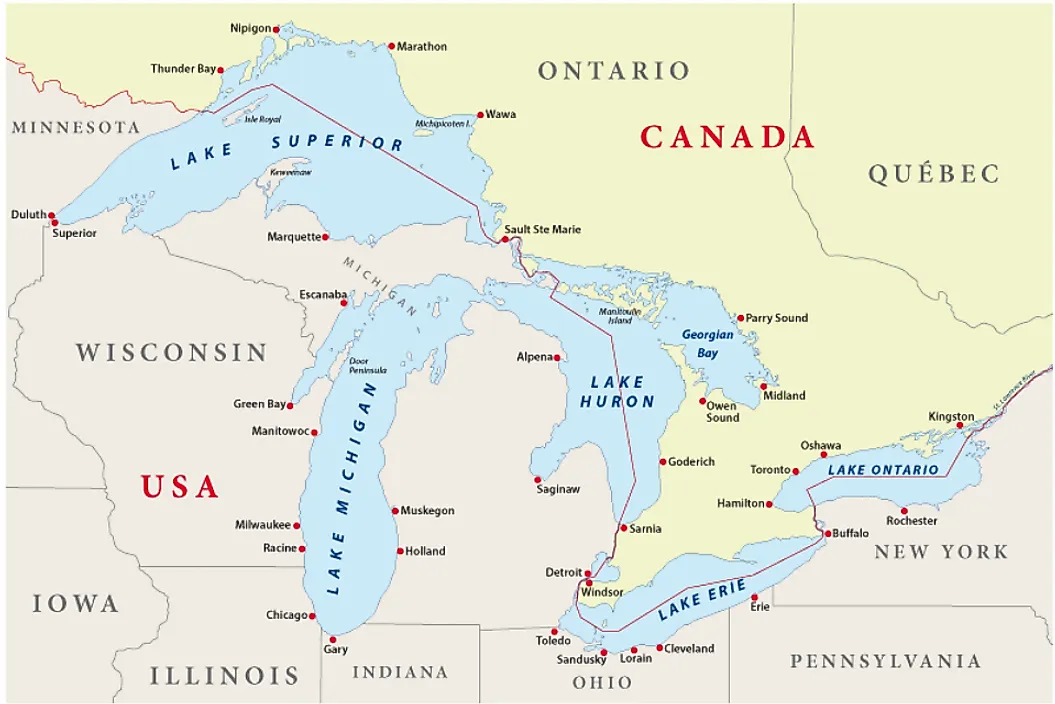
It seems counterintuitive that freshwater lakes bordered by some of the country's biggest cities would be less understood than the open ocean, but the Great Lakes carry the highest unmapped percentage of any US region, at roughly 83% as of the most recent federal count. Millions of people live on their shores, yet most of the lakebeds beneath Lake Michigan, Lake Superior, Lake Huron, Lake Erie, and Lake Ontario have never been surveyed with modern sonar.
The gaps show up in what keeps turning up. Around 6,000 vessels are believed to have sunk across all five Great Lakes, and researchers keep finding wrecks and other strange things in stretches that nobody had closely examined. Off Sheboygan, Wisconsin, sonar crews mapping the lakebed of Lake Michigan found dozens of unexplained circular depressions, features that are still debated among geologists. Great Lakes mapping accounted for a small share of national 2025 progress, which is part of why the region remains the country's biggest blind spot.
Alaska's Vast, Icebound Seafloor

Alaska accounts for the single largest unmapped area in the country by sheer size, with roughly 61% of its waters still uncharted even after some of the strongest mapping gains of any region in 2025. The state's coastline is longer than the rest of the country's combined, and its waters are remote and often ice-covered for months at a time, leaving ship traffic with limited windows to run modern multibeam sonar.
That gap has real consequences. Alaska sits along the Aleutian Trench, a subduction zone capable of producing major earthquakes and tsunamis, and precise seafloor mapping is part of how scientists model that risk for coastal communities. NOAA's Seascape Alaska mapping campaigns, run in partnership with the state and academic institutions, have targeted priority areas for exactly this reason, but with a coastline this size, the work is expected to continue for years.
Gulf Coast And Caribbean Waters Still Hide Surprises

The Gulf of Mexico and the Atlantic seaboard together account for about 28% unmapped, and the Caribbean shows a similar gap. Even here, close to some of the busiest shipping lanes in the country, expeditions keep finding features nobody had previously documented. In the Gulf, NOAA's Okeanos Explorer team came across a hypersaline brine pool roughly 1,260 meters (4,135 feet) down, dense enough to pool and flow like a lake within the ocean, complete with its own shoreline of anemones, tubeworms, and crustaceans clustered around the edge.
Farther east, the Milwaukee Deep, part of the Puerto Rico Trench north of the island, is the deepest point in the Atlantic Ocean at 8,376 meters (27,480 feet), measured during the 2018 Five Deeps Expedition. It sits close enough to a US territory that it falls within American-administered waters, yet the deepest part of the Atlantic remains one of the least visited places on the planet.
The Pacific Territories And The Deepest Water On Earth

Hawaii and the Pacific Remote Islands, a scattering of US territory stretching thousands of miles across the central Pacific, sit at roughly 41% unmapped. The distances involved are part of the problem, as some of these waters are thousands of miles from the nearest port capable of servicing a mapping vessel.
The same ocean holds the planet's most extreme example of the unmapped-seafloor problem, sitting right at the edge of American jurisdiction. The Mariana Trench Marine National Monument, a protected zone in the waters around Guam and the Northern Mariana Islands, covers the submerged lands of the trench itself. Just beyond its boundary, inside the exclusive economic zone of the Federated States of Micronesia, lies Challenger Deep, the deepest known point in any ocean. Modern surveys put its depth at approximately 10,935 meters (35,876 feet), a figure now used consistently across NOAA and academic sources after decades of inconsistent measurements. More people have reached the bottom of Challenger Deep than have walked on the Moon, but only barely, and most of the trench around it remains known only in broad outline.
Charting America's Own Final Frontier
The throughline across all of these regions, from the Great Lakes to the Gulf to the far reaches of the Pacific, is that "unmapped" does not mean unreachable or foreign. It also means a lake five miles from a major American city, or a plateau a short flight from Atlanta, or a trench that technically falls within US jurisdiction. NOAA's 2040 target for finishing the job is still more than a decade off, and every year of new sonar data tends to turn up something nobody expected, the way the Blake Plateau's coral did. For now, a meaningful share of the American seafloor is still exactly what it has always been: close by, and yet largely unknown.