The Longest Rivers Flowing Out Of The Great Lakes
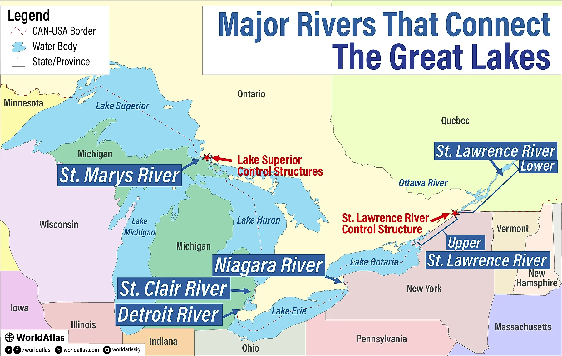
The five Great Lakes form one of the world's largest interconnected freshwater systems, with the vast majority of its water flowing eastward from Lake Superior to the Atlantic Ocean. Although the lakes are enormous, their water is funneled through a surprisingly small number of major rivers. Five natural connecting channels carry water from one Great Lake to the next, while a pair of rivers near Chicago were artificially redirected to send Lake Michigan water toward the Mississippi River basin. Together, these waterways form the drainage network that connects the lakes and ultimately carries their water to the ocean. The longest of them, the St. Lawrence River, stretches nearly 750 miles (1,200 kilometers) from Lake Ontario toward the Atlantic, while the shortest one barely outdistances a marathon course.
1. St. Lawrence River (744 mi.)

At approximately 744 miles (1,197 kilometers), the St. Lawrence River is by far the longest river flowing out of the Great Lakes. It begins at the eastern end of Lake Ontario and forms about 120 miles (193 kilometers) of the international boundary between the United States and Canada before winding its way to the Gulf of St. Lawrence and, ultimately, the Atlantic Ocean. Along its route, it passes the key cities of Montreal and Quebec City. Its tremendous length dwarfs the combined lengths of the other Great Lakes outlet rivers.
The St. Lawrence serves as the final outlet for the entire Great Lakes system. A significant majority of the water that flows into Lake Superior travels through the St. Marys, St. Clair, Detroit, and Niagara Rivers before reaching Lake Ontario and entering the St. Lawrence. The river has played a major role in navigation and international commerce for centuries, and especially since the opening of the St. Lawrence Seaway in 1959. Its flow is now regulated by dams and control structures, making it both a natural river and a carefully managed component of the Great Lakes water system.
2. St. Marys River (75 mi.)

The St. Marys River carries water from Lake Superior into Lake Huron, marking the beginning of the Great Lakes' natural outflow sequence. It stretches approximately 75 miles (120 kilometers) between the two lakes and forms part of the international boundary between Michigan and Ontario. Despite its relatively modest length, it carries an enormous volume of water, averaging about 75,400 cubic feet (2,135 cubic meters) per second. It is the only natural outlet of Lake Superior.
The river also represents an important transportation corridor. Rapids near the twin cities of Sault Ste. Marie (Michigan and Ontario) once prevented large vessels from traveling between Lake Superior and the lower Great Lakes, leading to the construction of the Soo Locks. Today, ocean-going freighters and Great Lakes bulk carriers use the locks to transport iron ore, grain and other commodities. The St. Marys therefore serves two roles, moving water through the Great Lakes system while also acting as one of North America's most important inland shipping routes.
3. St. Clair River (40 mi.)

Lake Huron and Lake Erie are connected by the following chain of waterways: Lake Huron feeds the St. Clair River, which empties into Lake St. Clair, which feeds the Detroit River, which empties into Lake Erie. As a fairly short and level connection between Lake Huron and Lake St. Clair, the approximately 40 mile (65 kilometer) long St. Clair River sits somewhere between a traditional river and a strait—a natural connecting channel between lakes.
Another unique aspect of the St. Clair River is that it is the only Great Lakes waterway with a significant delta—the St. Clair Flats that branch out before entering Lake St. Clair. Like its fellow river on the other end of Lake St. Clair, the Detroit River, the St. Clair River serves as an international boundary between Michigan and Ontario and is slowly recuperating after decades of heavy pollution.
4. Niagara River (36 mi.)

The Niagara River stretches only about 36 miles (58 kilometers) from Lake Erie to Lake Ontario. Yet this short river contains one of North America's most recognizable natural wonders, Niagara Falls, where the river plunges roughly 171 feet (52 meters) on its way to Lake Ontario. More than 6 million cubic feet (168,000 cubic metres) of water go over the falls each minute on an average summer day, making the Niagara River one of the Great Lakes system's most powerful connecting channels.
The presence of Niagara Falls means that ships cannot simply travel along the river between Lakes Erie and Ontario, so the 27-mile long (43 kilometers) Welland Canal was built in 1829 to provide a navigable bypass of the falls. (Since it is a man-made canal that connects the two lakes, it does not feature on this list of outflow rivers.) Hydroelectric facilities on both sides of the international boundary also divert and regulate part of the river's flow. Despite these modifications, the Niagara River remains the primary natural outlet of Lake Erie.
5. Detroit River (28 mi.)

The Detroit River is the final link in the chain of three waterways—following the St. Clair River and Lake St. Clair—that channels water from Lake Huron to Lake Erie. It is also the shortest of the Great Lakes outflow rivers, at approximately 28 miles (45 kilometers) in length. During this brief run, the river passes between a pair of the region's major cities, Detroit, Michigan, and Windsor, Ontario.
The Detroit River's location in the middle of an industrial heartland made it one of North America's busiest and most polluted waterways for much of the twentieth century. Changes in the region's economy, plus a more concerted focus on environmental preservation, have somewhat reduced river traffic and noticeably improved pollution levels in recent decades. Today's Detroit River remains an important shipping route while also serving as a habitat for fish, waterfowl, and other wildlife.
Redirected Rivers

The Chicago River and Calumet River are unusual because their modern flow directions are the result of deliberate engineering. Before the early 20th century, these waterways carried water toward Lake Michigan. Chicago's rapid growth created a serious sanitation problem as raw sewage flowed down the rivers and threatened the city's lake-supplied drinking water. Engineers eventually constructed the Chicago Sanitary and Ship Canal, reversing the Chicago River and sending its water away from Lake Michigan toward the Des Plaines and Illinois Rivers and, eventually, the Mississippi River system.
The Calumet River underwent a similar transformation. Construction of the Calumet-Sag Channel, completed in 1922, redirected some (but not all) of the waterflow of the Calumet and Little Calumet Rivers by connecting them to the Chicago Sanitary and Ship Canal. Lake Michigan water can therefore leave the Great Lakes basin through the Chicago Area Waterway System rather than following the natural route toward the St. Lawrence. These waterways are not natural Great Lakes outlets in the same sense as the St. Marys or Niagara Rivers, but they are important exceptions when considering every river that carries Great Lakes water away from its original basin.
Connecting a Continent
The Great Lakes are not five individual bodies of water, but rather a vast system that is tied together by a series of outflow rivers. The St. Marys River carries Lake Superior's water into Lake Huron (connected to Lake Michigan by the Straits of Mackinac), followed by the St. Clair and Detroit Rivers, which move it toward Lake Erie. The Niagara River then carries it into Lake Ontario, and the St. Lawrence River finally takes it to the Atlantic. The entire sequence creates a continuous freshwater pathway extending from the western Great Lakes to the Atlantic Ocean. Along with the artificially-redirected Chicago and Calumet River systems, these waterways turn the Great Lakes into an interconnected water system that joins the heartland of North America to the sea.