What Is the Siliguri Corridor?
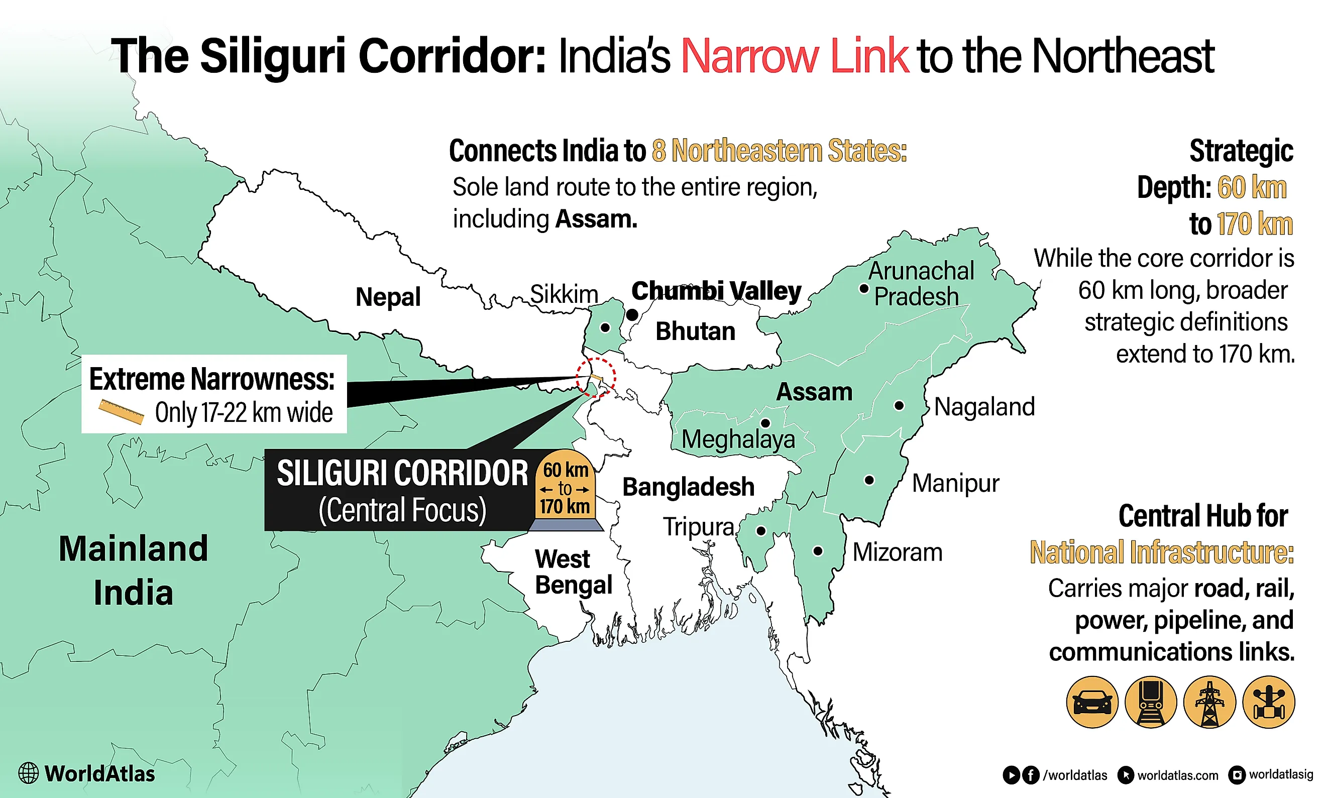
The Siliguri Corridor connects India’s eight northeastern states to the rest of the country through a narrow strip of West Bengal that tightens to 17 to 22 kilometers between Nepal, Bhutan, and Bangladesh. Major roads, rail lines, pipelines, power links, and communication networks serving the region pass through or near this same band of land, making it one of India’s most closely watched geographic chokepoints.
Measurements vary depending on how the corridor is defined. Some summaries describe a roughly 60-kilometer-long core corridor, while broader strategic descriptions place it at around 170 kilometers long and up to 60 kilometers wide.
Location and Surrounding Borders

The corridor is flanked by Nepal to the west and northwest, Bhutan to the north, and Bangladesh to the south. Bhutan’s southern border traces much of the strip’s upper edge before giving way eastward to Assam, while Bangladesh forms the southern constraint created by the 1947 Partition of British India.
The broader strategic context involves the Chumbi Valley, a narrow tongue of Tibetan territory administered by China that projects southward between Bhutan and the Indian state of Sikkim and lies roughly 130 kilometers north of the Siliguri Corridor. While the Chumbi Valley does not directly border the corridor, it places Chinese-administered territory at a relatively short overland distance from the strip, a geographic fact that Indian military planners and strategic analysts have discussed in published assessments.
Why the Corridor Is Called the Chicken’s Neck

The informal name derives from the corridor's shape when viewed on a map. The bulk of India's landmass sits to the west, and the eight northeastern states extend to the east. The narrow strip connecting them, pinched between Nepal, Bhutan, and Bangladesh, resembles the neck of a chicken connecting the body to the head. The name appears in Indian strategic literature, media, and policy commentary and is widely understood as a geographic descriptor rather than a political judgment.
The corridor's narrowness is a product of colonial boundary-drawing. The 1947 Partition of British India divided the Bengal province into West Bengal, which remained part of India, and East Bengal, which became a province of Pakistan. East Bengal was subsequently renamed East Pakistan and became the independent country of Bangladesh following the 1971 Bangladesh Liberation War. The borders established at Partition placed what is now Bangladesh's Rangpur Division directly south of the corridor, producing the geographic constraint that defines the strip today. Before Partition, travel between Bengal and Assam was unrestricted across a contiguous territory.
Road, Rail, and Utility Links

National Highway 27 is the primary road artery running through the corridor, maintained by the Ministry of Road Transport and Highways. NH27 was assigned its current number under the national highway renumbering system introduced between 2010 and 2011, consolidating sections of several older highway designations. The highway passes through Siliguri in West Bengal, continuing through Jalpaiguri, Cooch Behar, and Alipurduar before crossing into Assam. It connects Siliguri to Guwahati and then continues east to Silchar, serving as a major overland supply route for the northeastern states.
The New Jalpaiguri railway junction, located just south of Siliguri, is the main rail gateway to the northeast. Trains passing through New Jalpaiguri connect West Bengal to Assam and the broader northeastern network under the Northeast Frontier Railway zone, headquartered in Maligaon, Guwahati. The junction handles both passenger and freight traffic and is one of the key rail nodes linking North Bengal with the Northeast.
The corridor also accommodates high-voltage power transmission lines, natural gas pipelines, and fiber optic infrastructure serving the northeastern states, much of it concentrated within the same narrow geographic strip.
Strategic Significance

Indian military and strategic analysts have described the Siliguri Corridor as one of the country's most sensitive geographic points, arguing that a disruption of the strip could threaten the land connection between mainland India and the northeastern states. This assessment appears in published documents from the Indian Army and in reports from the Manohar Parrikar Institute for Defence Studies and Analyses (MP-IDSA) in New Delhi.
The corridor gained heightened attention following the 2017 Doklam standoff, a 73-day confrontation between Indian and Chinese forces at a plateau near the Bhutan-China-India tri-junction, approximately 100 kilometers northeast of the corridor. The standoff began in June 2017 when Indian troops blocked a Chinese road construction effort on territory claimed by Bhutan, and it ended in August 2017 following diplomatic negotiations. Analysts noted the standoff's proximity to the corridor in coverage at the time, though Chinese and Indian officials framed the incident primarily as a boundary dispute involving Bhutan.
Infrastructure Upgrades: Status as of Early 2026

The Indian government has undertaken several infrastructure projects intended to increase the corridor's connectivity and reduce dependence on road transport through the strip.
The Bogibeel Bridge, inaugurated in December 2018 by Prime Minister Narendra Modi, spans the Brahmaputra River in Assam and provides both road and rail connectivity, reducing transit time between Assam and Arunachal Pradesh. While the bridge is located east of the corridor proper, it is part of the broader northeastern connectivity push that the corridor anchors.
The Sela Tunnel project in Arunachal Pradesh, inaugurated on March 9, 2024, by Prime Minister Modi, provides all-weather road access across the Sela Pass at an altitude of approximately 13,000 feet. The project, built by the Border Roads Organization at a cost of 825 crore rupees, consists of two tunnels: Tunnel 1 runs 980 meters, and Tunnel 2 runs 1,555 meters, with 8.78 kilometers of approach roads connecting them. The tunnels bypass the weather-affected Sela Pass, reducing the distance between Dirang and Tawang by approximately 10 kilometers and cutting travel time by roughly 90 minutes.
In March 2024, the Indian government inaugurated the four-laning of the Ghoshpukur-Dhupguri section of NH 27 and the four-lane Islampur Bypass, two road projects in northern West Bengal worth more than 3,000 crore rupees.
Rail connectivity from Assam into Meghalaya remains uneven, with different proposed sections at different stages. The Tetelia-Kamalajari section of the Tetelia-Byrnihat line received CRS authorization in October 2018 and was handed over to Open Line in June 2019, while work on the Meghalaya portion toward Byrnihat has remained suspended since May 2017. A separate proposed line, the 135-kilometer Chaparmukh-Jowai broad-gauge route, was included in the 2024 to 2025 railway budget. However, no firm date had been set for the preliminary survey as of early 2026, according to Northeast Frontier Railway sources reported by The Shillong Times in December 2025.