Countries That Border Three Oceans
Three countries clearly border three oceans: Russia, Canada, and the United States, each of which has direct coastlines on the Pacific, the Atlantic, and the Arctic. With the Southern Ocean now formally recognized as the fifth world ocean by the US National Oceanic and Atmospheric Administration (since February 2021) and by the National Geographic Society (since June 2021), three additional candidates enter the conversation under broader interpretations: Australia (Pacific, Indian, Southern), South Africa (Atlantic, Indian, Southern), and Chile (Pacific, Atlantic at Cape Horn, and the Southern Ocean by way of its Antarctic territorial claim). Two further countries (France and the United Kingdom) reach into four of the five oceans through their overseas territories, which puts them in a category of their own. The complete list depends on how strictly the borders of the Southern Ocean are drawn, and on whether overseas territories count as part of the home country.
The Five Oceans Today

For most of the 20th century, mainstream geography taught a four-ocean model: the Pacific, the Atlantic, the Indian, and the Arctic. The Southern Ocean (the waters surrounding Antarctica) had been recognized in the International Hydrographic Organization's 1937 guidelines, but the IHO repealed that designation in 1953 citing controversy, and for decades the waters around Antarctica were absorbed into the southern extensions of the Atlantic, Pacific, and Indian Oceans.
The five-ocean model began returning in the late 1990s. The US Board on Geographic Names recognized the Southern Ocean as a distinct body in 1999. The IHO drafted a new definition in 2000 (placing the Southern Ocean's northern boundary at 60° south latitude), but member states still have not formally adopted it. NOAA officially recognized the Southern Ocean in February 2021, and the National Geographic Society, which had recognized only four oceans on its maps since it began publishing them in 1915, added the Southern Ocean on World Oceans Day, June 8, 2021. Most major US science institutions and education systems now use the five-ocean model.
This article uses the five-ocean model: Pacific, Atlantic, Indian, Arctic, and Southern. By area, the Pacific is the largest (about 63 million square miles), followed by the Atlantic (41 million), the Indian (27 million), the Southern (7.8 million), and the Arctic (5.4 million). Together the five oceans cover roughly 71 percent of Earth's surface and hold about 97 percent of the planet's water.
Three Countries Border Three Oceans Outright
Russia, Canada, and the United States all have continuous mainland coastlines on the Pacific, the Atlantic, and the Arctic. No other country in the world matches all three under any reasonable definition of where those oceans begin and end.
Russia
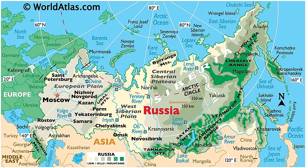
Russia is the world's largest country by area (about 6.6 million square miles, or 17.1 million km²) and stretches across eleven time zones, occupying much of eastern Europe and northern Asia. It shares land borders with 14 countries and maritime borders with Japan and the United States. Its Arctic frontage is the longest of any nation, running across the White, Barents, Kara, Laptev, East Siberian, and Chukchi Seas; its Pacific frontage covers the Bering Sea, the Sea of Okhotsk, and the Sea of Japan. The Atlantic connection is indirect (Russia has no coastline on the open Atlantic) but it borders the Baltic Sea at Saint Petersburg and the Kaliningrad exclave, and the Black Sea at Sochi and Crimea, both of which are marginal seas of the Atlantic system.
The narrowest point between Russia and the United States lies in the Bering Strait, where the Diomede Islands sit only 2.4 miles (3.8 km) apart: Big Diomede (Russian, also called Ratmanov Island) and Little Diomede (American). The strait itself separates the Bering Sea (Pacific) to the south from the Chukchi Sea (Arctic) to the north, making it the only natural sea passage between the Pacific and the Arctic. The International Date Line runs between the two islands.
Canada
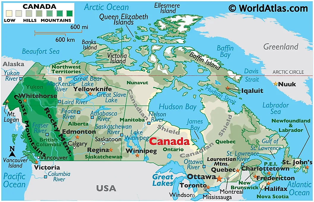
Canada is the second-largest country in the world by area (about 3.85 million square miles or 9.98 million km²) and has the longest coastline of any nation: 151,019 miles (243,042 km) per the CIA World Factbook, more than six times the length of Russia's coastline. Eleven of Canada's thirteen provinces and territories border at least one ocean. The only two landlocked ones are Alberta and Saskatchewan. The Pacific coast lies in British Columbia, the Atlantic coast in Newfoundland and Labrador, Quebec, New Brunswick, Nova Scotia, and Prince Edward Island, and the Arctic coast in Yukon, the Northwest Territories, Nunavut, and the northern reaches of Quebec and Manitoba (whose Hudson Bay shoreline is considered part of the Arctic basin by most definitions).
Three of the world's ten largest islands lie in Canada's Arctic archipelago: Baffin Island (the fifth-largest island in the world at 195,928 square miles), Victoria Island (the ninth-largest at 83,896 square miles), and Ellesmere Island (the tenth-largest at 75,767 square miles). Canadian Forces Station Alert, on the northern tip of Ellesmere Island at latitude 82°30' north, is the northernmost permanently inhabited place on Earth.
United States
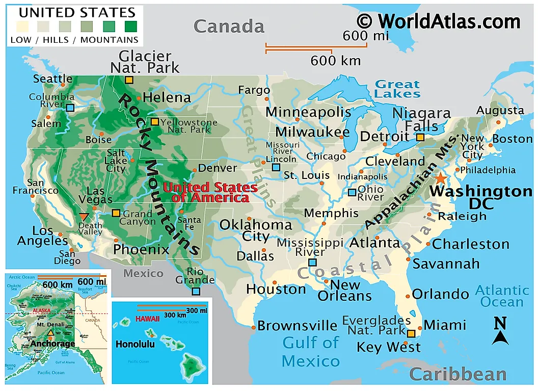
The United States borders three oceans, primarily because of Alaska. The contiguous 48 states give the country its Pacific (California, Oregon, Washington) and Atlantic (the entire Eastern Seaboard between Maine and Florida) coastlines; Alaska adds substantial frontage on the Pacific (Bering Sea, Gulf of Alaska, and Alexander Archipelago) and on the Arctic (the Beaufort Sea and Chukchi Sea along Alaska's North Slope). Alaska's North Slope coastline runs more than 1,000 miles along the Arctic Ocean, reaching its northernmost point at Point Barrow (now officially Utqiaġvik) at latitude 71°23' north.
The United States is often left off lists of three-ocean countries (the source article that preceded this rewrite was one example) because the Arctic frontage is so far from the contiguous 48 and so often forgotten. By the standard NOAA and IHO definitions, however, the Beaufort Sea is unambiguously part of the Arctic Ocean, and Alaska's coastline on it places the US in the same three-ocean category as Russia and Canada. With Hawaii in the central Pacific and various unincorporated territories adding further Atlantic (Puerto Rico, US Virgin Islands) and Pacific (Guam, American Samoa, Northern Mariana Islands) reach, the US has the third-longest coastline in the world.
Three More If You Stretch The Definitions
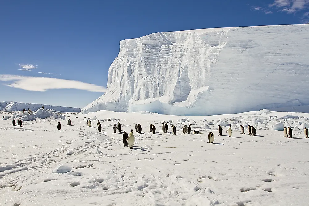
Once the Southern Ocean is treated as separate, a second tier of three-ocean countries emerges, although exactly which countries belong depends on where the Southern Ocean's northern boundary is drawn. The strict modern IHO and NOAA definition places the boundary at 60° south, which means no mainland country reaches it directly (the northern tip of the Antarctic Peninsula sits at about 63° south). Under that strict reading, the only territory in the Southern Ocean belongs to the seven Antarctic claimant nations.
Many older usages, however, and the working definition used by the Australian Government and by South African geography textbooks, treat the Southern Ocean as extending up to the southern coastlines of the major Southern Hemisphere continents. Under those broader definitions, the following three countries enter the three-ocean conversation.
Australia
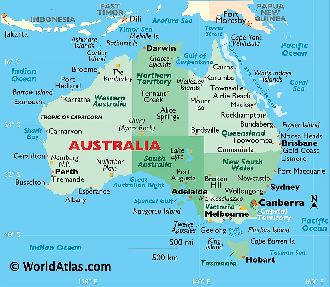
Australia is the only continent that is also a single sovereign country, and it borders three oceans under the Australian Government's own definitions: the Indian Ocean to the west, the Pacific Ocean (specifically the Coral Sea and Tasman Sea) to the east, and the Southern Ocean along its southern coast. Geoscience Australia and the Australian Hydrographic Service designate the waters off Australia's southern coastline (from Cape Leeuwin in Western Australia to South East Cape in Tasmania) as Southern Ocean, even though this places the Southern Ocean's northern limit well above 60° south in Australian practice. Outside Australia, this is contested: the IHO's draft 2000 definition would assign those same waters to the Indian Ocean (west) and Pacific Ocean (east). Under either reading, Australia clearly borders at least the Indian and Pacific.
South Africa
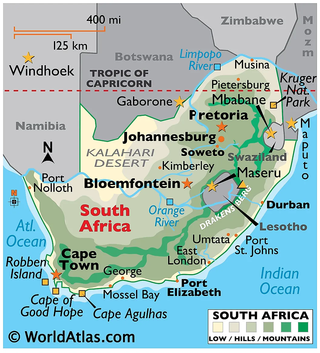
South Africa is unique in the African continent for fronting two oceans: the Atlantic on its western coast (from the Namibian border down to Cape Point near Cape Town) and the Indian Ocean on its eastern coast (from Cape Agulhas to the Mozambique border). Cape Agulhas at 34°50' south is the official meeting point of the two oceans and the southernmost tip of the African mainland. Under the strict 60°S definition, South Africa does not directly border the Southern Ocean, but South African geography sometimes treats the cold Antarctic-derived waters off the south coast as Southern Ocean, and South Africa operates a research and rescue base on Marion Island (in the Prince Edward Islands group) at 46° south, which under any broader Southern Ocean definition is firmly inside it.
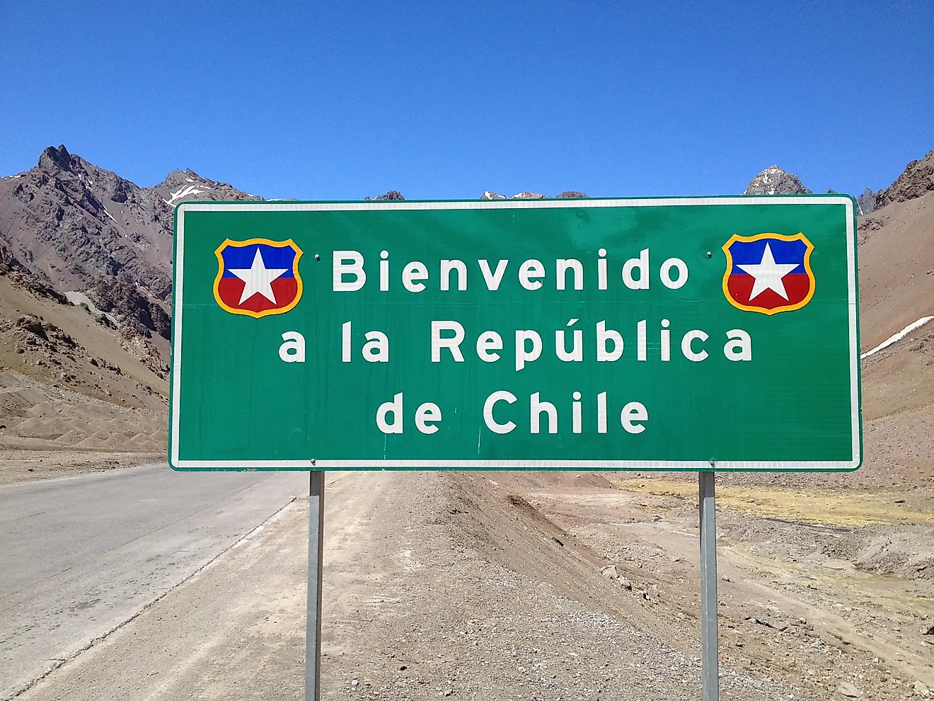
Chile
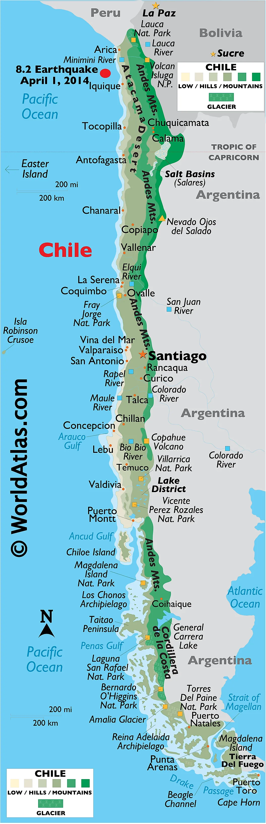
Chile is the most marginal case. Its main coastline runs along the Pacific for more than 4,000 miles from the Peruvian border down to Cape Horn at 55°59' south, the southernmost point of South America. At Cape Horn the Pacific meets the Atlantic, and Chile's southernmost islands (Cape Horn itself, Diego Ramírez Islands) are bathed by the Drake Passage, which carries the Antarctic Circumpolar Current from the Pacific into the Atlantic. Chile also maintains a claim to Antarctic territory (the Chilean Antarctic Territory, 53°W to 90°W), which extends well south of 60° and into the Southern Ocean under any definition. Whether to count Chile as a three-ocean country comes down to whether Cape Horn's waters are "Atlantic" enough and whether Antarctic claims are recognized; the answer is yes under broad interpretations and no under the strictest reading.
Four Oceans Through Overseas Territories: France And The United Kingdom
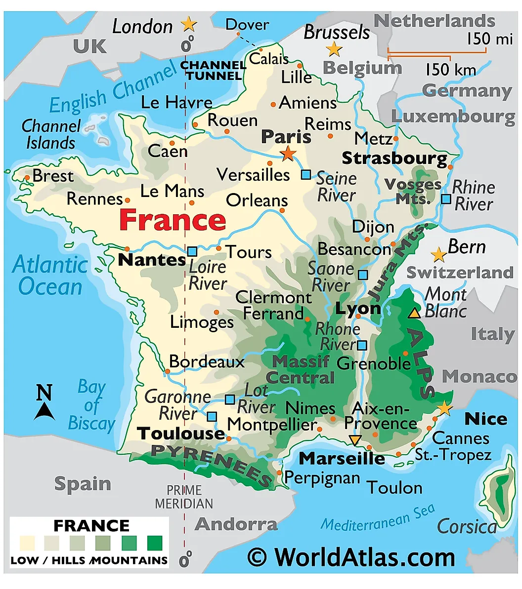
If overseas territories count as the home country, two European powers each border four of the five oceans. France touches the Atlantic through metropolitan France, French Guiana, Saint Pierre and Miquelon, and the French Antilles (Martinique, Guadeloupe); the Pacific through French Polynesia, New Caledonia, and Wallis and Futuna; the Indian through Réunion and Mayotte; and the Southern through Adélie Land (the French Antarctic claim) and the French Southern and Antarctic Lands (TAAF). The United Kingdom does the same: Atlantic via the home islands, the Falkland Islands, Bermuda, and Saint Helena; Pacific via the Pitcairn Islands; Indian via the British Indian Ocean Territory (the Chagos Archipelago); and Southern via the British Antarctic Territory and South Georgia and the South Sandwich Islands. Neither country reaches the Arctic, so neither claims a five-ocean record. Norway has Atlantic and Arctic mainland coasts and an Antarctic claim (Queen Maud Land plus Bouvet Island and Peter I Island in the Southern Ocean), giving it three oceans by the territorial counting.
Continents That Border Three Or More Oceans
Two continents border three oceans under the historical four-ocean model: North America borders the Arctic, Pacific, and Atlantic, and Asia borders the Arctic, Pacific, and Indian. Under the five-ocean model that adds the Southern Ocean, two more continents enter: Australia borders the Pacific, Indian, and Southern, and Africa borders the Atlantic, Indian, and (under broad readings) Southern. South America borders the Pacific, Atlantic, and (under broad readings) Southern. Only Europe and Antarctica fail to reach three. Europe directly borders the Atlantic and Arctic only; Antarctica borders the Southern Ocean alone, by definition.
Why The Number Matters
The countries that border three or more oceans share more than a quirk of geography. Russia, Canada, and the United States have all developed substantial Arctic policy capacity, polar military and research infrastructure, and competing claims to extended continental shelves under the United Nations Convention on the Law of the Sea (UNCLOS), where seabed claims north of 60° will become increasingly consequential as Arctic sea ice retreats. Australia, South Africa, and Chile share a different but equally consequential interest in Antarctic and Southern Ocean governance, particularly through the Antarctic Treaty System (in force since 1961) and the Commission for the Conservation of Antarctic Marine Living Resources (CCAMLR). For maritime trade, fisheries, and climate science, the number of oceans a country touches is rarely an academic question.