The 10 Wettest Countries in the World
Rainfall carves river systems, feeds rainforests, fills reservoirs, and sustains the biodiversity that keeps ecosystems alive. But precipitation is not distributed equally across the globe. Differences in rainfall levels can be attributed to factors like the Intertropical Convergence Zone (ITCZ), where winds from both hemispheres collide and fuel intense storms; orographic lift, in which moisture-laden air rises over mountains and cools, releasing torrential rain; and proximity to warm ocean surfaces, which fuel evaporation and feed the atmosphere with moisture.
Here, we list the 10 wettest countries in the world by average annual precipitation, drawing on 30-year climate averages from the World Bank and national meteorological observations. All figures represent country-wide averages, not records from individual weather stations.
The 10 Wettest Countries in the World
| Rank | Country | Average Annual Rainfall |
|---|---|---|
| 1 | Colombia | 3,240 mm (127.6 inches) |
| 2 | São Tomé & Príncipe | 3,200 mm (126.0 inches) |
| 3 | Papua New Guinea | 3,142 mm (123.7 inches) |
| 4 | Solomon Islands | 3,028 mm (119.2 inches) |
| 5 | Panama | 2,928 mm (115.3 inches) |
| 6 | Costa Rica | 2,926 mm (115.2 inches) |
| 7 | Samoa | 2,880 mm (113.4 inches) |
| 8 | Malaysia | 2,875 mm (113.2 inches) |
| 9 | Brunei | 2,722 mm (107.2 inches) |
| 10 | Indonesia | 2,702 mm (106.4 inches) |
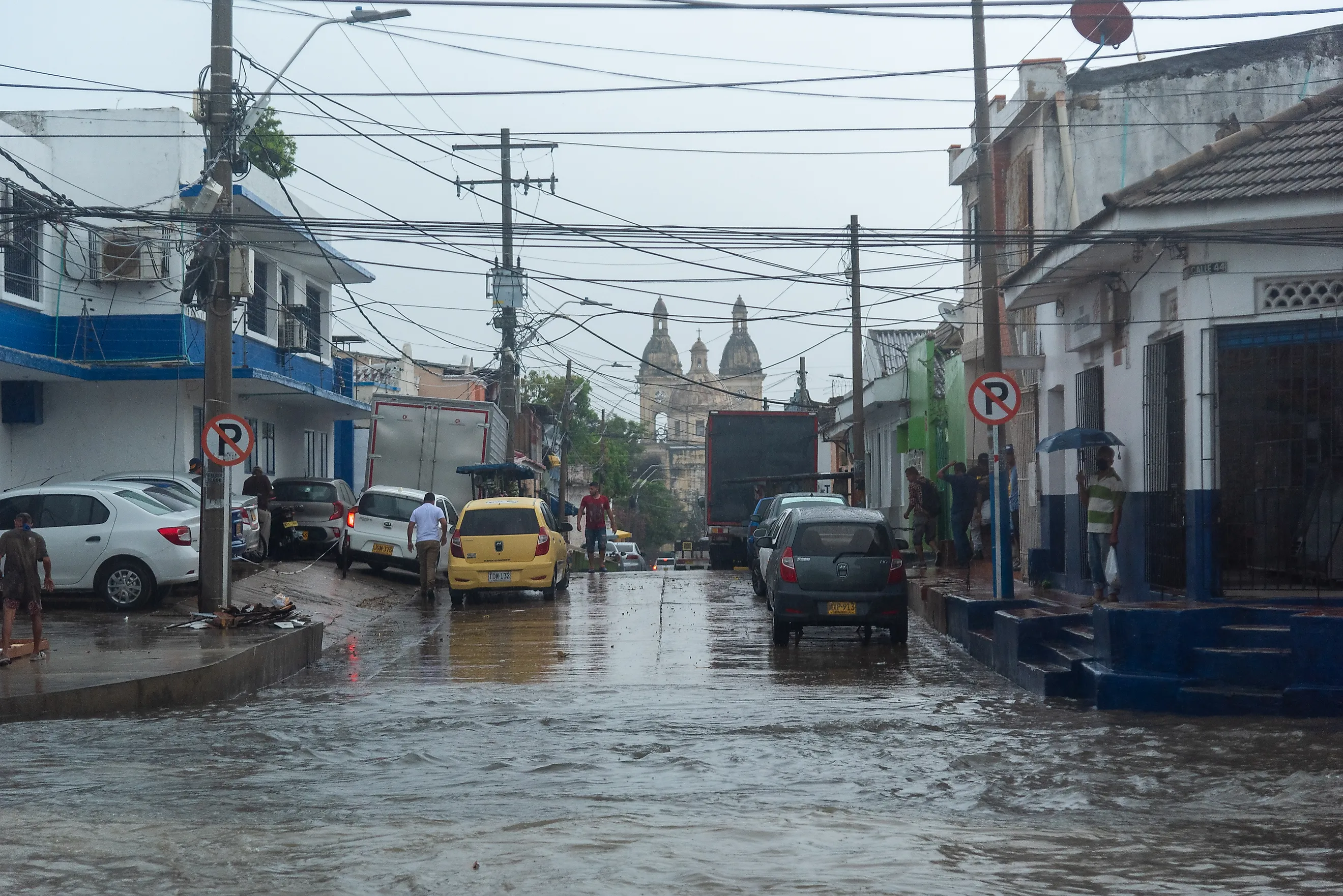
1. Colombia - 3,240 mm (127.6 inches)

Colombia ranks among the top in World Bank/FAO-based rankings of the world's wettest countries. Three separate branches of the Andes straddle the country. Warm moisture carried inland from both the Pacific Ocean and the Caribbean Sea is forced upward by those mountain walls. As the air rises, it cools, and the moisture condenses into rain. This process is called orographic precipitation.
The country's wettest region, around the municipality of Lloró, receives more than 472.4 in. of precipitation per year. This is one of the highest totals ever recorded for any inhabited location on Earth. The average annual precipitation across Colombia is 127.6 inches. Unlike many tropical countries with a distinct dry season, much of Colombia experiences rainfall year-round, driven by the ITCZ migrating twice annually across its latitude. Colombia's heavy rainfall sustains one of the largest Pacific rainforests in the Americas and feeds the rivers that flow into the Amazon.
2. São Tomé & Príncipe - 3,200 mm (126.0 inches)

São Tomé and Príncipe is a small two-island nation sitting almost directly on the equator in the Gulf of Guinea. Its position along the path of the South Atlantic Convergence Zone, combined with the islands' volcanic topography, makes it one of the wettest places on Earth. The larger island, São Tomé, rises to over 6,561 feet with south-westerly winds from the warm Atlantic transporting moisture up its slopes, producing predictable, drenching results. The wet season runs from October through May, and some southern parts of the island can receive well over 275.6 in. annually. The northern coast and the island of Príncipe tend to be somewhat drier. The country's lush, biodiverse forests are a direct product of this extraordinary rainfall, with cocoa cultivation in the archipelago thriving under the near-constant moisture.
3. Papua New Guinea - 3,142 mm (123.7 inches)

Papua New Guinea occupies the eastern half of one of the world's largest and most rugged tropical islands. Its terrain ensures that rainfall is captured and amplified across nearly all elevations. The country's interior highlands rise above 13,123 ft., and the northwest monsoon season from December to March delivers enormous rainfall on windward mountain faces. The Southeast Trade Winds bring additional rainfall from May to October. The net effect is an average annual precipitation of 123.7 inches across the entire country. Coastal lowlands receive a relatively small share, but some highland valleys and south-facing slopes receive totals that rival those of Colombia's wettest regions.
Papua New Guinea is home to an enormous tropical rainforest with thousands of unique plant and animal species. This biodiversity hotspot depends entirely on the country's reliable rainfall. Flash flooding and landslides are significant hazards for communities in steep terrain during peak monsoon months.
4. Solomon Islands - 3,028 mm (119.2 inches)

Spread across a vast archipelago in the southwestern Pacific, the Solomon Islands receive 119.2 inches of rain every year. The South Pacific Convergence Zone brings prolonged and widespread rainfall. The annual northwest monsoon compounds these effects from November to April. The climate across the Solomon Islands is relatively uniform, with few dry areas. Even the drier northern islands typically receive more than 78.7 in. of precipitation per year. Cyclones are an additional precipitation driver in the summer, occasionally delivering months' worth of rain in just a few days. This rainfall is both a blessing and a challenge. It sustains lush forests and freshwater systems, yet flooding remains a concern in low-lying communities.
5. Panama - 2,928 mm (115.3 inches)

Just under 50 miles wide at its narrowest point, Panama acts as a land bridge between two great oceans. Trade winds, funnelled across the Caribbean, carry moisture westward. When they hit the mountainous spine running the length of the country, they are forced upward and unload torrential rains. The Pacific and Caribbean coasts exhibit distinct rainfall patterns, with the country's average annual precipitation being about 115.3 inches. Panama's Caribbean coast is one of the wettest areas in the Western Hemisphere, receiving up to 196.9 in. annually.
The wet season runs from May to December on the Pacific side, while rainfall on the Caribbean side is year-round. The Panama Canal itself is entirely dependent on this rainfall. Gatun Lake, which provides water for the canal's locks, is replenished exclusively by rainfall.
6. Costa Rica - 2,926 mm (115.2 inches)

Costa Rica sits just north of Panama, shares almost identical geography, and records almost identical rainfall. Like its southern neighbour, Costa Rica is a narrow, mountainous country wedged between the Pacific and the Caribbean. The trade winds that carry moisture from the Atlantic are squeezed for their precipitation as they cross the Central American corridor.
What makes Costa Rica particularly interesting from a climate perspective is its astonishing microclimate diversity. Within a country the size of West Virginia, rainfall varies from fewer than 39.4 in. per year in the dry northwest Pacific coast to over 275.6 in. along the Caribbean slope.
Costa Rica's dry season on the Pacific coast runs from December to April, making it a popular tourist destination. The Caribbean side barely experiences a dry season at all, meanwhile. This range of weather conditions underpins the country's world-famous biodiversity, with roughly 5% of the world's biodiversity found within Costa Rica's landscape.
7. Samoa - 2,880 mm (113.4 inches)

The independent nation of Samoa is a chain of volcanic islands in the South Pacific. The South Pacific Convergence Zone, a diagonal band of clouds and rainfall stretching from the warm waters of the western Pacific, reaches across the islands, especially during the summer wet season from November to April.
Rainfall in Samoa is highly variable across the island chain. The southeastern parts of Upolu, the main island, can receive up to 236.2 in. per year, while the western side is in a rain shadow and may receive as little as 78.7 in. Averaged across the country, the figure settles around 113.4 inches. Cyclones are a periodic feature of Samoa's climate, and in severe years, they can deliver catastrophic rainfall totals in a matter of days, reshaping both landscapes and communities.
8. Malaysia - 2,875 mm (113.2 inches)

Malaysia's almost year-round rainfall is divided between the Malay Peninsula and the states of Sabah and Sarawak on Borneo. The country experiences two distinct monsoon seasons: the southwest monsoon from May to September, and the northeast monsoon from November to March. The country's peninsular geography means that ocean moisture is never far away, even for inland areas. Sabah and Sarawak on Borneo tend to receive even more rain than Peninsular Malaysia, with parts of the interior logging over 196.9 in. per year.
Kuala Lumpur, Malaysia's largest city, averages around 102.4 in. annually. Afternoon thunderstorms are so regular that city residents plan their days around them. Malaysia's palm oil and rubber plantations, as well as its biodiverse rainforests, are the result of this consistent precipitation.
9. Brunei - 2,722 mm (107.2 inches)

Brunei is a tiny nation occupying two strips of land on the northern coast of Borneo. Its seaside location puts it squarely in the path of both the northeast and southwest monsoon seasons, leaving almost no prolonged dry period in the calendar. This distinguishes Brunei from its larger neighbor, Indonesia, which has more pronounced dry seasons in its eastern regions. Unlike Indonesia, Brunei's rainfall patterns across its small and largely forested territory mean precipitation totals are relatively consistent across the country. Inland areas, particularly in Temburong, receive notably higher rainfall than coastal regions. Brunei's vast forests also contribute somewhat to rainfall through transpiration, a process where trees release moisture back into the atmosphere, creating a circular rainfall cycle.
10. Indonesia - 2,702 mm (106.4 inches)

Completing the top ten is Indonesia, perhaps the most geographically remarkable country on this list. The world's 14th-largest country by land area, it has an annual average rainfall of over 106.4 in. While most large countries are pulled toward drier averages by inland continental zones, Indonesia avoids this because its entire territory consists of over 17,000 islands near the equator, ensuring every part of the country is never far from the warm tropical ocean.
The northwest monsoon season brings heavy rain from October to April, drenching the western islands of Sumatra, Kalimantan, and Java. Some parts of western Sumatra receive over 157.5 in. per year. Even in the drier eastern islands, such as Nusa Tenggara, annual totals rarely fall below 39.4 in. Indonesia is one of the world's most biodiverse countries in part because of this reliable rainfall. Its tropical rainforests support more plant and animal species than almost any other nation.
What They Have In Common

Every country on this list lies in the tropics or close to the equator, where large-scale atmospheric circulation helps deliver abundant rainfall. All of them are either island nations or countries with significant coastlines, exposing them to warm ocean evaporation. And finally, most feature significant topographic features, ensuring that moisture-filled air is lifted and forced to release its rain before it can pass inland and dry out.
Understanding where the world's rain falls and why is not merely a curiosity. It's foundational to understanding agriculture, freshwater availability, biodiversity, and human migration in the decades ahead. The 10 countries on this list host some of the planet's most significant wild species, sustained by rainfall patterns shaped by atmospheric interactions with topography. As the climate changes, we will discover whether these countries retain their place as the most rain-drenched on Earth.