San Joaquin Valley
Four million Californians live in the San Joaquin Valley, one of the most prolific agricultural areas in the world. It comprises the southern portion of California's Central Valley. Because it grows various crops, it has been dubbed "the food basket of the world." It is also the most extensive wine region in the state, with 151,000 acres of vineyards.
Geography Of San Joaquin Valley

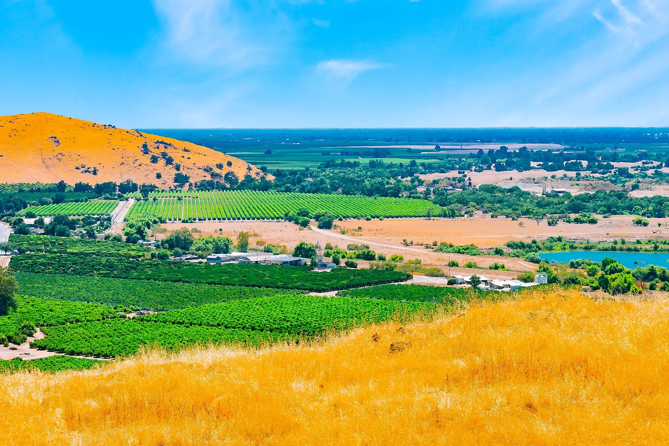
The southern portion of California's enormous Central Valley is known as the San Joaquin Valley, located in the state's central region. It is mostly drained by the San Joaquin River and is located between the Sierra Nevada in the east and the Coast Ranges in the west. This valley is located south of Sacramento Valley, which constitutes the northern portion of Central Valley. The San Joaquin and Sacramento Valleys converge at the Delta region, where the Sacramento and San Joaquin Rivers' combined discharge travels via the Carquinez Strait, the Central Valley's sole natural exit, on its way to San Francisco Bay and the Pacific Ocean. San Joaquin, Stanislaus, Merced, Madera, Fresno, Kings, Tulare, and Kare are among the eight counties that make up the San Joaquin Valley region. Large cities like Fresno and Bakersfield, national parks like Yosemite and Kings, millions of people, and productive farmland are all present in the region. The San Joaquin Valley is one of the most fertile agricultural areas in the country that depends on water for its multi-billion-dollar agricultural industry.
Climate Of San Joaquin Valley
The valley is long and flat, with hot, dry summers and mild, foggy winters that make it one of the world's most productive agricultural regions. The average yearly temperature is 16°C, with August and December recording the highest (23°C) and lowest (9°C) average temperatures, respectively. On average, San Joaquin Valley gets 146.2mm of precipitation each year, with February being the wettest month with an average precipitation of 40.1mm. The average annual relative humidity is around 61%, with a wind speed of 11km/h.
Geology Of San Joaquin Valley

A forearc basin is what the San Joaquin Valley is, which essentially implies that it is a basin that formed in front of a mountain range. The Valley was created during the Mesozoic, more than 65 million years ago, when subduction occurred off the coast of the Pacific Ocean in California. The San Joaquin Valley is sometimes referred to as a remnant arc-trench gap because it is bounded to the west by the California Coast Ranges, which represent a zone of folding and thrusting associated with the ancient subduction zone, and to the east by the Sierra Nevadas, which represent the eroded roots of an ancient volcanic arc that was also associated with the subduction zone. The San Joaquin Valley was an inland sea between two mountain ranges when it originally developed. Even after the San Andreas Fault formed, this arrangement persisted. But as the Sierras' volcanic covering eroded away, the resulting debris was thrown into the Valley below. The Coast Ranges were also being eroded and thrown into the Valley at the same time. As a result, the inland sea was drained to form the present-day continental basin.
History Of San Joaquin Valley
Lt. Gabriel Moraga of the Spanish Army was the first to visit San Joaquin Valley, which was formerly known as the Valle de Los Tulares (Valley of the Tule Grass). He left the San Jose Mission (Saint Joseph) in 1808 to look for prospective locations for future Christian missions from which to evangelize native Californians. In honor of the grandfather of Jesus and Mary, he gave the name San Joaquin (Saint Joachim) to a little creek during his exploration. Later, when it was discovered that the creek entered a bigger river, it was given the same name as well. The name subsequently spread to the valley since the river was the main ocean-going watercourse in the region. Over time, the Spanish presence developed into dominion, which was not peacefully transferred from Spain to Mexico and later the United States. The valley would become "the food basket of the world" and the source of the majority of California's agricultural exports after the arrival of the Spanish, Portuguese, Italians, and other immigrants. During its perpetual growing season, a wide range of conventionally Mediterranean and Middle Eastern crops can be produced, while ranching and dairying are also significant industries. However, the historic lakes have vanished, and in the 19th and 20th centuries, irrigation for agriculture resulted in the extinction of 95% of the valley's wetlands. The valley has become a semi-arid desert in numerous parts.
Wildlife In San Joaquin Valley

The San Joaquin Valley in California is home to a wide variety of fish, insects, birds, and other species. Numerous waterfowl, turtles, deer, and many other species that call the San Joaquin Valley home are housed in its rivers, streams, and wildlife sanctuaries. The Valley is situated in the middle of the Pacific Flyway, a significant migration path for birds and waterfowl. Additionally, this region contains the biggest continuous patch of riparian forest in the San Joaquin Valley. Within the region's 2,200 acres of river floodplain, more than 500,000 willow, oak, and cottonwood trees are found, along with blackberry and rose bushes. Several faunal species, including the San Joaquin kit fox, minks, garter snakes, and endangered brush bunnies, find sanctuary in these riparian corridors. Farmers' attempts to capture water that would otherwise evaporate from Los Banos Creek Reservoir have helped this environment, which was previously in need of water.
Agriculture In San Joaquin Valley

Some of the country's excellent agricultural land is found in the San Joaquin Valley. A vast range of agricultural products is produced in the area and exported worldwide. The San Joaquin Valley's economy heavily depends on the agricultural sector. The entire value of agricultural products in the eight counties in the region in 2015 was $34,706,819,390, according to crop reports. The top ten crops grown in the area are, in descending order: almonds, grapes, alfalfa, wheat, pistachios, tomatoes, oranges, walnuts, cotton, and corn. These ten goods account for $16,575,261,000, or 48%, of the value of all agricultural goods. The San Joaquin Valley spans an area of around 27,478 square miles. 7,948 square miles of this region are classified as Prime Farmland. These classifications are based on the quality of the soil, climate, and terrain in relation to agricultural production. 5,087,200 acres are used for farming, of which 3,752,302 or 74% are used for one of the top 10 crops. This classification study was carried out by the California Department of Conservation: Farmland Mapping and Monitoring Program.
Attractions In San Joaquin Valley
Forestiere Underground Gardens

This is a fascinating historical site in Fresno. Baldassare Forestiere, a Sicilian immigrant, started work on the gardens in 1906 by excavating 70 acres beneath the hardpan soil and planting citrus trees there. It took 40 years to accomplish this absolutely unbelievable masterpiece. Forestiere designed a stunning underground area for his private living quarters and commercial crops using a special skylight system. Bedrooms, a library, patios, grottos, and a fishpond are all part of the tunnel system.
Kern County Museum

With a pioneer hamlet of more than 50 reproduced and restored structures, including Merle Haggard's childhood home and a courtyard with exquisitely restored antique neon signs, this museum brings local history to life. Both beautiful artifacts from Bakersfield's musical golden age and a sizable (and somewhat unsettling) display of taxidermy fauna may be found in the main building.
Cedar View Winery
The Cedar View Winery is a cozy place to enjoy a glass of wine and magnificent views of the Sierra Nevada mountains. It is located on the Blossom Trail's easternmost reaches.
Woodward Park
The largest park in Fresno contains a 300-acre BBQ area, lakes and ponds, a Japanese garden, and a sizable amphitheater for Shakespearean and other shows.
This Valley, which is the largest agricultural region in California and a significant contributor to the nation's food supply, plays an essential economic role for the entire country. Many of California's most challenging water management issues, such as groundwater overdraft, drinking water contamination, and losses in native species and habitat, originate in the Valley. Water for irrigation is so essential to sustain the area. Therefore, the San Joaquin Valley's management efforts (such as raising awareness, implementing water conservation policies, etc.) must be of primary concern.


