The Most Isolated Lakes On Earth
Across the Canadian Arctic, hundreds of thousands of lakes have never been touched by a human being. They have no names, no visitors, and no record beyond satellite imagery. They are the extreme end of a spectrum that has no agreed measure: there is no official ranking of the world's most isolated lakes, and no accepted definition of what makes one remote. Distance is part of it, but so is terrain, and so is climate. A lake ringed by mountains and glaciers or sealed under Antarctic ice can sit far beyond reach even when its coordinates are well known. And a lake can be cut off in another way entirely, walled off from the ocean or the water around it for so long that whatever lives inside evolves on its own. It helps to separate remote from inaccessible. Lake Baikal in Russia is about as geographically remote as a lake gets, yet roads, railways, and lakeside towns make it easy to visit. The five lakes below are cut off in one sense or another: some almost impossible to stand beside, some sealed away long enough to grow life found nowhere else.
Lake Vostok, Antarctica

Lake Vostok is a subglacial lake located under 13,100 ft (4,000 m) of ice. The lake has been cut off from the atmosphere and sunlight for millions of years. The lake's depths are over 2,700 ft (800 m), with a surface area around 4,826 mi² (12,500 km²). The largest known subglacial lake in Antarctica, Lake Vostok, is located under the Russian Vostok Station, a research facility on the East Antarctic Ice Sheet. The station itself is known for its isolation, experiencing extremely cold temperatures year-round; the coldest temperature ever recorded on Earth, -128.6 °F (-89.2 °C), was at Vostok Station on July 21, 1983. The lake is crucial for scientific research into extreme sub-ice biology. Sealed from the outside atmosphere under an ice cap for as much as 25 million years, the water in the lake is liquid, kept warm by geothermal heat from Earth's core, and is retained by the high pressure of the ice sheet covering the lake.

In 2012, Russian scientists drilled through the ice sheet, reaching the lake's water. The Russian Arctic and Antarctic Research Institute (AARI) began the drilling project, which took 20 years to complete, breaching the ice shield at a depth of around 12,300 ft (3,760 m). The endeavor was criticized by the international scientific community because of the use of kerosene and antifreeze. They had been used to keep the borehole open but threatened the delicate and ancient ecosystem of the lake. Thousands of unique DNA sequences from bacteria, fungi, and multicellular organisms were discovered, having survived hyper-extreme environmental conditions for millions of years.
Pingualuk Lake, Nunavik, Canada

Pingualuk Lake, also known as Pingualuit Crater Lake, is a clear lake located within a 1.4-million-year-old meteorite impact crater. The lake is found on the Ungava Peninsula in Nunavik, a subarctic territory making up the northernmost third of the province of Quebec. The name means "great land" in the local Inuktitut dialect, and Nunavik is a culturally distinct region that is part of Inuit Nunangat, the traditional Inuit homeland in Canada. Almost a complete circle, Pingualuk Lake's water is exceptionally pure and clear. With its blue water reflecting the Arctic sky, local Inuit call it The Crystal Eye of Nunavik. The lake sits 200 km from Hudson Bay and has no surface inlets or outlets; the water is replenished by rain and melted snow, losing water only to evaporation.

The crater spans over 2 miles (3.4 km), and with a depth of about 876 ft (267 m), it is one of the deepest lakes in North America. Residing inside Parc national des Pingualuit, Pingualuk Lake is frozen almost year-round, with surface melting taking place for around six to eight weeks a year. Under this harsh and nutrient-poor water, the only fish species capable of survival is the Arctic char. The fish entered the lake through ancient glacial meltwater channels and have been trapped and isolated for 6,500 years, surviving on insect larvae, bottom-dwelling organisms, and other Arctic char. With no roads, the park is accessible by bush plane, and the lake itself by hiking. The logistics require months of planning, and most travellers opt for tour packages, at a cost of between $3,800 CAD and $6,800 CAD per person.
Jellyfish Lake, Palau

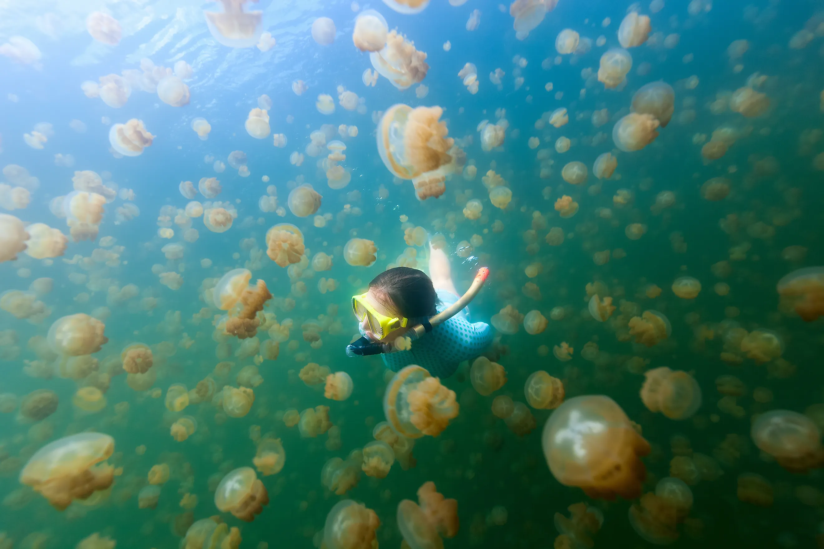
Known locally as Ongeim'l Tketau, Jellyfish Lake is located on Eil Malk island in Palau. The lake was cut off from the ocean thousands of years ago, keeping it isolated on this secluded rock island. The lake's name comes from its unusual lake fauna: millions of golden jellyfish that migrate across the water daily. There are two species of jellyfish: golden jellyfish and moon jellyfish, and both are harmless to humans. Tourism is highly regulated, but it is possible to swim among the jellyfish. Around 12,000 years ago, rising sea levels trapped the jellyfish inside a basin made of porous limestone rock. Sealed off from natural predators, the jellyfish evolved to lose much of their stinging capabilities. Although they still possess nematocysts, the stinging cells, the sting is so mild that it can be barely felt by humans.

The jellyfish follow a peculiar daily routine, tied to the sun's movement across the sky. In the morning, millions of jellyfish gather on the western shore, and as the sun moves, the jellyfish swim horizontally eastward to follow the sunlight. They stop just before a shadow line where trees block the sun. This is to avoid predators such as sea anemones that live in the darker waters. At nightfall, the jellyfish sink to the middle of the lake to feed on nutrient-rich ammonium in the water and then repeat the cycle the next morning. As Jellyfish Lake is located within Palau's UNESCO World Heritage-listed Rock Islands Southern Lagoon, tourism is strictly regulated to protect this rare and fragile isolated ecosystem. Visitors are only permitted to swim on the surface, with no diving at all, especially scuba diving. This is to protect the jellyfish from rising air bubbles, which can tear them apart. There is also a toxic layer of hydrogen sulphide gas sitting at the bottom of the lake below 49 ft (15 m) that is highly dangerous to humans.
Sarez Lake, Tajikistan

Lake Sarez is a large and deep alpine body of water. It is in the isolated high-altitude Pamir Mountains of southeastern Tajikistan. Locally, it is known as the Sleeping Dragon, and it is a relatively new lake, formed in 1911. A massive earthquake triggered a landslide, collapsing an entire mountain and burying the village of Usoi and killing all its inhabitants. The fallen rock created a natural dam across the Murghab (Bartang) River valley. Now known as the Usoi Dam, at 1,860 ft (567 m) in height, it is the tallest dam in the world, natural or human-made. Trapped by this natural dam, the water backed up and submerged the village of Sarez, forming the lake. The lake is about 35 miles (56 km) long, and it holds over 3.8 cubic miles (about 16 cubic km) of water, and sits at an elevation of 10,705 ft (3,263 m) above sea level.
The name Sleeping Dragon is not merely poetic: Lake Sarez sits on an unstable and seismically active zone. Scientists have determined that a future large earthquake could trigger a collapse of the lake's "right bank", which is an unstable mountain face right over the water. If that mountainside falls into the lake all at once, it could trigger a megatsunami, a wave that could easily breach the natural Usoi Dam. A failure of the dam would release water, mud, and rock down into the Bartang, Panj, and Amu Darya river basins, potentially affecting 5 million people in five countries: Tajikistan, Afghanistan, Uzbekistan, Turkmenistan, and Kazakhstan. Advanced early-warning monitoring systems are installed to alert downstream villages. Lake Sarez remains one of the least accessible lakes in the world, as it sits in a highly restricted and dangerous hazard zone, deep in the remote Pamir Mountains. In the unlikely event of receiving the necessary government clearance, in what is essentially an authoritarian dictatorship state, actually trekking to the lake would require physical endurance and a multi-day backcountry journey.
Lake Untersee, Antarctica

Lake Untersee, which means "Lower Lake" in German, is a large and deep freshwater lake in East Antarctica. Like several other Antarctic lakes, Untersee is trapped under a permanent layer of ice 7 to 13 ft (2 to 4 m) thick year-round. Located in the interior of the Gruber Mountains, it is part of Norway's Antarctic territorial claim, Queen Maud Land. Like all other such territorial claims, Norway's sovereignty is frozen under the Antarctic Treaty System. The region is preserved strictly for peaceful scientific cooperation. The lake is around 4 miles (6.5 km) long, 1.6 miles (2.5 km) wide, and has a maximum depth of 554 ft (169 m). There are no outlets, and the lake is fed by seasonal meltwater from the face of the Anuchin Glacier. With no drainage rivers, the lake loses water through ice sublimation and evaporation caused by heavy Antarctic winds.
The chemistry of the lake is unusual. The water column, the stretch of water from the surface to the lakebed, is heavily alkaline. It reaches a highly basic pH of up to 10.4 and has been described as comparable in pH to extra-strength laundry detergent. It is also oversaturated with dissolved oxygen (up to 150%). Its long isolation has left it a living time capsule. In 2008, researchers found that the lake floor is covered by large, conical microbial mats. These are living examples of stromatolites, the oldest fossilized evidence of life on Earth that date back to over 3 billion years. With its pure ecosystem, Lake Untersee's microscopic life exists completely undisturbed. The inhabitants of the lake are resilient microorganisms such as tardigrades, rotifers, and nematodes.
Exploring The Most Isolated Lakes
Isolation takes more than one form. Some of these lakes are physically out of reach: those buried under miles of ice in Antarctica will likely never be seen up close by anyone but a handful of scientists with the funding and equipment to drill down to them, and Sarez sits behind a wall of terrain and government permits. Others can be reached, even swum in, yet stay isolated in a deeper sense, sealed off long enough that the life inside them followed its own path. What the five share is separation, whether from roads and people or from the water and the world they were once part of. That separation is also their protection. With little or no human interference, these remain some of the least disturbed bodies of water on Earth.